
Qld weather in 2022: Biggest storms, floods and cyclones
These are the terrifying, heartbreaking and inspiring tales of Queensland’s wild weather of 2022. SPECIAL REPORT
QLD weather news
Don't miss out on the headlines from QLD weather news. Followed categories will be added to My News.
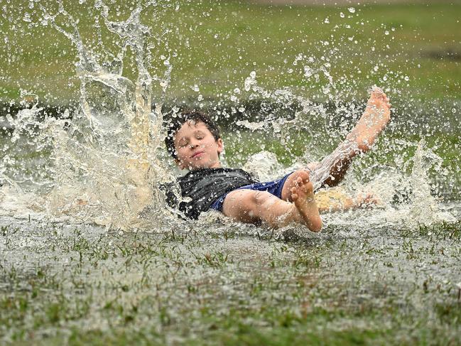
Rain, hail and shine – Queensland has had it all in 2022.
We started the year being hit by cyclones and floods.
We felt the bite of cold snaps in winter, and then endured a 2023 summer of contrasts.
These are the terrifying, heartbreaking and inspiring tales of Queensland’s wild weather of 2022.
JANUARY
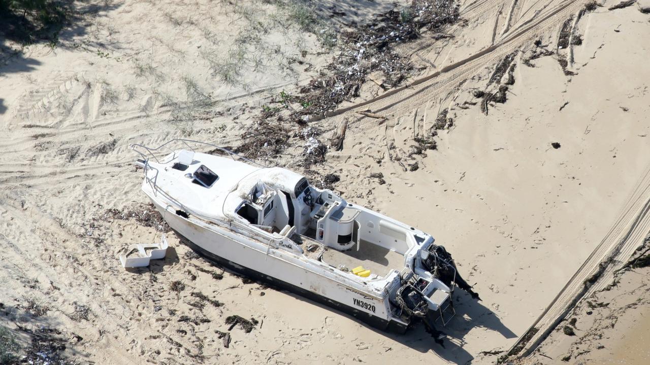
In a horror start to 2022, all Gold Coast beaches from Burleigh to Southport and 14 Sunshine Coast beaches were closed as big swells from Tropical Cyclone Seth pounded the coast.
Ten southeast Queensland dams were spilling over as a week of rain and showers continued.
Gold Coast City Council opened sandbagging stations in anticipation of flash flooding as
Mayor Tom Tate was left preparing to activate the city’s Disaster Management Centre.
“Mother Nature being unpredictable, Seth could turn and say hello to the Gold Coast and if that happens, we’ve got to brace ourselves for a cyclone,” he said.
Meanwhile in the Wide Bay region, Cyclone Yasi had nothing on this.
Highways were washed away and towns cut following an “incredibly rare” weather event that dropped 673mm of rain on January 7.
The weather events far surpassed those from the first 24 hours of Yasi – which in 2011 saw 200-300mm of rain slam north Queensland in a 24-hour time period.
The Bureau of Meteorology called it “incredibly rare”.
“It’s produced thunderstorms that have sat stationary … but overnight … it’s produced a lot of rainfall in a very small area,” a BOM meteorologist said the following day.
“The magnitude of what we saw really escalated during the night.”
By January 16, there were fears a tsunami could impact Queensland following a volcanic eruption near the Tonga Islands.
While it didn’t eventuate, some beaches were closed over the period as a cautious approach was taken.
FEBRUARY
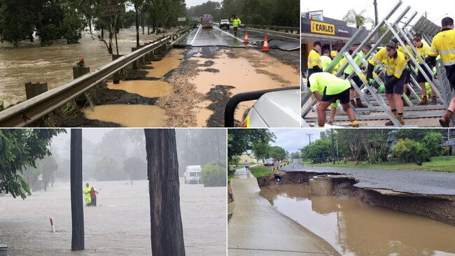
A massive rain event hammered the Gympie and Sunshine Coast regions on February 23.
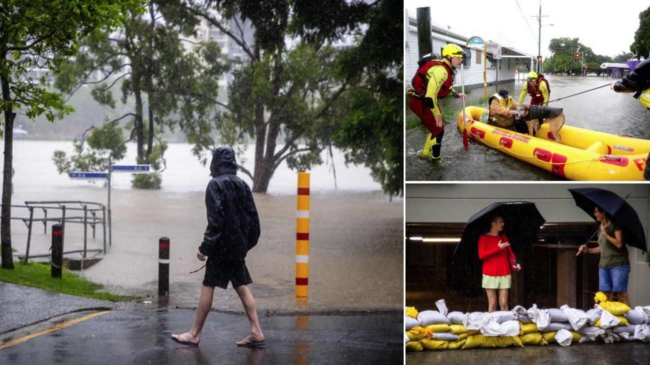
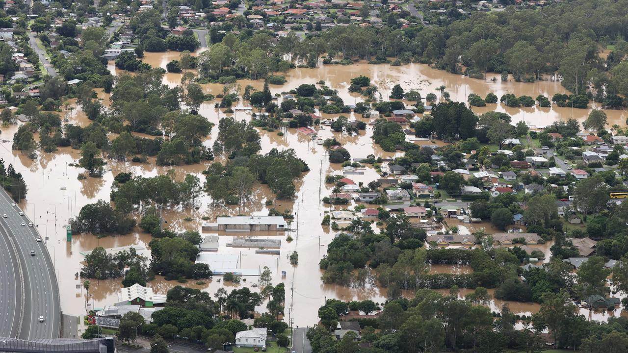
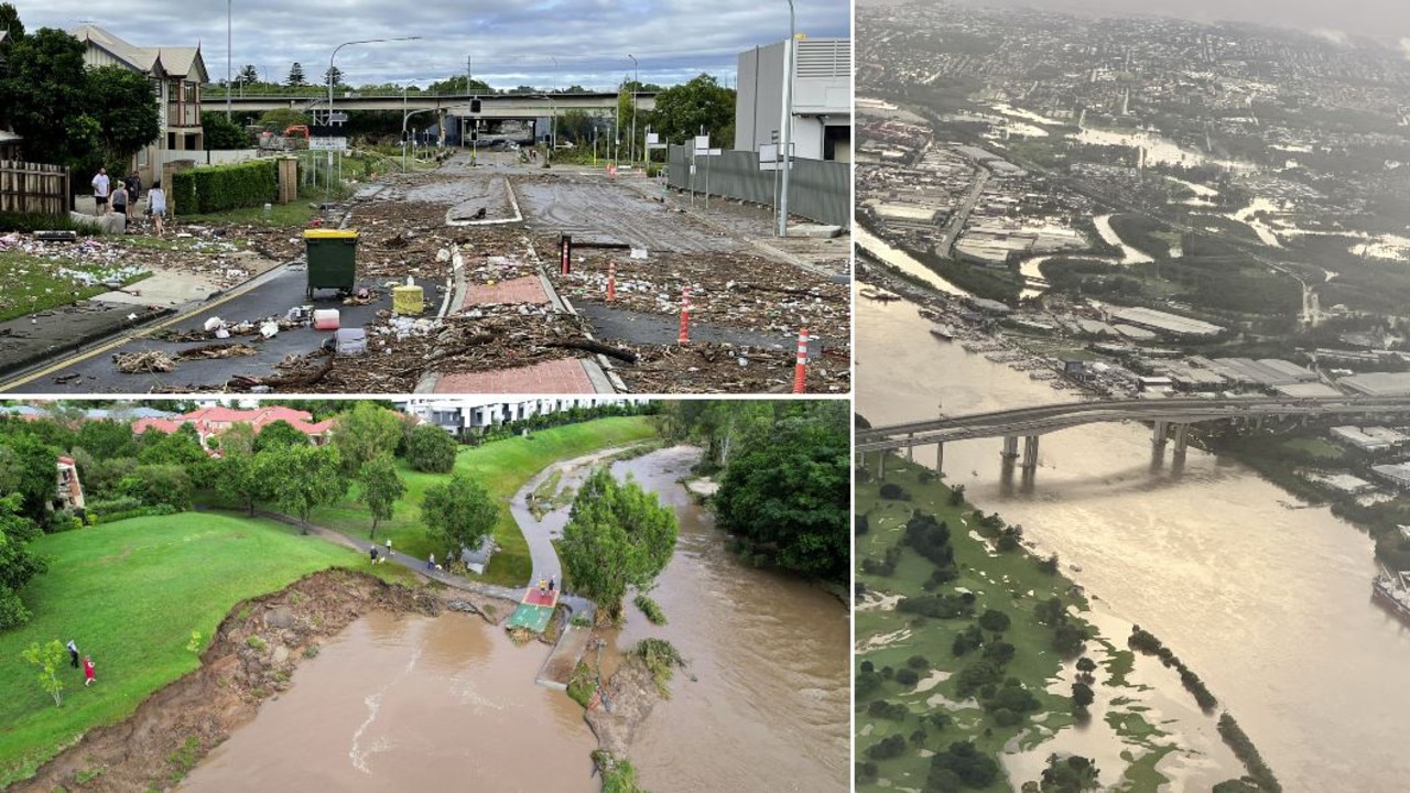
Within days Brisbane and Gold Coast were in the firing line.
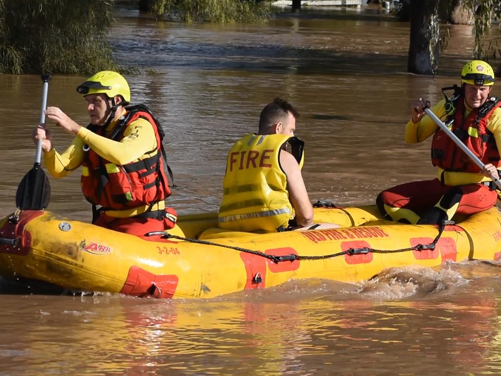
A freight train derailment at Traveston south of Gympie, and more than 100 flood rescues across the Sunshine Coast and Gympie areas alluded to the pain to come further south.
By February 28 schools across South East Queensland were closed as flood water subsided.
Education Minister Grace Grace took a slow and steady approach.
“Our absolute highest priority is the safety of our students, staff, and families,” Minister Grace said.
“As floodwaters recede and we can conduct damage assessments and ensure safe transport, more schools will be able to open.
“Across the 10 LGAs where all schools will remain closed, there will be very limited public transport and travelling by road may be dangerous.
“This means while the school site itself may be safe to open, we do not want people out on the streets trying to get to schools when that could be dangerous.”
MARCH
It was the non-event of 2022.
Premier Annastacia Palaszczuk was left to say sorry for inconveniencing parents by ordering schools across the southeast to close after severe storms failed to eventuate.
“I apologise for the inconvenience,” she said, following major backlash to the closures as southeast Queenslanders woke to calm skies on March 3.
“I do acknowledge there has been some inconvenience today for parents but safety has to come first.
“And at the end of the day, you can only act on the advice that you’re given and that advice given to me and to the senior management staff was that there was going to be very, very severe thunderstorms and hail yesterday.
She said the weather had been “unprecedented”.
“Let’s face it, it’s climate change,” she said.
However there was no false alarm later in the month.
A man and a number of dogs died on March 27, as the Darling Downs town of Dalby was left on emergency flood alert.
Amazing during-and-after pictures show how Brisbane’s flood clean up is going after a week
APRIL
Darling Downs’ pain continued into April as more flash flooding hit the region.
A major flood warning was also issued for Boonah, 100km inland of the Gold Coast.
Meanwhile fears Tropical Cyclone Fili could smash Queensland failed to truly eventuate, though the state copped big swells.
MAY
Some suburbs copped the heaviest downpours in the state on May 20 as a week of wild weather lay ahead.
Firstly a trough working its way down the coast from northern Queensland dumped more than 60mm of rain on Maroochydore within five hours.
By May 25 parts of South East Queensland copped a drenching before a brutal cold snap completed a one-two punch.
Ipswich fell to 5C while it hovered between 8-6C in Toowoomba for most of the week.
Brisbane fell to 9C while Roma hit 7C.
JUNE
Brisbane shivered through its coldest morning in two years and coldest June morning in seven years on June 12 as the mercury dropped to just 6.5C.
The chilly weather came as the cold front that gripped Australia’s east coast the week prior left dry cool air in its wake.
Bureau Meteorologist Pieter Claasson said the southeast in general was four to eight degrees below average.
Ipswich and Beaudesert dropped to near freezing, falling to 1.2C and 1.1C for their coldest morning of the year.
Surfers on the Sunshine Coast would’ve had their wetsuits zipped up with a chilly 5.5C.
Canungra was the coldest spot in the southeast recording 0.5C at 7am.
The cold spread through the Darling Downs region with Warwick recording -0.7C and Oakey at -0.5C.

JULY
Queenslanders were left looking out for their safety as gale-force winds lashed parts of the state on July 21.
Winds reached up to 120km/h across the Capricornia, Fraser Island and Sunshine Coast areas with up to 80km/h winds affecting Townsville, Mackay, Hervey Bay, Moreton Bay and the Gold Coast.
Severe weather warnings were issued for Wide Bay and Burnett and all South East Coast areas.
Boaters and beach goers were told to stay away from all Fraser Island, Sunshine and Gold Coast waters due to dangerous surf conditions, with the system creating 4m swells and risk of erosion.
AUGUST
Cool, cold or plain freezing.
Call it what you like but Queensland’s weather hit chilly lows in a month that also warned of what could lie ahead.
A 1800km blanket of frost stretched from Stanthorpe to the Far North early in the month, bringing subzero temperatures to many parts.
Meanwhile, talk of La Nina returned to our lives.
Flood maps across South East Queensland on August 19 first warned us of the suburbs which could be at risk of further flooding, just months after February’s devastating deluge.
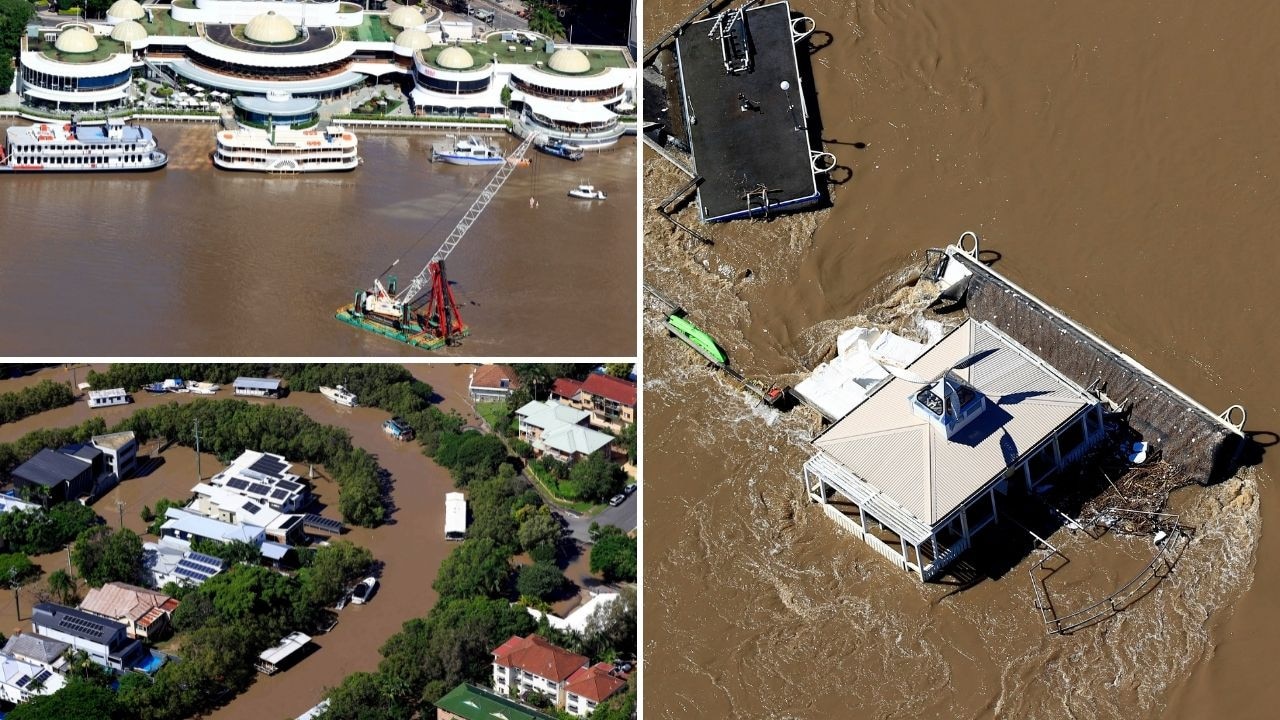
Local councils and state government recovery authorities were left working to avoid a repeat of the widespread floods that hit the state from February to April impacting 23 local government areas and affecting more than 500,000 people and around 18,000 homes or businesses, according to a Deloitte report.
BOM revealed there was a 70 per cent chance of La Nina forming again, which would increase the chances of above-average rainfall during spring and into summer.
In response to the previous floods, the Queensland Government put $224m into disaster recovery and resilience grants for councils, state agencies, and organisations.
As a part of the funding, property valuations for the Resilient Homes Fund voluntary buy back program started in Goodna and Ipswich.
SEPTEMBER
On September 23 monster supercell storms slammed into South East Queensland, dumping an extraordinary 250mm in three hours, causing creeks to rise rapidly, landslides and a flurry of flood warnings.
At 10.42pm the day prior, BOM released a severe thunderstorm weather warning for the southern Gold Coast Hinterland areas warning of heavy rainfall and flash flooding.
By 6am the next day, 312mm had fallen at Upper Springbrook in the Gold Coast Hinterland, 214mm at Mt Nimmel, 207mm at Mt Tamborine, 195mm at Clagiraba Rd, and 174mm in the Numinbah Valley.
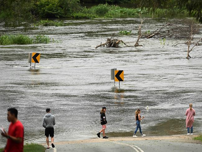
In just one hour overnight, 92mm fell at Springbrook and 104mm fell at Clagiraba Rd.
Meanwhile on September 13 the Bureau of Meteorology officially declared a rare triple La Nina returned to Australia, lasting from spring until the beginning of next year.
However Queenslanders were told to forget the hype and focus on the inevitable wet summer ahead which will likely involve severe floods and cyclones.
“La Nina wont change our outlooks, those things are factored in already and all of our outlooks are showing wetter than average conditions,” BOM’s Dr Andrew Watkins said
“The way the (weather) systems interact, that’s important, not the name La Nina itself because no two summers are going to be the same, this year could be better or worse but there is an elevated risk of flooding due to the wet landscape.”
OCTOBER
Falls of 88mm were recorded in parts of the state on October 5.
The heaviest falls were at Adavale Rd, northwest of Charleville, where 88mm fell in 24 hours, while around 80mm was recorded at two other stations at Upper Quilberry and Loddon.
By October 20 the state battened down for more wild conditions after storms hit the Northern Goldfields and Upper Flinders, Herbert and Lower Burdekin, Central West, Capricornia and Wide Bay and Burnett districts.
On October 23 Brisbane’s Lord Mayor raised concerns about how long it took for council emergency alerts to be distributed to residents’ mobile phones as heavy rains hit the region.
Some parts of the South East received 200mm of rain.
Adrian Schrinner said an alert sent out by council at 12.35pm on the previous Saturday wasn’t received by some people until 7pm.
“So taking over six hours for them to receive an emergency alert is unacceptable,” he said.
A Queensland Fire and Emergency Services spokeswoman responded to Mr Schrinner’s comments by insisting the council was aware that its 2.8 million messages would be sent between 1pm and 7pm and that it “raised no concerns”.
Upper Springbrook in the Gold Coast hinterland had already copped 135mm in the 24 hours to 9am on Sunday, while Bellthorpe, north of Brisbane, got 131mm in the same time frame and nearby Maleny got 114mm.
Further falls on Sunday took the Springbrook region’s weekend total to about 200mm, while much of the Sunshine Coast saw 100 to 150mm fall over the weekend.
The state’s north, however, copped a heatwave, with temperatures in Townsville to “feeling like” 40C.
Overall Queensland copped above average rainfall for the month and warmer than average nights.
NOVEMBER
In a complex start to the month parts of Queensland were placed on extreme fire alert and others warned of storms and frost.
Brisbane, Gold Coast and Sunshine Coast all experienced 10C drops in temperature as well as strong winds and showers.
Meanwhile, an extreme fire danger warning was issued for the Channel Country district.
Damaging winds and heavy rain were forecast to impact parts of Queensland in the middle of the month as the state was hit by a 3500km line of thunderstorms whipping across eastern Australia.
On November 28 severe storms smashed the state’s south.
The Bureau of Meteorology issued a number of warnings for large hailstones, heavy rain and damaging winds as storms moved across Queensland throughout the afternoon, stretching across the South East region.
Hail was reported on the Darling Downs, and a downpour of 55mm of rain was recorded in the 30 minutes to 7.15pm at Mapleton in the Sunshine Coast hinterland.
In Calamvale, 35mm of rain fell within an hour, while Mansfield and Upper Tallebudgera recorded 32mm and Underwood received 28mm of rain.
Oyster Creek received 26mm in an hour and at least 19mm has fallen at Beaudesert.
Glen Dhu Road, inland of Ingham, recorded 92mm in the two hours to 5.45pm.
Flash flooding had also been reported in several locations including Goodna.
Within days Queensland was back bracing for predicted temperatures of 45C.
Southwest communities like St George and Goondiwindi were likely to top 40C on December 7.


Feels like -5.3C: Icy blast sends temps plummeting again
South East Queensland has again shivered through a freezing start to the day, as a brutal cold front continues to blast the region with subzero temperatures, made worse by chilling winds.

Feels like MINUS 7.1C: Brutal cold front blasts southern Qld
A brutal cold front is blasting across southern Queensland with subzero temperatures and widespread frost.