
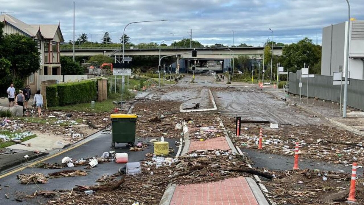
‘Never before seen’: 15k homes flooded, evacuations, CBD inundated, two dead as flood emergency worsens
Schools in ten LGAs across South East Queensland will remain closed tomorrow as authorities wait for flood waters to recede. It comes as extensive rail damage has caused train services to be suspended tomorrow and ‘possibly longer’.
QLD weather news
Don't miss out on the headlines from QLD weather news. Followed categories will be added to My News.
Schools across South East Queensland will remain closed tomorrow as flood water subsides and assessments are set to be carried out.
As the storm cell moves further south selected state schools on the Sunshine Coast, Noosa and Lockyer Valley Local Government Areas will begin to reopen.
This excludes the four following Fraser Coast schools which will also remain closed tomorrow: Mungar State School, Maryborough Central State School, St Helens State School, and Granville State School.
Education Minister Grace Grace said a variety of factors will determine which schools can reopen.
“Our absolute highest priority is the safety of our students, staff, and families,” Minister Grace said.
“As floodwaters recede and we can conduct damage assessments and ensure safe transport, more schools will be able to open.
“Across the 10 LGAs where all schools will remain closed, there will be very limited public transport and travelling by road may be dangerous.
“This means while the school site itself may be safe to open, we do not want people out on the streets trying to get to schools when that could be dangerous.”
LGAs with school closures:
Brisbane City Council
Ipswich City Council
Moreton Bay Regional Council
Somerset Regional Council
City of Gold Coast Council
Logan City Council
Redland City Council
Scenic Rim Regional Council
Gympie Regional Council
Cherbourg Aboriginal Shire Council
Minister Grace encouraged families to check the Queensland school closure website which will have each school closure listed on the site – including state, catholic and independent schools.
“I also urge parents, families and children to not take risks, and be especially cautious around floodwater, or swift flowing water,” she said.
“Please ensure children understand the dangers of floodwaters and do not play near storm drains or causeways during this heavy rain.
“Stay safe and remember – if it’s flooded, forget it.”

Seqwater released a statement that said all recreation areas would be closed until further notice “to allow a thorough safety assessment of recreation facilities, water quality and environmental changes caused by the current weather event.”
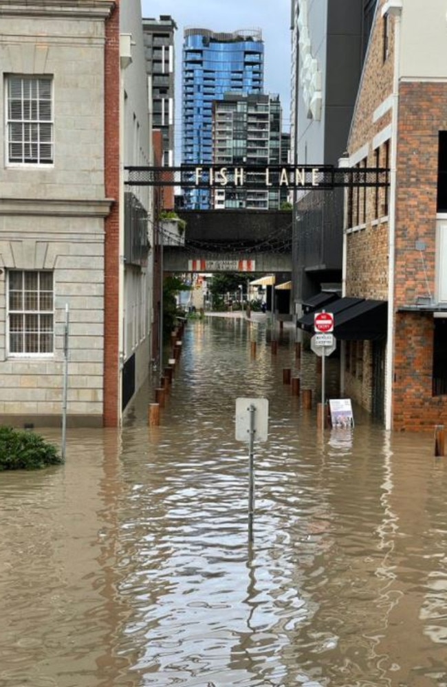
With hundreds of roads closed across South East Queensland, including the Warrego Highway and Ipswich Motorway, access to a number of Brisbane suburbs has been cut.
Transport and Main Roads Minister Mark Bailey said Queensland Rail crews had been inspecting the rail network today, discovering extensive damage to stations, track and overhead electrical wiring at a number of locations.
“Queensland Rail services will remain suspended tomorrow (Tuesday) and possibly longer, due to extensive damage to the network,” Mr Bailey said.
“Safety is paramount, so we will not be resuming train services until it is absolutely safe to do so.”
Mr Bailey said a “limited” number of buses would run on Tuesday but urged customers to check the TransLink journey planner for up to date information.

“It is good news that some Brisbane buses will resume tomorrow but bus services continue to be disrupted due to rising flood waters and road closures in place,” he said.
“With schools closed today and SEQ residents urged to work from home, we believe the impacts of these reduced services has been lessened.
“If it’s not safe for our buses and trains to be operating, it’s certainly not safe for cars to be on the road.
Ferries on the Brisbane River will remain suspended while river levels are high.
School bus services will run to schools that are open and where it is safe to do so, should schools open tomorrow. Parents and students should contact their local school bus operator for service information.
Chief Superintendent and Commander of State Operations at QFES, Brad Commens, said it is increasingly frustrating seeing people risk their lives by driving into floodwaters and getting trapped.
“This event is tipped to be in excess of Tropical Storm Debbie and Tropical Storm Osbourne. This is major, one we haven’t seen for a number of years,” Mr Commens said.
“People may think if they have a 4WD or ute that they can drive through the water, but they just don’t know what is under the water.”
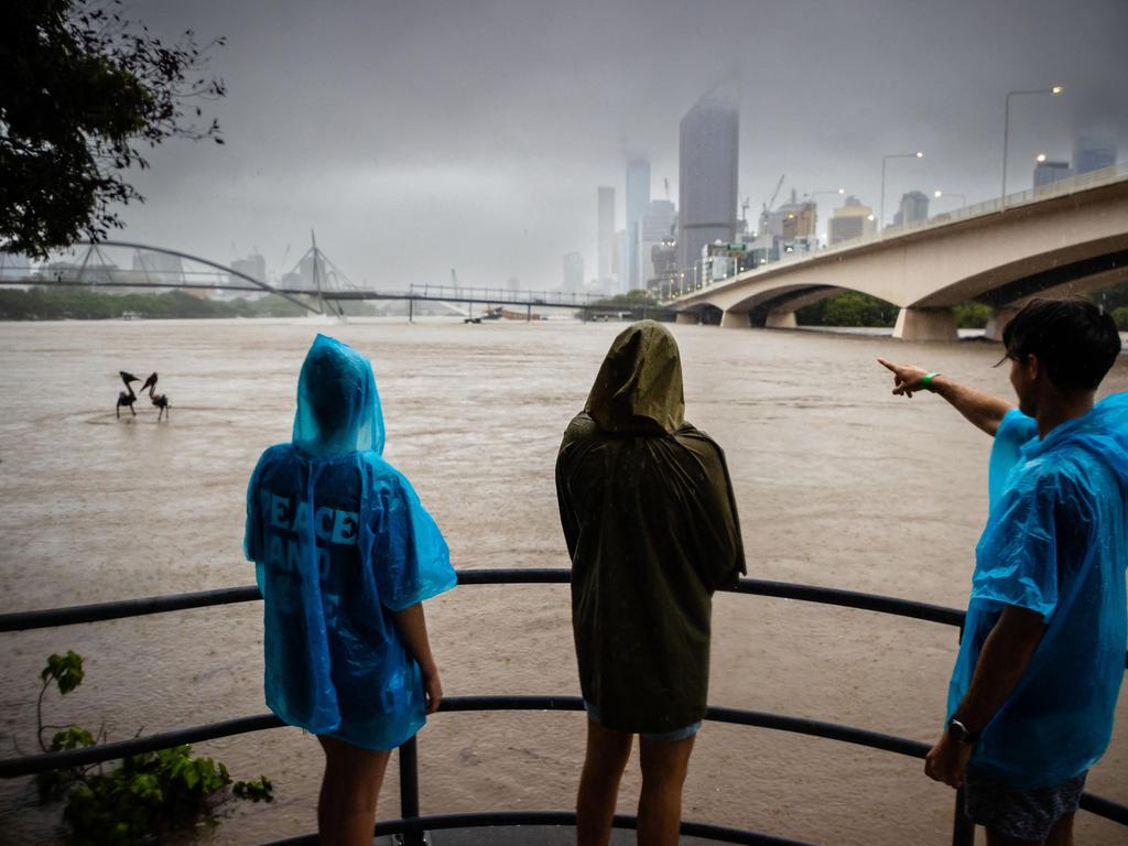
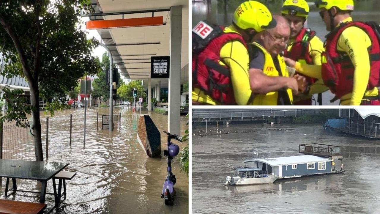
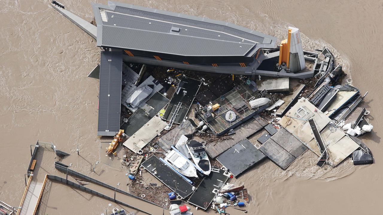
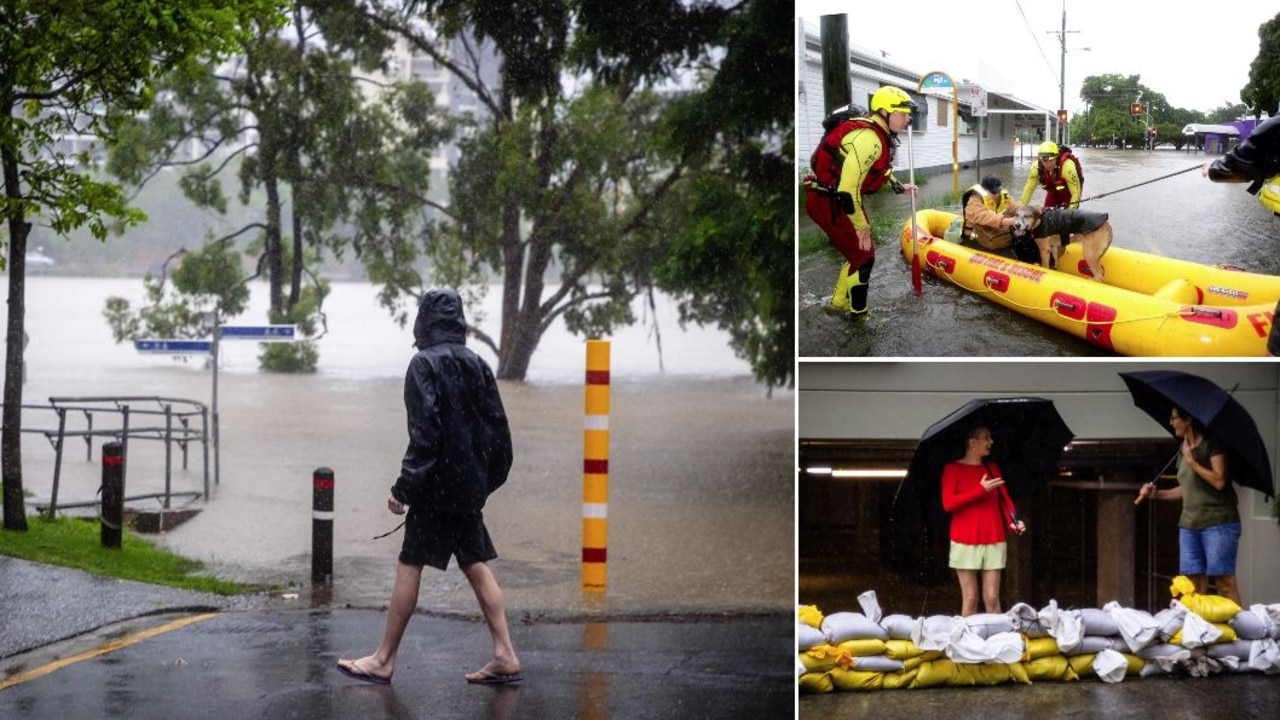
An evacuation alert has been issued by the Queensland Police Service for people at Howard Smith Wharves and the riverside walkway as southeast Queensland’s flooding disaster continues to wreak havoc.
A pontoon has broken free from its anchorage and is carrying a crane.
Those at the Howard Smith Wharves, riverside walkway or surrounding areas have been urged to evacuate the area immediately.
The pedestrian lanes of the Story Bridge have been roped off and people told to move away from the waters edge.
.
A police helicopter circling overhead has blasted emergency warnings to onlookers at the Kangaroo Point side of the river to stay away from the edge.
The pontoon was seen moving slightly, but has so far remained behind the ferry terminal.
The police currently have the crane under surveillance.
A police spokesperson said QPS would be prepared to shut down the Story Bridge if necessary but at the moment the situation doesn’t appear to be getting any better or worse.
Queensland police have also asked locals not to visit either the City Botanic Gardens or Captain Bourke Park.
Hundreds of houses on the northern Gold Coast are still bracing for levels of flooding not seen since Cyclone Debbie tore through the region five years ago.
Flood modelling suggests hundreds of properties in the Gold Coast’s northern regions could be affected by flooding with the risk not expected to abate until Tuesday afternoon.
High tide about 10am Tuesday is the greatest threat as water continues to gush down from hinterland creeks and streams towards the Albert and Logan rivers.
Gold Coast mayor Tom Tate also warned motorists ignoring road closures, or deliberately moving barricades to plough through flooded roads, that they could face hefty penalties.
“What those people don’t know is that we have CCTV cameras now in some of these places that have captured (footage) and I will be forwarding that to the Queensland Police Service when the disaster has subsided,” he said.
The flood modelling is conservative, estimating a 25 per cent chance that properties will be impacted to varying degrees.

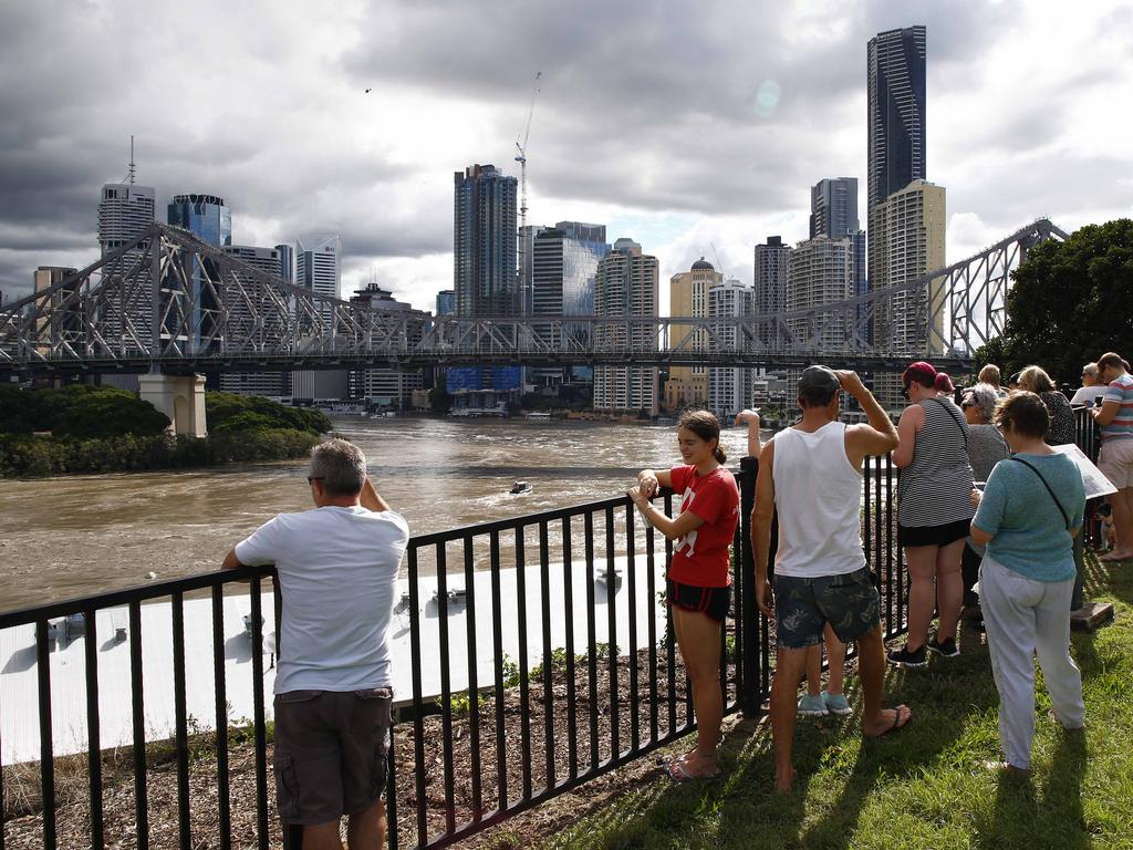
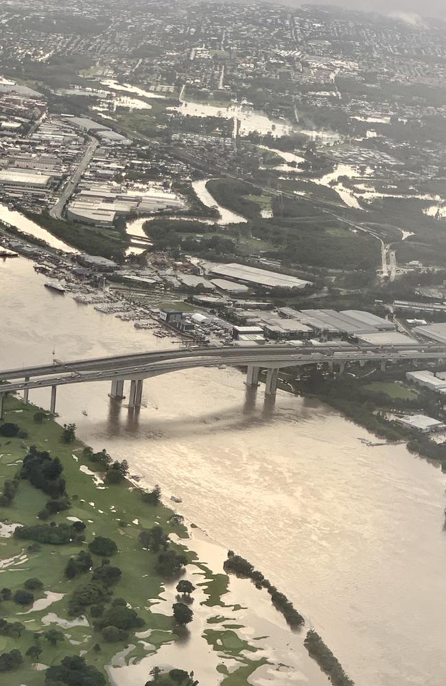
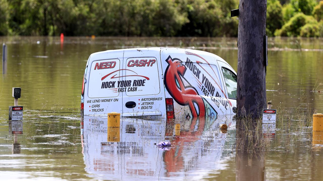
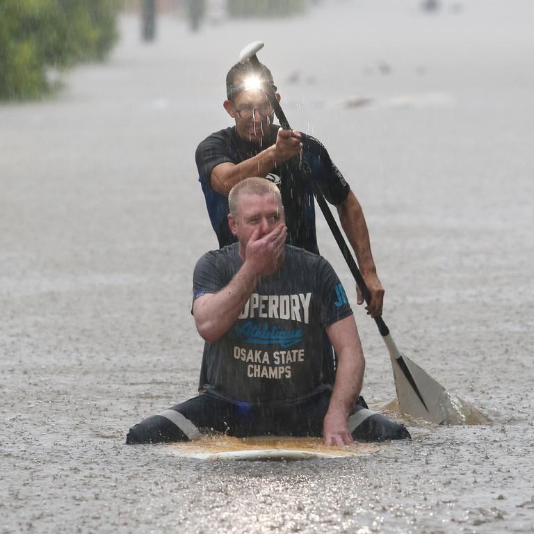
Dramatic rescues have unfolded, 15,000 homes are flooded along with Brisbane’s CBD, two men are dead and at least four more are missing and unmanned houseboats are floating down the raging Brisbane River.
Shelves have been stripped bare at grocery stores as panic buying and logistic snags caused by the flooding impact supplies.

The Sherwood Woolworths had been almost completely stripped of fresh fruits and vegetables.
The store was also running low on bread, meat and eggs.
Shelves were also bare at Coles Ascot on Monday after flooded roads prevented deliveries of fresh produce and bread.
A Coles spokesperson said the supermarket giant was working hard with its transport and supplier partners to reroute deliveries impacted by road and rail closures. The spokesperson said it had temporarily closed a small number of stores as flooding and heavy rain has made it difficult to safely access or operate sites.
“Our team members have been working hard to keep our stores open and stocked for customers in Queensland and Northern NSW,” she said.
The flood swollen Brisbane River has reached major flood level at just under 4m this morning, putting hundreds of suburbs at threat, with two more peaks expected over the next 24 hours.
The M1 is closed while the Bruce Highway between Brsbane and the Sunshine Coast reopened at 1230pm, 1,500 people are in evacuation centres and more than 53,000 homes are without power.

Authorities say the ‘unpredictable and extraordinary’ weather event was one ‘never seen before’ with up to 1500mm falling in some locations in the past few days – equal to a year’s worth of rain.
The BOM’s Diana Eadie said Mt Glorious had recorded 1.5m of rain across the weather event – its average annual rainfall is 1600mm.
“There have been in excess of 700mm in 24 hours at other locations … the significance of this event can’t be understated,” she said.
Premier Annastacia Palaszczuk said it was a ‘never before seen’ weather event.
“This was an unpredictable rain bomb across entire southeast Queensland,” she said.
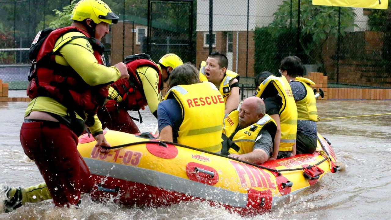
It comes as an elderly man was rescued from floodwaters at Yatala on the northern Gold Coast.
A man, believed to be a local, attempted to head to the motorway in his vehicle, but found himself stuck in rising waters about 9.10am.
He abandoned his ute and tried to walk out, but was swept away in flood waters, just metres from the M1.
A swift water rescue team were able to get to him within minutes and use an inflatable boat go get him to safety.

Popular restaurants in Brisbane’s CBD have been inundated by floodwaters and there are long check-in delays at Brisbane Airport due to staff resourcing issues. Passengers are advised to arrive at least 90 minutes before their flight.
The iconic yellow umbrellas of Riverbar and Kitchen have almost been swallowed entirely by polluted river water pouring through Opa Bar and down past Massimo.
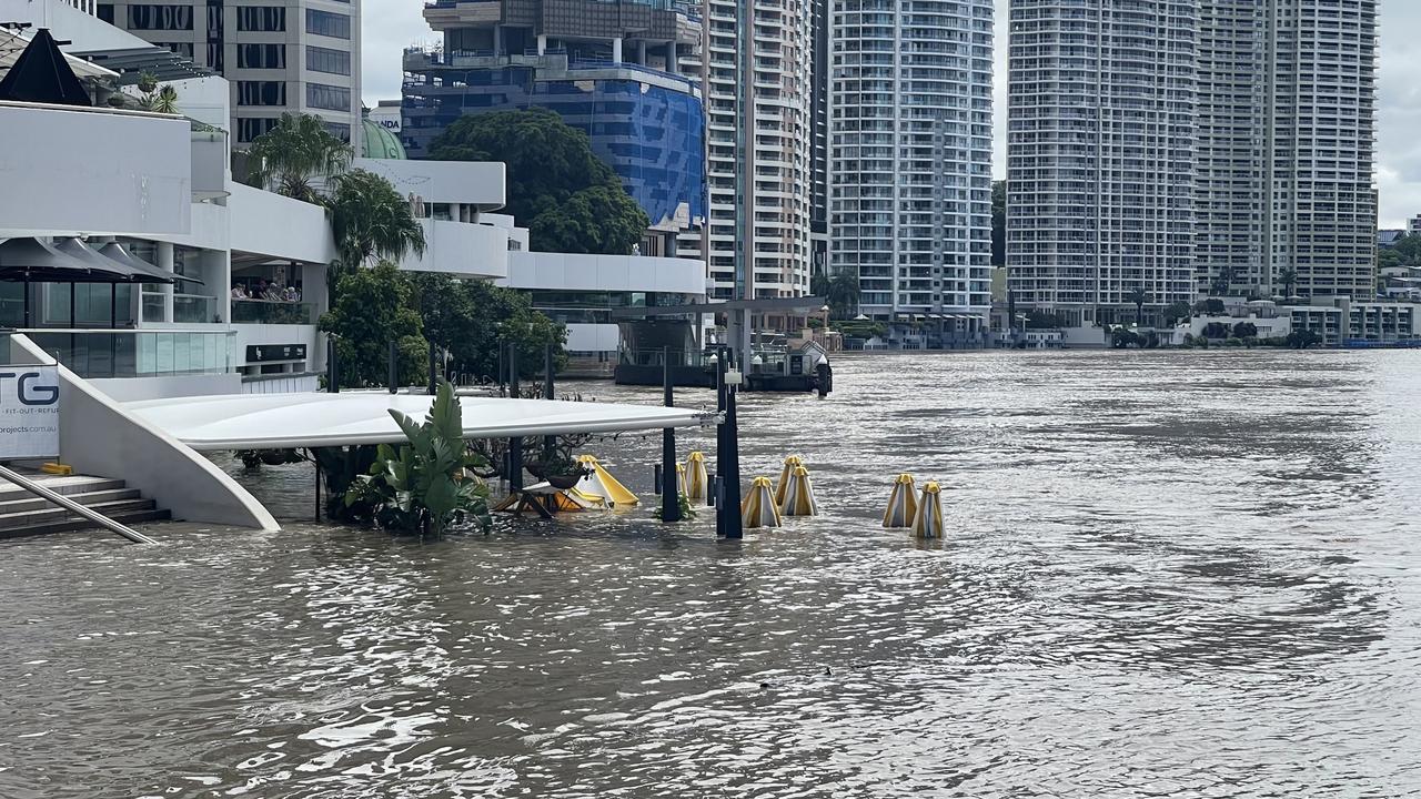
Riverside Ferry Terminal is underwater as debris laps at the doors of some of Brisbane’s most renowned waterfront restaurants.
The Kookaburra Showboat Cruise office is nowhere to be seen as the river reaches just a few steps below Mr and Mrs G.
A spokesman for Destination Brisbane Consortium which is delivering Queen’s Wharf said they were monitoring the situation.
“The foreshore area including the river walk has been inundated but is designed to flood and wash down,” he said.
“Our flood management plan has also prevented any significant inflows into the main resort basement levels.
“The Neville Bonner Bridge structure has not been impacted though a number of temporary piles were pushed over due to debris over the weekend and will be retrieved when the river returns to normal flow.”
Ms Palaszczuk said it was an 'unpredictable and extraordinary weather event’ very similar to ex-Cyclone Oswald and ex-Cyclone Debbie … and it wasn’t over yet with the rain still pommeling the southern Gold Coast.
An immediate warning for a severe thunderstorm has been issued for Gold Coast’s south with the possibility of flash flooding in Coolangatta.
The area was severely affected by heavy rainfall on Sunday and another intense storm front was approaching the coastline in Southeast Queensland before 11am, where it was expected to hit Coolangatta and continue inland over the NSW border, according to the Bureau of Meteorology.
There are currently nearly two dozen warnings in Queensland as the southeast manages an ongoing flooding emergency on the Brisbane River and surrounding waterways.
âš ï¸â›ˆï¸Severe thunderstorm warning issued for #SEQ: Heavy rainfall that may lead to flash flooding is likely. Area includes #Coolangatta. #QldFloods Details: https://t.co/CinugnxqkN@QldFESpic.twitter.com/ReCNFoFLW2
— Bureau of Meteorology, Queensland (@BOM_Qld) February 28, 2022
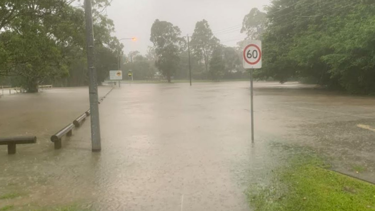
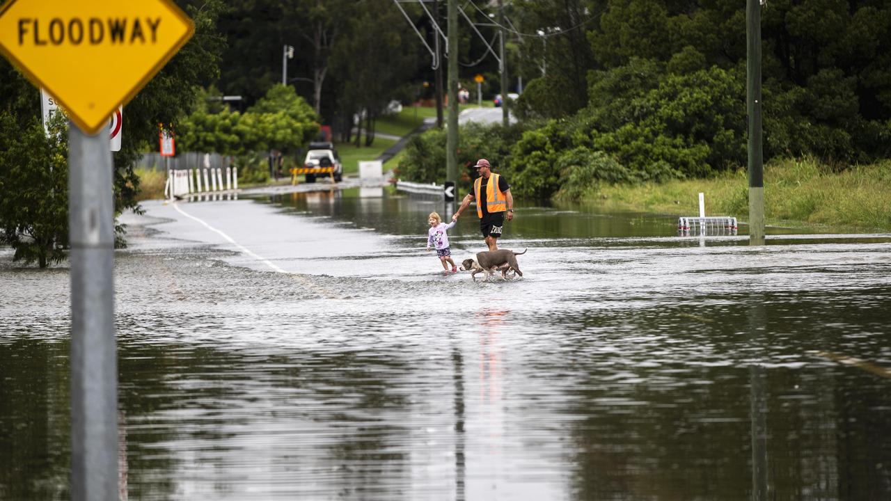
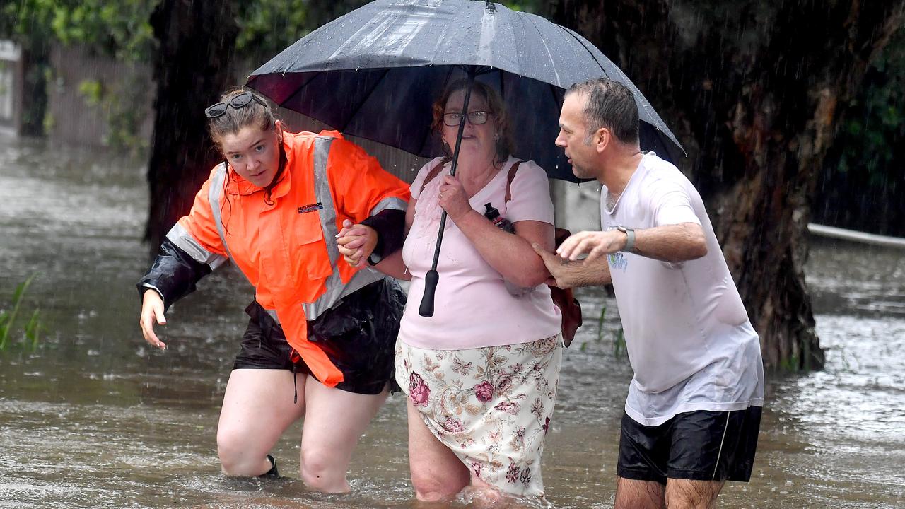
Queenslanders in flood zones have been told to stay home, with water levels expected to rise over the coming days as a deadly and fierce weather system begins to move south.

QFES made 101 swift water rescues and SES responded to 2187 calls for help from residents affected by floodwaters between 3pm on Sunday to 5am Monday.
Queensland’s death toll from the devastating rain event rose to eight, following the death of a man in Fitzgibbon in Brisbane’s north and another man at Currumbin Valley.
A man, believed to be aged in his 50s, has died after his car was washed away in floodwaters in the Currumbin Valley in the early hours of this morning.
Around 3am police were called after reports of a car in trouble in waters over Currumbin Creek Road near Stackpole Street.
The vehicle was believed to have been driven 30 to 40 metres into flood waters.

Police and a swift water rescue team attended but were unable to locate the vehicle.
Surf Life Saving Queensland were called to utilise an inflatable rescue boat in the search and located a vehicle submerged around 10 metres from the roadway around 10.45am.
A man and a dog were located deceased in the vehicle a short time later.
A report will be prepared for the Coroner.
Senior Sergeant Rob Finlay, of Coolangatta police, said the man’s death was a tragedy.
He said the man had gone to a house in the area to move his car from rising floodwaters in the early hours of Thursday when he veered off Currumbin Creek Rd into Currumbin Creek.
“All the roads in this area were inundated at the time,” he said.
“It was very early in the morning so people can get disorientated. Police were made aware (of the man’s disappearance) by a call to Triple 0 this morning.
“Unfortunately, the deceased had a dog with him in the vehicle which is sad as well.”
In the Fitzgibbon tragedy, the 59-year-old man is believed to have been pinned against a fence by raging floodwaters, but despite rescue efforts from neighbours he was unable to be saved.
Two residents raised the alarm after the man from Carseldine was swept away in floodwaters and pinned against a fence near Cabbage Tree Creek about 4.15pm.
The pair went to the man’s aid and performed CPR but tragically he died at the scene.
Just 18 hours after the tragedy, sticks, logs and other debris were the only signs of how high the floodwaters had risen.

Residents told The Courier Mail the water had come up quickly.
It was a hair-raising night for residents at Golden Downs retirement village, that backs onto Cabbage Tree Creek.
Trish Vass, 81, said one resident tripped and fell off his balcony and had to be rescued from the floodwaters by other residents.
“It’s never come up that high, ever,” she said.
“And I’ve been here coming up 22 years this year.”
A man missing from Goodna – Cameron Rodgers – has miraculously been found alive.
The man’s car has been parked at a local train station since yesterday and no one had seen or heard from him since – sparking fears for his safety.
Mr Rodger’s sister told the Today Show he had parked his car at the train station to meet with a friend before disappearing.
He was found alive about lunch time.

A second man is missing off the Brisbane Valley Highway at Glen Esk from where he called for help to say he was trapped in his car. There is so far no sign of his vehicle or him.
Police have confirmed they are searching for a 76-year-old man missing in flood waters near Paddy Gully Greek.
A vehicle in flood waters on the Brisbane Valley Highway was reported to police at 9pm on Sunday. Police, SES and swift water rescue were unable to locate the man following a search.
The search is continuing.
‘NEVER BEFORE SEEN’ RAIN BOMB DUMPS ‘YEAR’S WORTH OF RAIN:
Premier Annastacia Palaszczuk – at a press conference this morning – confirmed the Fitzgibbon death saying ‘from the outset can I say that tragically one further life has been lost’.
She said the weather event was an 'extraordinary weather event’ very similar to ex-Cyclone Oswald and ex-Cyclone Debbie and it was pushing down through Logan and the Gold Coast and causing havoc now in northern NSW.
“We’ve been through a lot together,” she said to Queenslanders.
“We’ve been through the Covid pandemic of two years and now we’re going through yet another flood.
“And many people will have been impacted, not once, not twice, but maybe even three times.”
She said although it was not like the 2011 floods, it was still a “significant event”.

The Premier said no one had seen this much rain over such a period of time in the southeast catchment area before.
The SES received 2,200 requests for assistance overnight.
QFES is currently involved in a number of rescue operations throughout the region and carried out over 113 water rescues overnight.

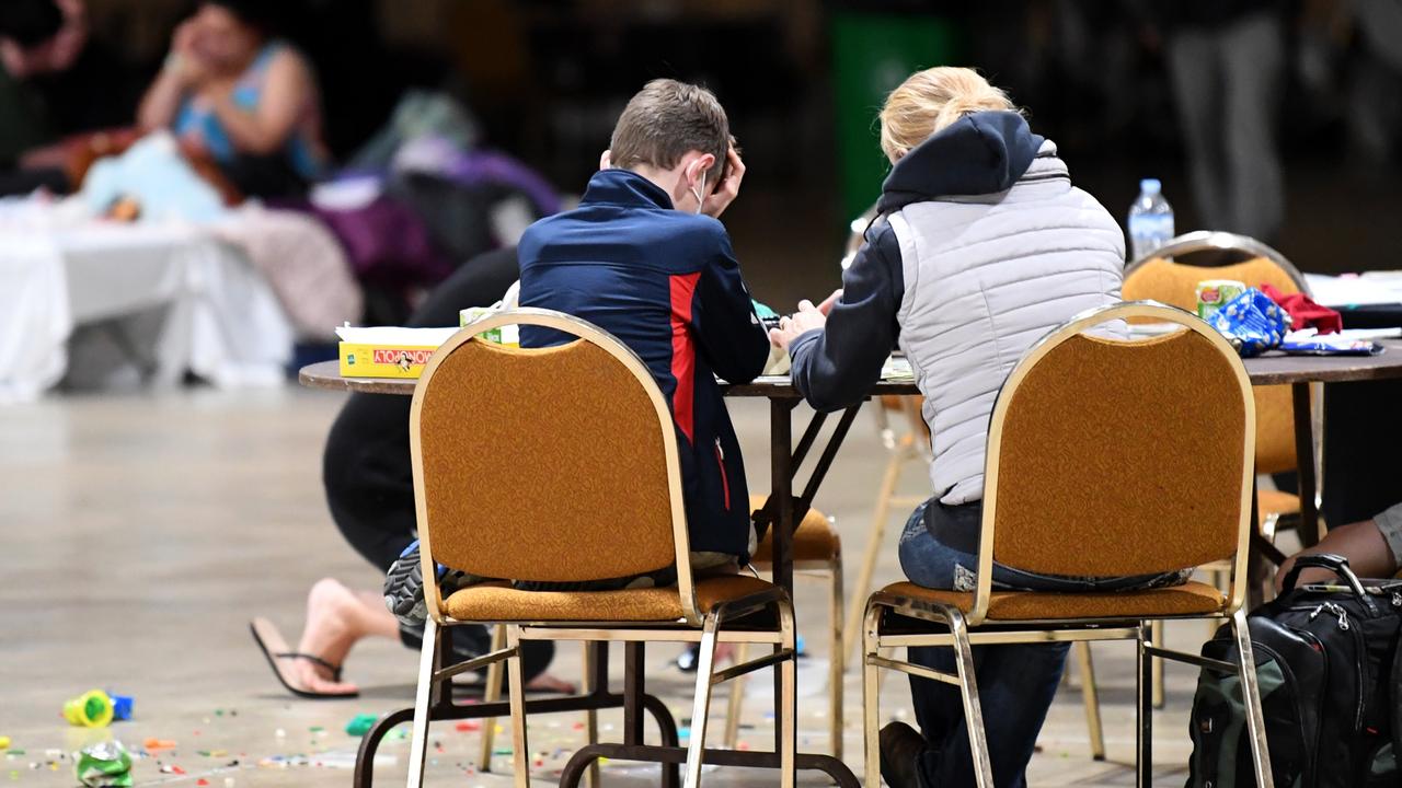
Ms Palaszczuk said evacuation centres were available, with estimates of up to 15,000 homes impacted in Brisbane.
The Mount Crosby Water Treatment Plant is operating at a reduced capacity, with Seqwater working to get it back to normal operations.
Seqwater has confirmed in a tweet that “the drinking water being supplied IS SAFE TO DRINK,” but continues to ask people to conserve their water usage as they work to manage water supply.
TransLink has announced that the 620 and 622 bus routes from Maroochydore to Noosa will return to normal scheduling.
TransLink have also reiterated that buses will not replace trains following the suspension of those services due to flooding and power outages.
Queensland Police Service recently updated motorists on traffic diversions in the Brisbane CBD.

Part of Coronation Drive remains blocked off with the Brisbane River flooding a 50 metre section near the Regatta Hotel.
The water is about knee deep having receded from waist height this morning.
It is expected to rise again later today.
“I reckon it will be higher because you’ve got the high tide and the releases (from Wivenhoe Dam) they did yesterday,” Mark who lives in Park Lane said.
Scores of residents without power are walking down Coronation Dr carrying ice.
“I’ve heard it said that once you lose power that’s it until it stops flooding,” Mark said.
“So probably three days.”
Traffic heading from the Riverside Expressway on to Coronation Drive will be directed towards the on ramp at Hale Street.
Motorists will be diverted to Cribb Street in Milton if they’re travelling from Toowong.
Diversions are also in place for Hale Street, with those travelling inbound from the Normanby Fiveways set to be directed towards the on ramp at Caxton Street.
Motorists will also not be able to turn left onto Milton Road and will instead be directed to Petrie Terrace.
Margaret St is also closed between George St and Edward St.
Officials will be carrying out rapid assessments as they prepare to gear up for the recovery.
About 2000 defence personnel will also be deployed to help with the response.
The weather bureau says the most intense rainfall has now eased in southeast Queensland.
But the risk for significant flooding is still very real.
“But that really intense rain is now shifting into northern NSW and easing from much of southeast Queensland,” said Bureau of Meteorology’s Diana Eadie.
She said Mt Glorious had recorded 1.5m of rain across the weather event – its average annual rainfall is 1600mm.
“There have been in excess of 700mm in 24 hours at other locations … the significance of this event can’t be understated,” she said.
Premier Annastacia Palaszczuk said it was a ‘never before seen’ weather event.
“This was an unpredictable rain bomb across entire southeast Queensland,” she said.
She denied she had played down the threat of the system on Saturday, declaring even the BOM had not anticipated such significant rainfall.
“If they’ve never seen it before you can’t expect the officials to have seen it before,” she said.
“It has been fast, it has been furious and it has had a big impact.
“This is mother nature – I can’t control mother nature.
“It is tough, it is heartbreaking – but it is mother nature.”
The Brisbane River has reached 3.85m during the high tide this morning, but a second peak of 3.3m could be experienced at 8pm tonight.
Ms Eadie said there was the potential for “another significant peak” on Tuesday morning about 9am for the Brisbane River at about 3.7m – just above the major level.

She said moderate flood levels for the Brisbane River could continue for much of the week.
The moderate level is below 3.5m.
“We’re expecting moderate flood levels to persist along the Brisbane River, again, that will be associated with the high tides.
“So the larger peaks will be occurring in the morning.”
Ms Eadie said severe thunderstorms could return from Wednesday but ‘we’re not expecting widespread rain that we’ve seen this time’.
The Albert River had seen major flooding and the risk of flooding in a large parts of the southeast had not subsided despite the rainfall passing.
In Gympie the flood has peaked and is slowly subsiding, turning the focus of authorities to downstream Maryborough. The town could reach 10.7m, similar to the 2013 floods.
The Ipswich area has seen 17m of flooding, with river levels in Logan to potentially reach those that were experienced in ex-Tropical Cyclone Debbie.
Ms Eadie said the forecast was more settled going on this week.

She said there was a return of potential damaging thunderstorms from Wednesday onwards.
There were not forecasts for widespread rain, as had been experienced over the past few days, but there was potential for “very intense rainfall rates in some localised areas”, Ms Eadie said.
Ms Palaszczuk said the Bruce Highway is expected to reopen later today and a decision on school openings for tomorrow would be made later today.
“We will try to get schools open as quickly as we can,” she said.
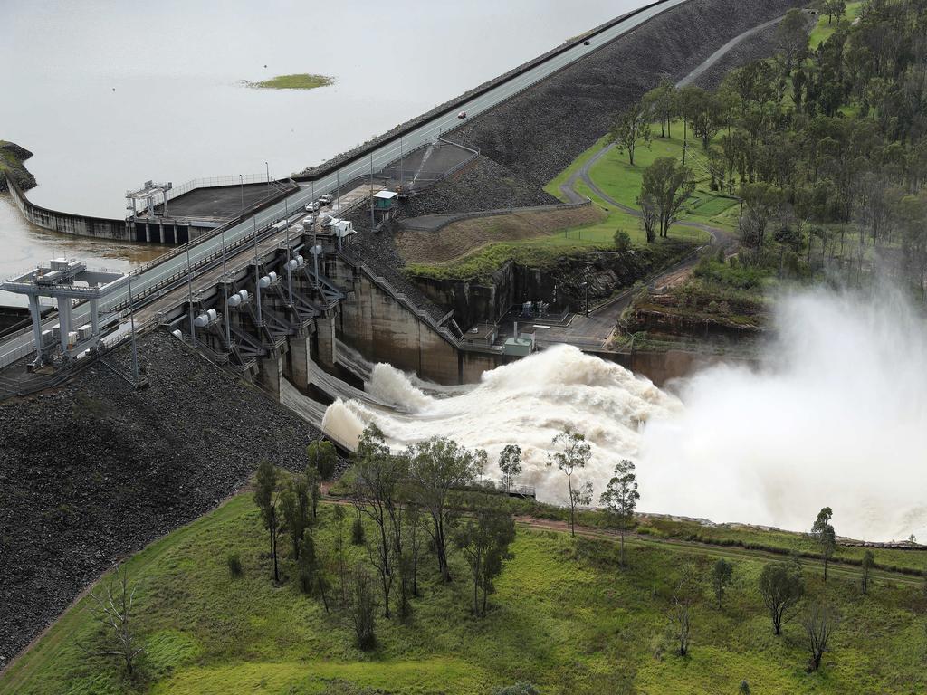
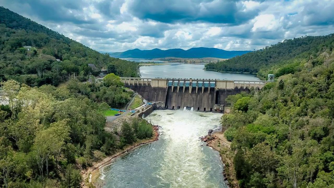
Releases from Wivenhoe would continue and reporters were told it was working as intended with inflows peaking last night.

Department of Water Director-General Graham Fraine said rainfall over catchments had eased.
Wivenhoe Dam is at 182 per cent, slightly below the 185 per cent.
“It is a sign Wivenhoe Dam has performed as it was designed to do,” he said.
He said the dam had effectively held back a significant amount more than it had let out.
“If Wivenhoe Dam wasn’t here then certainly the flooding which unfortunately we’re experiencing in Brisbane would be worse,” he said.
There are 20 ungated dams spilling.
People are asked to continue conserving water with the major Mount Crosby Water Treatment plant operating at a reduced capacity.
Southeast Queensland’s water consumption has fallen 20 per cent since authorities asked the region to conserve water.
Seqwater’s Mike Foster said inflows into Wivenhoe Dam peaked on Sunday evening.
He said Wivenhoe and Somerset had collectively held back about 2.2m megalitres of water.
There has been about 150,000 megalitres of water released.
“That’s the dam doing what it’s supposed to do, reduce those natural flows,” he said.
Mr Foster said authorities would attempt to empty the flood water storage compartment over the next seven days through controlled releases.
“Flows will certainly not impact flooding,” he said.
Mr Foster said when the weather event started on Thursday, Wivenhoe Dam “was a little over half of its drinking water capacity”.
“We had that available and the full flood storage compartment available – a very large space,” he said.
He said controlled releases had “allowed us not to exacerbate those floods downstream”.
Mr Foster acknowledged the releases would cause some homes to be flooded for longer.
“We acknowledge that we’re in the wet season so we certainly need to have that fully available,” he said of the surplus flood capacity.
He was asked why authorities could not hold off on releases until after flood water subsided.
“Mother Nature has taught us many things and Mother Nature can change really quickly,” he said.
“ … We need to ensure that the dam is ready to deal with another event because things can happen quickly.”
Ms Palaszczuk said the dam was at 39 per cent in November and water restrictions were being considered.
She said the capacity had jumped from 58 per cent to more than 180 per cent in several days.
Ms Palaszczuk said dam operators were following the manual of operations and issuing controlled releases.
“They are looking at the forecast but they are also looking at what’s happening on the ground,” Ms Palaszczuk.
The Bureau of Meteorology said moderate flooding could continue to occur for much of the week during associated high tides.
Deputy Commissioner Steve Gollschewski said the recovery would begin during the day.
Officials are expecting many thousands of properties in Brisbane to be impacted.
There are currently over 1500 people in evacuation centres throughout the southeast region.
Mr Gollschewski said all people who had gotten themselves into trouble had been in places where they should not have been.
He said people could expect extended power outages, but authorities were working very hard to bring power back on as soon as possible.
Mr Gollschewski said Maryborough would hit a “fairly significant peak” and services were being restored in Gympie.
The ADF’s air fleet has also dropped supplies to isolated communities.
He said he understood people were keen to begin the clean up but authorities were still dealing with the emergency situation and people should not be going to assess their homes.
“People should not go into floodwaters,” he said.
“It’s been disappointing and we’re seeing imagery all the time … of people going into flood waters.”

That included people padding on boats “for a lark”, which was very disappointing, he said.
He said power was turned off to thousands of homes, largely because of the danger of the flooding.
He said people should be relying on official emergency channels for their advice and they had a responsibility to be informed.
Police Commissioner Katarina Carrol said a seventh death had been recorded – a man who had been swept up in flood waters.
“We do have a number of other people that we hold great concerns for,” she said.
She praised all police, SES volunteers, QFES, the ADF and even members of the public who had been involved in rescues.
She said there were still a great number of roads cut off around Brisbane and people should avoid travel at this time.
QFES Commissioner Greg Leach said last night was the busiest night for rescues, with 113 calls for assistance.
He said interstate colleagues had contacted the QFES to offer assistance should Queensland need it and there were a number of swiftwater technicians already helping from Victoria.
“We have significant activity happening down through the Gold Coast and Beenleigh at the moment,” he said.
Transport Minister Mark Bailey said the Mt Lindsay Highway was cut at Beaudesert Road and Jimboomba and a number of exits off the M1 were cut, including exits 87 and 89.
The Cunningham and D’Aguilar highways also remain cut, he said.
He said road crews were out assessing the Bruce Highway to decide whether it could be reopened later today.
He said the Wulkuraka rail yards at Ipswich were flooded, where the NGR trains are based, and there were flooding impacts on the whole electrical network.
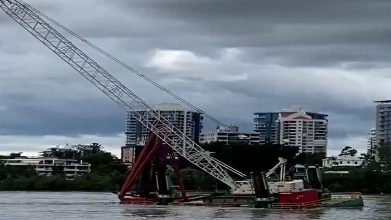
Quick thinking Brisbane maritime workers helped avert a potentially dangerous on-water incident when an oil tanker slipped its moorings and started drifting down river at the height of the deluge on Monday morning.
Maritime Services Queensland said rising floodwaters caused the CSC Friendship, a 185m Hong Kong-flagged tanker, to break away from the Ampol Products wharf at Lytton around 12.30am.
Maritime Services Queensland general manager Kell Dillon said the vessel drifted and grounded downstream about 12.40am.
“A marine pilot boarded the vessel and confirmed no water ingress or apparent pollution,” said Mr Dillon.
The vessel was refloated safely about 5.45am and will be moved to Moreton Bay anchorage for further. There were no injuries or pollution from the incident.
The port said it is working on a plan with the Regional Harbour Master to remove large pieces of debris floating down the river and impacting waterside infrastructure.
Brisbane’s largest fresh produce market is shut until further notice as flood levels impact the Rocklea site.
Brisbane Market said a flood peak of 8m was expected on Monday morning, around 1m lower than the 2011 floods.

“We have personnel on site who have implemented our flood management plan to ensure that critical services and infrastructure can be reinstated once flood waters start to recede,” a spokesperson said.
Brisbane Lord Mayor Adrian Schrinner confirmed the council would need time to get the full picture of how many homes had been impacted by the flood.
He said at least 2100 properties had been fully submerged and a further 10,000 partially impacted — but this applied only to those impacted by river flooding.
“What these figures don’t include is the other properties that have been impacted by creek flooding over recent days because we’ve seen flash flooding in various areas, creeks have risen up really quickly and they’ve gone down again,” Cr Schrinner said.
“And so to get the full picture will take a little bit longer in terms of all the properties that have been impacted.”
MORE DETAILS OF HOW DISASTER HAS HIT:
The M1 has been cut at Tallebudgera, Burleigh and Jacobs Well due to flooding as intense rainfall hits the Gold Coast while Steve Irwin Way is also closed from Glenview to Beerburrum. Long delays are expected.
The Bruce Highway is still cut between Caboolture and Caloundra and the Warrego Highway is closed at Blacksoil because of floodwaters.
Diversions are in place.
On the Gold Coast, 70 roads have been closed due to flooding, 2500 homes are without power, all beaches are closed and the SES is attending to almost 20 calls for help.
Mayor Tom Tate said the city’s south was the biggest concern.
“Our focus is on the two valleys (Tallebudgera and Currumbin) as well as the Logan and Albert region to our north. Flash flooding can still occur,” he said.
“SES, police and all other agencies are on the ground in those areas assisting people.
“We await low tide at around 2pm today (Seaway) as that may start to flush out some of the rivers and give us some reprieve but the peak for the northern rivers will not be until tomorrow morning.”
Electricity has been cut to more than 53,000 homes around South East Queensland, with Brisbane, Ipswich, Gympie and Logan the worst affected.

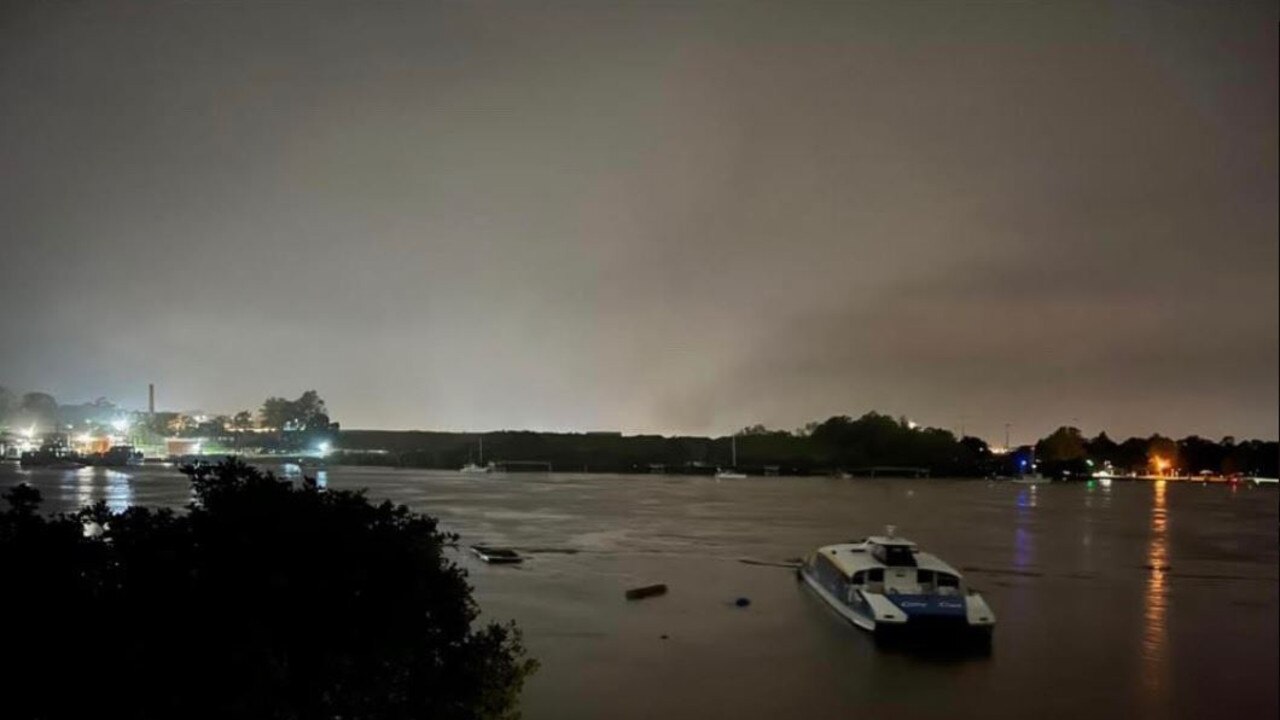
There are reports one of Brisbane’s CityCat ferries, that was berthed at Hamilton Northshore, was dislodged by river debris and was on its way downstream.
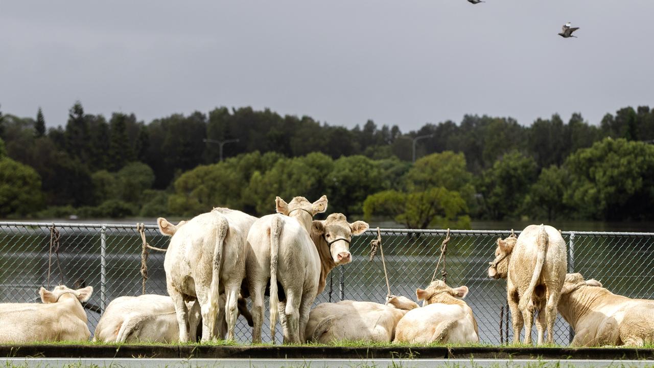
Meanwhile, the infamous Carrara cows are being moved to higher ground, with the large paddock on the edge of Clear Island Waters completely inundated with flood water.
Dozens of cows could this morning be seen being herded up busy Gooding Drv at Carrara.
A man can be seen carrying a calf on his back in a video posted to the Carrara Community Group Notice Board on Facebook
The plea from Premier Annastacia Palaszczuk to stay home came as the state’s southeast was battered by another day of relentless rain, extreme storm activity and flash flooding.
The Brisbane River was expected to reach major flood, peaking at 4m, with the morning high tide, less than half a metre shy of the 2011 Brisbane flood peak.
A second peak on the afternoon high tide around 3.3m is likely and river levels are not expected to drop below moderate flood level for at least a few days.
Queensland Fire and Emergency Services last night issued an emergency flood alert for 140 Brisbane suburbs which include Acacia Ridge, Ascot, Bowen Hills, Brisbane City, Carindale, Indooroopilly, Kangaroo Point, Lutwyche, Nudgee, Paddington, Rocklea, St Lucia, Taringa, Wavell Heights and Wynnum.
The Mary, Noosa, Bremer, Logan, Albert, Condamine and Balonne Rivers are also all under major flood alert.
An emergency alert has also been issued for:
– Residents of Tingalpa in Brisbane’s east and Boondall in the north, residents of Sandgate, and for the area around Brisbane Airport and Park Ridge and Beenleigh.
– Residents of the Currumbin and Tallebudgera valleys warned of ‘intense rainfall leading to dangerous and life-threatening flash flooding’ with the area cut off, said the warning texted to residents at 4.18am. The Tallebudgera and Currumbin creeks have risen sharply as the high tide nears just before 6.30am, and low-lying residents are on high alert.
Emergency alerts have also been issued for Loganholme, Dalby and the Gold Coast.
The Myall Creek at Dalby is expected to reach above moderate levels this afternoon.
– Logan residents in the Logan River catchment with Maclean Bridge expected to peak 1.5m above 2017 level. Waterford expected to peak 1.5m above 2017 level.
– Logan residents in the Albert River catchment with flooding forecast to approach 2017 flood levels. Wolfdene to peak mid Monday just below 2017 level. Beenleigh to peak Monday evening around 1m below 2017 level.
– Moreton Bay residents in White Patch, Bribie Island where water supply has been cut due to a section of road and water pipe washing away on White Patch Esplanade. Unitywater, Council, SES and Volunteer Marine Rescue are working to get bottled water and other supplies to affected people.
– Authorities issued an emergency alert at 11.15 for northern Gold Coast, with flooding to occur at Ormeau from the Albert River and Logan River catchments.
Queensland Fire and Emergency Services issued the alert on Tuesday morning, warning the two rivers will peak at 2017 flood levels.
“Residents need to prepare and act accordingly,” the authority posted on Facebook. “Do not enter flood waters, stay informed and monitor conditions.”
Impact of overnight rain felt
The wild weather continued overnight, with heavy rainfall and flash flooding extending down to the Gold Coast as the weather system tracks southward along the coast and into northeastern NSW.
Intense local rainfalls of up to 180mm are possible, along with wind gusts in excess of 90km/h in the Gold Coast hinterland.
Bracken Ridge recorded the most rain in the past day with 444mm in the 19 hours to 4am Monday with 421mm at Albany Ck, 409mm at Everton Hills, 408mm at Murrumba Downs, 401mm at Lawnton and 389mm at Upper Springbrook.
The death toll from the catastrophic floods now stands at seven, with Queensland Fire and Emergency Services taking 1500 calls for help from Brisbane to Beaudesert on Sunday.
About1000 schools will be closed on Monday, trains have been cancelled and people have been urged to work from home and drive only if it is an emergency.
The Royal Brisbane and Women’s Hospital has suspended appointments and planned care temporarily because of the ongoing rain and flooding.
Roads remained cut across the southeast, including the Bruce Highway at Caboolture, the Warrego Highway at Gatton and many major and minor roads throughout Greater Brisbane.
In the city’s inner suburbs, swiftwater rescue crews helped trapped residents from their waterlogged homes in scenes reminiscent of the 2011 floods.
In Windsor, locals used surfboards and inflatable mattresses to get themselves, their pets and their belongings to safety, while on the Brisbane River a miraculous rescue unfolded when a houseboat collided with the Holman St ferry terminal at Kangaroo Point and capsized.
A man on board was pulled from the water by members of the public as the wreckage jammed into a pontoon at Howard Smith Wharves.
There were also reports of manhole covers lifting due to the volume of water in drains, with incidents at Russell Street, Cleveland; Abelia Street, Alexandra Hills; Dorsal Drive, Birkdale; Birkdale Road, Birkdale; Gowan Road, Sunnybank Hills and Thomas Street, Bundamba.
“No one expected this rain bomb to be sitting over the southeast of our state for such a long period of time,” Ms Palaszczuk said.
“Let me be very clear about this – this is like an unpredictable cyclone and it is the levels that we have never expected or could never have been forecast,” she said.
“We never expected this rain, this rain bomb is just unrelenting. It’s coming down in buckets – it’s not a waterfall, it’s like waves of water just coming down,” Ms Palaszczuk said.
She said anyone who lived by a river or creek prone to flooding should think about getting out and moving to higher ground.
“Now is probably the time to start thinking about your safety plan,” she said.
There would be controlled water releases over the coming days from the three gated dams, including Wivenhoe Dam, but she insisted it still had capacity to hold more water.
Ms Palaszczuk agreed that an extreme weather event had been forecast, but said “we didn’t expect it to stay this long”.
“I don’t control the weather, with all due respect,” she said, when probed further by journalists.
“For the next 24 hours, we do expect the rain to be easing.
“But of course, that doesn’t mean we’re out of the woods, because we’re going to see these high levels for the next three days, especially around the Bremer (River), the Brisbane River, and also down to the Logan, the Albert, and there could be some flash flooding as well.”
Meanwhile, Police Commissioner Katarina Carroll urged people to stay out of the water, warning they were putting themselves – and rescue crews – in grave danger.
“Thankfully, there haven’t been any more deaths in addition to the six that I reported this morning,” she said.
“I want people to speak to their friends, speak to their children about this behaviour please.
“There are people on surfboards, people swimming, people trying to cross waterways and the list goes on.”
She said police had 6000 jobs logged in just two days relating to people entering floodwaters.
“In addition to that, there has been another 1000 calls just in the last several hours,” she said.
“I ask all of you that you take this seriously, that you stay off the roads unless you desperately have to be on them for an emergency matter,” Ms Carroll said.
Queensland Fire and Emergency Services have responded to 6500 calls for help throughout the flood event.
The majority of the calls on Sunday came from Brisbane, as well as Logan, Ipswich and Beaudesert.
The Bureau of Meteorology recorded some startling rainfall totals, including 135mm in just 90 minutes at Kippa Ring and 52mm in 30 minutes at Murrumba Downs.
In Ashgrove, Debbie and Paul Edwards were rescued by a swift water crew, after water inundated their home.
“It was like a river running through the house,” Mr Edwards said.
In Windsor, a Ukrainian couple were rescued after having to shelter on top of their dining room table as water levels rose within their home.
“It’s pretty life-threatening for her now,” Katrina Murphy, as her friend Iryna remained trapped on the table.
“They called for a rescue, but were told to sit tight because the water wasn’t flowing.”
RAINFALL TOTALS:
Rainfall since 9am Sunday to 4am Monday:
444mm at Bracken Ridge Res
421mm at Albany Ck
409mm at Everton Hills
408mm at Murrumba Downs
401mm at Lawnton
389mm Upper Springbrook
Previous Rainfall to 9am Sunday:
461mm at Mount Glorious
362mm at Rose Ck Road
322mm at Mount Mee
320.8mm at Beerburrum
231mm at Brisbane City
Previous Rainfall to 9am Saturday:
709mm at Mt Glorious
541mm at Pomona
444mm at Tin Can Bay
381mm at Dayboro
301mm at Gatton
236mm at Brisbane City
224mm at Ipswich
FULL LIST OF SUBURBS UNDER THREAT FROM BRISBANE RIVER FLOOD:
Acacia Ridge
Albion
Algester
Annerley
Anstead
Archerfield
Ascot
Ashgrove
Auchenflower
Balmoral
Banyo
Bardon
Bellbowrie
Belmont
Boondall
Bowen Hills
Bracken Ridge
Brighton
Brisbane Airport
Brisbane City
Brookfield
Bulimba
Calamvale
Camp Hill
Cannon Hill
Carina
Carindale
Chapel Hill
Chelmer
Chuwar
Clayfield
Coopers Plains
Coorparoo
Corinda Darra
Deagon
Doolandella
Durack
Dutton Park
Eagle Farm
East Brisbane
Ellen Grove
Fairfield
Fig Tree Pocket
Fitzgibbon
Forest Lake
Fortitude Valley
Geebung
Graceville
Greenslopes
Gumdale
Hamilton
Hawthorne
Heathwood
Hemmant
Hendra
Herston
Highgate Hill
Inala
Indooroopilly
Jamboree Heights
Jindalee
Kangaroo Point
Karana Downs
Kelvin Grove
Kenmore
Kenmore Hills
Kholo
Lake Manchester
Larapinta
Lutwyche
Lytton
Manly West
Middle Park
Milton
Moggill
Moorooka
Morningside
Mount Crosby
Mt Ommaney
Murarrie
Nathan
New Farm
New Market
Newstead
Norman Park
Northgate
Nudgee
Nudgee Beach
Nundah
Oxley
Paddington
Pallara
Parkinson
Petrie Terrace
Pinjarra Hills
Pinkenba
Port of Brisbane
Pullenvale
Red Hill
Richlands
Riverhills
Rocklea
Salisbury
Sandgate
Seven Hills
Seventeen Mile Rocks
Sherwood
Shornecliffe
Sinnamon Park
South Brisbane
Spring Hill
St Lucia
Stones Corner
Sumner
Sunnybank
Taigum
Taringa
Tarragindi
Teneriffe
Tennyson
Tingalpa
Toowong
Virginia
Wacol
Wakerly
Wavell Heights
Westend
West Lake
Willawong
Wilston
Windsor
Woolloongabba
Wooloowin
Wynnum
Wynnum West
Yeerongpilly
Yeronga
Zillmere


Join the conversation

Storm shield: How AI will protect our state of disaster
Queensland has secured world-first AI storm detection technology in a $3m partnership between Suncorp and the state government to revolutionise natural disaster response.
Read more

Hail, rain, wind, SNOW: Winter storm on Qld collision course
A rare winter storm threatens to dump 15cm of snow on Queensland's Granite Belt this weekend as forecasters warn of an incoming polar air mass.
Read more