
Qld beaches closed as cyclone swell pounds coast
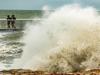
At least five people have been stranded by rising floodwaters and dozens of beaches have been closed as big swells from Tropical Cyclone Seth pound the coast. LATEST WEATHER UPDATES
QLD weather news
Don't miss out on the headlines from QLD weather news. Followed categories will be added to My News.
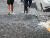
At least five people have been stranded by floodwaters north of Brisbane and all Gold Coast beaches from Burleigh to Southport and 14 Sunshine Coast beaches have been closed as big swells from Tropical Cyclone Seth pound the coast.
Emergency services were called to McNamara Rd at Rocksberg, east of Caboolture, just before midday to reports that multiple vehicles and at least five people were stranded by flood waters.
A Queensland Fire and Emergency Service spokeswoman said there were three points where the road crossed the Caboolture River and the cars had become “stuck between the first and second crossings”.

The Rescue 500 helicopter was tasked to take a swift water rescue team in to help the stranded motorists but the spokeswoman said nobody was injured or at risk.
After being stranded for four hours, a QFES spokeswoman said that the river had subsided by 4pm and all five vehicles were able to drive across safely.
Several roads across the southeast were closed due to flash flooding, including Buchanan Rd at Morayfield, Kirri Ave at Petrie, Mott St at Brendale and Strong Rd at Rush Creek.
Ten southeast Queensland dams were spilling over as a week of rain and showers continued, with the southeast’s combined dams level sitting at 63.5 per cent.
Flash flooding has led to road closures in parts of #SEQ. Please check your route before you leave home and remember if it’s flooded, forget it. https://t.co/19vlrmCKBXpic.twitter.com/sCtDSAZCM3
— RACQ (@RACQOfficial) January 1, 2022
Gold Coast City Council has opened sandbagging stations in anticipation of flash flooding.
These stations - at 232 Old Pacific Highway at Pimpama, 46 Boyd St at Tugun and 61 Hutchinson St at Burleigh Heads - will operate from 4.30pm-7pm on Saturday and 6am-10am and 3pm-7pm on Sunday.
Gold Coast Mayor Tom Tate said his council was doing flood modelling and preparing to activate the city’s Disaster Management Centre if conditions worsened in the next 48 hours.
“Mother Nature being unpredictable, Seth could turn and say hello to the Gold Coast and if that happens, we’ve got to brace ourselves for a cyclone,” he said.
He warned locals and tourists against venturing into the pounding surf, suggesting they should ‘go bowling’ instead..
“You can be a strong swimmer but it’s nasty out there,” he said.
“If the lifeguard says don’t do it, don’t get in the water. The surf is very risky.”
Surf Life Saving Queensland duty officer Brenden Scoffell warned there was already “a lot of water moving about.”
“People should definitely not swim at closed beaches and exercise extreme caution on those that are open.”
Mr Scoffell said showery conditions were keeping New Year’s Day beach crowds at bay and there were no reported rescues so far.
He said the cyclone swell was expected to peak on Sunday afternoon or Monday morning, with 4-5m waves and a 1.91m king tide.
Tropical Cyclone Seth formed in the Coral Sea northeast of Mackay on Friday, packing wind gusts of 110km/h.
The category 1 storm was forecast to move east southeast away from the coast before tracking south and possibly intensifying on Sunday, before weakening to a subtropical system by Monday.
The BOM said ‘large and powerful surf’ with king tides was developing as Cyclone Seth moved south-east and there was potential for offshore gales.
“Depending on the position and strength of TC Seth, damaging surf and abnormally high tides may impact parts of the southern coastline from Sunday, heightening the risk of coastal erosion,” the bureau said.
It said Seth was expected to weaken on Saturday and move southward well off the Queensland coast.
But it could drift back towards the coast mid next week as a weaker system ‘though (there is a) high degree of uncertainty around exact movements over this period’, the bureau said.

“It’s building quite significantly and will really build into the weekend,” Bureau of Meteorology forecaster Helen Reid said on Friday afternoon.
“People might need to think twice about hitting the beach over the weekend because as well as the large swell, it will also be quite windy.”
Ms Reid said showers were forecast for the first day of 2022 but these would start to ease from Sunday, although winds would stay gusty.
It should be sunnier from Monday, she said, but with still a shower or two predicted for the rest of the week.
Gold Coast Lifeguard Service superintendent Peter Ball said on Friday surf conditions were being closely monitored ‘and if it gets bad, we’ll look at closing beaches’.
Surf Life Saving Queensland Gold Coast supervisor Nathan Fife warned that conditions were ‘pretty rough’ and forecast to get worse.
“Definitely on the open beaches, we’re going to see a lot of rips and water moving around,” he said.
“It’s absolutely critical that people only swim between the flags during patrol hours, and get out of the water as soon as the flags come down for the day. If we can’t see you, we can’t save you.”
Mr Fife also pleaded with people who had been drinking not to enter the surf, creeks, dams or even backyard pools, and to also keep a close eye on children.
“We’ve seen instances in recent weeks where people have taken chances with tragic consequences,” he said.
“We want people to enjoy the new year safely.”
More Coverage
Read related topics:Weather
Join the conversation

City’s coldest June start in 16 years, feels like MINUS 9.8C out west
Southeast Queensland is shivering through its coldest morning in more than 15 years but feels-like temperatures have dropped to insane levels in the southern inland.
Read more
Feels like MINUS 6.5C out west as Brisbane faces brutally cold, windy 24 hours
Residents in parts of southern Queensland have woken to their coldest morning of the year, with temperature dropping below zero in a number of places.
Read more