
Flood maps reveal suburbs in firing line as La Nina flood threat looms
With a potential third La Nina looming for Queensland, authorities are working to avoid a repeat of February’s devastating floods. These are the suburbs most at risk.
QLD weather news
Don't miss out on the headlines from QLD weather news. Followed categories will be added to My News.
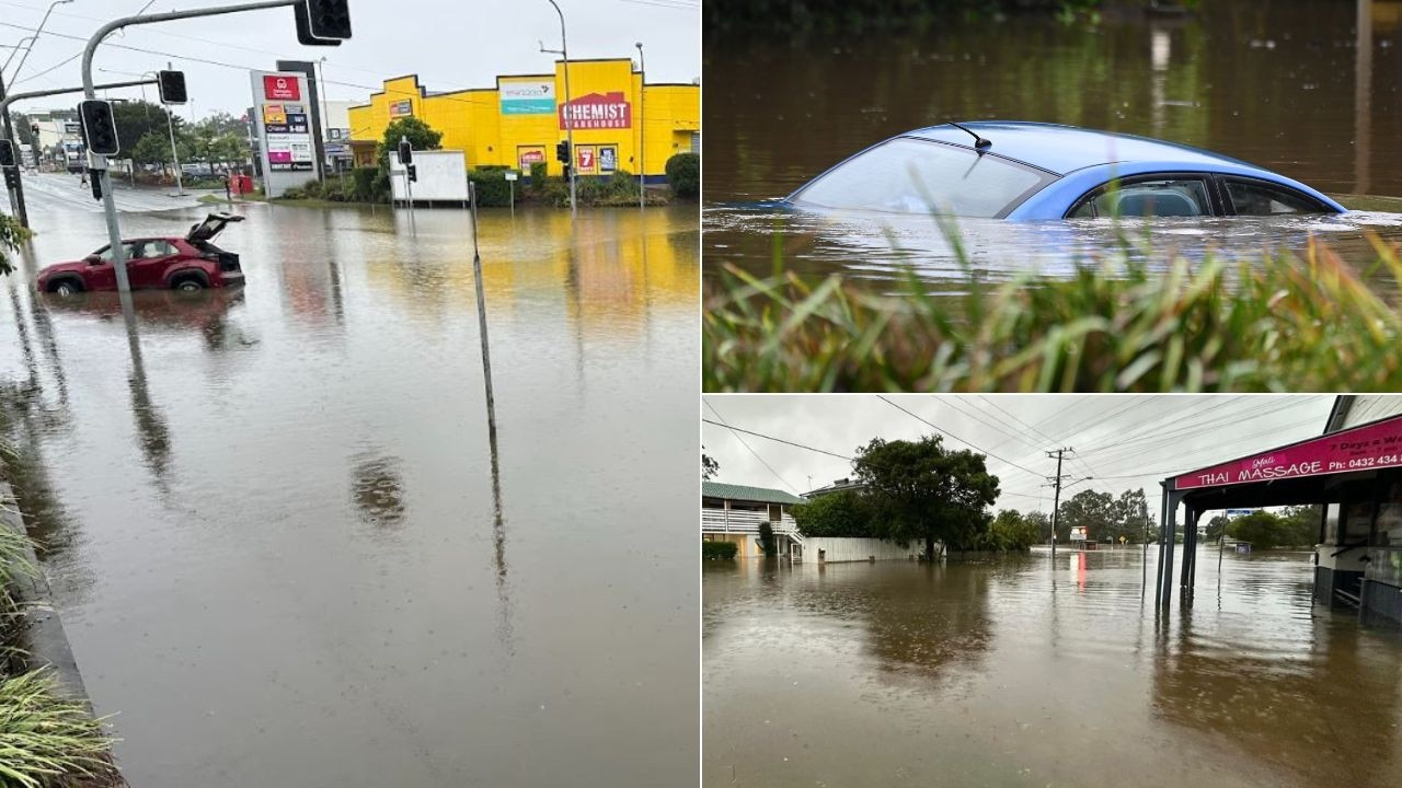
Flood maps across South East Queensland have shown which suburbs could be at risk of further flooding, just months after February’s devastating deluge as a possible third La Nina bears down.
Local councils and state government recovery authorities are working to avoid a repeat of the widespread floods that hit the state from February to April impacting 23 local government areas and affecting more than 500,000 people and around 18,000 homes or businesses, according to a Deloitte report.
The report also found that heavy rainfall and major flooding was widespread across the state from Gladstone to the Gold Coast and west to Balonne.

In Brisbane, Rocklea, Oxley, Virginia, Fitzgibbon and Windsor were the top five suburbs inundated by flooding.
It comes as BOM revealed there was a 70 per cent chance of La Nina forming again, which would increase the chances of above-average rainfall during spring and into summer.
And without a long enough break from the rain, meteorologists have said the soil won’t have enough time to dry out across the state, meaning an increased risk of flooding is on its way if La Nina does develop.
In response to the previous floods, the Queensland Government has put $224m into disaster recovery and resilience grants for councils, state agencies, and organisations.
As a part of the funding, property valuations for the Resilient Homes Fund voluntary buy back program have already started in Goodna and Ipswich.
Meanwhile, local council flood maps across the south east have highlighted which suburbs could be at risk based on historical flooding, however some have now reviewed previous plans in light of February’s floods.

For instance, Logan City Council said the council’s maps will be updated next month, with “significant changes expected” to the extent of the properties affected by flood hazards.
Brisbane
For Brisbane City Council, three forms of flood maps show where at-risk suburbs are in relation to the Brisbane River flood planning, creek or waterway flood planning and overland flow flood planning.
In the river’s map, most suburbs on the Brisbane river are at high risk of flooding including parts of Jindalee and Wacol, with southern suburbs from Graceville to Rocklea, Oxley and Archerfield experiencing the most of it.

Meanwhile, with creek and overland flow, parts of Bald Hills, Nudgee, Northgate, Windsor, Rocklea, Carina, Murarrie, Oxley, Durack and Chandler could be impacted with flooding.
Brisbane City Council is currently working to implement a 51-point plan to ensure the entire region can endure future severe weather events, according to Civic Cabinet Chair for Infrastructure, Andrew Wines.
“This includes things such as investigating alternative sandbag distribution locations, removing timber bridges to deliver more resilient structures and relocating essential electrical infrastructure for our traffic signals and public lighting,” he said.

Also as a part of the plan, three timber pedestrian bridges in Seven Hills, Westlake and Sinnamon Park are currently being replaced, and Shorncliffe Escarpment is being reviewed to prioritise backflow devices.
Additionally, the council is managing 48 landslip sites at locations such as waterways, creeks and embankments with works scheduled to remediate all of the areas, including eight that have already been assessed and completed.
Kedron Brook land slips are also being managed under a separate restoration program.
More details here
Sunshine Coast
On the Sunshine Coast riverine flooding and storm tide flooding both pose a risk to coastal suburbs.
For storm tide flooding, suburbs from Coolum Beach down to Maroochydore and inland to Bli Bli and Valdora would be at risk, as well as Caloundra to Thooloora Island and inland past Coochin Creek.

Meanwhile, the risk of extreme riverine flooding is much more widespread impacting the coastal suburbs including Coolum, Marcoola, Golden Beach and Pelican Waters, as well as inland including Coochin Creek, Bli Bli, Maroochy River, Kenilworth, Obi Obi and Glass House Mountains.

The Sunshine Coast Council Local Disaster Management Group participated in a simulated severe weather exercise this month to further prepare for incoming flooding.
“Ensuring the LDMG’s skills are up to date means we can best support and protect the Sunshine Coast during all aspects of a disaster, from preparedness to response and recovery,” a spokeswoman said.
More details here
Lockyer Valley
The Lockyer Valley recently updated their flood maps earlier this year after the devastating floods in Laidley.
Northern suburbs of the Laidley Shire are at the highest risk of flooding according to the latest studies, with a medium to low risk running through the centre of the shire.

Lockyer Valley Regional Council Mayor Tanya Milligan said the council is reviewing plans, preparations and responses to find opportunities for improvements.
“It’s the plans we make before disaster strikes that make the difference during an event which is why residents and businesses are urged to ensure they have the necessary precautions in place to keep themselves, and their families safe – with our website providing tips and tricks on ways to prepare for all weather events,” Ms Milligan said.
More details here
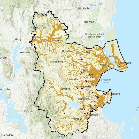
Moreton Bay
In Moreton Bay, high risk flooding could hit north east of Beachmere more predominantly just before going into parts of Caboolture.
Meanwhile, Woodford, Stony Creek and the land between Clontarf and Murrumba Downs would all also be impacted.
Moreton Bay Mayor Peter Flannery said the council had already done a “huge amount of work” after the last major flooding event.
Mr Flannery said there would be increased storm drain checks to ensure pipes were free flowing and not blocked, an additional 60,000 sand bags arriving in the coming months, ongoing maintenance at foreshore locations to protect dunes, monitoring of large trees, and patching works on roads to reduce the likelihood of potholes reforming.
More details here
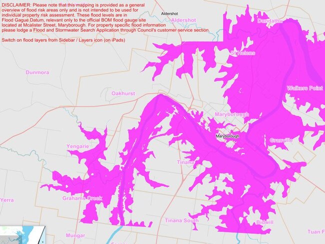
Fraser Coast
In Maryborough, at the Macalister St Gauge peak, flooding could happen through Granville, Walkers Point, St Helens, Prawle and Grahams Creek.
Fraser Coast Mayor George Seymour said the council is preparing for heavy rainfall to cyclones and storm surges to potentially impact coastal communities.
He said the disaster management plan was constantly reviewed and had changes to the plan including reviewing communications workflow for social media, adding to the flood procedure manuals, greater communications to businesses in impacted area and greater mapping for damage assessments.
“Staff will also participate in a regular training session to install the temporary flood levee in Maryborough to ensure we are ready to deploy the structure if needed,” he said.
More details here
Not over yet: Flood sirens sounding, as huge clean-up begins
As the waters begin to recede and the massive clean-up job begins in some parts, a town smashed by floods in 2011 is once again in the firing line as Alfred’s aftermath rolls on.
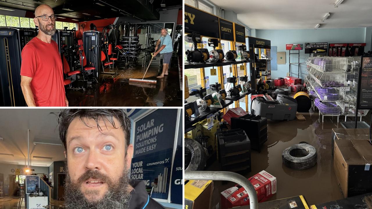
Cruel irony of business which lost everything in history-making flood
A Sunshine Coast business which was selling equipment to fight Qld’s massive floods has become the victim of it while another has dodged a bullet with more than $250k of new equipment spared. VIDEO, PHOTOS