
‘Remarkable’ cold front to make southeastern Australia feel as cold as July
Despite a warm and sunny start, thunderstorms are forecast to arrive in Brisbane tonight, bringing 30km/h winds and possible showers with severe temperature drops and Ekka-like winds to follow.

QLD weather news
Don't miss out on the headlines from QLD weather news. Followed categories will be added to My News.
Temperatures will start turning today in Queensland ahead of a complicated four-seasons forecast predicted to impact the state this week, with some areas placed on extreme fire alert and others warned of storms and frost.
After what started off as a warm, sunny Monday, thunderstorms are forecast to arrive in Brisbane tonight, bringing 30km/h winds and possible showers.
Similar conditions will be felt in the Gold and Sunshine Coasts with temperatures dropping an average of 10C throughout the entire lower half of the state tomorrow.
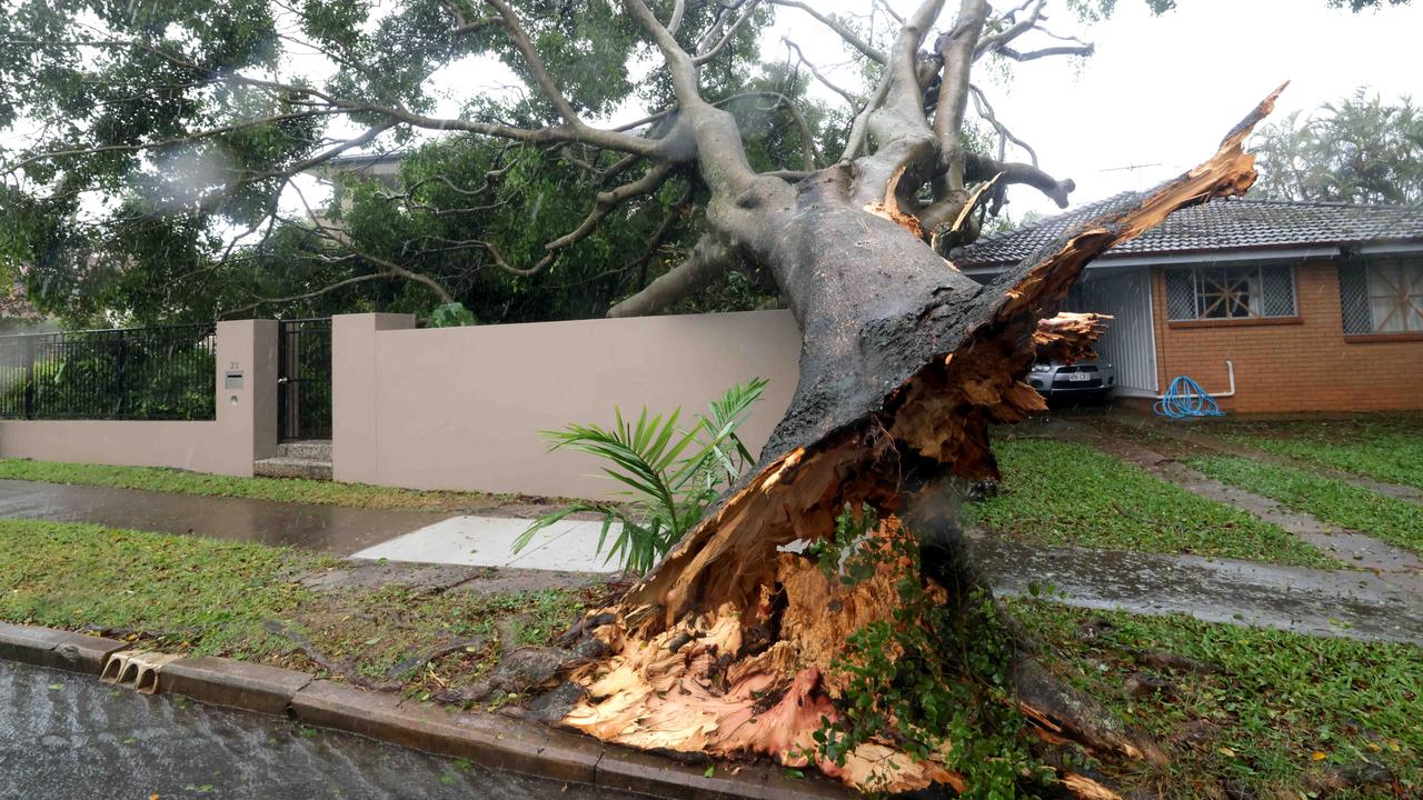
Wet and windy conditions are expected to last into Tuesday’s Melbourne Cup celebrations, with up to 30mm forecast to fall in Brisbane, 20mm in both the Gold and Sunshine Coasts and 40mm in the Darling Downs region.

Bureau meteorologist Livio Regano said a large trough will impact the majority of the state on Tuesday followed by a sharply westerly wind change on Wednesday.
“It’s already raining now across the deep interior -Cunnamulla and places south of Charleville- that will spread more this afternoon, reaching the Darling Downs tonight and possibly brining a rogue storm into South East Queensland tonight,” he said.
“Particularly around the Darling Downs we could be getting 20-40mm and there will be severe storms embedded within the event as well, so some places could see 60-70mm in smaller areas, a little less falling on the coast.

“Tomorrow the thick of the rainband will come through all of eastern Queensland, the Great Dividing Range, and all the way up to Cairns, almost everywhere will be affected by this trough.”
The trough is then expected to contract north during Tuesday evening, moving the storm threat to central and northeastern parts of the state.
The Bureau of Meteorology has warned producers and graziers in the Granite Belt and Darling Downs district of the potential for frost from Tuesday morning -an abnormal weather occurrence during October.
Exposed lambs and sheep are a risk of cold temperatures, showers and the icy westerly winds created by the trough as it tracks north throughout Tuesday and Wednesday.
“Once the band comes through on Wednesday there will be a sharp change to the westerly wind, a much cooler wind like the traditional EKKA westerly’s,” Mr Regano said.

“It’ll be felt mostly on the Darling Downs … but once the change goes through it’ll dry up quickly, possibly leaving lambs and sheep wet and cold so that’s why we have that warning out as well.
“This change is not too unusual for Spring. We’ll notice it more coming off the back of a very hot stretch.
“Where places are sitting at 40 degrees today they should see early 30s tomorrow, so you wouldn’t call it cool, but it’s cooler.”
According to Weatherzone, the incoming weather front is ‘remarkable’.
“The scale of this thing is enormous. It’s a huge pool of cold Antarctic air being hurled northwards by a deep low pressure system near Tasmania, and it’s going to make much of southeastern Australia feel as cold as the bitterest day in July,” the site states.
“Strong cold fronts are not unknown outside of winter in our southern states, but this one really is remarkable for both its strength and its duration, with chilly weather likely to set in for at least a couple of days.”

Sunny conditions are expected to return to the South East on Wednesday however, cool south-westerly winds will linger until Thursday afternoon.
Temperatures are expected to climb back up towards 30C on Thursday and Friday ahead of the weekend.
Meanwhile, an extreme fire danger warning has today been issued for the Channel Country district, with Julia Creek recording its hottest day in October ever.
“We have an extreme fire danger warning out for the Channel Country due to north-northwest winds and temperatures in the 40s, as well as the high vegetation and lack of rain seen in the Channel Country lately,” Mr Regano said.
“Julia Creek broke an October temperature records yesterday, reaching 43.8C and has one final chance to try to beat it again today.”

In the north, Queenslanders will continue sweltering in extreme heatwave conditions today, as residents battle daytime temperatures reaching the high forties and night-time temperatures in the high twenties.
The Bureau has warned locations likely to be impacted by severely hot temperatures include Aurukun, Croydon, Doomadgee, Georgetown, Hope Vale, Ingham, Kowanyama, Normanton and Weipa.
Temperatures are expected to drop dramatically from Thursday onwards as the cool trough moving north begins to cool the atmosphere however, far north areas in the Cape York Peninsula will still experience usual high summer temperatures.
“The heatwave will likely to continue until midweek,” Mr Regano said.
“The first sign of Far North Queensland cooling down is Thursday, when they will probably wake up to cooler morning temperatures because they've been carrying heavy, hot nights.
“Again not exactly a cool change but not as ridiculously hot.”
Severe heatwave warnings remain in place for: Peninsula and Gulf Country, Northern Goldfields and Upper Flinders, North Tropical Coast and Tablelands and Herbert and Lower Burdekin districts.


Cyclone insurance claims soar
More than 31,000 claims were lodged across the southeast after ex-tropical cyclone Alfred dealt widespread damage to thousands of houses, properties and cars. See where the most claims were made.
Roof tearing tornadoes captured by Queensland storm chaser
A Queensland storm chaser has captured remarkable photos of destructive tornadoes that have wreaked havoc across Texas. SEE THE PHOTOS