
Qld weather: BOM issue new severe weather warning for parts of the Sunshine State
Severe weather, including hail and strong winds, has hit parts of Queensland, as the state faces days of flooding rain.
QLD weather news
Don't miss out on the headlines from QLD weather news. Followed categories will be added to My News.
Falls of 88mm have been recorded in parts of the state, after several severe weather warnings were issued in the state’s west on Wednesday.
The Channel Country, Central West, and Maranoa and Warrego districts were warned to expect large hail, flash flooding, and damaging winds just before 7.30pm on Wednesday, with
Quilpie, Eulo and Adavale all in the firing line.
The weather bureau cancelled that warning at 9.30pm.
An earlier severe weather warning for flash flooding in the Warrego and Maranoa districts was cancelled about 7.30pm. It was issued earlier on Wednesday in response to widespread rainfall in excess of 80mm.
The heaviest falls were at Adavale Rd, northwest of Charleville, where 88mm fell in 24 hours, while around 80mm was recorded at two other stations at Upper Quilberry and Loddon.

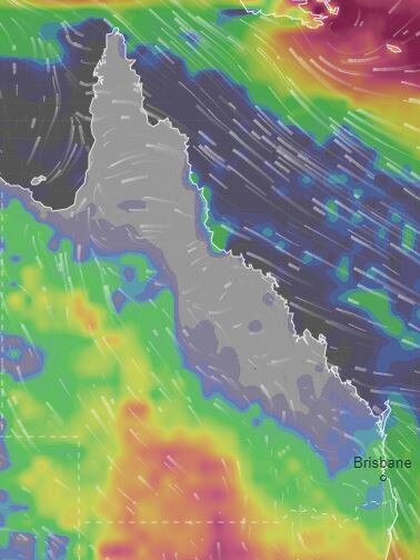
The storms come as a series of low-pressure systems dragging moist tropical air from the Indian Ocean are set to bring days of flooding rain to parts of Queensland.
The multi-day deluge will be accompanied by potential supercell storms and flooding, with both the negative Indian Ocean Dipole and La Nina in full effect.
Sky News Weather meteorologist Alison Osborne said 60-80mm might fall over wide areas during the next few days and up to 150mm in some local deluges.
“That’s over a month’s worth of rain falling in the next three days alone. Some towns inland we’ll see that in under a day.”
The Bureau of Meteorology today issued a severe weather warning for parts of the Central West, Channel Country and Maranoa and Warrego areas.
Twenty-four hour rainfall totals could exceed 100mm.
Issued at 6.07am, the alert warns that heavy rainfall is set to develop this morning over southwest Queensland today, which may lead to flash flooding.
The threat will intensity in the afternoon and early evening.
Localised rainfall totals over 24 hours could possibly reach up to 100mm, while six-hourly totals of 20-40mm are likely.
Areas including Thargomindah, Charleville, Cunnamulla, Quilpie, Isisford and Blackall may be affected by the thunderstorms and heavy rainfall.
The Bureau will issue another severe weather warning update by 11am.
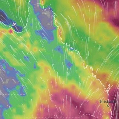
As reported yesterday, a record-breaking rain bomb is forecast to hit large parts of Queensland over the next two weeks, bringing the renewed threat of widespread flooding.
Long-term forecasts are predicting drenching rain every day over the next two weeks before peaking on Saturday, October 15, when more than 30mm is forecast for Brisbane.
Monster supercell storms and intense rain are anticipated to lash most of the east coast.


Monster weather system brings storm, heavy rain to Qld
Brisbane and surrounding parts of the southeast have been hit by storms and heavy rainfall this afternoon as a 3000km-long monster low moves across the state.
Read more

Wild storms, polar blast as 3000km monster low barrels towards Qld
The system, which stretches 3000km from north to south and encompasses 30 per cent of Australia, is forecast to pack a punch when it hits Queensland.
Read more