
Queensland in grip of summer heatwave with temperatures to reach 46C
Temperatures in Queensland are rising, with the mercury climbing beyond 41C in the hottest part of the Outback and Brisbane city edging closer to the forecast maximum of 35C. The heat will continue for days, with little overnight relief in some places.

QLD weather news
Don't miss out on the headlines from QLD weather news. Followed categories will be added to My News.
Birdsville is the hottest place in Queensland as heatwave conditions grip the state, with a warning of little relief in sight - even in the early hours.
But Brisbane is also heating up, climbing above 34C at lunch time, not far off the forecast maximum of 35C.
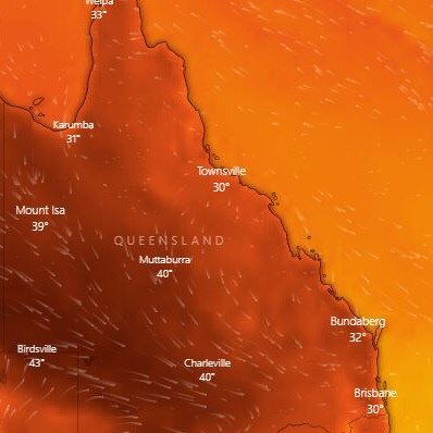
At 12.30, temperatures across the central west and northwest were well over 30C and climbing.
It was 42.2C at Birdsville in the state’s Channel Country at 12.02pm.
At 12.30 it was 41.3. Winton and Longreach were both above 39C.
Across South East Queensland, Beerburrum was 33.8C, Nambour was 33.5C and Coolangatta was 30.4C.
In Brisbane city, the temperature at 12.30 was 34.1C. In Logan, the temperature at Greenbank was 35.4C.
And there’s little reprieve in sight, particularly across the northern interior.
“We’re looking at severe heatwave conditions building across the northern interior, Mount Isa region,” meteorologist Brooke Pagel said.
“They’re going to peak in the low to mid 40s, but their hot temperatures will continue into the weekend.”
Mount Isa’s day time temperatures will sit above 40 all week, building to 44C Sunday.
Nearby Camooweal is set to have three straight days of 45C, while Urandangi’s overnight low Sunday will remain a sweltering 29C.
Southwest communities like St George and Goondiwindi are likely to top 40C on Wednesday, while in the southeast maximums will hover in the mid-30s.
Temperatures are tipped to stay below 40C across the South East, but the forecast is still looking hotter than previously expected, with temps 10 to 15C higher than last week’s daytime maximums.
“Most of South East Queensland is in a low intensity heatwave,” Ms Pagel said.
“It’s around 6 degrees above average in South East areas today; that will peak in the mid to high 30s on Thursday ahead of a cooler change coming through Friday.”
“Gold Coast is spared from most of the heat wave conditions, they’ve got a sea breeze at the moment which is helping keep the temperatures down a little.”
Storms are possible across the Brisbane region as they move from the west, with a chance of severe storms Thursday.
“The main risk of those storms will be damaging wind gusts. We’re meeting northerly winds which have a lot of hot air so there’s potential for some really strong gusts,” Ms Pagel said.
The wind change Thursday night will see temperatures drop for the South East, returning to temperatures in the 20s for Friday and through the weekend.
It could get to 35C in Brisbane today, 33C on Wednesday and 36C on Thursday.
Ipswich will be even hotter, with the daytime maximum likely to be 37C Tuesday, 37C on Wednesday and 38C on Thursday.
The hottest place in Queensland today is likely to be Birdsville, where it will get to 43C today before a sweltering 46C on Wednesday.
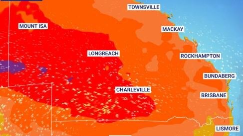
Queensland’s heatwave conditions are being triggered by the departure of a low, which will allow hot air that has been building in the north to sweep south into the state.
“Normally it’s the other way around, you’d get a slow build-up of heat, and then you get a sudden, cool change,” meteorologist Livio Regano said.
“What’s happening here is that for the last several days, our whether has been dominated by this low off the coast. But today is its last day, it’ll push away very, very quickly.”
“This blob of cool air that’s been sitting over Southeast Queensland all this time moves off and gets instantly displaced by a new blob of air coming from the north and it’s a much warmer one.”
Humidity will build through the week, with showers and storms more likely through the weekend.
“Storms arise generally just before a cool change … that’s what will be happening on Thursday night. That will take us into Friday which will be dropping back down to 26 degrees and leading us into a more showery weekend.”
“This coming weekend will be quite similar to the weekend we’ve just had, where it’s a little bit showery, a little bit cloudy, and back to the mid-20s,” Mr Regano said.
CURRENT TEMPS & 7-DAY FORECASTS

Ice ice baby: Spectacular images of unseasonal frost as Qld freezes
Queensland’s overnight temperatures will increase to double digits in the coming days, following the coldest start to winter in 16 years, bringing frost and ice to many regions. SEE THE PHOTOS

City’s coldest June start in 16 years, feels like MINUS 9.8C out west
Southeast Queensland is shivering through its coldest morning in more than 15 years but feels-like temperatures have dropped to insane levels in the southern inland.