
Qld floods: More heavy rain and hail hits the southeast
Heavy rain and hail has lashed South East Queensland just as the region battles to recover from recent flooding, with a man missing in floodwaters. LATEST UPDATES
QLD weather news
Don't miss out on the headlines from QLD weather news. Followed categories will be added to My News.
South East Queensland has again been lashed by heavy rain and hail just as the region struggles to recover from recent flooding.
A man remains unaccounted for after a woman was saved in a swiftwater rescue operation in the South Burnett, after a car was washed off a road crossing by flash flooding.
There was heavy rain in Brisbane and the Gold Coast, while footage and pictures have emerged of hail on the Sunshine Coast, the Scenic Rim and Logan.
Burbank received the most rainfall in an hour, recording 72mm, while surrounding suburbs Holland Park, Mt Gravatt, Wishart, Rochedale South and Mansfield all recorded more than 50mm.
Holland Park West: 51mm
Wishart: 52mm
Carbrook: 50mm
Rochedale South: 56mm
Burbank: 72mm
Mt Gravatt: 57mm
Mansfield: 59mm
Gold Coast Seaway: 44mm
“Western parts of the Gold Coast hinterland also received around 60mm, but quite a number of southeastern locations had falls of 40-60mm, particularly in the south side of Brisbane,” Mr Campbell said.
“Most of the rainfall has moved through now.”
At 6.30pm more than 11,300 homes were without power in South East Queensland.
Power outages were widespread, affecting about 3800 properties in Brisbane, 2150 in the Scenic Rim, 1800 in the Lockyer Valley and a further 1000 in Noosa.
Bureau of Meteorology forecaster Sam Campbell said about 7.30pm storm activity may not be over just yet in the southeast, with more storms forecast in “the next hour or two.”
“We’re not expecting any further significant storm activity for the Gold Coast, but the chance for a shower and storm for Brisbane and up around the Sunshine Coast as well with a much reduced risk compared to earlier this afternoon,” Mr Campbell said.
He said with the exception of the disastrous flood event last week, the amount of storm activity over the southeast is typical for a La Niña year.
“Tomorrow there‘s a slight chance of a shower and thunderstorm in the early morning, as with Tuesday and then on Wednesday we start to see the weather increasing with possible severe storms again,” he said.
“There’s more moisture, more showers, more storms around. What was unusual was the significant rain event we had a week ago. But these storms are not unusual for this time of year.”
A severe storm warning with damaging winds and heavy rainfall that may lead to flash flooding remains in place for parts of Central Highlands and Coalfields, Capricornia and Wide Bay and Burnett areas.
Severe storms would likely affect locations including Bundaberg, Fraser Island, Rockhampton, Biloela, Calliope and Mount Morgan.
It comes as 58mm fell at Pheasant creek in the hour to 8:15pm.
It followed a woman earlier capturing a hailstorm on the Sunshine Coast that destroyed four cars outside her home, including her partner’s brand new utility.
SEE THE SUNSHINE COAST HAIL VIDEO ABOVE
The Bureau of Meteorology reported hail measuring 8-9cm had been found at Beaudesert in the Scenic Rim.
And there were social media reports of hail up to 9cm in some areas of Cedar Vale in Logan.
Holland Park in Brisbane’s south received 54mm of rain in 30 minutes.
A Queensland Fire and Emergency Service (QFES) spokesman said a woman, who was also in the car, managed to reach safety after clinging to a tree.
The spokesman said multiple QFES swift water rescue crews and two fire engines were called to MP Creek on MP Creek Road about 5pm.
“An update came in at 6pm. They have located one person and are continuing searching,” he said.
“There were reports of a vehicle washed off the road into floodwaters. One person managed to get out of the vehicle by hanging onto a tree.”
The spokesman said the river was 1.6m and rising when the call first came through.
Emergency crews, including the Queensland Police and Queensland Ambulance Services, are still on the scene.
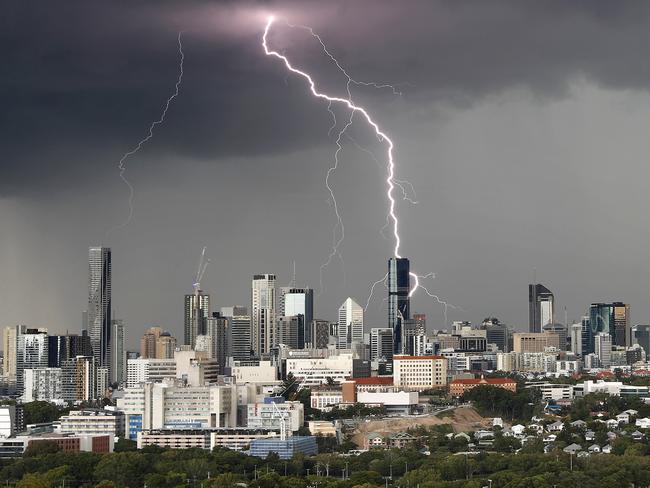
On the Gold Coast there were reports of continual thunder and lightning for an extended period.
At 5.50pm the bureau warned severe thunderstorms were detected on the weather radar near Beenleigh and Cleveland. They were moving east and forecast to affect Peel Island, southern waters of Moreton Bay and Mud Island by 6.20pm and Point Lookout, Amity Point and southern Moreton Island by 6.50pm.
Damaging winds and heavy rainfall that may lead to flash flooding were likely.


Michaela Motum said she was driving along the Mount Lindesay Highway at Jimboomba south of Brisbane when a large tree fell across the road.
“Just a warning, as I was heading along the highway, just coming up to the lights at Millstream Road, a large tree fell down in front of me and has blocked the highway,” she posted to Facebook.
“I ended up turning around and went a different way, but just letting anyone know who may be coming along that part of the highway. Stay safe everyone.”
Ms Motum said the tree landed between 15m-20m in front of her car, but she saw it starting to fall so was able to slow down before it fell.
A Queensland Police Service spokeswoman said the tree fell about 4.40pm and emergency services crews were now on the scene with chainsaws.
A minor flood warning was in place for the Brisbane River, Bremer River, and Warrill Creek.
A flood warning is in place for the Lockyer and Laidley Creeks, with the BOM issuing a flood watch for catchment areas across Queensland.
“Renewed rises are likely with thunderstorms especially in the smaller creeks and tributaries as catchments remain saturated,” the BOM posted on its Twitter feed on Sunday afternoon.
“Flash flooding is also a risk, so if it’s flooded, forget it.”
Despite river levels gradually easing following the recent flood event, the catchments are saturated and will likely respond quickly to expected rainfall late Sunday.
Earlier, Police Commissioner Katarina Carroll urged residents to be cautious on the roads once the predicted severe thunderstorms hit South East Queensland.

“It is still quite saturated and we will expect flash flooding,” she said.
“Please be patient, please keep off flooded waters.”
She said the latest flood death, Gold Coast woman Gabrielle Sale, was believed to be in her vehicle when it was swept away by floodwaters.
She was found tragically found a week later once waters had finally receded. She was the 11th person to die in the extreme weather event
“All of these deaths are a result of going into flooded waters – some definitely unintentional but some definitely making really, really poor decisions,” Ms Carroll said.
Atmospheric Scientist Brooke Pagel said isolated, dangerous thunderstorms with locally-destructive winds, giant hail and intense rainfall cannot be discounted in parts of South East Queensland.
“Because of the conditions at the moment with all this heat, there is the potential for those very dangerous thunderstorms,” Ms Pagel said.
Today, Ms Pagel said the area where the thunderstorms are concentrating is towards Wide Bay and across the South East Queensland coastline.
“At the moment, we’re looking at around the Gladstone area, potentially even Rockhampton all the way down to Dalby and Toowoomba and then down to Stanthorpe and then back to the Gold Coast,” Ms Pagel said.
“So … all South East Queensland, most of the Wide Bay Burnett and then parts of the Capricornia as well and then your Darling Downs and Granite Belt including Toowoomba.”
The Bureau of Meteorology has issued a hazardous surf warning for areas stretching from the Fraser Coast south to the Gold Coast, with deceptively powerful surf and swell conditions expected.
The Bureau of Meteorology advises people to stay out of the water and avoid walking near surf-exposed areas.
Updated forecasting at 10am extended the high-impact area to include areas between Gladstone and Biloela.
â›ˆï¸ UPDATED Sunday Thunderstorm Forecast: Severe storms likely for #SEQLD. Includes #Bundaberg #Gympie #LockyerValley #Brisbane #GoldCoast. Damaging winds, large hail, heavy rainfall, dangerous flash flooding. Very dangerous storms also a threat âš ï¸https://t.co/23ZyuisvIg @QldFES pic.twitter.com/tYCNtOg3Kq
— Bureau of Meteorology, Queensland (@BOM_Qld) March 6, 2022
Ms Pagel said today will be the main day of severe weather with Monday forecasted for potential severe thunderstorms and some reprieve further into the week.
“Going into Tuesday, we’ve got sunny conditions with a slight chance of a shower in the afternoon and in the evening,” Ms Pagel said.
It comes after Queensland’s Mud Army 2.0 was called off after just one day.
Brisbane City Council sent an email to the Mud Army 2.0’s 15 000 registered volunteers late on Saturday stating they could down tools.
“Due to (Saturday’s) incredible effort, Brisbane City Council has confirmed that the Mud Army 2.0 can now put down their tools and volunteers are no longer needed to clean-up Brisbane on Sunday,” the email stated.


Ice ice baby: Spectacular images of unseasonal frost as Qld freezes
Queensland’s overnight temperatures will increase to double digits in the coming days, following the coldest start to winter in 16 years, bringing frost and ice to many regions. SEE THE PHOTOS
Read more

City’s coldest June start in 16 years, feels like MINUS 9.8C out west
Southeast Queensland is shivering through its coldest morning in more than 15 years but feels-like temperatures have dropped to insane levels in the southern inland.
Read more