
How you can beat Sydney’s worst blackspot chaos
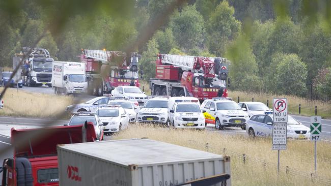
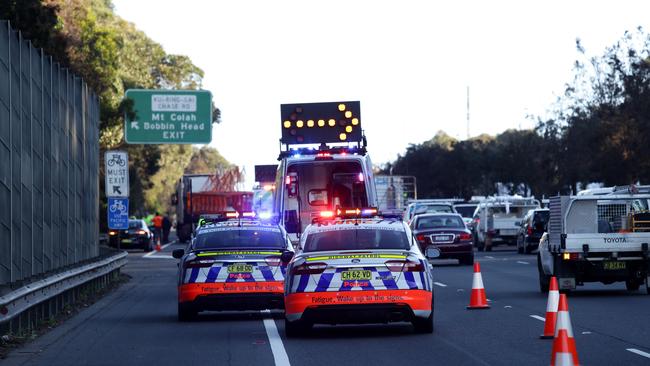
When a crash, breakdown, fuel spill or bingle happens on our roads network, Sydney is thrown into chaos. Today, The Daily Telegraph reveals the worst ‘pressure points’ on the city’s roads.
NSW
Don't miss out on the headlines from NSW. Followed categories will be added to My News.
When a crash, breakdown, fuel spill or even just a prang happens on Sydney roads, the network is thrown into chaos.
The fragility of Sydney’s spider web of arterials, intersections, motorways, roads and laneways is highlighted in the extreme during any type of incident.
With the help of a veteran traffic reporter, the NRMA and the Transport Management Centre, The Daily Telegraph has pinpointed the main ‘pressure points’ on Sydney’s road network and which surrounding roads feel the flow-on effects during incidents in these areas.
Ian Wallace sits in a small room at the Transport Management Centre for six hours a day observing hundreds of live traffic camera on five television screens.
He has been doing this for 36 years after taking a job as a reporter with the Australian Traffic Network in 1982.
Wallace knows Sydney like the back of his hand and has seen thousands of times what happens to the city and its surrounding suburbs after minor and major incidents.
“The flow-on effects of an incident on one side of Sydney affects the whole city,” Wallace said.
He compiled a list of the weakest points on the network and which roads experience the most congestion after an accident.
THE M5
The M5 is a hot spot for congestion, and Wallace believes anywhere between Prestons and Mascot is vulnerable.
He describes Fairford Road at Padstow to Mascot as the “bad part” for eastbound motorists in the morning with drivers becoming stuck in traffic right back to the Hume Motorway in Campbelltown if there is an incident.
During the afternoon peak, Mascot through to King Georges Road becomes the weak point with drivers travelling from the city and onto the M5 affected.
THE M4
The next danger spot on the network is the M4 between Roper Road at Colyton and Parramatta Road at Granville.
The flow-on effects for incidents at these spots are felt on several feeder roads coming onto the motorway: Roper Road at Colyton, Reservoir Road at Huntingwood, the Prospect Highway at Prospect and the Cumberland Highway at South Wentworthville all suffer.
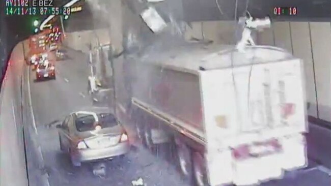
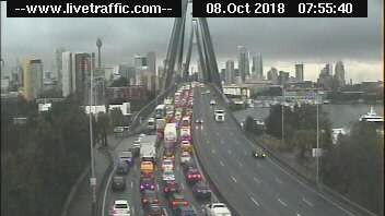
HARBOUR BRIDGE AND HARBOUR TUNNEL
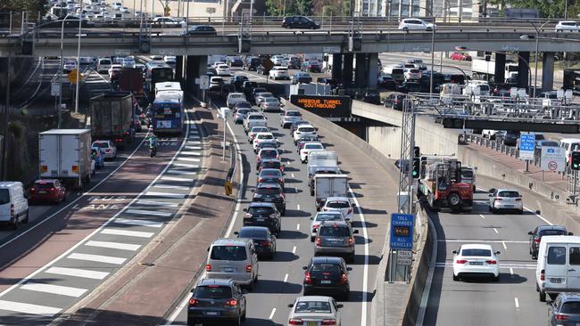
The Harbour Bridge and Harbour Tunnel can hardly be avoided for northern residents who work in the city but Wallace observes that the area is “getting better” since toll booths were removed.
Despite this, commuters can’t escape the occasional overheight truck becoming stuck in the tunnel or major accidents on the bridge causing severe ramifications.
Congestion can quickly stretch kilometres back to the M2 after the Lane Cove Tunnel, the Pacific Highway at Chatswood, Military Road, the Spit Road and Manly Road at Seaforth.
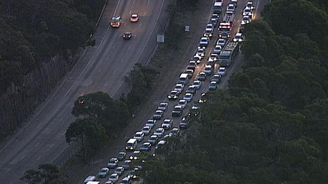
PENNANT HILLS ROAD
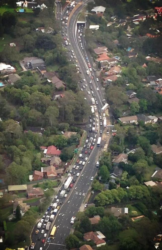
Pennant Hills Road is hardly Sydney’s biggest road but it often causes the most trouble.
It is currently the link between the M2 and M1 up to the Central Coast and a thoroughfare for large trucks. When these vehicles break down on Pennant Hills Road, traffic backs up onto both motorways.
Soon, thousands of trucks will have the option of avoiding Pennant Hills Road when the nine kilometre NorthConnex tunnel links the M1 at Wahroonga to the M2 at West Pennant Hills.
Construction on the tunnel is due to finish in 2020.
THE M7
The M7 is one of Sydney’s longest roads and provides a link to the M2, M4 and M5, but when accidents occur these four motorways feel the effects.
Wallace identifies the main pressure points from Richmond Road at Dean Park in the northwest to Cecil Hills in the west.
If anything happens on this stretch of the M7, chaos erupts with congestion quickly occurring from the M5 at Prestons right through to the M2 at Baulkham Hills.
VICTORIA ROAD
Victoria Road is a vulnerable arterial with pressure points from Gladesville Bridge all the way over the ANZAC Bridge and into the city.
Sydney traffic was brought to a standstill last month after a motorbike rider was killed in a crash on the ANZAC Bridge with motorists experiencing delays of up to 40 minutes.
THE M1
The M1 between Sydney and the Central Coast can become a nightmare during accidents with the Pacific Highway at Wahroonga and Pennant Hills Road both affected.
Roads leading onto the M1 from the Central Coast easily pile up with southbound drivers.
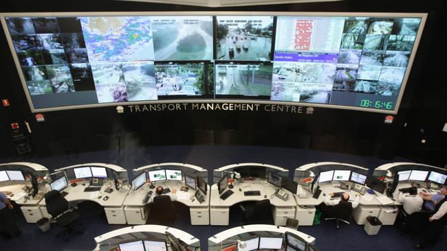
The Transport Management Centre, which manages thousands of incidents every month across NSW, identified a similar list to Wallace, providing the following locations as most prone to congestion resulting from incidents:
● Sydney Harbour Bridge, Harbour Tunnel and Anzac Bridge
● M5E and M5 corridor
● Eastern Distributor and Southern Cross Drive
● General Holmes Drive including the Airport tunnel
● M4 Motorway corridor
● M7 Motorway corridor
● Pennant Hills Road (particularly between the M1 and M2)
● M1 Pacific Motorway (particularly between Wahroonga and the central Coast).
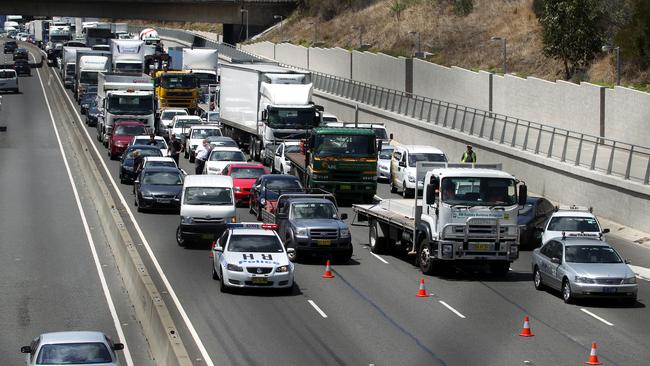
NRMA spokesman Peter Khoury said the current network is “fragile” and it doesn’t matter how small or large incidents are, the fragility of Sydney roads is felt across the city.
“Any time there is a break down on Pennant Hills Road … recently a truck broke down and getting in and out of Sydney became diabolic … that wasn’t a major incident,” Khoury said.
“A change in weather conditions can cause major congestion, a break down can throw Sydney into chaos.
“It’s fragile because we didn’t keep up with the growth of the city”.
“The reality is that when a major incident happens in a tunnel, the rest of Sydney is affected,” he said.

Despite the current situation, Khoury firmly believes things will get better for drivers when planned projects are finished across the city.
“Until the network is completed and public transport upgraded, congestion concerns will always be highlighted”.
“WestConnex and NorthConnex will make a huge impact”.
The NSW Government began addressing problem areas in 2007 with the first of three ‘Pinch Point’ programs operated by the Roads and Maritime Services.
Works undertaken by the RMS in this time have included extending and adding more right-turn bays, installing electronic message signs and CCTV cameras and widening sections of road.
In a statement the RMS said 185 projects have been completed and another 36 are planned.
“Motorists travelling through the intersection of Pennant Hills Road and The Crescent are now saving around 4.5 hours per year after the existing northbound right turn was extended,” the statement said.
Have we missed any spots? Have your say in the comments
Flood warnings remain as parts of NSW hit by heavy rainfall
Emergency crews have responded to hundreds of calls for help across NSW after a deep low pressure system unleashed torrential rain, thunderstorms and gusty winds over the weekend, with more showers expected in coming days.

Why this Sydney suburb has become our baby capital
One Sydney suburb is doing the heavy lifting when it comes to raising the next generation of Sydneysiders, with more babies born there than anywhere else in the Harbour City. Use our interactive map to see how your area ranks.