
We reveal the top five in our list of hidden tourism gems from across Tasmania — those special places often overlooked on the well-beaten tourist trails.
We complete our look at the best of these magical spots from around the state.
PART I: TASSIE’S HIDDEN TOURISM GEMS 25-21
PART II: TASSIE’S HIDDEN TOURISM GEMS 20-16
PART III: TASSIE’S HIDDEN TOURISM GEMS 15-11
PART IV: TASSIE’S HIDDEN TOURISM GEMS 10-6
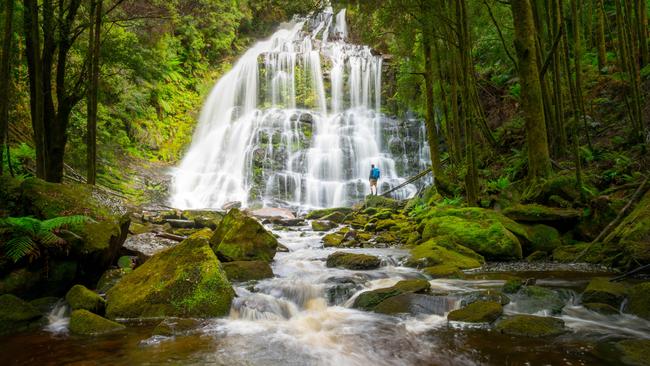
5NELSON RIVER FALLS
The long and winding trip to Queenstown on the Lyell Highway can be a killer — especially with young kids in the car. This 20-minute return walk, located about midway between Derwent Bridge and the West Coast mining town is well worth the stop to stretch the legs, breathe in the fresh air and shake your sillies out. Beautiful ferns line the flat easy track and a platform at the base of the falls makes for an enchanting interlude into the wilderness. The track is within the Franklin-Gordon Wild Rivers National Park and the falls are often overflowing with a spectacular display. Nelson Falls map
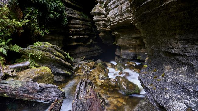
4 GROWLING SWALLET
You want to visit this place simply based on the name. It evokes some primordial monster hiding in the Tasmanian wilds … and it kind of is. A few kilometres inside the Florentine Valley and accessible via a locked gate (the key can be booked from the Mt Field National Park office with a $300 deposit) is one of the great rainforest walks. Allow about 90min return to the highlight of the walk — the Growling Swallet. It’s actually an entrance to the Junee limestone cave system where the Junee river is “swallowed up” and disappears into the ground. The track can be quite wet so boots and gaiters are advisable. Growling Swallet map

3 ALUM CLIFFS LOOKOUT
Not to be confused with the popular walks linking the Hobart suburbs of Kingston and Taroona, the Tulampanga/Alum Cliffs Lookout, is a little-known attraction about 4km from Chudleigh. Turn off the Mole Creek Rd and follow the signs through farmland to a carpark at the base of a hill. The 45-minute return walk climbs gently to the top of a hill where the track descends slightly into bushland which winds out along a ridge. The track ends suddenly with a viewing platform high above the Mersey River. It is a stunning outlook over a deep gorge with towering ancient rock formations across the gorge and deep rainforest 200m below. The gorge is in the Alum Cliffs State Reserve and is part of the Tolkienesque Gog Range at the back of Mt Roland. If you’re lucky you may even spot an eagle or two which are common in the area. Alum Cliffs Lookout map
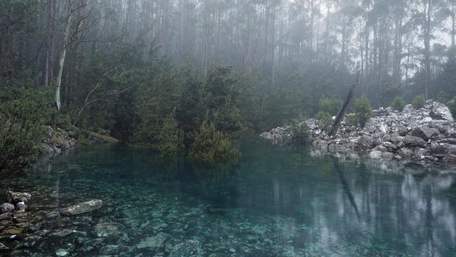
2 DISAPPEARING TARN
There’s an air of mystique about this rare and elusive gem on kunanyi/Mt Wellington. It only appears a handful of times in a year and only after heavy rainfall or snowfall. The quickest way to get there is via Milles Track and Wellington Falls tracks. The four-hour 6.5km return walk starts at the Springs carpark, midway up the mountain. The tarn, or small lake, fills with astonishingly clear, blue-green water where you can clearly see the grey dolerite boulders underneath the surface. The magical tarn fills and drains within hours, hence its name. Disappearing Tarn map
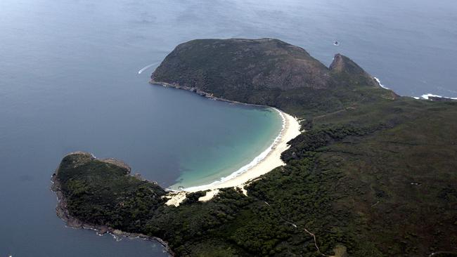
1 CRESCENT BAY
If Crescent Bay was located anywhere else is the world there would probably be hotels nearby, duckboarded paths and lots of tourists with selfie sticks. This is a drop-dead gorgeous beach just a few kilometres from one of the state’s leading tourist attractions in the Port Arthur Historic site. The beach is an easy two-hour return walk from a track which starts about 50m before the Remarkable Cave carpark. The walk leads along the coastline towards Mt Brown, a hour-return detour for those looking for spectacular views of Cape Pillar and Tasman Island. The beach is surrounded by 50m dunes — great for sliding down — and opens onto views of Cape Pillar and Tasman Island. It is considered one of the most picturesque beaches on the Tasman Peninsula, if not Tasmania. A word of warning: Snakes are numerous in the area during the warmer months. Crescent Bay map
Add your comment to this story
To join the conversation, please log in. Don't have an account? Register
Join the conversation, you are commenting as Logout
Check out Airbnb’s latest: Where history meets slow travel bliss
Overlooking Australia’s oldest bridge in the historic village of Richmond, this convict-crafted accommodation offers a backstage pass to history – best enjoyed with a glass of wine in hand, writes Cas Garvey
Is this Bicheno’s dreamiest coastal outlook?
Perched on a sand dune overlooking the ocean, this East Coast retreat offers dazzling views, style and serenity. Add sun, wild swims and whale sightings – it’s clear Bicheno has never looked better