
OUR island is home to a multitude of little gems – attractions well-known to the locals but not always included on tourist maps.
Here's our countdown of some of the state’s lesser-known treasures which are easily accessible and rival some of Tasmania’s more iconic tourist attractions.

25 MICKEYS BEACH
About an hour’s drive from Hobart via Huonville and Cygnet, Mickeys is a gorgeous, sheltered bush beach popular with locals, families, snorkellers and divers. Head to Randalls Bay, where there’s a barbecue and toilets, and continue to Eggs and Bacon Bay. Look for a sign on the left, which marks the entrance to a bumpy dirt road that leads to a car park above the beach. It’s a short walk from there down a narrow and fairly steep stairwell to a protected, sandy beach with rock platforms at either end. There’s a 30-minute return bushwalk around the headland to Randalls Bay. Mickeys Beach map

24 COAL POINT
Snorkel at Coal Point near Adventure Bay on Bruny Island. In a blink-and-you’ll miss it spot off Adventure Bay Rd (about halfway between The Neck beach and Adventure Bay), Coal Point is popular with snorkellers and divers. The water is crystal clear, there are rock platforms populated by sea birds, and the view across Adventure Bay to the spectacular Fluted Cape is beautiful. Bring a picnic, sunhat (there’s not much shade) and your snorkelling gear, or buy basic equipment and other supplies at nearby Adventure Bay General Store (712 Adventure Bay Rd, Adventure Bay, 6293 1119). A word of warning: Divers report having seen sharks in the area. Coal Bay map

23 EDGE OF THE WORLD
Located at Gardiner Point on the Arthur River, as far west in Tasmania as you can get, sits one of the area’s best-kept secrets, a spot locally known as the Edge of the World.
The spot, which is also included in the pristine Tarkine wilderness area, sits on a rugged storm-swept coastline, regularly lashed by the winds of the Roaring Forties at a point where a combination of ocean currents and river flow createsa churning effect at the river’s mouth that deposits ancient logs on the beach.
The spot also looks out on what is arguably the longest uninterrupted expanse of ocean on the globe.
Once you get out there and get buffeted by those winds and the clean pure air it really is quite possible to let all your cares drift away and it feels as though you really are standing on the edge of the world.
Arthur River is a two-hour drive (150km) from Burnie, in the state’s North-West. To get there take the Bass Highway from Stanley or Smithton and then the Arthur River Rd. Edge of the World map
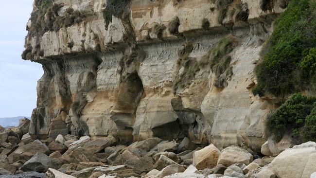
22 FOSSIL BLUFF
Ancient sandstone cliffs at the end of a beach is a treasure trove of fossils which make this spot standout on Tasmania’s North-West Coast at Wynyard. Caves can be explored at low tide and the 30m cliff of 275 million-year-old sandstone carries several hundred different types of fossils. In fact it claims to be the location of Australia’s oldest fossil marsupial — a 25 million-year-old specimen found in the mid 19th century. A short, sharp climb to a lookout is rewarded with a fantastic view of Bass Strait. Fossil Bluff map

21 DONAGHYS HILL LOOKOUT
For anyone who has driven the Lyell Highway to Tasmania’s West Coast, it's easy to bypass this signpost about midway between Derwent Bridge and Queenstown near the Franklin River. It’s a very pleasant way to break up the journey and on a clear day you will be rewarded with amazing views to the both north and south. The walk is a 1.1km easy hike (40 minutes return) along the Donaghys Hill Nature Trail which ends with a lookout on a ridge straddling two valleys. To the south west Frenchmans Cap dominates the skyline and to the north is Mt Rufus and the Collingwood River. Donaghys Hill Lookout map
Add your comment to this story
To join the conversation, please log in. Don't have an account? Register
Join the conversation, you are commenting as Logout
Check out Airbnb’s latest: Where history meets slow travel bliss
Overlooking Australia’s oldest bridge in the historic village of Richmond, this convict-crafted accommodation offers a backstage pass to history – best enjoyed with a glass of wine in hand, writes Cas Garvey
Is this Bicheno’s dreamiest coastal outlook?
Perched on a sand dune overlooking the ocean, this East Coast retreat offers dazzling views, style and serenity. Add sun, wild swims and whale sightings – it’s clear Bicheno has never looked better