
OUR island is home to a multitude of little natural gems – attractions well-known to the locals but not always included on tourist maps.
Today we continue our look at the best of these special spots which are easily accessible and rival some of Tasmania’s more iconic tourist attractions.
PART I: TASSIE’S HIDDEN TOURISM GEMS 25-21

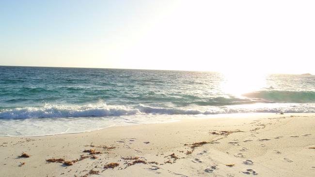
20 SURVEYORS BAY
This gorgeous sandy beach is one of several rewards on a spectacular stretch of road between Surges Bay and Dover. Take the scenic Esperance Coast Rd and you’ll discover a wondrous part of southern Tasmania. The road mostly hugs the shoreline, offering views of the Huon River and Huon Point, the entrance to the estuary. Heading south, Surveyors is the first of several beaches including Roaring Bay Beach and Little Roaring Bay Beach, which are also popular with locals. Surveyors Bay, at the foot of a hill, has crystal clear water and the beach is backed by pretty holiday cottages. Surveyors Bay map
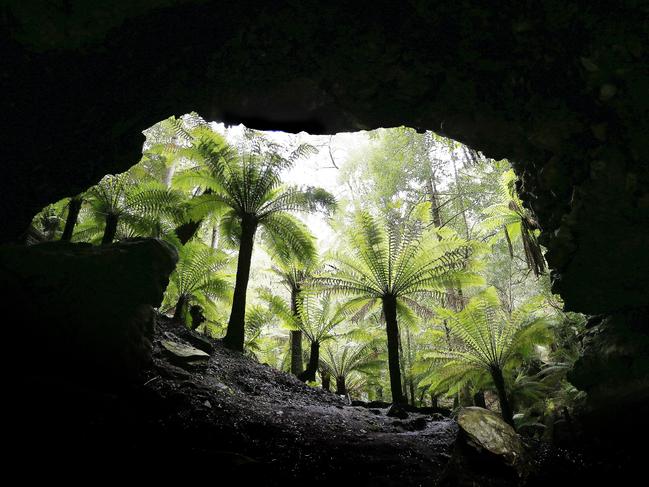
1 9 TROWUTTA ARCH
This rare geological feature is an easy 15-minute walk through rainforest at the Trowutta Caves State Reserve, located 50min south of Stanley in the state’s North-West. Described by some as walking into another world, the stroll along an all-weather path through lush green rainforest with towering gums and impressive man ferns, ends at the Trowutta Arch — a cave-like arch leading to a jagged wall of limestone with a pool of water at its base. Trowutta Arch map
18 STUMPYS BAY
Everyone knows the name Bay of Fires but few are familiar with Stumpys Bay — and it’s not really to do with the daggy name. Stumpys Bay is on the eastern coastline of Mt William National Park in the state’s North-East and not many people visit as it is a little out of the way and involves travelling on gravel roads. If you have seen any postcard images of the Bay of Fires, it’s most likely they are from here — think blinding white beaches, bright-orange lichen-covered boulders and water so blue it makes your eyes water. There are four camp grounds dotted along the coast where you can fall to sleep to the sound of waves – campfires are allowed at different times of the year. There are easy one- to two-hour return walks to Mt William and Cobbler Rocks, there’s a boat ramp and some of the best snorkelling and scuba diving in the state. Stumpys Bay map

17 DEVILS GULLET
Don’t be put off by the name. If you’re ever in the Mole Creek caves area, a detour to this lookout is well worth the time.
It’s about a 35-minute drive from Mole Creek past Marakoopa and King Solomons Caves, then up the Mersey Forest Rd for a very short distance, turning left at the signposted road to Devils Gullet and Lake Mackenzie. The 14km gravel road winds its way up on to the Western Tiers and the easy 15-minute walk from a small cark park is rewarded with a breathtaking lookout on the edge of 220m cliffs overlooking a deep glacial gorge. On a clear day the views south take in the Walls of Jerusalem National Park, Mt Ossa and Frenchmans Cap. Devils Gullet map
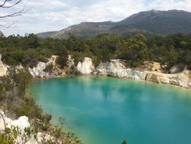
16 LITTLE BLUE LAKE
Little Blue Lake delivers exactly what it promises. About an hour and a half from Launceston, past Derby, the lake is a vivid turquoise thanks to high mineral content in the water from the old mines of Mt Cameron. Little Blue Lake is highly instagrammable and stunning on a clear day. But be warned: it is not safe for swimming. Pack a picnic and take your new profile pic instead. When you’re done, double back to Derby for lunch or try the Scottsdale Bakery. Well worth the trip.
PART III: TASSIE'S HIDDEN GEMS 15-11
Add your comment to this story
To join the conversation, please log in. Don't have an account? Register
Join the conversation, you are commenting as Logout
Check out Airbnb’s latest: Where history meets slow travel bliss
Overlooking Australia’s oldest bridge in the historic village of Richmond, this convict-crafted accommodation offers a backstage pass to history – best enjoyed with a glass of wine in hand, writes Cas Garvey
Is this Bicheno’s dreamiest coastal outlook?
Perched on a sand dune overlooking the ocean, this East Coast retreat offers dazzling views, style and serenity. Add sun, wild swims and whale sightings – it’s clear Bicheno has never looked better