

OUR island is home to a multitude of little natural gems — attractions well-known to the locals but not always included on tourist maps.
Today we continue our look at the best of these special spots which are easily accessible and rival some of Tasmania’s more iconic tourist attractions.
PART I: TASSIE’S HIDDEN TOURISM GEMS 25-21
PART II: TASSIE’S HIDDEN TOURISM GEMS 20-16
15 BIRD RIVER TRACK
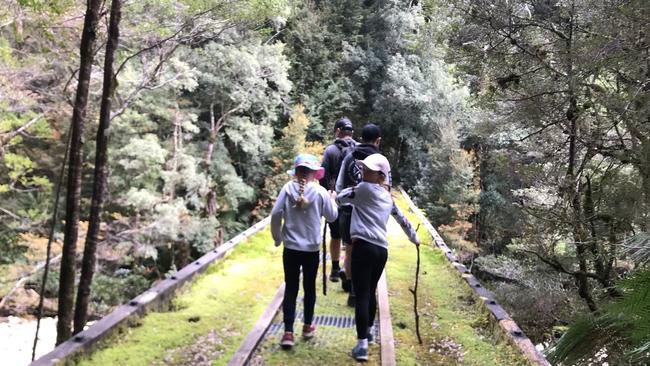
A ghost town that still speaks of its mining boom past lies 40km south of Queenstown via Mt Jukes Rd (11km gravel). East Pillinger was a busy town at Kelly Basin on the shores of Macquarie Harbour in the late 1800s to early 1900s before it was replaced by Strahan as the main port centre. Most of East Pillinger has been swallowed by rainforest but intriguing and surprisingly intact ruins remain. The return walk from the Bird River Bridge takes three to four hours, following the old railway track, and is lined by spectacular rainforest — and the tannin-stained water of the Bird River for much of the journey. The track has some landslides and washouts but is not difficult and ideal for families. The walk can also be accessed by boat via Macquarie Harbour. There is a toilet at East Pillinger and the small jetty is a perfect place to have lunch. But you may need gumboots if attempted in winter! Bird River Track map
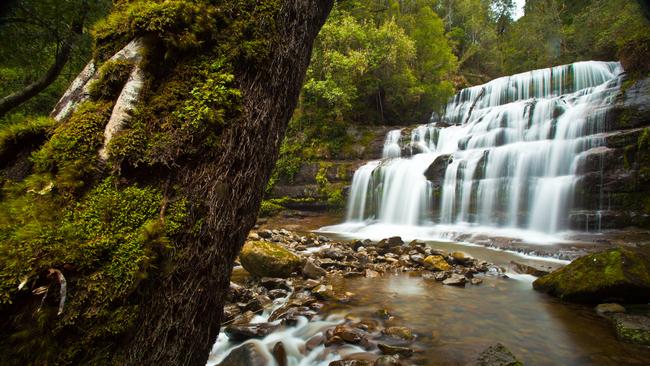
14 LIFFEY FALLS
Many claim this waterfall is Tasmania’s most beautiful and it’s easy to see why. The picturesque Liffey Falls is within a cool temperate rainforest reserve, surrounded by myrtle, sassafras and leatherwood trees. Liffey Falls is a series of four cascades on the Liffey River, culminating in the picturesque waterfall.
The shortest walk to the falls is via the 1km track from the top car park and takes about 45 minutes return. The falls can also be reached from the lower car park on a longer, lower grade track. The Liffey Falls State Reserve lies on the Western Tiers and is a 35-minute drive from Mole Creek. Liffey Falls map
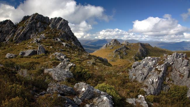
13 THE NEEDLES
A jagged ridge line known as The Needles on the northern edge of the Southwest National Park comes into view while travelling along the Gordon River Rd 16.5km past Maydena, beyond Mt Field. The trail starts opposite a small car park signposted on the highest point of the road (651m) and the two-hour return walk is considered one of the most rewarding in Southern Tasmania. In the right conditions, the climb to the summit (1020m) offers uninterrupted views of Mt Anne to the south and Mt Field West to the north as well as glimpses of Lake Pedder and Lake Gordon to the west. The Needles map

12 LOST WORLD
More than 300,000 visitors make it to the top of Mt Wellington/kunanyi each year and most would drive straight past a track near the top to a hidden gem on the mountain. The Lost World is a short walk (40 minutes return) to a set of dolerite cliffs, smaller than the Organ Pipes. The track involves some minor rock scrambling and twists down through snow gums and large boulders to the foot of the cliffs for stunning views of the city and many interesting rock formations. If it’s blowing a gale on top of the mountain, the Lost World often offers a sheltered haven protected from the elements. Footnote: The Lost World track has been closed since the May floods but repair work is scheduled in the new year. Lost World map

11 HARTZ PEAK
The best part about a visit to Hartz Peak is that most of the climbing is done in your car — a 34km drive from Geeveston, the last 21km on gravel.
The walk starts at an elevation of about 800m and the four-five hour return hike starts through low bush before a moderate climb up to Lake Esperance, about 40 minutes in. The lake itself is a charming stop and if the weather is unfavourable or your fitness isn’t up to it, can be a spectacular destination in itself.
Duck boarding protects the delicate alpine flora as the walk continues up towards the 1254m peak, which steps up to a saddle before tricky rock hopping to the summit. The geology is the same dolerite formations as Mt Field and Mt Wellington with impressive boulders and sheer cliffs.
On a good day the peak offers amazing views across to the southwest and east and north to Bruny Island and the Huon Valley. But be warned: this is alpine wilderness and the weather can turn extreme very quickly — check the forecast before setting out and be prepared. Hartz Peak map
Add your comment to this story
To join the conversation, please log in. Don't have an account? Register
Join the conversation, you are commenting as Logout
Check out Airbnb’s latest: Where history meets slow travel bliss
Overlooking Australia’s oldest bridge in the historic village of Richmond, this convict-crafted accommodation offers a backstage pass to history – best enjoyed with a glass of wine in hand, writes Cas Garvey
Is this Bicheno’s dreamiest coastal outlook?
Perched on a sand dune overlooking the ocean, this East Coast retreat offers dazzling views, style and serenity. Add sun, wild swims and whale sightings – it’s clear Bicheno has never looked better