
Some of Tassie’s hidden tourism treasures are not that easy to get to. We go off the beaten track to find a few more in our series of hidden gems.
We continue our look at the best of these special spots from around the state.
PART I: TASSIE’S HIDDEN TOURISM GEMS 25-21
PART II: TASSIE’S HIDDEN TOURISM GEMS 20-16
PART III: TASSIE’S HIDDEN TOURISM GEMS 15-11
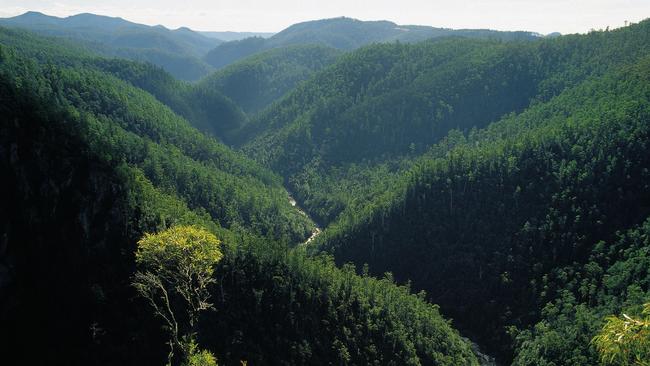
10 LEVEN CANYON
IN the shadow of Black Bluff in the hinterland behind Ulverstone is a canyon which takes the breath away on first viewing.
Parks and Wildlife says it is rare in the world to find such a powerful place as the Leven Canyon, that is so easy to access.
An easy 10-minute walk takes you from the car park and barbecue area to the lookout where 250m below you see the Leven River snaking its way down towards the coast.
The more adventurous can take the Leven Canyon 1.8km, grade 3 circuit — but be warned it is steep. Leven Canyon is 45-minute drive from Ulverstone or can be reached
from Cradle Mountain. Leven Canyon map

9 HENTY DUNES
They’re not exactly hidden — in fact these huge dunes which run for 15km north from Strahan on Tassie’s West Coast are difficult to miss. But these dunes formed over thousands of years by the Roaring Forties are often bypassed on the way to nearby attractions. Drive north towards Zeehan and pull in to any number of side roads and you’ll come to a 30m wall of sand. There is a designated picnic area about 14km up the road. Of course the dunes are great fun for kids and adults and you can spend hours sliding down them. A climb to the top reveals amazing moonscape vistas stretching for kilometres in every direction. A kilometre or so walk takes you to the sea and Ocean Beach — Tasmania’s longest. There is an abundance of birdlife and during the summer, and mutton birds can be seen at dusk returning to their burrows. Map of Henty Dunes
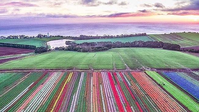
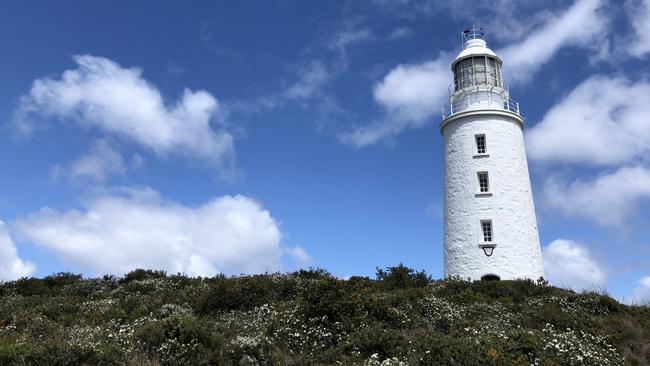
8 TABLE CAPE
The magnificent plateau of Table Cape is Wynyard’s most remarkable natural attraction and home to the only operating lighthouse in Tasmania open to public tours.
Table Cape is a 180m high volcanic plug which provides spectacular views of the coast and patchwork quilt agricultural farmlands.
As you drive to the top of the remains of a 12-million-year-old volcano you’ll reach a viewing platform where, on a clear day, you can see George Town’s Low Head and mountain ranges more than 175km away.
Table Cape is also home to the Table Cape Tulip Farm where acres of fields explode with colour each spring.
The Bloomin’ Tulips Festival, which is held in Wynyard every October, was recently named as Tasmania’s Best Regional Event at the 2018 Australian Events Awards and Symposium.
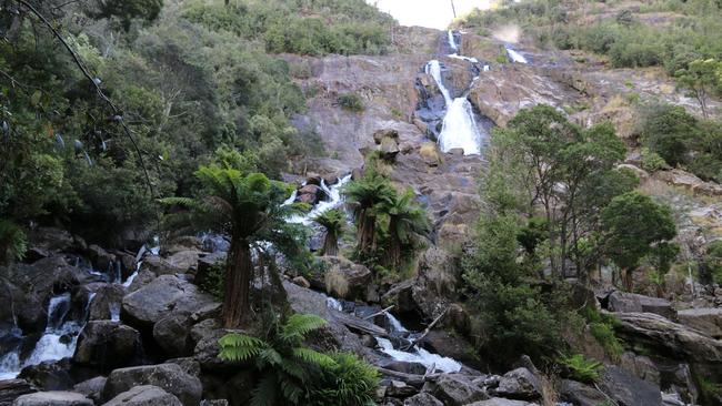
7 ST COLUMBA FALLS
St Columba Falls, at Pyengana in the state’s North-East, is one of Tasmania’s highest multi-tiered waterfalls. A high-quality walking track leads from the car park through cool and shady rainforest down to a viewing platform at the base of the stunning falls where the South George River plunges over steep granite ledges. There is a moderate uphill walk for the return trip but for those unable or unwilling to take the walk, the falls can be viewed from the car park. To get here, take the A3 north from St Helens or east from Scottsdale and turn onto the C428 at Pyengana. There is a sealed road all the way.
For the more adventurous, nearby Ralphs Falls can be reached via a rough drive over a gravel forestry road. At over 90 metres, Ralphs Falls is Tasmania’s highest single-drop waterfall, a thin ribbon of water plunging down a near-vertical rock face. The easy walk from the car park along a well-maintained track ends on a platform offering stunning views of the falls and out across Cash’s Gorge.
Both falls have picnic and toilet facilities.
This region of the state was once well populated with Tasmanian tigers, so keep your eyes peeled. You just never know what might be lurking in the undergrowth.
6 CAPE BRUNY LIGHTHOUSE
As lighthouses go the 13m Cape Bruny tower stands tall as a remarkable feat in engineering – especially when you consider it was built by convict labour from locally quarried dolerite in less than two years. If was built today, it would likely take a decade. It was first lit in 1838 and was the longest continually staffed extant lighthouse when it was finally replaced by a nearby light in 1996. Aside from the history, the setting is straight from a storybook with towering cliffs of dolerite, pounding waves and, more often than not, a roaring wind. To get there drive south 30min from Lunawanna for about 20km to a carpark where it’s a short sharp walk up to the lighthouse. For a price you can take a tour and climb the tower, but the views are spectacular at ground level.
Add your comment to this story
To join the conversation, please log in. Don't have an account? Register
Join the conversation, you are commenting as Logout
Check out Airbnb’s latest: Where history meets slow travel bliss
Overlooking Australia’s oldest bridge in the historic village of Richmond, this convict-crafted accommodation offers a backstage pass to history – best enjoyed with a glass of wine in hand, writes Cas Garvey
Is this Bicheno’s dreamiest coastal outlook?
Perched on a sand dune overlooking the ocean, this East Coast retreat offers dazzling views, style and serenity. Add sun, wild swims and whale sightings – it’s clear Bicheno has never looked better