
Qld weather: Residents warned CBD could flood again
Gympie residents are tonight preparing for the likelihood their CBD will once again be inundated by floodwaters, as flights are diverted, schools closed, and multiple major flood warnings issued across the state.

QLD weather news
Don't miss out on the headlines from QLD weather news. Followed categories will be added to My News.
A flooding emergency is unfolding across parts of the southeast after heavy rain has continued across large parts of Queensland overnight and through the day.
Hundreds of homes are facing inundation, towns are going under, flights are being diverted or delayed and 70 schools across the state were forced to close.
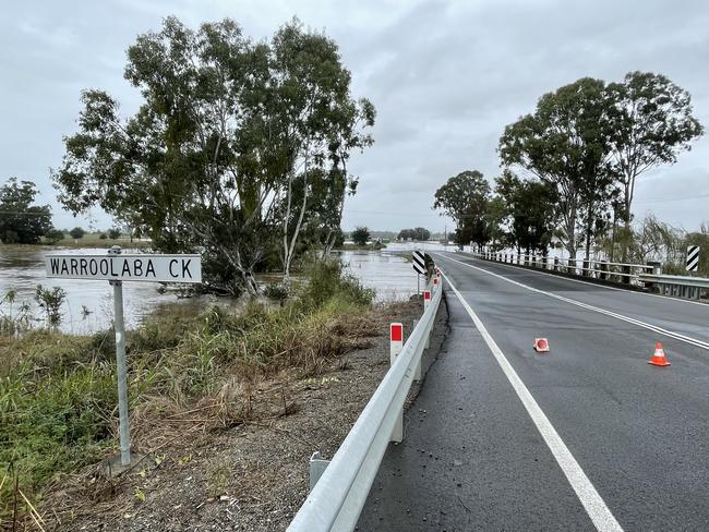
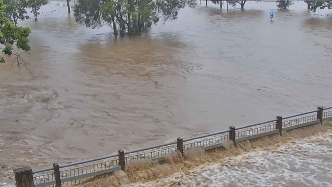
Gympie residents have tonight been told that floodwaters could enter the CBD on Saturday morning, as the Mary River continued to rise.
The Mary reached the moderate flooding level at 8.10pm on Friday night, recording a reading of 12.01m. By 10pm it was at 12.26m and rising. The Bureau said that the peak could be as high as 15m on Saturday morning.
Further north in Maryborough, the Mary River is expected to stay below the minor flood level of 5m throughout Saturday morning, although could surpass that moving into the evening.
Gympie is forecast to receive up to 50mm of rain on Saturday, while Maryborough could see up to 60mm.
Major flood alerts were earlier issued for the Logan River to Yarrahappini, as well as Warrill Creek and Bremer River, Laidley and Lockyer creeks, while a minor flood warning has been issued for the Lower Brisbane River.
The Logan River at Beaudesert was at 9.82 metres (above the level of the bridge 9.80m) and rising at 4.30pm, with major flooding already occurring, with the warning suggesting it mat peak near 10.30 metres later in the evening.
Meanwhile, experts warned Warwick residents and business owners to prepare for the Condamine River to peak at a flood height just below that recorded in the devastating 2011 flooding event.
The Bureau of Meteorology predicted the Condamine River at Warwick would peak at about 8.2m between 6pm and 8pm.
In Brisbane’s north, an “incredibly lucky” woman has escaped uninjured after her car rolled off a roadway and into a creek on Friday afternoon.
Emergency services were called to the Maundrell Terrace and Redbourne St intersection at 4.15pm, with initial investigations suggesting that the Ford Territory hit a guardrail before coming off the road and rolling into Downfall Creek below.
A spokeswoman for the Queensland Ambulance Service said the 25-year-old female driver had been able to get herself out of the vehicle before emergency services arrived.
“She’s a very lucky woman. She doesn’t have any injuries, it sounds like she was incredibly lucky,” the spokeswoman said.
Swiftwater rescue crews had been dispatched to the scene but were not required.
Maundrell Terrace was also closed southbound causing delays while the vehicle was recovered from the creek, but reopened at 5.15pm.
A local resident told The Courier Mail this was not the first time a car had ended up in the creek.
“A couple have been through here before,” she said.
“It’s crazy, just crazy – I don’t understand how that happens.”
This afternoon Fire and Rescue swiftwater technicians assisted evacuate residents from homes in Warwick who had been impacted by floodwater.
— Qld Fire & Emergency (@QldFES) May 13, 2022
With more heavy rain expected into the weekend, make sure you stay up to date with warnings from @BOM_Qld. pic.twitter.com/qRyQVscrn6
Earlier, nine school-aged children were evacuated from Pomona State School on the Sunshine Coast after they were cut off by rising floodwater.
A Queensland Fire and Emergency spokeswoman said four crews were called to Station St, Pomona, at 11.05am after reports the children and an adult had been left stranded on the other side.
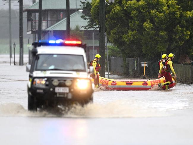
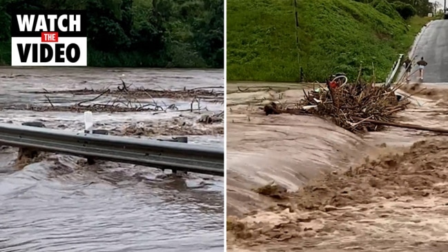
A number of people were also rescued by bystanders and emergency crews west of Brisbane, with three crews helping to retrieve a person from floodwaters at Laidley about 10am Friday after their vehicle was swept away.
Another incident was unfolding at Sairney View in the Somerset region.
To the city’s north, motorists have been urged to avoid the Bruce Highway if possible, with several flood closures expected as water levels rise.
The Department of Transport and Main Roads has warned the highway north and south of Gympie could close if the Mary River continued to rise.
It comes after the department closed a section of the highway north of Gin Gin earlier today.
“Please reconsider plans for travel through this area,” a DTMR post regarding Gympie read.
More than a dozen flights due to land in Brisbane this afternoon have been delayed or cancelled, according to Brisbane Airport’s website.
Both Bundaberg and Hervey Bay airports had a similar issue.
A Qantas spokeswoman confirmed some of the airline’s flights had been impacted and would continue to be if the weather continued to worsen.
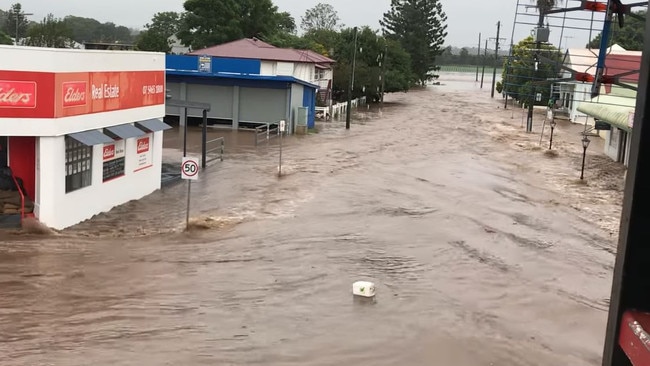
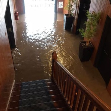
To the west, the main street of Laidley was awash with flood waters this morning, with nervous residents and business owners sweating on water levels.
Laidley real estate agent Darryl Muckert’s Patrick St business was under threat.
He said and his staff had managed to move computers and important items out of the office in case the worst happened.
He said the water had stopped short of going inside his shop – for now.
“The rain has stopped to a drizzle now,” Mr Muckert said about 10.50am.
“But it does make you really nervous.
“There’s so much water around and coming down. People have been rescued in the street, when it comes up it comes up quick.”
Mr Muckert said his office was inundated in both 2011 and 2013 events but was spared in February.
The SES has had more than 300 call-outs overnight, mostly for leaking roofs, but also to help people leave their homes.
Lockyer Valley Regional Council Mayor Cr Tanya Milligan on Friday evening said she was proud of her community for rallying together during the “soul destroying” floods.
“We’re already talking about having staff come in on the weekend to try and get cleaned up,” she said.
“The sooner you get in there and start cleaning up, the quicker we can recover. Debris and devastation is just soul destroying.”
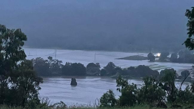
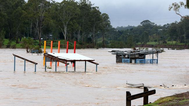
With an estimated 260 houses inundated with flood waters, 135 roads closed and 237 power outages Ms Milligan warned residents to remain aware of their surroundings.
“If people haven’t reached out to family and friends, let them know you’re OK, and just be really aware, with inundation, no one knows what’s under the water,” she said.
Despite some residents weathering two major flooding events in just three months, Ms Milligan said the community spirit was still strong in the Lockyer Valley.
“I take my hat off to my community for the way they’ve just rallied around each other. It continually amazes me, especially considering how much devastation there is,” she said.
Premier Annastacia Palaszczuk says the current weather event will continue beyond the next 24 hours and asked residents who live in areas of rising creeks and rivers to “be prepared”.
“This rainfall is not like what we saw in the previous event, this rainfall is a bit more sporadic,” she said.
“We are still seeing cases of rivers rising and flooding in particular areas.”
Ms Palaszczuk said 300 properties have been affected by floodwater so far, however the Brisbane River is not expected to rise about moderate flood level.
The Premier said Wivenhoe Dam had “plenty” of available storage.
“If you were impacted by creeks of catchment areas last time, you could be monitoring things closely and listening to your local councils,” she said.
“We are not expecting to see the higher amounts of Brisbane River rise, but depending on where the rain falls, that could impact different catchments.
“Storages across the SEQ grid have gone from 89 per cent to 97 per cent, Wivenhoe is at 110.5 per cent, in February it was 185 per cent, so there’s plenty of flood storage available.”

The Bureau has said the “evolving situation” means that rainfall would continue into tomorrow, with widespread areas of rainfall and risk of landslides.
“For the Brisbane River we are expecting to see minor flooding on the high tides,” meteorologist Laura Boekel said.
“We are expected to see similar peaks at high tides, tonight at 8pm and tomorrow morning.
The BOM echoed the Premier’s words, saying the current weather event was different to the February flood event, and will carry only a minor flood risk.
“We don’t need to see a lot of rainfall so see rises in the creeks, and when we do see intense pockets of rainfall we will see rises.”
Department of Regional Development, Infrastructure and Water Director-General Graham Fraine said SEQWater stood up its dam defences midweek, with the southeast water grid sitting at about 94 per cent.
⌠BEACHES CLOSED âŒ
— Surf Life Saving Queensland (SLSQ) (@lifesavingqld) May 13, 2022
The following beaches due to dangerous surf: #AlexHeadlands#Coolum#DickyBeach#MainBeach (Pt Lookout)#Marcoola#Maroochydore#Mooloolaba#Mudjimba#Peregian#RainbowBeach#TwinWaters#RiverwayLagoon
All #GoldCoast beaches are closed @cityofgoldcoastpic.twitter.com/OmMsOzJtZP
He said Somerset Dam was now sitting at 89 per cent and North Pine 79 per cent.
“Wivenhoe itself is currently at 110 per cent so it’s using a portion of its flood storage compartment but there is still over 88 per cent of its storage compartment available,” Mr Fraine said.
He said some of the state’s 20 ungated dams were spilling but operating as expected.
As many as 18 emergency alerts have been activated over the past 24 hours, with one issued by the Lockyer Valley Regional Council at 3.30am on Friday urging people to move to higher ground if it was safe to do so.
The latest was for Millmerran in the Toowoomba region, where the Condamine River is rising.
An earlier alert from the Somerset Regional Council says flooding along Lockyer Creek could reach 13 metres and that people whose homes flooded earlier this year should activate emergency plans.
SCROLL DOWN FOR THE FULL LIST OF SCHOOL CLOSURES
The Grantham Flood Warning siren has been reactivated for the second time to alert the inundated Lockyer Valley community with a renewed call for residents to move to higher ground immediately.
“Do not wait for further direction to relocate – this is an emergency alert,” the Lockyer Valley Regional Council posted to social media at 8.17am.
Residents were being told to relocate to higher ground and relocate to family and friends as a matter of urgency.
People can also seek shelter at the Grantham Butter Factory, Gatton Shire Hall and Helidon RSL.
The Grantham flood warning siren was installed after the deadly 2011 floods.
A shelter has been opened at the Lowood State High School Hall on Prospect St.
Lockyer Valley Mayor Tanya Milligan this morning confirmed that flood sirens had been sounded at Grantham and that police had doorknocked in the area.
She told the ABC that shelters were open and that swiftwater rescue teams were on standby, but had so far not been called out.
She said that it was possible about 260 homes could be inundated across the region.
“Most of the homes that we predict to be inundated by floodwaters are situated in the Forest Hill, Grantham, Laidley and Laidley CBD areas,” Ms Milligan said.

“We are still clearing our minds from the flooding event of February and March.”
By 1pm Laidley’s CBD was completely isolated, with deep flood water blocking all roads into the town.
Rain had significantly picked up in Laidley’s surrounding towns, with patchy yet heavy downpours across Rosewood and Grandchester.
The Queensland Police Service is now urging people in low-lying areas across the Lockyer Valley to self-evacuate.
The Lockyer Valley alert was one of a series of emergency alerts issued overnight – with residents in Warwick, Allora, Stanthorpe and parts of the Scenic Rim also warned of weather dangers.
Dozens of flood warnings also remain current across the state.
Scenic Rim Mayor Greg Christensen said it had been a challenging night across the region, and urged people to stay off the roads and work from home if possible.
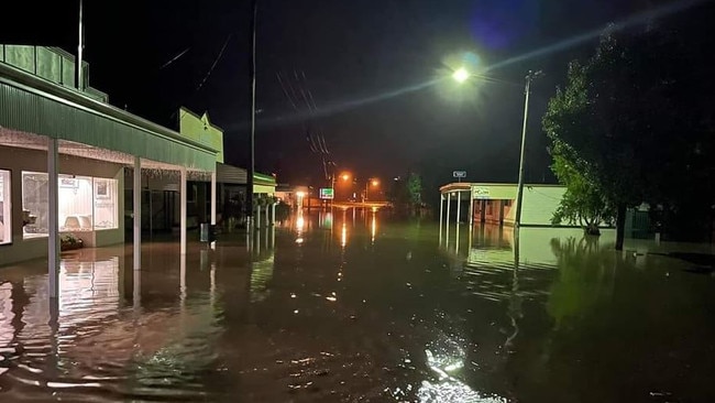
The main street of Killarney, in the Southern Downs region, was inundated by floodwaters on Thursday night, several hours after an initial flood warning was issued for the area.
Images posted to social media late on Thursday show floodwaters rising on what is believed to be Ivy St, inundating businesses and swamping roads.
The Condamine River was approaching the 6m major flood level late on Thursday night, recording a height of 5.80m and rising at 11pm.
A severe weather warning is now in place for areas from Capricornia to the southeast corner and inland.
An upper low that is creating the rain is expected to move south during Friday, with six-hour falls of up to 160mm possible. Life-threatening flash flooding is possible.
Areas that may be affected include Brisbane, Ipswich, Toowoomba, Maroochydore, Gympie, Hervey Bay, Maryborough, Bundaberg, Gladstone, Kingaroy, Caboolture and Gatton.
The Bureau says 132mm of rain fell in six hours near Agnes Water, 119mm at Wonbah inland from Gin Gin and 117mm at Spring Creek Road, in the Southern Downs.
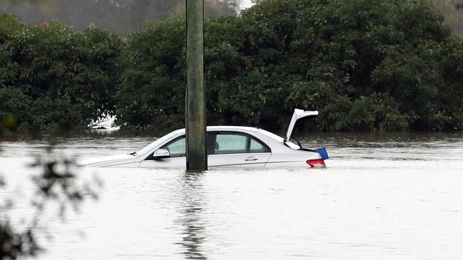
Dozens of roads continue to be closed across the state and the Queensland Ambulance Service says it has responded to at least two rescues from cars stuck in floodwaters.
In Central Queensland, two patients, a woman in her 30s and a young child, were taken to Emerald Hospital after being stuck between rising flood waters on the Capricorn Highway near Glenlee Rd about 6pm.
In Brisbane, paramedics and other emergency services were called to a man stuck in floodwaters in his vehicle on Oxley Golf Driving Range Access Rd at 4.20am.
He was rescued safely and declined QAS assessment.
The Bureau issued a minor flood warning for Brisbane City on Thursday afternoon, with people in the Sunshine Coast and Noosa told to prepare for intense rainfall and potentially dangerous flooding throughout Friday.
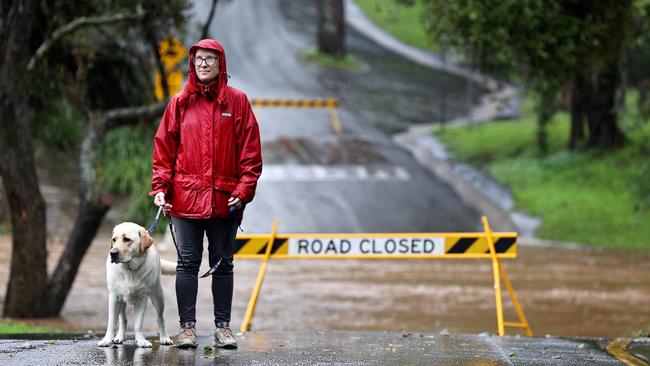
Roads around the South East are closed.
A 36-year-old man and his dog were found well on Thursday after they went missing from a campsite at Imbil, which was isolated due to flooded river crossings.
Meanwhile, a group of farmers rescued a man who was stranded and clinging to a tree in floodwaters in the Bundaberg region.
Emergency services were also called West Ipswich to assist two people after they became trapped in floodwaters, but they were saved by passers-by when one of the occupants climbed on to the roof of their car to attract attention.

An initial flood watch was issued for the Wide Bay and Burnett, Southeast Queensland, Darling Downs and Granite Belt areas, but meteorologist Brooke Pagel said the weather system was unlikely to bring a repeat of the widespread and destructive floods of February.
The BOM’s Ms Pagel said the risk of major flooding along the lower Brisbane River was significantly less than in late February because the fast-moving weather system was expected to ease by Saturday.
“The rain and the catchments that are really in focus at the moment … is actually out at Lockyer Valley around Gatton and Laidley Creek,” she said.
“But for Brisbane itself and even outer Brisbane, regions like The Gap and Moggill, it doesn’t look like there will be any major flooding for those catchments.”
Lockyer Valley Regional Council urged households at risk of being cut off to have at least three days’ worth of vital supplies on hand, avoiding the need to call for essentials.
Mayor Tanya Milligan said it was a blessing that she was yet to receive reports of homes flooding on Thursday afternoon, and hadn’t received any requests to open the evacuation centre.
“While I say there’s no inundation in homes, there is certainly water in people’s yards,” she said.
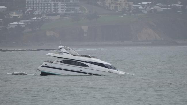
In Rockhampton, a multimillion-dollar super yacht that smashed into the Capricorn Coast on Wednesday afternoon began sinking after its anchor lost hold during the rough conditions.
It was believed the yacht was available to be rented through online platform Airbnb for about $14,000 a week for 12 guests, with its owners based on the Gold Coast.
Brisbane’s May rainfall totalled more than 110mm by Thursday afternoon, with up to 60mm forecast for Friday and 15mm on Saturday. It’s been seven years since May rainfall in Brisbane reached that total.
Ms Pagel said it was the wettest May for Queensland in five to eight years. Brisbane has so far received more than 1.3m of rain this year, the Gold Coast 1.2m and the Sunshine Coast 1.38m.
While May records have been broken, this week’s severe weather brought significantly less rain than the stubborn trough, which flooded homes across the southeast earlier this year.
The river city recorded 887mm for February, while 699mm fell on the Sunshine Coast and 409mm on the Gold Coast.
Ms Pagel said the slow-moving troughs that dumped huge totals across Queensland earlier this year behaved differently to this weather system.
“One was an embedded tropical low, another was a stagnant trough that hovered over the area for days, which caused all that (Brisbane) River flooding, and the Maryborough one was stagnant and it bucketed down for days over one area,” she said.
“With this one, all the rain we received on Thursday is what Mackay and Cairns received on Wednesday, which indicates it is quite fast-moving. By Saturday, it’s only suggesting 15mm, which indicates this will move offshore quite quickly.”
Up to 60mm of rain is expected for Brisbane on Friday, 80mm for Gatton, 45mm for the Gold Coast, 90mm for Maleny and 100mm for Bundaberg.
Ms Pagel said a prolonged La Nina meant Queensland experienced a late wet season.
The BOM on Thursday released its Climate Model Summary, which revealed La Nina was persisting, but should return to neutral-ENSO by July.
School closures
Abercorn State School
957 Wuruma Dam Road
Allora P-10 State School
21 Warwick Street
Applethorpe State School
25576 New England Highway
Aratula State School
41 Elizabeth Street
Begonia State School
4233 Begonia Rd
Blenheim State School
81 Blenheim Road
Boonah State High School
32 Macquarie Street
Boonah State School
Park Street
Bowenville State School
Irvingdale Road
Builyan State School
Gladstone Road
Clarendon State School
507 Clarendon Road
Coominya State School
7 Cornhill Street
Dallarnil State School
3 Main Street
Darlington State School
2744 Kerry Road
Dirranbandi P-10 State School
Jane Street
Drillham State School
13 Jardine Street
Flagstone Creek State School
56 Flagstone School Road
Forest Hill State School
Church Street
Freestone State School
82 School Road
Glamorgan Vale State School
750 Glamorgan Vale Road
Glen Aplin State School
54 Mount Stirling Road
Glenmorgan State School
Clive Street
Glenore Grove State School
3 Brightview Road
Grantham State School
15 Victor Street
Greenlands State School
1209 Texas Road
Harrisville State School
17 Hall Street
Hatton Vale State School
Hannant Road
Helidon State School
16 School Street
Hillview State School
1623 Christmas Creek Road
Kalbar State School
George Street
Karara State School
Karara School Road
Kentville State School
Turpin Road
Killarney P-10 State School
Acacia Street
Laidley District State School
232 Patrick Street
Laidley State High School
98 Alfred Street
Lake Clarendon State School
35 Lake Clarendon Road
Lockrose State School
17 Zabel Road
Lowood State High School
Prospect Street
Lowood State School
Peace Street
Ma Ma Creek State School
803 Gatton-Clifton Road
Maroon State School
2772 Boonah-Rathdowney Road
McIlwraith State School
322 McIlwraith Road
Minden State School
1032 Lowood-Minden Road
Moonie State School
11305 Moonie Highway
Mount Alford State School
942 Reckumpilla Street
Mount Crosby State School
Mount Crosby Road
Mount Kilcoy State School
251 Jenkinsons Road
Mount Sylvia State School
6 Left Hand Branch Road
Mount Tarampa State School
9 Profkes Road
Mount Whitestone State School
1313 Gatton-Clifton Road
Murray’s Bridge State School
1378 Killarney Road
Patrick Estate State School
816 Mahon Road
Peak Crossing State School
Ipswich-Boonah Road
Prenzlau State School
357 Prenzlau Road
Rathdowney State School
Mount Lindesay Highway
Tamrookum State School
9019 Mount Lindesay Highway
Tarampa State School
18 Manthey Road
Teelba State School
Teelba Road
Tent Hill Lower State School
90 Lower Tenthill Road
Thallon State School
15 Henry Street
Thornton State School
4 Thornton School Road
Wallaville State School
7 Grey Street
Warrill View State School
Cunningham Highway
Wartburg State School
585 Coast Road
Warwick East State School
45 Fitzroy Street
Withcott State School
26 Biggs Road
Yangan State School
King Street
Catholic and independent school closures
Silver Lining School (Ficks Crossing)
14722 Bunya Highway
The Kooralbyn International School (Kooralbyn)
Ogilvie Place
The River School (Maleny)
251 Bridge Creek Road
Read related topics:Weather
Aussies to face one of warmest winters ever
Aussies could bake through one of the warmest winters on record, with temperatures expected to soar above average across the nation.
Read more

Horror, heartache of record flood recovery as livestock wash up near homestead
An Outback Queensland grazier still unable to leave her property after 500mm of rain over two weeks has revealed the reality of cleaning up after record-breaking rain.
Read more