
Condamine River at Warwick surpasses devastating 2013 flood levels, expected to peak near 2011
Warwick residents have endured another significant round of flooding, but predicted record-breaking heights have been avoided and the damage begins to be uncovered. Latest details:
Warwick
Don't miss out on the headlines from Warwick. Followed categories will be added to My News.
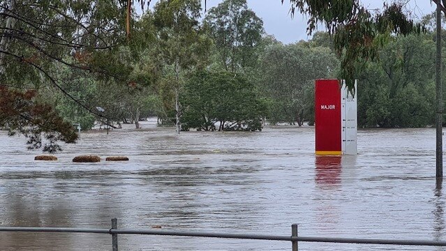
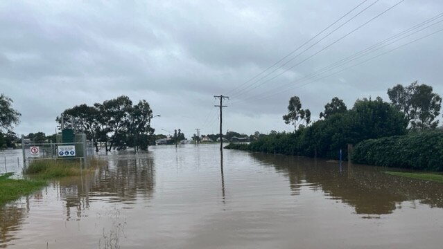
The Condamine River at Warwick has peaked at 7.5m overnight, avoiding predicted record-breaking levels but causing widespread chaos and loss.
The main thoroughfare of the Rose City remains closed at OO Madsen Bridge, with Department of Transport and Main Roads engineers at the scene this morning to assess damage.
Southern Downs Regional Council said a decision on whether to open the bridge was imminent.
“This inspection is to ensure that the bridge has remained structurally sound, all debris has been removed and that it is safe to open for traffic,” a spokesman posted to social media.
The river sits at just under 6m at 9.30am Saturday, dropping significantly since peaking about 5.30pm Friday.
Experts had earlier warned Warwick residents and business owners to prepare for the Condamine River to peak at a flood height just below that recorded in the devastating 2011 flooding event.
The Bureau of Meteorology predicted the Condamine River at Warwick would peak at about 8.2m between 6pm and 8pm Friday, with the river at 7.56m and still rising as of 2.36pm.
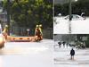
Southern Downs Regional Council and SES crews doorknocked to inform the residents likely to be impacted, and WIRAC was opened to the community as an evacuation centre.
The flood levels were above those recorded during the 2013 floods, with BOM meteorologist Helen Reid saying the Condamine River earlier predicting it would likely push above 8m with further significant rainfall expected on Friday afternoon.
“At the moment the rainfall and heavier stuff is to the north, so it’s just a matter if Warwick and that area right on the border catches it,” she said.
“It could be another 100mm or something like that, which will make those rivers a lot worse, but it will depend on whether you just catch the end of that band of rain there or whether it goes right over the top of you.
“We have had a lot of rain up to that saturated catchment there, and I would be suggesting that (this flood) was definitely one to notice as ‘the floods of 2022’.
“It’ll be what you remember to tell people about all those decades later.”
It is the consequences of previous memorable and devastating flood events that Warwick business owners are trying to avoid, with those at the east end of Albion St and along Canning and Fitzroy Sts historically suffering major damage during the 2010-11 and 2013 floods.
B&K Motors owner Dave Kemp said it was the horror caused by the 2011 floods that prompted him to install flood barriers to protect his workshop, which he managed to put up just in the nick of time on Friday morning.
“That little bit of time this morning should save a lot of grief hopefully, so long as it doesn’t go over the barriers. There’s a little bit of water coming in, but the pump is getting it out again,” he said.
“So long as (the river) doesn’t go much over 8.5m, I should be safe from having the whole workshop flooded, for which I’m a lot more fortunate than others down there.
“I think it’s business as usual for most of the town, because the people who live out in west Warwick don’t know that it’s flooding and we’ve still had people coming in this morning for their work to be done.”
With this at least the fourth flood event Warwick has experienced within the past six months alone, Mr Kemp said any notable rainfall was now a cause for concern.
“The thing is that every time it rains heavily, we dread this is going to happen, and it’s happened now,” he said.
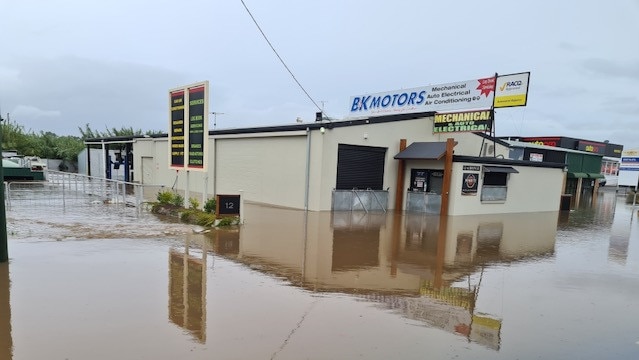
“It’s never a good thing when it’s raining and you just wonder whether you’re going to be flooded in the next day, but there’s nothing much you can do now.
“Hopefully we’ve dodged a major bullet so we can clean up on Sunday and get back into work on Monday, because this puts us back in work and we’re already so busy as it is.”
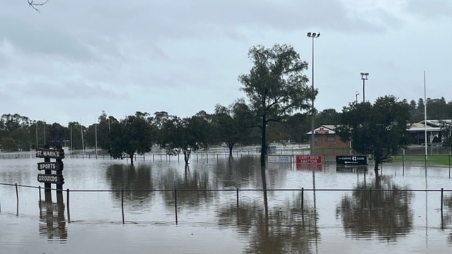
Warwick East State School and Scots PGC College have reported significant flooding throughout their campuses, and the sports fields across Queens Park and its surrounds are largely underwater.
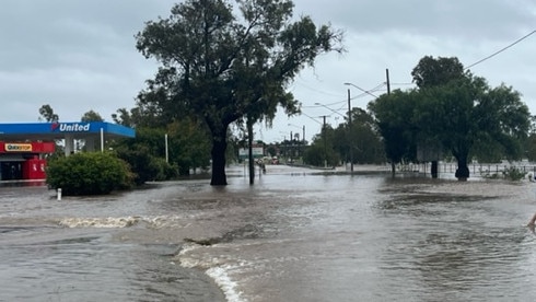
Businesses along the main street of Killarney were also swamped by floodwater overnight, and much of the town is remains cut off on Friday.
The major floods come after parts of the region received close to 300mm of rain in the 24 hours from 9am Thursday.
BOM rain gauges at Spring Creek recorded a whopping 290mm within that time period, with another 210mm at The Head, 179mm at Carrs Lookout, and 156mm at Queen Mary Falls.
Other huge 24-hour totals include 91mm at Cherrabah, 78mm at Connolly Dam, and 69mm at Warwick.
The huge flood levels have closed several major routes through Warwick including the O.O. Madsen Bridge connecting the town to the Cunningham Hwy and the McCahon Bridge on Victoria St.
Southern Downs Mayor Vic Pennisi said he expected three gates to open at Leslie Dam to release water from the above-capacity dam, with overflows to continue from Connolly and Storm King Dams.
“We’ll set up some evacuation centres if necessary, but they are basically the last resort,” he said.
“If it’s flooded, forget it – that’s the number one rule. The second thing is it’s now going to take us two years to repair the damage, and there’s nothing that I can do about that.
“We can’t stop the drought and we can’t switch the rain off, and the long-term benefits (of it) will be fantastic, but we’re going to suffer some pain and we don’t know the full extent at this stage.”
Mr Pennisi said further evacuation centres and emergency aid may be necessary depending on whether the intense rainfall predicted for Friday afternoon and evening eventuated.
“Those people that are in the flood zone, my heart goes out to them, I can’t begin to imagine what they’re going through,” he said.
“I just feel so sorry for those people and they must be going through a lot of stress at this point in time, but as a community, we will pull together and we will recover from this as well.
“Every rain event is different, and we will have a debrief at the end of this to see if there’s something we could have done better, something we should have done, or something we forgot to do, and we’ll keep improving the way we put these things together.”
Warwick East State School, Allora P-10 State School, Freestone State School, Karara State School, Killarney P-10 State School, Murrays Bridge State School, Yangan State School, Applethorpe State School, Glen Aplin State School, and Greenlands State School have all closed for Friday due to the flood event.
More than 70 roads across the region have already been cut off by floodwaters, with more expected to close as the Condamine River continues rising and significant rain drives further flash flooding.
See the full list of road closures listed by SDRC below:
Cunningham Hwy at Warwick, Clintonvale, Tregony
New England Hwy, Glengallan
Park Rd, Warwick
Victoria St, Warwick
Rosehill Rd, Warwick
East St, Warwick
Grafton St, Warwick
Percy St, Warwick
Fitzroy St, Warwick
Jackie Howe Dr, Warwick
McEvoy St, Warwick
Warwick Allora Rd, Warwick
Leslie Dam Rd, Allan/Rosenthal Heights
Lyndhurst Lane, Rosenthal Heights
Homestead Rd, Rosenthal Heights
Connolly Dam Rd, Rosenthal Heights
Frees Rd, Womina
Myrtle Hill Rd, Freestone
Freestone Rd, Clintonvale
Condamine River Rd, Killarney
Backhouse Rd, Killarney
Warwick Killarney Rd, Killarney
Swan Creek School Rd, Swan Creek
Murphy Rd, Swan Creek
Jack Smith Gully Rd, Swan Creek
Cullendore Rd, Murrays Bridge
Junabee Rd, Junabee
Strudwick Rd, Yangan
Yangan Killarney Rd, Yangan
Connells Bridge Rd, Bony Mountain
Old Stanthorpe Rd, Wildash
Tralee Rd, Pratten
Big Hill Rd, Pratten
School of Arts Rd, Pratten
Doyle Rd, Gladfield
Clintonvale Goomburra Rd, Gladfield
Inverramsay Rd, Goomburra
Forest Springs Goomburra Rd, Goomburra
Toolburra Plains Rd, Toolburra
Kirkland Rd, Massie
Massie Bony Mountain Rd, Massie
Hermitage Emu Vale Rd, Danderoo
Shannon Rd, Allora
Merivale St, Allora
Kital Rd, Berat
Talgai W Rd, Talgai
Wheatvale Plains Rd, Upper Wheatvale
Tummaville Rd, Leyburn
Amosfield Rd, Dalcouth
Dalcouth Rd, Dalcouth
Britannia St, Stanthorpe
Lock St, Stanthorpe
Folkstone St, Stanthorpe
Granite St, Stanthorpe
West Rd, Stanthorpe
Aerodrome Rd, Applethorpe
Border Rd, Applethorpe
Reid Rd, Severnlea
Maryvale St, Hendon
Elks Ln, Broadwater
Spring Creek Rd, Amiens
Amiens Rd, Thulimbah
Residents impacted by flooding should call the SES on 132 500 for assistance or emergency services on triple-0 in life-threatening situations.

Join the conversation

Drink or drug drivers taken off Toowoomba roads in July
Live list: Each month, dozens of Toowoomba drivers front court for drink or drug driving. Here’s a list of locals who’ve lost their licences for the offence so far this month.
Read more

Meet some of the young stars taking the stage for CGEN 2025
Curtains will go up on Friday with 2000 students from Queensland taking to the stage for Creative Generation (CGEN) after months of preparation and rehearsals.
Read more