
Qld’s severe weather stranglehold: 1000mm deluge and cyclone loom
Ex-tropical cyclone Kirrily has dumped 340mm in just 24 hours as it starts to track south, while the chances of another cyclone forming off the Qld coast have increased overnight.
QLD weather news
Don't miss out on the headlines from QLD weather news. Followed categories will be added to My News.
Ex-tropical cyclone Kirrily has dumped 340mm of rain in just 24 hours as the system begins to track towards southwest Queensland, while the chances of a new cyclone firming off the coast increase.
Flood and severe weather warnings have been issued for communities in the path of the low, with areas in north and northwest Queensland bracing for heavy rainfall that may lead to flash flooding.
Falls exceeding 300mm over 24 hours are possible, along with damaging wind gusts up to 110km/h.
Bureau of Meteorology senior meteorologist Brooke Pagel said flooding was the main concern for authorities.
“The issue is it gets into catchments and flows downstream so we also have moderate flood warnings for the Georgina and Diamantina River and major flooding in the Flinders river downstream of Richmond,” she said.
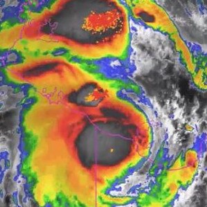
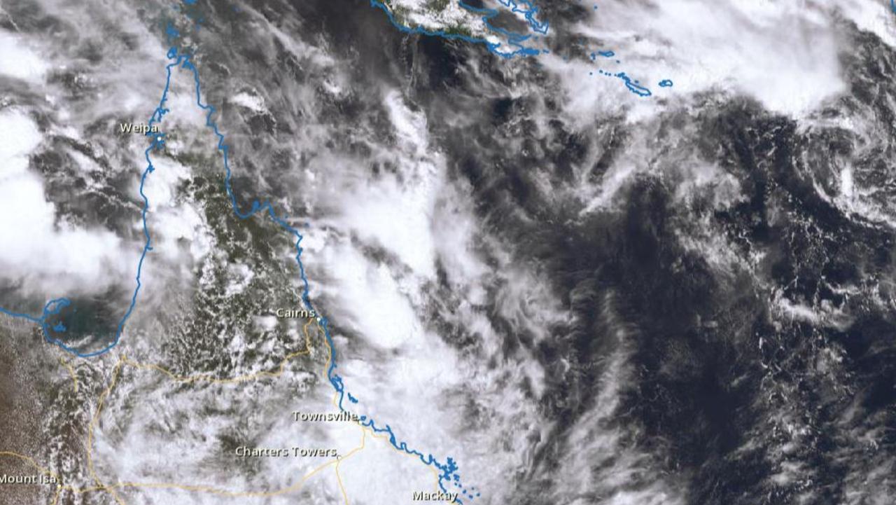
Meanwhile, the chances of a low in the Coral Sea developing into a cyclone next week has increased overnight to moderate (25 per cent).
“While it’s still a tropical low in the Coral Sea moving north east away from the coast, there’s still an increasing chance it may develop into a tropical cyclone from Wednesday or Thursday next week,” she said.
Ms Pagel said the system was sitting 933km east of Mackay.
“People should keep watching out for updates because we will soon have more of an idea on whether it will impact the Queensland coast and when,” she said.
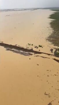
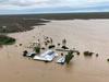
The relentless system that was topical cyclone Kirrily has left major highways cut off, train services stopped and residents clearing supermarket shelves with fears of long periods of isolation.
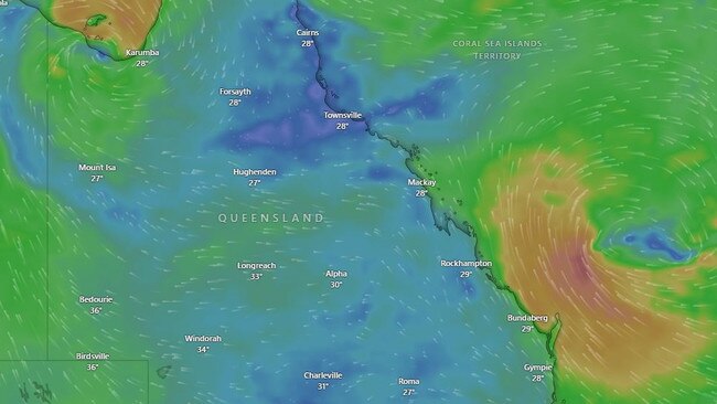
Residents between Burketown to Birdsville have been warned of possible daily rainfall totals exceeding 300mm, with the potential for some areas to see up to 1000mm after being battered for several days.
Several flood watch warnings remain active for places along the Leichhardt and Flinders River, with the Cloncurry River also experiencing moderate flooding and the Georgina River and Eyre Creek being closely monitored.
Bureau of Meteorology Senior Meteorologist Patch Clapp said most western catchments still had some capacity to take on further falls, but life-threatening flash flooding was likely with six-hourly rainfall totals of 150-200mm forecast.
“Major flooding is also occurring in Diamantina Lakes, similar to the 1999 flood level,” he said.
The Diamantina River at Birdsville is likely to reach the minor flood level of 4m in the coming days, before rising to 6m the following week.
Four major roads have so far been closed, including the Flinders Highway between Cloncurry and Julia Creek and the Landsborough Highway between Winton and Cloncurry.
The lingering low impacted the rail network, with parts of the Mount Isa line now cut off by floodwaters and the Central West line closed in multiple directions, with Inlander train services cancelled.
Mount Isa resident Dan Ballard said supermarket shelves had been stripped bare and he hoped retail giants would organise resupply fly-ins, with freight routes now cut-off by floodwaters.
“There’s a strong reaction when there’s rain because we’re so prone of impacts, and we’re isolated,” he said.
“I’ve never heard of those (rainfall) figures Western Queensland for a year, (let) alone a month or days.”

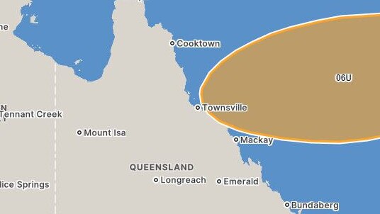
On the opposite side of the state, a subtropical low looms off the Central Coast.
The Bureau has warned the system could develop into a tropical cyclone next week, before possibly tracking back towards the coast anywhere near Cooktown and Mackay.
It would be the third tropical cyclone to threaten the north coast since December.
“The likelihood for 06U to develop into a tropical cyclone increases to 10-15 per cent from Wednesday onwards but may be outside the Australian region as there is a considerably large spread in area where 06U may move mid-to-late next week,” the Bureau said.
“Possible scenarios include a westwards movement back towards the Queensland coast by late next week.”
More Coverage


Piles of heartbreak: Ingham counts devastating cost of floods
The Hinchinbrook region has begun counting the cost caused by the “perfect storm” as talk turns to potential buybacks and re-building homes ravaged by the floods.
Search for man missing in flood waters as NQ faces another 300mm monster
A search and rescue mission is underway in NQ for a man who drove into flood waters while the region braces for an active monsoon trough expected to dump falls of up to 300mm.