
Ex-Cyclone Kirrily to dump 1000mm rain onto Qld outback
Queensland’s outback is set to become a vast inland sea, as ex-tropical cyclone Kirrily shapes to dump 1000mm rain in 48 hours.
QLD weather news
Don't miss out on the headlines from QLD weather news. Followed categories will be added to My News.
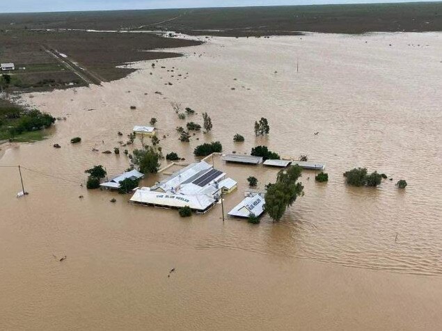
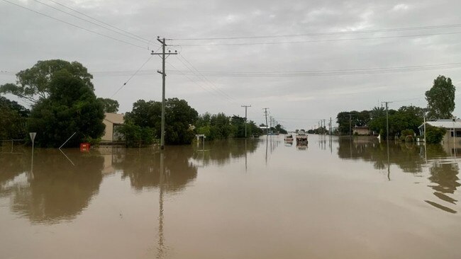
Major highways have closed, train services cancelled and panic buying has started as Ex-Tropical Cyclone Kirrily brings major flooding to North West Queensland, with a further 1000mm of rainfall forecast to lash the area in coming days.
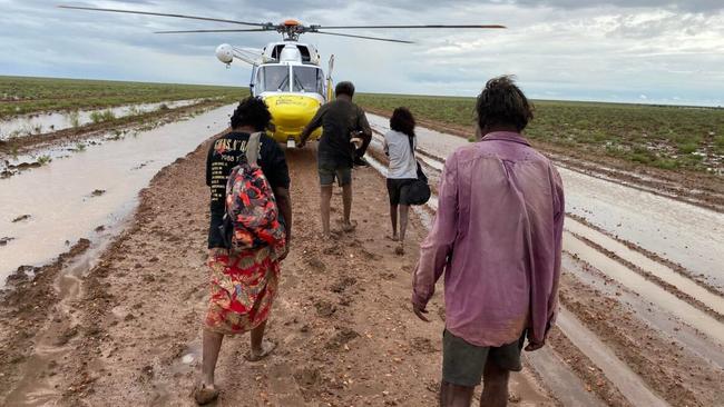
It comes as a video of two people being washed away in the Cloncurry River in a tinnie emerged on Thursday.

Life-threatening flash flooding is forecast to impact areas between Burketown right down to Birdsville over the next few days as the low tracks south through Western Queensland towards the South Australia and New South Wales borders.
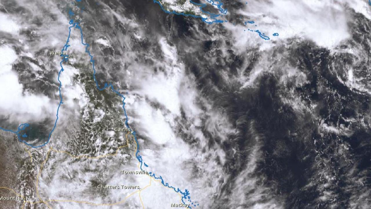
The Bureau of Meteorology has issued a severe thunderstorm warning for heavy rainfall and damaging winds for residents in parts of Gulf Country and North West where Ex-TC Kirrily is sitting.
Bureau of Meteorology Senior Meteorologist Patch Clapp said the system is forecast to begin moving south from Friday.
Several flood watch warnings are in place for areas long the Leichhardt River (Mount Isa), Nicholson and Settlement Creek.
Mr Clapp said most catchments in the west still had some capacity to take on further falls, but life-threatening flash flooding was likely with isolated fall reaching 300mm within 24-hour periods.
“There's still a little bit of capacity in the northeast most rivers,” he said.
“Flinders River downstream from Richmond is experiencing major flooding, Georgina River and Ayr Creek are on flood watch with both just under the flood watch level.
“Minor flooding is occurring in the Cloncurry.
“There’s also a flood warning out for the Diamantina River as well, with major flooding occurring in Diamantina Lakes, similar to the 1999 flood level.”
Flooding is expected to reach Birdsville next week, as Diamantina catchments drain south.
The Bureau is forecasting six-hourly totals of between 150-200mm and totals exceeding 300mm in 24 hours.
“300mm is certainly a lot of rainfall and potential dangerous and life-threatening flash flooding is coming from that,” Mr Clapp said.
Two people have so far been rushed to hospital after their car was washed away in flood waters on Wednesday.
Queensland Ambulance confirmed one person was taken to Cloncurry Hospital with a head injury and another to Mount Isa Hospital in a serious condition after their vehicle became trapped in floodwaters near Fort Constantine.
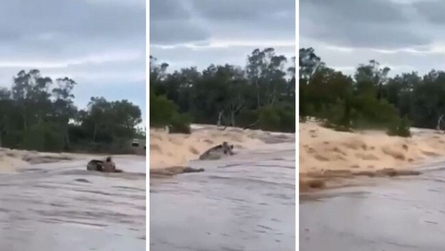
In an unrelated incident, footage has emerged of a man driving alongside the Cloncurry River which is currently experiencing minor flooding.
The man appears to then film two people in a tinnie being washed away in strong currents.
The man behind the camera can be heard saying, “oh no, they’re gone”.
The Courier-Mail understand the two men involved are unharmed, with Queensland Fire and Emergency Services confirming no swift water rescues have been conducted in the area.

Four major roads have so far been closed due to ongoing flash flooding, including the Flinders Highway between Cloncurry and Julia Creek, the Landsborough Highway between Winton and Cloncurry, Wills Developmental Rd from Julia Creek to Burke and Wills Junction and the Burke Developmental Rd from Normanton to Karumba.
The lingering low has also impacted the rail network, with parts of the Mount Isa line now cut off by floodwaters and the Central West line closed in multiple directions.
Queensland Rail Head of Regional Scott Cornish said Kirrily said the North Coast line between Brisbane and Cairns remained open.
“The Mount Isa line, however, is closed west of Julia Creek due to severe flooding at McKinnons Creek,” he said.
“While the water has subsided, the track has been damaged and the railroad has been eroded by flowing water.
“With more rain expected in the region, it’s possible the water levels could rise again.”
Mr Cornish said damage to the Central West line would be inspected when it was safe to do so.
“Queensland Rail understands the importance of moving freight around our state and we are working with freight partners who are affected by these track closures,” he said.
The Inlander train service has been cancelled, while the Westlander and Spirit of the Outback services will operate as planned.
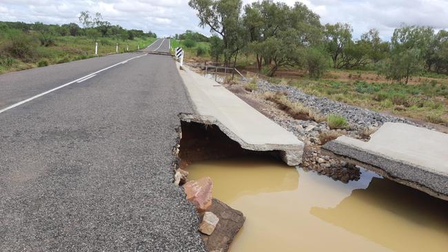
Transport and Main Road (TMR) crews are also inspecting major damage at Wild Duck Creek between Kynuna and McKinlay.
Mount Isa resident Dan Ballard said supermarket shelves in the town had been stripped bare, as locals prepared for further flooding onslaught.
Mr Ballard said he hoped supermarkets would organise resupply fly-ins, with freight routes now cut-off by floodwaters.
“There’s a strong reaction when there’s rain because we’re so prone of impacts, and we’re isolated,” he said.
“I’ve never heard of those (rainfall) figures Western Queensland for a year, (let) alone a month or days.
“It’s impossible to get out of town east through Cloncurry already.
“We’ll start to see supplies flown in hopefully supermarkets will have to make a decision about that in the next few days.”

Chief forecaster for Higgins Storm Chasing Thomas Hinterdorfer said falls between 250mm and 500mm were likely, with some areas possibly revving 1000mm of rain.
Higgins has forecast the low to intensify during Friday and Saturday before tracking back South again past Mount Isa, producing rainfall totals of up to 1000mm.
“Rainfall totals of 250-500mm are likely with falls as high as 1000mm possible due to the track north then back south,” Mr Hintendorfer said.
“Locations likely to be impacted include Montt Isa, Cloncurry, Gun Powder, Three Rivers, Four Ways, Gidya, Gregory and Burketown, possibly Normanton, Karumba and Doomadgee.
“The Flinders and Leichhardt catchments could see record-breaking flooding.”
The Bureau said the Diamantina River at Birdsville is likely to reach the minor flood level of 4 metres during the weekend or early next week, with further rises expected.
“The river may reach the moderate flood level (6.0 m) into the following weekend beginning Saturday, February10,” the Bureau said,
“Birdsville reached the moderate flood level in both 2022 and 2023.”
Road closures due to flooding:
• Flinders Highway between Cloncurry and Julia Creek (due to flooding Gilliat Channels)
• Landsborough Highway between Winton and Cloncurry
• Wills Developmental Road from Julia Creek to the Burke and Wills Junction
• Burke Developmental Road from Normanton to Karumba
Cloncurry road closures and restrictions:
Kuridala / Opalton – Cloncurry Shire / Winton Shire Landsborough Highway Flooding Closures – Road closed to all traffic
Four Ways / Julia Creek – Cloncurry Shire / McKinlay Shire Wills Developmental Road Flooding Closures – Road closed to all traffic
Cloncurry / Duchess – Cloncurry Shire Cloncurry Duchess Road / Duchess Dajarra Road Flooding Closures – Road closed to all traffic
Cloncurry / Julia Creek – Cloncurry Shire / McKinlay Shire Flinders Highway Flooding Closures – Road closed to all traffic
Four Ways / Stokes – Carpentaria Shire / Cloncurry Shire Burke Developmental Road / Wills Developmental Road Flooding Closures – Road closed to all traffic
Duchess / Kuridala – Cloncurry Shire Cloncurry Duchess Road Flooding Lanes affected – All lanes affected
Dajarra / Waverley – Cloncurry Shire Diamantina Development Road Flooding Lanes affected – All lanes affected
Dajarra – Cloncurry Shire Urandangi South Road Flooding Road restricted – Restricted to four wheel drive vehicles only
More Coverage

Read related topics:Weather
Join the conversation

Piles of heartbreak: Ingham counts devastating cost of floods
The Hinchinbrook region has begun counting the cost caused by the “perfect storm” as talk turns to potential buybacks and re-building homes ravaged by the floods.
Read more
Search for man missing in flood waters as NQ faces another 300mm monster
A search and rescue mission is underway in NQ for a man who drove into flood waters while the region braces for an active monsoon trough expected to dump falls of up to 300mm.
Read more