
Queensland in line for third cyclone of season as tropical low forms in Coral Sea
Forecasters tracking a low in the Coral Sea say that likelihood of a cyclone forming off the Queensland coast has increased.

QLD weather news
Don't miss out on the headlines from QLD weather news. Followed categories will be added to My News.
The likelihood a new tropical cyclone could form off the Queensland coast as early as next Tuesday has increased, the Bureau of Meteorology has warned.
On Wednesday afternoon, a low that has recently formed over the Coral Sea along the subtropical part of the Queensland coast was given a 10 per cent chance of forming into a tropical low and then a tropical cyclone from next week.
However, on Thursday morning, forecasters said that likelihood had increased to 15 per cent, with updated modelling showing it will drift over the Coral Sea and strengthen.
It would be the third tropical cyclone to threaten Queensland during the 2023-24 season.
Senior Meteorologist Harry Clark said the subtropical low’s chance of forming into a tropical low and then strengthening to a cyclone had risen from 10 per cent to 15 per cent over the past 24 hours.
“Our models show this system could drift back out to the Coral Sea where it will strengthen from Wednesday,” Mr Clark said.
“Beyond that we are uncertain but it is something we are keeping a very close eye on.”
Early Warning Network meteorologist Kent Kato said the subtropical low had been in their modelling for a time.
“It’s currently sitting in the southwestern part of the Coral Sea roughly 500km off Gladstone,” he said.
“Once it gets further out and further north it could strengthen.
“After about Wednesday the possibilities are spread like a dog’s breakfast, it could come closer to the Queensland Coast or go well out to sea.”
Ex-Tropical Cyclone Kirrily is bringing more rain to far north-west #Queensland, before making a sharp turn and heading into the centre of the country this weekend. Latest forecasts and warnings: https://t.co/4W35o8i7wJpic.twitter.com/raoopGHc5K
— Bureau of Meteorology, Australia (@BOM_au) January 31, 2024
Bureau meteorologist Steve Haidley said Queensland was now heading into the “peak” of cyclone season, with some models suggesting the low could remain in the Coral Sea, and others forecasting it to move east towards the coast.
Mr Haidley on Wednesday said the low was weak and had been formed by a trough in the subtropics, hundreds of kilometres from the Queensland coastline.
“The tropics is the north of the tropic of Capricorn which is level or just north of Rockhampton,” he said.
“If given time over warmer waters we could see thunderstorms rotating around it and the potential for it to form into a tropical cyclone.”
Meanwhile, Ex-Tropical Cyclone Kirrily is forecast to start tracking south towards the state’s western corner.
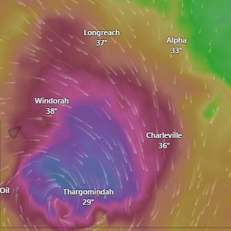
Mr Haidley said the tropical low had been “really persistent” and was still dumping heavy rain on all areas in its path.
The system will continue moving west over the next couple of days, before heading south over the weekend, with the potential to develop into a deeper low pressure system.
“In the longer term, all models suggest it will move southward,” Mr Haidley said.
“Mount Isa could see a brief improvement with rain shifting north, but it will come back through their way and towards southwestern Queensland this weekend.
“Storms will reach the Channel Country, with Birdsville to see storms on Sunday and then that low pressure system takes a dive into New South Wales.”
Strong winds are forecast to first impact the Gulf Country, with the tropical low bringing chilly temperatures that could threaten livestock.

Feels like -5.3C: Icy blast sends temps plummeting again
South East Queensland has again shivered through a freezing start to the day, as a brutal cold front continues to blast the region with subzero temperatures, made worse by chilling winds.

Feels like MINUS 7.1C: Brutal cold front blasts southern Qld
A brutal cold front is blasting across southern Queensland with subzero temperatures and widespread frost.