
Cyclone Jasper safety guide: forecast, BOM track map & road closures
Cyclone Jasper made landfall on Wednesday night. Here is everything you need to know and the latest warnings and advice from the Bureau of Meteorology.
QLD weather news
Don't miss out on the headlines from QLD weather news. Followed categories will be added to My News.
Cyclone Jasper is set to make landfall on December 13. We’ve listed everything you need to know to prepare for the cyclone and the latest warnings and advice from the Bureau of Meteorology.
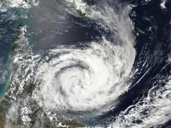
Cyclone Jasper hits: Destructive winds, 500mm deluge, flash flooding expected
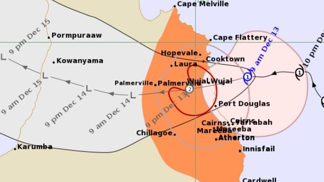
CYCLONE TRACKER: MONSTER STORM’S 500MM DELUGE
CYCLONE FORECAST
Tropical Cyclone Jasper, a Category 2 system, is producing damaging to destructive wind gusts to the Far North Queensland coast as it makes landfall in the vicinity of Wujal Wujal, just north of Cape Tribulation. Jasper is expected to weaken overnight as it moves inland.
At 7pm Wednesday:
Intensity: Category 2, sustained winds near the centre of 95 kilometres per hour with wind gusts to 130 kilometres per hour.
Location: Within 20 kilometres of 15.9 degrees South 145.4 degrees East, estimated to be 115 kilometres north northwest of Cairns and 55 kilometres south southeast of Cooktown.
Movement: West at 11 kilometres per hour..
Latest warning:
Locally INTENSE RAINFALL which may lead to DANGEROUS AND LIFE-THREATENING FLASH FLOODING is forecast to develop from tonight along the coast and adjacent ranges between Cape Tribulation to Cairns as well as areas near the centre of Tropical Cyclone Jasper. Isolated six-hourly rainfall totals between 250 to 300 mm are likely with 24-hourly totals between 400 to 500 mm possible.
HEAVY RAINFALL which may lead to FLASH FLOODING is also forecast to develop between Cape Flattery and Ingham. Six-hourly rainfall totals between 100 to 150 mm are likely, with isolated falls up to 250 mm along the coast and adjacent ranges. 24-hourly rainfall totals between 150 to 250 mm are likely, with isolated falls up to 350 mm possible.
Please refer to Severe Weather Warning for HEAVY, LOCALLY INTENSE RAINFALL and DAMAGING WINDS for people in parts of Peninsula, Gulf Country and Northern Goldfields and Upper Flinders Forecast Districts.
DESTRUCTIVE wind gusts of up to 140 km/h are expected near and to the south of the track between Wujal Wujal and Port Douglas.
GALES with DAMAGING WIND GUSTS of up to 120 km/h are occurring along the coast south of Cooktown, including Cairns.
DAMAGING WIND GUSTS are expected to extend further along the coast and adjacent ranges between Cooktown and Innisfail in the evening. Damaging wind gusts to 90 km/h are possible further south to Cardwell and north to Cape Melville, and then extending inland to the Atherton Tablelands and as far as Palmerville and Chillagoe tonight, after the cyclone has crossed the coast.
Along the track of the cyclone, the DAMAGING WIND GUSTS may temporarily eased to lighter winds as the eye of the cyclone passes over.
Flood watches and warnings are current for the North Tropical Coast, parts of the Cape York Peninsula and Gulf Country.
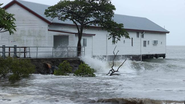
A storm tide is expected along the north Queensland coast on the high tide during Thursday morning with total waters generally expected to approach or marginally exceed the Highest Astronomical Tide level. Large waves may produce minor flooding along the foreshore.
Cyclone Jasper: FNQ residents in waiting game as tropical storm nears
ROAD CLOSURES AND PREPARATIONS
Hazard: Adverse driving conditions
Mossman Mt Molloy Road (Rex Highway)
Julatten / Shannonvale
Rex Range CLOSED due to Cyclone Jasper
Hazard: Adverse driving conditions
Kennedy Highway
Kuranda / Macalister Range
Kuranda Range CLOSED due to Cyclone Jasper
Hazard: Adverse driving conditions
Captain Cook Highway
Craiglie / Palm Cove
Road Closed Port Douglas to Palm Cove due to Cyclone Jasper
Hazard: Adverse driving conditions
Peninsula Developmental Road
Shephard Street
Coen / Laura / Mission River
ROAD OPEN WITH CAUTION - Laura to Weipa
Hazard: Adverse driving conditions
Burke Developmental Road
Chillagoe / Maramie
ROAD OPEN WITH CAUTION - Chillagoe to Mareeba Shire Council Boundary
Hazard: Adverse driving conditions
Gregory Developmental Road
Einasleigh / Mount Surprise
ROAD OPEN WITH CAUTION - Einasleigh to Gulf Developmental Rd
Hazard: Adverse driving conditions
Gillies Range Road
Lake Barrine / Little Mulgrave
Gillies Range CLOSED due to Cyclone Jasper
Hazard: Debris on road
Macrossan Street
Port Douglas
Hazard: Bridge or culvert damaged
Peninsula Developmental Road
Laura
Damaged Barrier - Cattle Creek Bridge
Hazard: Debris on road
Kennedy Highway
Kuranda
Fallen tree near Greenhills Road
Hazard: Debris on road
Glen Allyn Road
Malanda
Tree over road
Hazard: Debris on road
East Evelyn Road
Evelyn / Millaa Millaa
Multiple Trees Down
Hazard: Debris on road
Gillies Range Road
Gordonvale
Near Vico St
Hazard: Debris on road
Port Douglas Road
Port Douglas
Near Mahogany St
Hazard: Road damage
Koolatah Oriners Road
Dixie / Maramie
Koolatah to Oriners
Hazard: Road damage
Burke Developmental Road (Lynd River Bridge)
Gamboola
Lynd River Causeway
Flash flooding
Brownville Road
Mount Garnet
Brownville Road, Mount Garnet is currently closed to all vehicles due to flash flooding.
Hazard: Adverse driving conditions
Esplanade
Upper Daintree Road
Upper Daintree / Wujal Wujal
The Creb track is Restricted to high clearance 4 x 4 vehicles only, trailers are not recommended. travellers must have own recovery gear.
Hazard: Bridge or culvert damaged
Cape Tribulation Road
Thornton Beach
Hazard: Bridge or culvert damaged
Charles Keough Road
Ross Road
Evelyn
Weir Creek Bridge on Ross Road, Evelyn closed until further notice. Please observe signage and detour accordingly.
Hazard: Bridge or culvert damaged
Lindsay Road
Malanda
Lindsay Road Bridge load limit reduced to a temporary 10 tonne load limit and a 5km/h speed restriction for improved public safety as per engineer inspection outcome. No alternate access available.
Hazard: Bridge or culvert damaged
Glue Pot Road
Wondecla
North Wondecla Creek Crossing on Glue Pot Road load limit reduced to a temporary 10 tonne load limit and a 5km/h speed restriction for improved public safety as per engineer inspection outcome. No alternate access available.
Hazard: Bridge or culvert damaged
Silver Valley Road
Silver Valley
Woolamin Creek Crossing on Silver Valley Road load limit reduced to a temporary 15 tonne load limit and a 5km/h speed restriction for improved public safety as per engineer inspection outcome.
Hazard: Bridge or culvert damaged
Gotak Road
Evelyn
Coolabbi Creek Bridge on Gotak Road, Evelyn is temporarily closed. Motorists are encouraged to observe signage and seek alternate route.
Hazard: Bridge or culvert damaged
Wairuna Road
Minnamoolka
Meanings Mill Bridge over Ant Hill Creek on Wairuna Road is now reduced to 8 tonne GVM limit. Motorists are advised to observe signage and proceed with caution.
Hazard: Bridge or culvert damaged
Cockram Road
Ravenshoe
Speed and load limit has been reduced on Cockram Road bridge in Ravenshoe. Drivers are advised to observe signage and drive to conditions.
Hazard: Adverse driving conditions
Herberton Petford Road
Herberton / Petford
Open with Caution - Herberton to Petford
Hazard: Road damage
Dunbar Kowanyama Road
Kowanyama Road
Kowanyama / Maramie
Dunbar to Kowanyana Shire Boundary
FULL LIST OF PLACES IN CYCLONE JASPER’S PATH
The current Cyclone Jasper warning zone extends more than 600km along the Far North Queensland coast. Towns between Lucinda and Cape Flattery, extending as far inland as Chillagoe are likely to be impacted by Cyclone Jasper.
Towns in warning zone:
Cape Melville to Cardwell, including Cairns and Innisfail and extending inland to include the Atherton Tablelands, Chillagoe and Palmerville..
Cyclone Jasper: Port Douglas residents batten down for impact
LOCATIONS UNDER THREAT, FACING WARNINGS AND EVACUATION ORDERS
This warning is from Cairns Local Disaster Management Group (LDMG).
The Bureau of Meteorology expects Tropical Cyclone Jasper to cross the coast at Wujal Wujal, north of Cairns. Strong winds are expected.
People in Cairns should TAKE SHELTER NOW.
Go to the strongest, safest part of the building you are in. This will be away from big windows. It could be a bathroom, walk-in wardrobe, or hallway. Stay there.
Emergency services cannot get to you because it is too dangerous.
Impacts
• The wind will be very loud.
• You will hear things breaking outside and hitting your house.
• Winds could stop suddenly if the eye of the cyclone goes over. Very dangerous winds could start again quickly from a different direction.
• Very strong winds can knock down trees and powerlines, blow roofs off houses, and blow away anything not tied down outside. This is a risk to life.
• Power, phone, and internet will stop working. They could be out for a long time.
• Flooding is likely. If floodwater comes inside, move to a higher place inside. This could be a benchtop or upstairs. Do not go outside.
What you should do
• Cover any windows in your safe room with a mattress or heavy blankets. This will protect you if the window breaks.
• Stay away from the windows.
• If the roof comes off, shelter under your mattress and blankets.
• Stay in your safe place until you are told it is safe. This could take several hours.
• Keep pets in a safe place inside.
• Keep all doors and windows closed.
• Do not use generators inside. Fumes can be deadly.
• Limit use of devices to save batteries, and how much water you drink to make supplies last longer.
• Listen to local radio on your battery-powered radio for updates.
• If floodwater comes inside the place you are sheltering, move to a higher place inside. Do not go outside.
The next update will be sent when conditions change.
WHAT YOU SHOULD DO
• Get your family members and emergency kit and GO IMMEDIATELY to a safe place away from the RED zone.
• Limit use of devices to save batteries, and how much water you drink to make supplies last longer.
IF YOU NEED TO DRIVE
• Strong winds, rain and flooding make driving dangerous. Slow down and be careful.
• Do not drive through floodwater. If the road is flooded, go a different way.
• Watch out for debris, damaged roads, fallen trees or powerlines.
• Do not park your car under a tree when you get to safety.
Storm surge evacuation routes can be viewed at Council’s website, or by using the map at the Cairns Disaster Dashboard, and provide guidance on the most direct route out of a storm surge area. Leave yourself plenty of time; there will be a lot of other people evacuating at the same time and roads may be congested.
SEVERE WEATHER WARINGS
A Severe Weather Warning has been issued for damaging winds and heavy to intense rainfall inland over the Peninsula from Thursday morning. Dangerous and life-threatening flash flooding may result from isolated 150-200 mm in 6 hours and 24-hourly totals up to 200 mm.
âš ï¸ðŸŒ§ï¸ A Severe Weather Warning has been issued for damaging winds and heavy to intense rainfall inland over the Peninsula from Thursday morning. Dangerous and life-threatening flash flooding may result from isolated 150-200 mm in 6 hours and 24-hourly totals up to 200 mm. pic.twitter.com/CDDV63RNMn
— Bureau of Meteorology, Queensland (@BOM_Qld) December 12, 2023
FLOOD WARNINGS
The following Watches/Warnings are current:
Flood Watch for the North Tropical Coast, parts of the Cape York Peninsula and Gulf Country
Moderate Flood Warning for the Mulgrave River and Flood Warning for the Russell River
Initial Minor Flood Warning for the Daintree River and Flood Warning for the Mossman River
Minor Flood Warning for the Tully River and Flood Warning for the Murray River
Final Flood Warning for the Barcoo River
Final Flood Warning for the Paroo River (QLD)
SEE THE LIVESTREAM at a Port Douglas motel.
Power outages:
BARRON
Kamerunga Rd
CARAVONICA
Kamerunga Rd, Lake Placid Rd, Yurongi St
FRESHWATER
Brinsmead Rd, Charlekata Cl, Duffy St, Kamerunga Rd, Martin St
KAMERUNGA
Corella St, Fairweather Rd, Harley St, Kamerunga Rd, Lower Freshwater Rd, Majestic St, Mistletoe Cl, Raphis Cl, Red Bluff Cres, Romney St, Sandwich St, Staghorn Cl, Stoney Creek Rd, Sugar Glider Cl, Warden St
REDLYNCH
Albizia Cl, Alstonia Cl, Barringtonia Cl, Bellmere Lane, Bolwarra Cl, Buckinghamia Cl, Copeman Cl, Damson Dr, Daphne Dr, Daphne St, Darlingia Cl, Ernest St, Ethel Cl, Eugenia Cres, Ficus Cl, Flindersia St, Harvey Rd, Java Ct, Kamerunga Rd, Margaret St, Redlynch Intake Rd, Robb Rd, Shaws Rd, Short St, Stella Maris Cl, Sycamore Cl, Tenni St, Terminalia St, Tognolini Cl, Toona Tce, Tyson Pl, Unknown St
BAYVIEW HEIGHTS
Agate St, Alkoo Cl, Alpha Cl, Amethyst St, Anderson Rd, Arena Cl, Bayview St, Carroo St, Comet St, Cooinda Cl, Copper Cl, Creek Cl, Crest Cl, Dale Cl, Dandaloo St, El Paso St, Ellen Cl, Emerald St, Fairview St, Falcon St, Fiesta Cl, Flame Cl, Flame St, Flamenco Cl, Glen Cl, Hillcrest St, Hilltop Cl, Honeysuckle St, Jacana Cl, Karwin St, Kenneth St, Kym Cl, Lyndel Dr, Marti St, Matador Cl, Mywee St, Olivine Cl, Osprey Cl, Panorama St, Park St, Peridot St, Pinetree Cl, Sapphire Cl, Scenic St, Seaview Cl, Shannon Dr, Sydney Cl, Sydney St, Teal Cl, Toogood Rd, Tourmaline Cl, Turquoise Cl, Villa St, Vine Cl, Viola Cl, Vista St, Windarra St, Wirrah Cl, Wirrah St, Zircon St
CAIRNS
Mulgrave Rd
EARLVILLE
Cavallaro Ave, Commercial Pl, Henley St, Ishmael Rd, Mcguigan St, Mulgrave Rd, Page St, Unknown St
WOREE
Alberta Dr, Alfio St, Alice Cl, Alma St, Anderson Rd, Angela St, Arrunga Cl, Beth Cl, Brown St, Bruce Hwy, Carmel Cl, Cavanagh St, Coral Cl, Deanna St, Elgata Cl, Erang St, Etna Cl, Gerard St, Girralong St, Hayley Cl, Jasper St, Jean Cl, Jirrima St, Karen Cl, Karloo Cl, Kirsten Cl, Leanne Cl, Lenora Cl, Lola Cl, Loretta Ave, Lyndel Dr, Lynette St, Maina St, Maria St, Mario St, Matilda Cl, Milano St, Mulgrave Rd, Naranghi Cl, Nephrite St, Noela Cl, Pisa St, Pool Cl, Rita Cl, Shannon Dr, Sondrio St, Sorrento St, Toni Cl, Toogood Rd, Torino St, Tracey Cl, Urambi Cl, Varese St, Velma Cl, Venezia St, Windarra St, Woomala St
BENTLEY PARK
Basswood Ave, Bunya Cl, Kahili Cres, Lacebark Cres, Macaranga Rd, Whereat Rd
EDMONTON
Accatino Cl, Accatino St, Anjanette Accs, Arden Cl, Arkendeith Dr, Australis Cl, Avoch Ct, Banville St, Bavington Ct, Bowers St, Canecutter Rd, Cattleya Cl, Claderia St, Clune Ct, Cooktown Rd, Cross St, Cuffe Ct, Curmi St, De Vecchi Cl, Del Manso Cres, Dirran Cl, Doritis Cl, Ethan Ct, Gadgarra Cl, Galeandra St, Galeola Cl, Gallway St, Garioch Cl, Gates Cl, Hambledon Dr, Hannus St, Hester St, Hyacinth Cl, Isabella Rd, Isley St, Jollife St, Kling St, Lennox St, Mceachan St, Mcphail St, Melchiori Cl, Melvin Cl, Meranti St, Mia Ct, Millhouse Cl, Miltonia St, Mitchum St, Moro St, Moth Cl, Mulindie Cl, Natale St, Nindii Cl, Novelli St, Oberonia Cl, Osborn Cres, Pansini St, Piccone Dr, Potts Cl, Quinn Dr, Rainforest Rd, Renton Cl, Rosemarkie St, Savage St, Sedgwick Cl, Slipper St, Spider St, Steele St, Swain Ct, Talaroo St, Teodo St, Tin Sang Cl, Trim Ct, Tuni Cl, Vanda Cl, Victory Cl, Walker Rd, Waterfall Cl, Wienert St, Wilmot Cl, Wiseman Rd, Wiseman Rd W, Woodlock Dr
SMITHFIELD
Walker Rd
BESSIE POINT
Bessie St, Esplanade, Kamma Pine Creek Rd, Pine Creek Rd, Yarrabah Rd
EAST TRINITY
Bluewater St, Curlew St, Koombal Esp, Lee Yan Rd, Pine Creek Yarrabah Rd, Sandpiper St
EDMONTON
Carne Accs, Fisherman Rd, Page Rd, Stewart St, Thomson Rd
GLEN BOUGHTON
Hamilton Rd, Pine Creek Rd, Whitney Rd
GORDONVALE
Crossland Rd, Dexter Rd, Highleigh Rd, Kamma Pine Creek Rd, Morgan Rd, Pine Creek Rd, Russell Rd, Warner Rd, Yarrabah Rd
GREEN HILL
Brown Rd, Gray Rd, Green Hills Rd, Greenhill Rd, Guernieri Rd, Kamma Pine Creek Rd, Napier Rd, Nebbia Accs, Pine Creek Rd, Yarrabah Rd
HIGHLEIGH
Parry Rd, Russell Rd
KOOMBAL PARK
Mccrae St, Pine Creek Rd, Yarrabah Rd
PACKERS CAMP
Packers Camp Rd, Pine Creek Yarrabah Rd, Redbank Rd, Warner Rd
SECOND BEACH
Kamma Pine Creek Rd, Yarrabah Rd
WRIGHTS CREEK
France Rd, Harris Rd, Hill Rd
YARRABAH
Mt Yarrabah Rd, Pine Creek Rd, Yarrabah Rd
BUNGALOW
Cava Cl, Mccoombe St, Mulgrave Rd, Wilks St
CAIRNS
Mulgrave Rd
EARLVILLE
Irene St, Mulgrave Rd
KANIMBLA
City View Cres, Hayles Cl, Olfersia Ct, Rockton Pl
MOOROOBOOL
Andrea Cl, Ariel Ct, Augustus St, Azalea Ct, Banksia St, Beatrice St, Begonia Pl, Bottlebrush St, Bremner St, Brett St, Bucas Ct, Caesar Cl, Callaghan St, Callum St, Cambanora Pl, Capitanio Cl, Carnation Dr, Chataway St, Cicero Cl, City View Cres, Close St, Cochrane St, Coleus Ct, Coreega Cl, Craig St, Dahlia Cl, Dann St, Deacon Ct, Dennis Cl, Dodd Ct, Eleanor Cl, Fabris St, Forum Cl, Frances St, Fuscia Ct, Gardenia Ct, Goodfellow Ct, Goru Ct, Greenfield Cl, Grevillea St, Gribble St, Hadrian Ave, Hammond Ct, Hayles Cl, Hayward St, Henrietta Pl, Hermes Cl, Holly St, Ingham Ct, Irene St, Ivy Cl, Ixora Ct, Janus Cl, Julian Cl, Juno Cl, Kingsford St, Koch St, Konowna Cl, Koppen Tce, Lavender St, Leoni Cl, Leslie St, Lime St, Lisa Cl, Lobelia Ct, Lois St, Lomax St, Long St, Lotus Pl, Marcus Cl, Marigold Cl, Mccoombe St, Mcewen St, Mestrez St, Minerva Ave, Moody St, Mosch Pl, Munro Tce, Nero Cl, Oceanview Pl, Pepperina St, Pomona Ave, Primrose St, Redfern Pl, Richmond Ct, Rignold St, Serissa St, Shang St, Smallwood St, Smart St, Solomon Pl, Southerden Dr, Strathmore Ct, Strike Ave, Summer Hill Dr, Sunflower Dr, Swallow St, Torazzi Pl, Trappes Ct, Violet St, Watkins Cl, Woodmont Pl
NEWTOWN
Jellicoe St
WESTCOURT
Mccoombe St, Mulgrave Rd
CARAVONICA
Amarina Cl, Aroona St, Barellan Cl, Barrine Ct, Barron Gorge Rd, Baway Cl, Bindaree Cl, Birdwing Pl, Bulba St, Carramar Cres, Impey St, Jade Cres, Jilbar Cl, Kamerunga Rd, Lake Placid Rd, Mulurri Cl, Nioka Pl, Norilla Cl, Ruby Cl, Tarana Cl, Valmadre St, Willandra Ct, Wyuna Dr
KAMERUNGA
Barklya Cl, Cananga Cl, Cedrela Cl, Cyathea Cl, Cycas Cl, Douglas Track Rd, Euodia Cl, Glacier Rd, Harley St, Hastings St, Hythe St, Jagera Cl, Kara Cl, Licuala Cl, Red Bluff Cres, Romney St, Sandwich St, Stoney Creek Rd, Warden St
REDLYNCH
Abington Cl, Daphne Dr, Daphne St, Ellestree Cl, Finchley Cl, Gum St, Lomandra Cl, Pepperwood St, Red Siris Cl, Regent Ave, Seabreeze Ct, Tradewinds Cl, Turpentine St
CLIFTON BEACH
Upolu Esp
PALM COVE
Upolu Esp
EAST RUSSELL
Russell Heads Res
GOLDSBOROUGH
Aitken Cl, Arcidiacono Cl, Aura Pl, Banner St, Bullion St, Caprice Pl, Catalano Access Rd, Chonggora St, Claim Cl, Costain St, Cradle Cl, Dockery St, Downing Rd, Drift Cl, Fairweather Access Rd, Fossicker Cl, Golden St, Goldrush Cl, Goldsborough Rd, Gorubal Cl, Hanson St, Ingot Cl, Jarar Cl, Junjum Cl, License St, Linfoy Cl, Mineshaft St, Nina Pl, Nugget Cl, Pannikin St, Placer St, Prestipino Cl, Prospector Cl, Raumer St, Stamp St, Trevor Access Rd, Windlass St, Windsong Pl
GORDONVALE
Alley St, Alphen St, Amadio Cl, Auld Cl, Baker St, Bell Lane, Benedetti Rd, Blackwell St, Bonner Cl, Branham Cl, Briggs Cl, Bruce Hwy, Bryce Cl, Burn Cl, Butterworth Cl, Buzacott St, Cairns Rd, Campbell St, Cannon St, Charlton St, Church St, Cleary Cl, Cleland St, Cohen Cl, Collingwood Cl, Corcoran St, Coughlan Cl, Coutts Cl, Creswell Cl, Cronin Cl, Dall’alba Cl, Damian Cl, Davids St, Dempsey St, Devine Cres, Divine Cres, Draper Rd, Drexl Cl, Dyer Cl, Ebrington Cl, Elliott Ct, Faithful Cl, Falla Cl, Fisher Rd, Flynn Cl, Gadaloff Cl, Gadd Cl, George St, Ghelfi Cl, Gilbert Ct, Gilles Range Rd, Gillies Hwy, Gillies Range Rd, Goessling St, Gordon St, Greenwood St, Griffin St, Haines St, Halloran Cl, Hastie St, Hatfield Cl, Hickey Cl, Highleigh Rd, Hives St, Hoare Lane, Hooper Cl, Howe St, Irvin St, Jacob Cl, Jamieson Cl, Joy Cl, Kenrick St, Kirkman Cl, Knowlton Cres, Lanzo St, Leighton Cres, Lisha Ct, Louis Cl, Lowrey Cl, Lucas St, Madon Cl, Maggie Cl, Maher Rd, Malaponte Cl, Mayers St, Mcsweeney Cres, Mendelsohn Cl, Mercy Cl, Mighell Cl, Miley Cl, Mill St, Moller St, Muir St, Muirhead St, Murphy St, Naunton St, Newman St, Norman St, Oliver Cl, Ormond Cl, Palmer Cl, Patrick Cl, Pearce Cl, Pritchard Cl, Pyramid Cl, Radford Cl, Reese Cl, Ridolfi Cl, Riverstone Rd, Rossi St, Rushworth Rd, Sarah Cl, Schorman St, Sheppards St, Simmonds St, Sinclair St, Slatcher Cl, Sorensen Cl, Spender Cl, Squires Cl, Swan St, Swensen St, Taffy Cl, Templeton St, Thomas St, Thumm St, Trembath Dr, Trevor Cl, Turner Cl, Vico St, Warncke Cl, Wedlock Cl, Wegert Cl, Wienert Cl, Wiltshire Dr, Windsor St, Ziggy Cl
LITTLE MULGRAVE
Appaloosa St, Beryl Ann Dr, Brays Rd, Bronco Cl, Costain St, Gallet Rd, Gillies Hwy, Irvin Accs, Little Mulgrave Rd, Nielsen Rd, Ore Cl, Palamino Ct, Papacek Access Rd, Roos Rd
MURGON
Angel Ave
RUSSELL HEADS
Unknown St
EDMONTON
Harold Rd, Hussey Rd, Mohammed Accs, Mount Peter Rd, Sawmill Pocket Rd
GORDONVALE
Maitland Rd
KAMMA
Bruce Hwy
MOUNT PETER
Maitland Rd
HOLLOWAYS BEACH
Almond St, Cassava St, Hickory St, Oleander St
SMITHFIELD
Amaroo Cl, Anne St, Bena St, Buffer Cl, Cambrian Ave, Captain Cook Hwy, Chatham Tce, County Cl, Darkin Cl, Dennison Ct, Elliver St, Flinders Ct, Furrow Cl, Gavin St, Gillian Cl, Grampian Cl, Helen Cl, Jarda St, Kerryanne Cl, Kimanne Cl, Knight Rd, Krakatoa Cl, Langsat Cl, Lauraliu Cl, Lesley St, Lydia St, Mangosteen Cl, Marcia Cl, Mesa Cl, Metric Cl, Nimba Cl, Nina Cl, Rangeview Cl, Serenity Pl, Sharon St, Stanton Rd, Survey St, Timber Tce, Tranquil Pl
SMITHFIELD
Kennedy Hwy
SMITHFIELD
Bamford Cl, Barratta Cl, Brookville Gdns, Cairnwell St, Cardross Link, Castleton Ent, Chandos Brce, Charleston Way, Charringa Link, Durham Vsta, Eluma Mews, Flagstone Tce, Foxville Cct, Gilberton Gte, Gurrumbah Link, Mac Peak Cres, Marrabah Ave, Mcgregor Rd, Munburra Pde, Munderra Cl, Newry Trl, Sandridge Way, Starcke Trl, Thornborough Cct, Whyambeel Ch, Yumbabulla Grn
TRINITY BEACH
Anchor Cl, Arovo St, Barnacle Cl, Beachfront Ave, Bosun Pl, Bowline Cl, Bowline Pl, Bulolo Cl, Catamaran Cct, Cloverdale Link, Coastline Pde, Crowsnest Tce, Ebb Cl, Eclipse St, Ferndale Ent, Flagship Dr, Flow Cl, Flows Cl, Hagen Cl, Hatch Cl, Hull Cl, Huon St, Johanna Rd, Kavieng St, Kieta Cl, Kiriwina Cl, Kitava St, Kokoda St, Kokopo Cl, Lae St, Lighthouse Ct, Lillydale Way, Lookout Tce, Madang St, Manus St, Mendi Cl, Midship St, Moresby St, Navigation Dr, Oakdale Cl, Port Cl, Propeller Ct, Quarterdeck St, Rabaul St, Reed Rd, Roberts Dr, Saidor Cl, Seashell Cres, Seaways St, Simbai Cl, Starboard St, Talasea St, Tapini Cl, Tari Pl, Torokina St, Trinity Beach Rd, Trinity Cir, Wakunai Cl, Wattledale Bend, Wau Cl, Wewak St
TRINITY PARK
Allanton Link, Angor Rd, Apollo Qy, Arunta St, Barratta Cir, Bataan Cl, Bataan St, Bluecove Cct, Brindabella Qy, Brookville Gdns, Byerstown Link, Carrington Way, Centaur St, Debbie St, Derwent St, Durham Vsta, Eluma Mews, Ewan Glen St, Fossilbrook Bend, Foxville Cct, Galena Ch, Gurrumbah Link, Harbour Dr, Hood St, Hulbert St, Icefire Qy, Imooya Pl, Johanna Rd, Kaban Gr, Kimberley St, Kingsborough Pass, Krait St, Latrobe Cl, Liontown Way, Marina Qy, Marrabah Ave, Montalbion Ave, Moojeeba Way, Munburra Pde, Murrinda Gdns, Napier Cl, Napier St, Northcote St, Norwood Cres, O’brien Rd, Oakville Pde, Pacific Pl, Parkway St, Quartzborough Prom, Queensborough Cl, Quest Ct, Ragamuffin Qy, Redcap Bend, Reed Rd, Riverside Pde, Rothesay Bend, Sandra Cl, Selwyn Cct, Seton St, Smithfield Village Dr, Summertime Cl, Sussex St, The Avenue Ave, Thooleer Vsta, Thornborough Cct, Totley Ch, Tudor Cl, Warnambool St, Wendy St
EVACUATION CENTRES AND SAFETY ROUTES
Evacuation Centres:
Edmonton Storm Tide Cyclone Shelter, 10-20 Walker Rd, Edmonton QLD
Redlynch State College Sports Hall, Jungara Rd, Redlynch QLD
Flood camera locations:
Peets Bridge and Gillies Highway, Goldsborough Valley
Mckinnon Creek
Mary Parker Drive – Redlynch
Currunda Creek – Redlynch
Rocks Road – Redlynch
Moody Creek Detention Basin
Ryan Weare Park
Redden Creek
Barr Creek
Yorkeys Creek
HOW TO STAY SAFE DURING THE CYCLONE
To prepare for Cyclone Jasper you should:
• Check your property for any loose material
• Fill vehicles fuel tanks
• Fill water containers as fresh drinking water may not be available after impact
• Ensure you have an emergency kit on hand
• Make sure household members are aware of where the strongest part of the home is
• Check on your neighbours to make sure they are prepared
• Keep a list of emergency phone numbers on display
• Withdraw a small amount of cash from the ATM as electronic banking may not be available after impact
• Park your vehicle under solid shelter
• Remain indoors unless asked to evacuate
• Pack any essential medications, baby formula, nappies or spare clothes
• Place all important documents and photographs in waterproof bags
• Ensure you have canned food and a can opener
• Make sure you have a portable radio and backup batteries
Tropical cyclone Jasper: Cruise ships turned away from north Qld as storm bears down
Keep pets safe during a cyclone by keeping them indoors with you. Make sure you have them in a carry cage, or they are on a leash. If you have birds they can be transported in a pillowcase in an emergency as long as the pillowcase has a low thread count.
Port Douglas braces for imminent arrival of Cyclone Jasper
If you are asked to evacuate do not return to your home until it is safe to do so, or if you are sheltering in-place, stay indoors until you have been told it is safe to go outside. Don’t enter floodwaters and don’t use any electric appliances if they are wet.
CYCLONE TRACK MAP
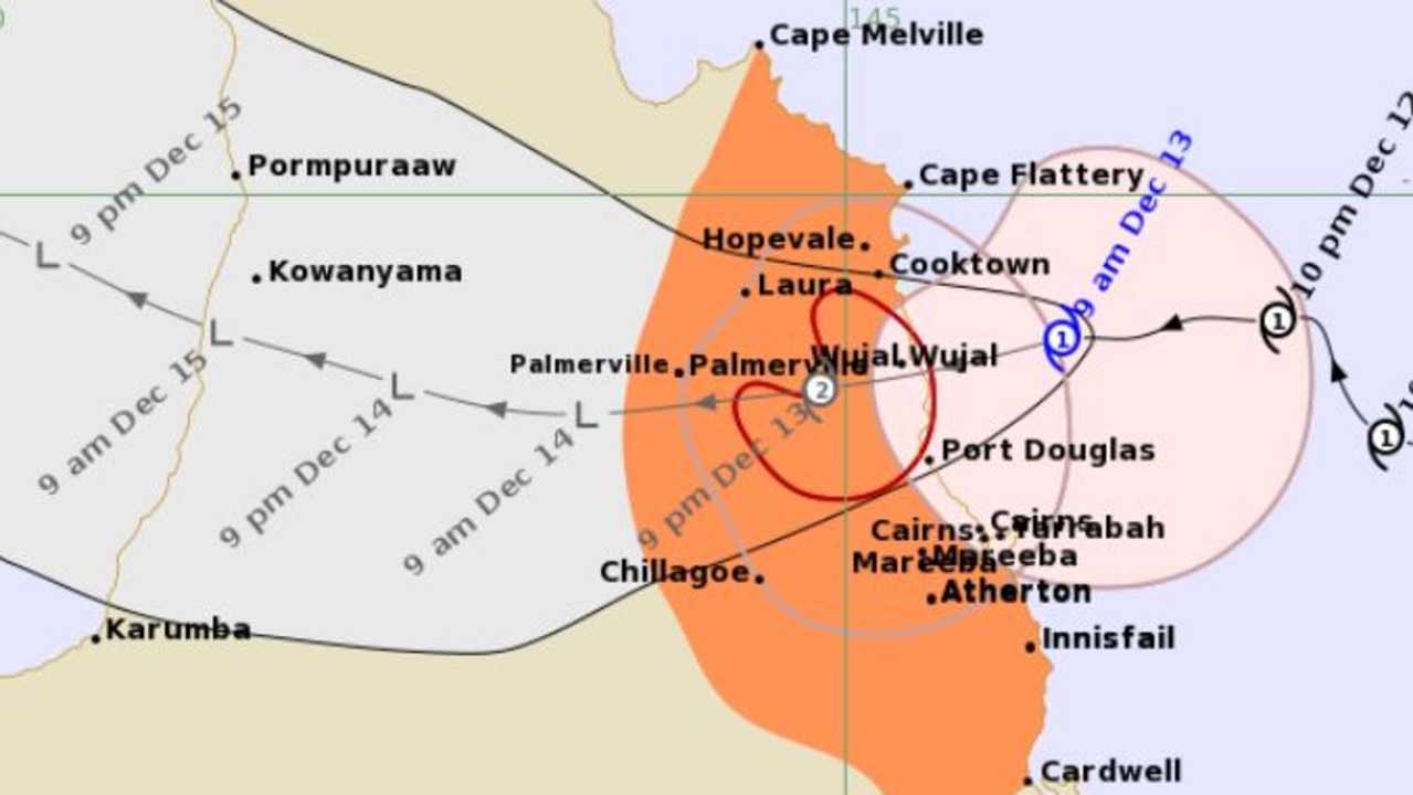
Tropical Cyclone Jasper set to make landfall on Wednesday
WHAT ARE THE CYCLONE CATEGORIES?
Category: 1 – Tropical Cyclone
Strongest gust: Less than 125 km/h. Gales
Typical effects: Minimal house damage. Damage to some crops, trees and caravans. Boats may drag moorings.
Category: 2 – Tropical Cyclone
Strongest gust: 126-164 km/h. Destructive winds
Typical effects: Minor house damage. Significant damage to signs, trees and caravans. Heavy damage to some crops. Risk of power failure. Small boats may break moorings.
Category: 3 – Severe Tropical Cyclone
Strongest gust: 165-224 km/h. Very destructive winds
Typical effects: Some roof and structural damage. Some caravans destroyed. Power failure likely.
Category: 4 – Severe Tropical Cyclone
Strongest gust: 225-279 km/h. Very destructive winds
Typical effects: Significant roofing and structural damage. Many caravans destroyed and blown away. Dangerous airborne debris. Widespread power failures.
Category: 5 – Severe Tropical Cyclone
Strongest gust: More than 280 km/h. Extremely destructive winds
.
Tropical Cyclone Jasper: Storm could be worse than Yasi

Ice ice baby: Spectacular images of unseasonal frost as Qld freezes
Queensland’s overnight temperatures will increase to double digits in the coming days, following the coldest start to winter in 16 years, bringing frost and ice to many regions. SEE THE PHOTOS

City’s coldest June start in 16 years, feels like MINUS 9.8C out west
Southeast Queensland is shivering through its coldest morning in more than 15 years but feels-like temperatures have dropped to insane levels in the southern inland.