
500mm on way: Four trapped, mudslides as big wet cuts highway, shuts airport
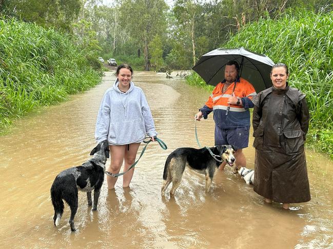
An emergency alert to watch and prepare for floodwaters was issued late on Monday night for residents living in the Mackay region amid rescues, mudslides and cut highways as the locale faces more torrential rain. NEW VIDEO, PICS
Mackay
Don't miss out on the headlines from Mackay. Followed categories will be added to My News.
- Cyclone outlook: Could hit ‘anywhere on Qld coast’
- ‘Stand together’: North Qlders selflessly care for flood-stranded
- Crushed cars, bogged boaties: Our SES heroes in action
An emergency alert to watch and prepare for floodwaters was issued late on Monday night for residents living in the Mackay region as wild weather smashes North Queensland.
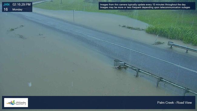
Mackay Regional Council has revealed the Pioneer River is predicted to peak at 7am on Tuesday, with impacts expected on drainage in Mackay CBD.
Areas east of Sydney St and north of Gordon St will most likely be affected.
Residents are being warned to avoid parking in this zone overnight or tomorrow morning.
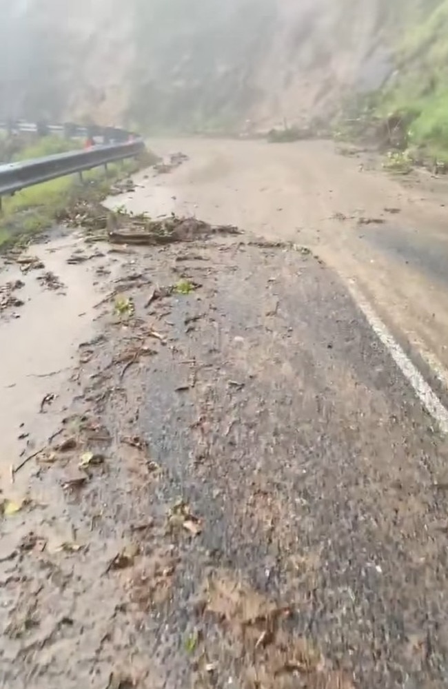
Earlier, the Bruce Highway was cut in several places, landslides were impacting a range leading to an isolated hilltop town, trains and flights were disrupted and dozens stranded.
A watch-and-act flood warning was issued for Cremorne in the Mackay region about 7.30pm on Monday, with residents urged to seek high ground away from the Pioneer River.
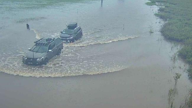
A motorist was rescued near Sugarloaf, in the Whitsunday region, after the vehicle they were in stalled in floodwaters.
It follows several other rescues over the weekend and dozens of cars seen entering floodwaters.
It comes as area controller for the Queensland State Emergency Services (QFES) John Forde said Monday afternoon that the rain would see water inundate some houses and lower lying areas.
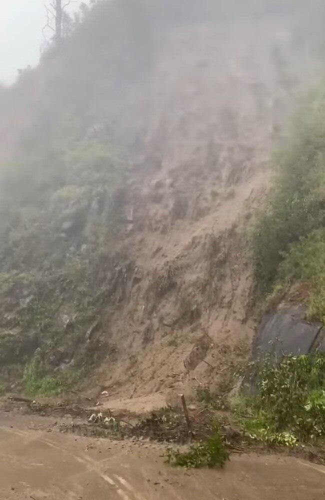
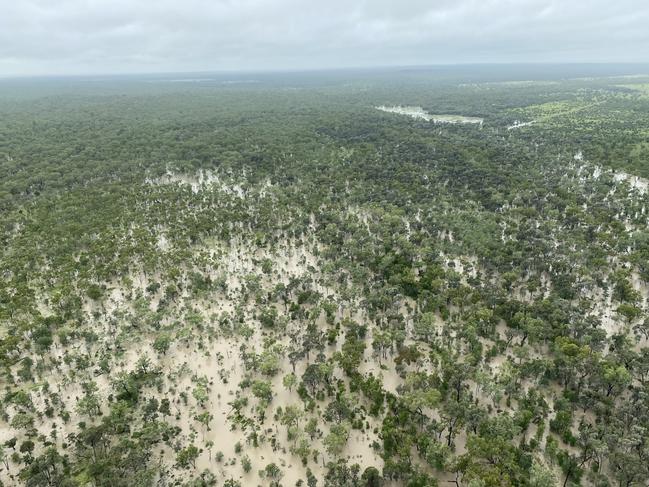
The heavy rain has also caused landslides. Video shows a muddy hillside washing onto the Eungella Range in the Pioneer Valley as the Bureau of Meteorology continues to roll out severe weather warnings.
A severe weather warning has been broadcast alerting the area from Ayr to south of Mackay that life-threatening and dangerous flash flooding may result from intense rainfall over the next few hours.
The Bureau of Meteorology has warned the expected rainfall may lead to major flooding including at Mackay, Proserpine, Bowen, Collinsville, Hamilton Island, Sarina, Ayr, Nebo, Eungella and Airlie Beach.
The bureau has also issued major flood warnings for both the Pioneer and Don Rivers with up to 500mm of rain expected in the next 24 hours around Mackay.
Flash flooding and heavy rain are expected over central and northern parts of the Central Coast and Whitsundays.
Six-hourly rainfall totals between 200 to 250mm are being tipped, with heavy isolated rainfall likely to cause further rises in the Pioneer River catchment.
The Don River at Bowen Pump Station could exceed the moderate flood level of 4m by Monday evening and the major flood level of 5.5m by Tuesday.
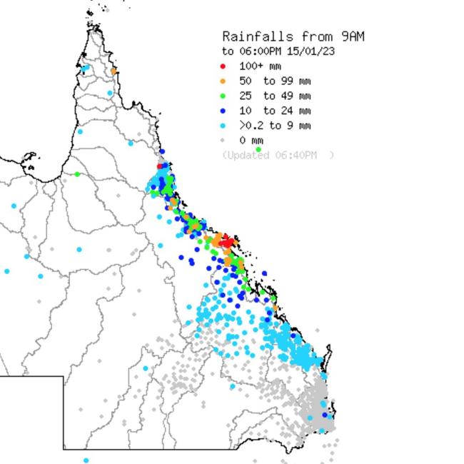
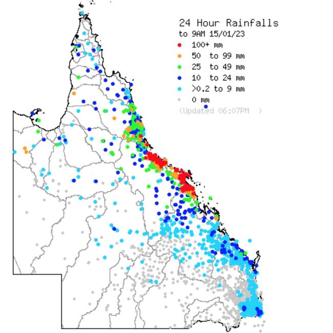
There has been 392mm at Jubilee Pocket in the 24 hours until 9am Monday, 372mm at Peter Faust Dam, 317mm at Proserpine Airport and 313mm at Preston and Bowen.
More than 200mm has fallen in some areas since 9am Monday with 241mm recorded at Eungella, 135mm at Clarke Range, 108mm at Peter Faust Dam, 161mm at Balaam Road near Bowen, 100mm at Dingo Beach and 107mm at Lower Gregory.
Weatherwatch meteorologist Anthony Cornelius gave a dire prediction for the week ahead on Monday afternoon, warning up to 600mm could fall in the next 36 hours
“It’s been a very nasty event so far with multiple days of falls of more than 200-300mm occurring in 24 hours, particularly for areas just north of Mackay and this has resulted in significant flooding,” Mr Cornelius posted on his official Facebook page.
“Unfortunately we still have at least another 24 hours (or more) of very heavy rain to come. C3 and EC are both really focusing on the areas just west and northwest of Mackay tonight and both models have more than 500-600mm occurring here in the next 36 hours (GFS has it a little further south).
“This is still linked to the same system - and meteorologically it’s quite incredible. It’s not often you see not one, not two, but three bands of convergence feed into a low pressure system like this. And all the airmasses feeding into the low are incredibly moisture laden.
“The convergence occurs when there’s air from opposing (or somewhat opposing) directions colliding into each other in an unstable airmass.
“This means there’s nowhere for the rain to go but up and generates further rain and storms.”
In its latest flood watch update issues about 1.15pm Monday, the Bureau said a weak tropical low near the Herbert and Lower Burdekin coast would drift southward along the east coast towards the Whitsunday Islands over the next day or two, enhancing rainfall.
“The tropical low may move east offshore, while the trough is likely to move northwards and become more monsoonal from Wednesday,” the Bureau said.
“Catchments across the flood watch area are wet to saturated from recent rainfall and are likely to respond relatively quickly to further rainfall.
“Areas of heavy to locally intense rainfall across the flood watch area are likely. Successive days of heavy rainfall are likely over some areas.
“Heavy rainfall is expected to continue over coastal areas between Townsville and Carmila, and potentially over adjacent inland areas.
“Minor to moderate flooding is possible across the flood watch catchments, with isolated major flooding possible. Heavy rainfall, possibly intense at times, may cause localised flooding, including flash flooding.”
Despite some concern the north Queensland weather event could develop into a tropical cyclone, the bureau said this was very unlikely. "There's less than a five per cent chance," forecaster Danny Teece-Johnson said.
"It is cyclone season and we're watching any lows very closely, but unless something drastic changes it's not going to happen."
Area controller for the Queensland State Emergency Services (QFES) Mr Forde said: “With a lot of water that’s already on the ground and the changing of the tides it also has an impact on the amount of water that’s around the place.”
Mr Forde said there has been an increase in request for assistance for the State Emergency Services (SES) with a lot of flooding and a request from QPS to attend a vehicle that was trapped in flood water.
“As a part of QFES we have weather planning levels which we have increased to level two and three across the regions,” Mr Forde said.
“What this means is that all of our crews are standing out ready to respond in certain areas.”
Mr Forde said the highest level is level three and level four.
“We are anticipating a bit more rain and weather to come through, but the main problems will normally occur around the hide tide marks,” Mr Forde said.
Flooding expected for Mirani, Mackay
Mackay council expects a major flood event to hit the Pioneer Valley town of Mirani early Tuesday morning.
The update was released on Monday afternoon at 4pm on the back of a new Bureau of Meteorology forecast of 400mm-500mm of rain for the Pioneer Valley across Monday night and into Tuesday morning.
Mackay Mayor Greg Williamson said the council’s models predicted a major flood event at Mirani at 2.45am and moderate flooding for urban Mackay at 7am.
Mr Williamson said the council did not expect the Pioneer River to break its banks at Mirani.
He also said the river would not break through the levee system in Mackay.
Mr Williamson said there would be flooding in lowland farming areas and areas north of Landsdowne Rd in Mackay.
He said the models did not predict inundation of houses.
The latest advice comes as frustrated authorities are pleading with drivers to stop trying their luck on flooded roads as a truck driver reportedly manoeuvred around warning signs only to become caught in floodwaters at Lethebrook forcing a swiftwater rescue mission overnight.
A truck is stuck in floodwaters outside Proserpine. The uninjured driver wasn’t carrying any freight, but decided to enter the flooded stretch of the Bruce Hwy early this morning. He phoned authorities to say there was water lapping at his handles @7NewsBrisbane@7NewsAustraliapic.twitter.com/mQvwb5eYDK
— Jordan Bissell (@Jordan_Bissell7) January 16, 2023
Emergency crews, including swiftwater teams, were called to the Bruce Highway about 10km south of Proserpine at 2.43am Monday where a B double was caught in floodwaters.
The driver did not require treatment from paramedics. (See more on this below)
TRANSPORT CANCELLED
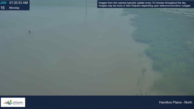
With roads closed at Hamilton Plains and Lethebrook, bus services to Proserpine and Whitsunday Coast Airport are cancelled while services between Shute Harbour and Braemer Rd in Mount Julian are still running.
Jetstar and Virgin have also cut flights into the region.
For more information, visit the airport’s website.
For a full list of road closures across Mackay, Isaac, Whitsunday and Central Highlands, click here.
Whitsunday Regional Council Mayor Julie Hall said the airport would reassess the situation later on Monday.
Mackay Regional Council Mayor Greg Williamson this morning told ABC despite the hype over the deluge, this was a “traditional wet season”.
“We’ve got to learn to live with the conditions it brings and that’s what we’ve been concentrating on over the weekend,” Mr Williamson said.

Precautionary floodgates have been erected in Mackay as North Queensland faces another 400mm of rain, and possible flash flooding.
“There’s still only a minor flood risk for the Pioneer River at the moment,” Mr Williamson said.
“We’ve got 40 river monitoring stations along the Pioneer River right now that monitors rainfall and river height.”
Isaac Regional Council Mayor Anne Baker said there was a lot of water around, particularly at Clermont, Dysart, Middlemount and the Isaac Coast.
Mrs Baker said crews were waiting for a break in the weather before they could complete patchwork on potholes and damaged roads.
Eungella left isolated
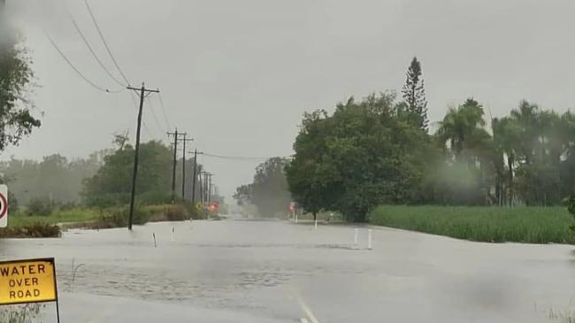
Mackay Regional Council has closed off the Mackay-Eungella road in both directions due to water over the road.
“The range will be closed from the bottom, just below Foodpac and at the top of the range, near the entrance to the Eungella Chalet,” the council stated.
The road was closed just before 1pm.
Rescue at Sugarloaf
QFES personnel rescued a motorist on Gregory Cannon Valley Rd after the vehicle stalled in flood waters on Monday afternoon.
A QFES crew then attended to a report of four people trapped in a car in rising floodwaters on Richardson Rd in nearby Sugarloaf.
A Swift Water Rescue team raced to the scene.
A QFES spokesman said the car had stalled mid-stream and remained stuck.
QFES personnel made contact with the vehicle’s occupants at 4.20pm.
A QFES spokesman said a rescue was not required.
Police also attended the scene.
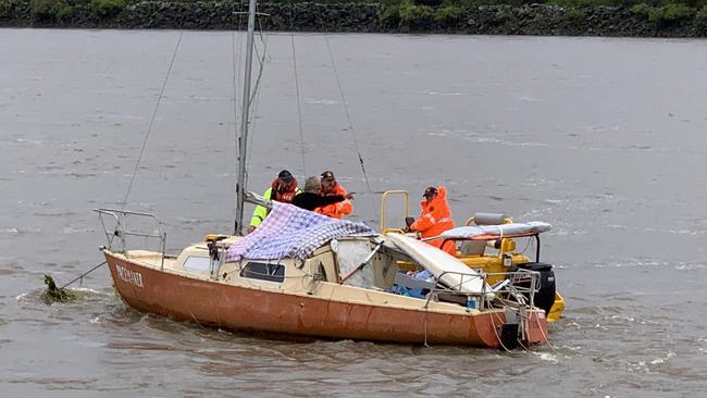
SES volunteers out in force
SES heroes are in the thick of the storm as Queensland faces its fifth day of punishing rainfall.
From Mackay to the Whitsundays, the volunteers have been called out to flood boat rescues, welfare checks on motorists and a range of storm protection jobs.
‘UNACCEPTABLE BEHAVIOUR’
Queensland Trucking Association CEO Gary Mahon has reacted with anger at the truck driver needing rescuing near Proserpine.
“That is just unacceptable behaviour,” he said.
“We just simply do not endorse any sort of that behaviour.”
He said truck drivers in general would disapprove of the driver’s action.
“I would be very confident truck drivers as a broad group would consider that very unacceptable,” he said.
Mr Mahon said the policy for truck drivers caught in flood events was to “sit tight”.
“Our employers do their best to support them while they are there but generally they have got to be reasonably self-reliant, same as anyone else caught in these waters”.
Mr Mahon said the rain event reiterated the need for greater investment in Queensland’s roads, both the Bruce Highway and inland freight corridor, to floodproof the delivery of goods.
A Queensland Police Service spokeswoman said 10 other vehicles also became stuck on higher ground between the two creeks in the same area south of Proserpine.
DAMS, CREEKS, RIVERS ON RISE
Kinchant Dam has started to release water overnight under its emergency management plan after it reached about 99 per cent capacity on Saturday night.
On Monday morning, the weather bureau issued a fresh severe weather warning for people in the Central Coast and Whitsundays and parts of Herbert and Lower Burdekin and Central Highlands and Coalfields Forecast Districts.
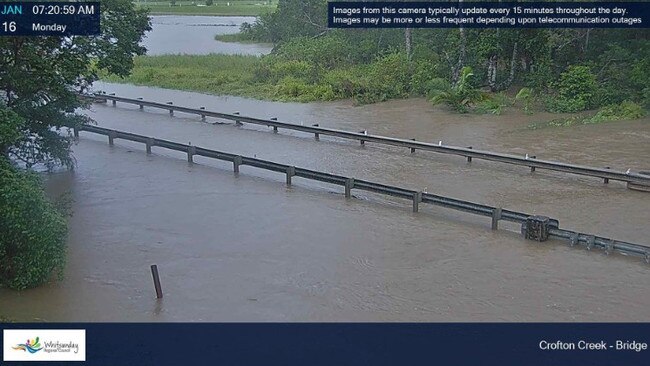
Parts of the Whitsundays are effectively cut off as heavy rain forced road closures on the Bruce Highway north and south of the region.
It is understood about 100 people camped out at Bowen’s PCYC after they were stranded because of road closures.
The bureau warned of six hourly rainfall totals of between 200 to 250mm and 24 hour totals of up to 400mm, north of Mackay.
The Coral Sea is also expected to brew a tropical low as large parts of Central and Northern Queensland stay on watch for “dangerous and life-threatening flash flooding”.
A weather bureau update on Sunday afternoon states a tropical low is anticipated to form on Monday in the eastern Coral Sea away from the Queensland coast with a five to 20 per cent chance it could become a tropical cyclone from Tuesday.
“If a tropical cyclone does form, it will move east and away from the Queensland coast,” the BOM states.
UP TO 400MM OF MORE RAIN COMING
The Bruce Highway was cut off on Sunday night at various locations including near Lascelles Avenue at Goorganga Plains, and north of Bowen.
On Monday morning, the weather bureau issued a fresh severe weather warning, saying heavy rainfall is expected between Ayr and Carmila, and potentially over the northeastern Central Highlands.
A slow-moving broad low pressure system is about the Herbert and Lower Burdekin coast and an area of strong convergence to its south over the Central Coast and Whitsundays. It is expected to remain into Monday night.
317MM RECORDED AT JUBILEE POCKET
“Heavy rainfall which may lead to flash flooding is forecast to continue during the day and tonight over southern parts of the Herbert and Lower Burdekin, and across the Central Coast and Whitsundays districts,’’ the warning said.
“Six-hourly rainfall totals between 100 to 180mm are likely with isolated 24-hourly totals up to 300mm.
“Over northeastern parts of the Central Highlands and Coalfields district, possible six-hourly rainfall totals between 80 to 120mm are possible with isolated 24-hourly totals up to 150mm.
“Six-hourly rainfall totals between 200 to 250mm with 24-hourly totals up to 400mm are possible, particularly about the coast and ranges north of Mackay.
Locations which may be affected include Mackay, Proserpine, Bowen, Collinsville, Hamilton Island and Ayr.
Significant rainfall observations since 9am AEST Sunday include: 317mm at Jubilee Pocket, 299mm at Peter Faust Dam, 252mm at Preston 237mm at Bowen and 230mm at Proserpine.
TRAVELLERS CAUGHT UNAWARES
Travellers including backpackers and families with children are scrambling to find accommodation as bookings are cancelled and highways are cut off.
The Prince of Wales Hotel in Proserpine is fully booked for the next few days and in Bowen, the Queens Beach Hotel has fielded inquiries from Townsville and Mackay residents who can’t get home including families needing to prepare for school resuming next week.
Whitsunday Sands Resort owners Jannet and John Courtney said families were separated from their children, pets, and workplaces with many sending emails in to their bosses.
Dozens of Whitsunday region residents have volunteered their homes as emergency shelter as others give towels or offer to do laundry for those taking refuge at Bowen’s PCYC.
Bowen resident Trudy Allen said the community’s generosity made her “very proud to be a Queenslander”.
“It doesn’t matter what town in Queensland, as soon as call goes out in this type of weather for assistance, out come the beautiful people,” Ms Allen posted in the Bowen Community Notice Board.
MINING TOWNS CUT OFF
Residents of Central Queensland’s isolated mining towns have expressed a mix of calm and trepidation as they tackle low medicine and food supplies.
The Queensland Traffic Map shows as of 4pm Sunday the road out of Dysart west to Clermont and east to Middlemount is cut-off, but the north and south Beef Road links to Moranbah and Dingo are still open.
Expected rainfall totals vary between 300mm to 400mm from Sunday through to Monday, particularly north of Mackay.
The bureau warns “locally intense rainfall” could lead to “dangerous and life-threatening flash flooding” over southeastern parts of the Herbert and Lower Burdekin, and the Central Coast and Whitsundays from later Sunday and through Monday.
RESIDENTS TRAPPED IN FLOODWATERS
The deluge comes after two teenagers plus a woman in her 20s were stuck in flood waters near Cedar Creek Rd at 3.15pm on Sunday north of Mackay.
All three were taken to Proserpine Hospital in stable conditions after Swift Water Rescue teams trekked through a private property to access the creek at Palm Grove.

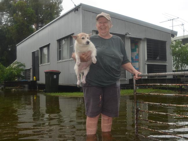
Further north near Townsville, pensioner Desley Page’s lawn has transformed into a lake.
The Cungulla resident said floodwaters had reached 2019 levels; backyard rain gauges in the town have recorded more than 400mm since Thursday.
Headed north again to Cairns, a police officer had to swim to safety after his 4WD was swept off a causeway and into floodwaters.
“Although widespread heavy rainfall has eased north of Ayr, isolated severe thunderstorms with locally heavy rainfall remains possible across the northeast tropics, including the Townsville area … locations which may be affected include Mackay, Proserpine, Bowen, Collinsville, Hamilton Island, Sarina, Ayr, Nebo, Eungella, Airlie Beach and Clare,” the Bureau of Meteorology has warned.
The Isaac region town of Clermont has been cut off since Friday as water covers the Gregory Highway at Pink Lily.
Peppercorn Motel manager Darryl Shaw said the roads in and out of the town were flooded with residents hunkering down to ride out the rain.
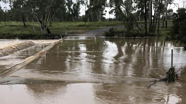
Hundreds have taken to Facebook to share photographs and videos of flooded roads including Pioneer Valley farmer Paul Fordyce who captured a photo of the overflowing Cattle Creek.
MORE HEAVY RAIN ON WAY
Significant rainfalls in the 24 hours to 9am Sunday included 271mm in upper Finch Hatton, 256mm at Finch Hatton, 234mm at Hamilton Island, 224mm at Rollingstone and 210mm at South Townsville.
At Eungella, a driver narrowly avoided serious injury after a tree fell onto her car along Dalrymple Rd on Saturday evening.
And while the majority of flooded roads have resulted from swelling creek-banks, residents in several regions are anticipating rising rivers with the BOM issuing various warnings.
Major flooding of the Pioneer River at Mirani is possible overnight Monday into Tuesday with “heavy to isolated intense rainfall forecast for remainder of Monday into Tuesday which is likely to cause further rises during the next few days.”
The Pioneer River could exceed 6m at Mirani by Monday afternoon, and may reach the major flood level of 9m “overnight Monday into Tuesday”, the BOM has warned.
In Mackay, the Pioneer River could reach the minor flood level of 6.3m “overnight Monday into Tuesday” and may reach 6.9m on Tuesday morning as it coincides with a high tide.
Mackay Regional Council has erected flood gates at three locations as a “precautionary measure” in case the Pioneer River spills into the city.
There is also a minor flood warning in play for the Connor-Isaac River Catchments with rainfall “likely to cause further areas of flooding” from Monday onwards “particularly across the Connors River catchment”.
VALLEY SWAMPED
Tourists hoping to see waterfalls at Finch Hatton Gorge in Eungella National Park are finding dead ends as Gorge Rd goes underwater and camping spots close their doors, including Wazza’s Platypus Bushcamp.
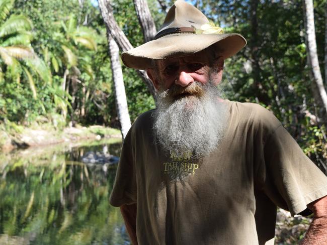
Warren ‘Wazza’ Swadling said the Pioneer Valley needed a good flush out not seen since Cyclone Debbie unleashed her downpours.
“It’s gonna look spectacular when it’s over,” Wazza said.
“The land needs it, it’s pretty dry out here.”
Wazza said no dead animals had washed up yet, reassuring that the platypuses the region is famous for knew what to do.
“I asked them all (the guests) to leave on Thursday … I’m sweet, I got beer in the fridge and tucker in the freezer,” he said.
REFUGES ESTABLISHED
The PCYC at Queens Rd in Bowen has been designated as a refuge from 6pm Sunday.
“Any stranded persons can park up for the night and use the facilities as required,” the Queensland Police Service posted to Facebook.
The Proserpine Entertainment Centre at 14 Main St has also opened for motorists to seek shelter as the Bruce Highway at Goorganga Plains strands motorists between Proserpine and Lethebrook.
Ms Hall said the Whitsunday Regional Council had activated the local disaster centre with more than 50 roads in the Whitsundays flood-affected.
“Don’t travel on the roads unless you really need to,” Ms Hall said.
CROCS FLUSHED OUT
The Proserpine River, well known for its crocodilian inhabitants, is reportedly washing out crocodiles towards beaches in the Whitsundays.
Ben White has captured a photograph of a crocodile he estimates to be about 3.5m long swimming off Wilson’s Beach near the mouth of the river.
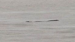
“I live at Wilson Beach, saw this easily 4m plus croc from my deck this afternoon so went down to the water to get a better look,” he said.
“At first I thought it was a log but once I saw the distinct head I knew it was a good size croc.”
WARNING ADVICE
Queensland Fire and Emergency Services advises that people should:
* Never drive, walk or ride through flood waters. If it‘s flooded, forget it.
* Keep clear of creeks and storm drains.
* For emergency assistance contact the SES on 132 500.
Flood warnings are also available by phoning the BOM on 1300 659 219.
ROAD CLOSURES
Drivers are advised to take extra care on the roads as large potholes claim victims with some having to call in tow trucks after their cars were significantly damaged.
Significant trouble spots include on the Bruce Highway between Kuttabul and Calen, north of Mackay, as well as on the Bruce between Sarina and St Lawrence, south of Mackay.
For a full list of road closures across Mackay, Isaac, Whitsunday and Central Highlands, click here.

Join the conversation

Two injured after car rolls on rural road
Two young men were lucky to escape serious injury after rolling their car on a rural Queensland road.
Read more
Mackay sale and auction results, week ending June 14
Moranbah proved to be a hot market last week with seven properties selling for a total value of $3.1 million. See the latest auction and sales results.
Read more