
Coastal areas to standby for cyclones as NQ prepares for 400mm drenching
Experts have warned of an increased risk of cyclones, for people who live “anywhere on the Queensland coast”, despite a predicted end to La Nina, with residents urged to have a cyclone plan at the ready.
QLD weather news
Don't miss out on the headlines from QLD weather news. Followed categories will be added to My News.
Queenslanders have been urged to have a cyclone plan at the ready, with the risk of increased cyclone and heavy rainfall to remain long after the expected cancellation of La Nina in February.
The Bureau of Meteorology predicts Coral Sea temperatures would remain well above average over the coming months, providing enough moisture to fuel cyclones should they develop anywhere along Queensland’s coastline.
1000+ photos: Qld’s most insane storm shots over the years
Widespread storms are forecast to impact all areas from Innisfail down to Proserpine and inland to Charters Towers over the weekend, with areas as south as Rockhampton possibly affected.
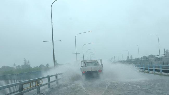
It comes after heavy falls smashed the majority of the north Queensland coast overnight, flooding Mackay.
Latest climate data shows La Nina will be officially cancelled in February, as the ENSO outlook returns to neutral.
However, the Southern Annular Mode is currently strongly positive, enhancing the chance of heavy rainfall for South East Queensland.
Meteorologist Felim Hanniffy said while La Nina was declining, cyclone risk would remain higher than usual.
“(There is) A lot of fuel there to fuel any tropical cyclone development,” Mr Hanniffy said.
“Even though we’ll have conditions returning to neutral to the later part of the summer months and into autumn, the sea temperatures lag behind and those above average temps usually mean increased cyclone activity.”
Disaster management and response expert Professor Iain MacKenzie said Queenslanders living along the southern coastline must also prepare for cyclone activity each year between November and May.
“If you live anywhere on the Queensland coast you should expect cyclonic conditions at some stage, they are moving further south,” Mr MacKenzie said.
“We shouldn’t be too concerned or excited when the conditions are for a certain number of cyclones because it only takes one to cause devastation, be prepared every season.
“Know what the cyclone ratings are and what your house can withstand, know where you’re going to go in the event of a cyclone, how you‘re going to get there and alert friends and family if you’re staying with them.”
This week, South East Queenslanders can expect possible showers on Monday and Tuesday and otherwise partly cloudy conditions and warm temperatures throughout the last of the school break.
Additional light showers are forecast on the Gold Coast over the weekend.
“There will be some showers in southern areas with the broad system coming down over Rockhampton and parts of the South East but those will be much lighter showers,” Mr Hanniffy said.
Meanwhile, north parts of Queensland remain on high alert as a slow moving trough continues to threaten widespread flash flooding.
Long winding storms are forecast to impact all areas from Innisfail down to Proserpine and inland to Charters Towers, lasting through early next week.
Mr Hanniffy said the trough was “only getting its act together now,” with some northern coastal areas expected to receive up to 400mm of rainfall.
Residents are reminded to check the Bureau’s extensive flood warning list and local council websites for information relevant to their area and to follow all directions from state, fire and police emergency services.


Ice ice baby: Spectacular images of unseasonal frost as Qld freezes
Queensland’s overnight temperatures will increase to double digits in the coming days, following the coldest start to winter in 16 years, bringing frost and ice to many regions. SEE THE PHOTOS

City’s coldest June start in 16 years, feels like MINUS 9.8C out west
Southeast Queensland is shivering through its coldest morning in more than 15 years but feels-like temperatures have dropped to insane levels in the southern inland.