
Damaging winds, icy conditions forecast for most of Tasmania
LIVE UPDATES: Thousands of homes in Hobart and Launceston may be without power overnight due to overhead line damage as a search and rescue mission continues on the South Coast. Full forecast | Latest warnings | Pictures + more >>
Tasmania
Don't miss out on the headlines from Tasmania. Followed categories will be added to My News.
- PHOTO FLASHBACK: Snowbart a winter wonderland in 2015
- Surf’s up: Tasmania’s points to fire up after the icy blast
This article is unlocked and free to read in the interest of public safety. Get full digital access to trusted news from the Mercury for just $1 for the first 28 days.
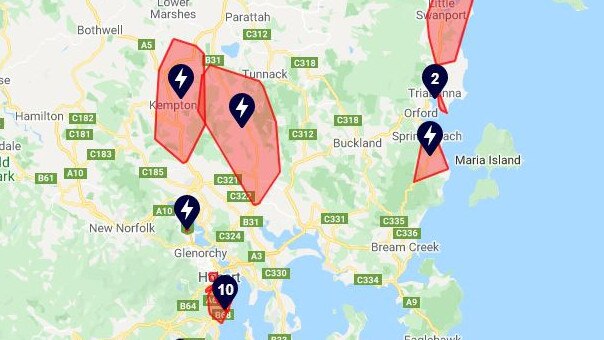
UPDATE 10PM: STILL thousands of homes remain without power, with 16 known outages, according to TasNetworks.
Almost 9000 homes continue without power, with TasNetworks narrowing the problem down to overhead line damage.
SEE THE MOST UP TO DATE INFORMATION FOR YOUR PROPERTY >>
Estimated restoration times for inner-city Hobart areas are midnight onwards, or to be confirmed.
UPDATE 9.20PM: A SEARCH and rescue operation is underway to save a man aboard a sinking vessel off the state’s South Coast.
Tasmania Police said officers were conducting a search for a vessel which issued a distress call about 8pm.
The vessel, with one man on board, was reported to have struck rocks south of Southport and was sinking when the distress call was made.
No injuries were reported from the incident.
Local vessels in the area have been contacted and are preparing to assist with the search, police said.
9PM: TASNETWORKS are reporting a slew of power outages in the South, on the East Coast and Launceston.
Currently there are 18 known outages affecting 13640 homes. Full list >>
- An outage at Sandy Bay is under investigation, TasNetworks said there will be an update after 9.30pm, with 2033 customers affected.
- An outage at Launceston, South Launceston, Trevallyn, West Launceston is under investigation, TasNetworks said there will be an update after 9.30pm, with 1697 customers affected.
- An outage at Hobart, Mount Stuart, North Hobart, West Hobart is under investigation, TasNetworks said there will be an update after 9.30pm, with 1523 customers affected.
- An outage at Battery Point, Sandy Bay is under investigation, TasNetworks said there will be an update after 9.30pm, with 1421 customers affected.
- An outage at Bonnet Hill, Dynnyrne, Kingston, Mount Nelson, Sandy Bay, Taroona, Tolmans Hill is under investigation, TasNetworks said there will be an update after 9.30pm, with 1030 customers affected.
- An outage at Mount Nelson, Sandy Bay, Taroona is under investigation, TasNetworks said there will be an update after 9.30pm, with 1007 customers affected.
- An outage at Mount Nelson, Taroona is under investigation, TasNetworks said there will be an update after 9.30pm, with 970 customers affected.
- An outage at Campania, Colebrook, Kempton, Rhyndaston, Richmond, Tunnack is under investigation, TasNetworks said there will be an update after 9.30pm, with 915 customers affected.
- An outage at Sandy Bay is under investigation, TasNetworks said there will be an update after 9.30pm, with 879 customers affected.
- An outage at Dynnyrne, Ridgeway, Sandy Bay, South Hobart is under investigation, TasNetworks said there will be an update after 8pm, with 711 customers affected.
- An outage at Sandy Bay, Taroona is under investigation, TasNetworks said there will be an update after 9.30pmm, with 704 customers affected.
- An outage at Mount Nelson, Sandy Bay is under investigation, TasNetworks said there will be an update after 9.30pm, with 352 customers affected.
- An outage at Orford, Rheban, Spring Beach is under investigation, TasNetworks said there will be an update after 9.30pm, with 243 customers affected.
- An outage at Hobart, West Hobart is under investigation, TasNetworks said there will be an update after 9.30pm, with 192 customers affected.
- An outage at Lenah Valley, New Town is under investigation, TasNetworks said there will be an update after 9.30pm, with 174 customers affected.
- An outage at Hobart is under investigation, TasNetworks said there will be an update after 9.30pm, with 163 customers affected.
- An outage at Glenorchy is under investigation, TasNetworks said there will be an update after 8.30pm, with 128 customers affected.
- An outage at Claremont is under investigation, TasNetworks said there will be an update after 9.30pm, with 115 customers affected.
- An outage at Triabunna is under investigation, TasNetworks said there will be an update after 9.30pm, with 81 customers affected.
- An outage at Snug is under investigation, TasNetworks said there will be an update after 9.30pm, with 61 customers affected.
- An outage at Cambridge is under investigation, TasNetworks said there will be an update after 9.30pm, with 28 customers affected.
- An outage at Triabunna is under investigation, TasNetworks said there will be an update after 9.30pm, with 10 customers affected.
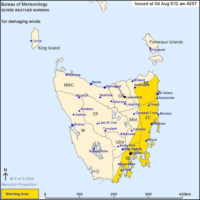
UPDATE: 5PM: THE Bureau of Meteorology has reinstated a severe weather warning for coastal areas along the Tasmania’s East Coast.
“A low pressure centre intensifies close to the east coast of Tasmania tonight, directing a strong south to southeasterly airstream over parts of the east and south of the state,” a statement from BOM read.
SEE THE FULL LIST OF ROAD CLOSURES >>
The warning area spans the entire east coast.
Damaging winds averaging 60 to 70 km/h with peak gusts of 90 to 100 km/h are expected to on parts of the east and southeast of Tasmania this evening.
Gusts of around 110 km/h are possible about the eastern coastal strip of Tasmania (including Swansea and Bicheno) in the early hours of Wednesday.
“Damaging winds are expected on the east coast of the state by around sunrise on Wednesday morning, then clear the east coast around midday,” the statement read.
Locations which may be affected include St Helens, Swansea, Bicheno, Orford, Hobart and Dover.
UPDATE, 4PM: SEVERAL of Tasmania's major highways have began to close as snow reaches areas such as Carlton Beach and Dodges Ferry.
For keen snowhunters Mt Wellington’s roads are closed from Bracklen Lane onwards due to the heavy falls and it is expected until at least 10am tomorrow.
The Mercury understands a trailer is currently blocking the Midland Highway and cars have been snowed in at Lake Dobson.
UPDATE, 3PM: SNOW is falling and is starting to set in high localities around Tasmania’s south east.
Reports are coming in of decent snowfalls in Fern Tree and Margate, but isolated reports suggest it is falling even lower.
Tasmania currently has seven outstanding weather warnings from the Bureau of Meteorology.
They are as follows:
- Marine Wind Warning for numerous East Coast waterways
- Flood Watch issued for numerous locations.
- Warning to Sheep Graziers for King Island, Furneaux Islands, Central North, North East, Midlands, East Coast, Upper Derwent Valley and South East forecast districts.
- Road Weather Alert for Tasmania for North West Coast, Central North, North East, Western, Central Plateau, Midlands, East Coast, Upper Derwent Valley and South East forecast districts. and,
- Bush Walkers Weather Alert for Western and Central Plateau forecast districts.
Sleet and some snow has started to fall in low-lying Hobart suburbs.
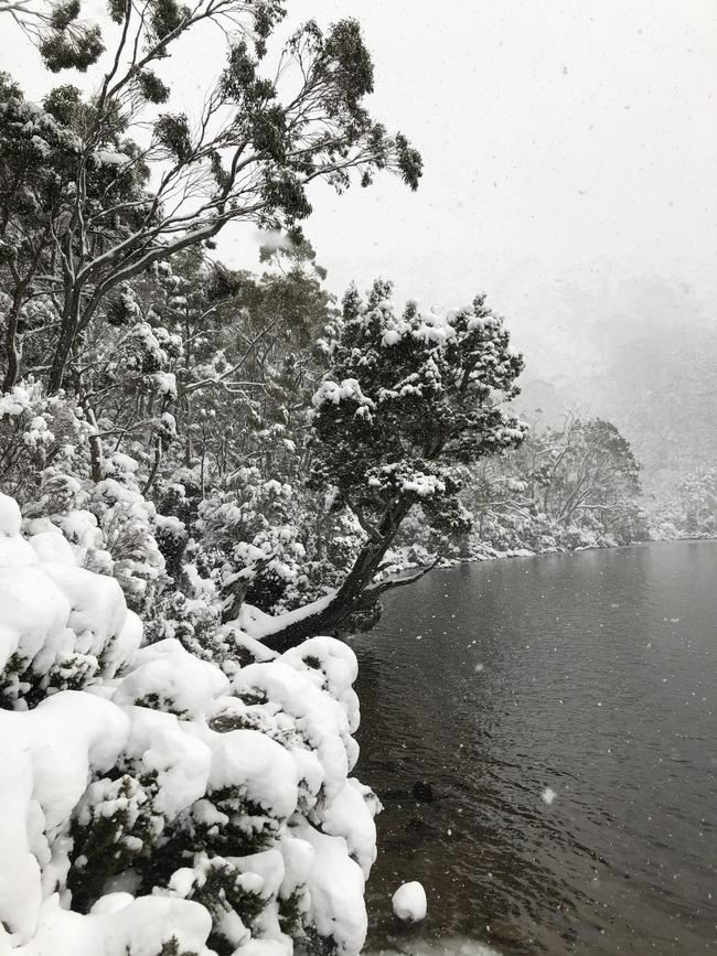
The Central Highlandsis also reporting thick snowfall.
There Tasmanian devils were snapped today enjoying the snow at Cradle Mountain.
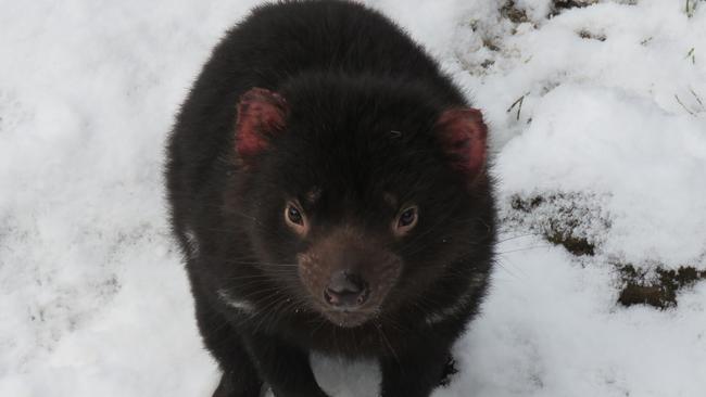
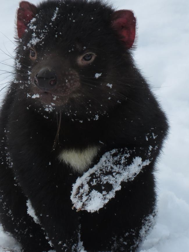
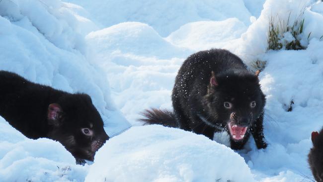
Do you have some snow pictures you’d like to share? Get in touch with us on Facebook!
UPDATE, 1.10PM:
Reports of snow continue to come in from around Tasmania, as the Bureau warns rainfall that may lead to flash flooding is likely for parts of the state.
Amazing look at the #snow that has blanketed Mount Field National Park. Snow to low levels again today. Find out what's happening in your local area: https://t.co/TTgUFxiROv ☃ï¸â„ï¸ #Tasmania #weather
— Bureau of Meteorology, Tasmania (@BOM_Tas) August 4, 2020
📽ï¸@islanddiaries_tasmania (Instagram). pic.twitter.com/cCPUEwuDma
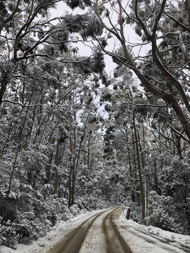
Snow has already fallen in many parts of the state including the north-west, the west and just east of Launceston.
Flood watch current
The Bureau of Meteorology has issued a flood watch, saying minor flooding is possible in the flood watch catchments from early Wednesday.
A complex low will cross Tasmania from Tuesday afternoon into Wednesday, bringing heavy showers to southern, eastern and north eastern Tasmania.
Most catchments in the flood watch area are relatively wet from seasonal rainfall.
Rainfall totals of 15-25 mm are forecast in southern areas for Tuesday night, with a further 30-50 mm forecast for Wednesday in south eastern and eastern coastal areas. Showers are expected to fall as heavy snow above 700 metres.
River rises are expected with forecast rain and minor flooding may develop from early Wednesday.
Catchments likely to be affected include:
- North Esk River
- South Esk River
- Macquarie River
- East Coastal Rivers (north of Bicheno)
- Huon River
- Channel Coastal Rivers (South East Cape to Gordon)
- Derwent River
- Jordan River
- Coal River
- East Coastal Rivers (south of Bicheno)
- South East
HOT OFFER: Get an unlimited digital subscription to The Mercury plus weekend papers home delivered from just $1 a week for 12 weeks
UPDATE 10.20AM:
The Bureau of Meteorology has issued a severe weather warning for the majority of the Tasmanian east coast.
“A low pressure centre develops close to the east coast of Tasmania today, directing a strong south to south-easterly airstream over parts of the east and south of the state,” a statement from forecasters said.
BOM is warning of damaging, strong southerly winds of up to 70km/h with gusts in excess of 110km/h.
Locations expected to be affected include St Helens, Swansea, Bicheno, Orford, Hobart and Dover.
The State Emergency Service advises that people should:
* Supervise children closely.
* Check that family and neighbours are aware of warnings.
* Manage pets and livestock.
* Secure outdoor items including furniture and play equipment.
* Be prepared in case of power outages and report any outages to TasNetworks on 132 004.
* Beware of damaged trees and power lines and take care when driving.
* Check www.ses.tas.gov.au for further advice.
* For emergency assistance contact the SES on 132500.
DOWNLOAD THE MERCURY APP TO GET WEATHER ALERTS ON YOUR PHONE
Snow has also been detected on the radar about 200 metres above sea level in the west, far south and northeast of the state.
I spy snow!
— Bureau of Meteorology, Tasmania (@BOM_Tas) August 4, 2020
Extensive snow on the satellite image about the west, far south and some about the northeast.
Looks to be as low as 200m.#weather #tasmania pic.twitter.com/jofU7OCNju
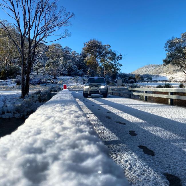
EARLIER: SNOW-covered roads across most of the state will make driving conditions dangerous over the next couple of days, with forecasters warning wild weather is setting in across the state.
Snow was tipped to fall to close to sea level overnight Monday, but much of Hobart missed out on the expected flurries.
Frost, further snow falls, rain and potential hail expected to continue into Wednesday.
The Bureau of Meteorology issued a road weather alert on Monday for parts of the Western, Upper Derwent Valley and South East forecast districts, and during Tuesday in parts of the North West Coast, Western, Central Plateau, Midlands, Upper Derwent Valley and South East forecast districts.

Sky Weather chief meteorologist Tom Saunders said Tasmania should expect snow at very low levels.
“The surface temperature predicted for the middle of the afternoon on Tuesday, so the warmest time of day, (we will see) temperatures below 10 degrees — even five degrees — in the middle of the afternoon for much of Tasmania,” Mr Saunders said.
“Obviously with it being so cold, we will see snow to low levels. On Monday evening and Tuesday morning that snow level in Tasmania will drop close to sea level.”
Sheep graziers are also warned that cold temperatures, showers and westerly winds are expected during Monday, with southerly winds on Tuesday with a risk of losses of lambs and sheep exposed to these conditions.
The BOM also issued a hazardous weather alert for bushwalkers in the Western and Central Plateau districts, with snow expected as low as 300 metres on Monday and 100 metres on Tuesday.
Meanwhile conditions are expected to be perfect for surfers chasing the big waves, with swells between three and five metres forecast on Wednesday morning for South East coastal waters between South East Cape and Tasman Island.
The swell is expected to be accompanied by a 25 to 35 knot south east winds turning southerly 20 to 30 knots over the morning.
Other trusted forecasters such as Seabreeze and Swellnet are also predicting monster waves for the South East.
Seabreeze expects waves to peak at 6.5m at 4am on Wednesday while Swellnet is forecasting “double overhead” waves for South Arm around midday.
Despite parts of Tasmania looking refreshingly green, the state has just experienced the driest July in more than 60 years, according to Bureau of Meteorology.
“It’s the driest July for Tasmania since 1957, parts of the North, East and West actually had the driest July on record,” said BOM climatologist Jonathan Pollock.
“We had persistent high pressure over South East Australia and that diverted cold fronts further south than usual and that really limited the amount of rainfall over the state.”

Election ‘25: Fishy final pitches as family get in on the act
From candidates dressing up as a tuna dancing on the side of the highway to the best democracy sausages and first-time voters with famous dads — today’s state election day has it all. Get the latest updates and results as they happen.

Voters favour Winter in hung parliament: YouGov poll
The final public poll of the Tasmanian election campaign released on Friday night points to another hung parliament, with unprecedented support for minor parties and independents.