‘Five-day flood’: Cyclone Alfred’s slow blow
This cyclone is erratic and the longer it stalks the coast, the more rain and flash-flooding it will dump on four million people in its firing line.
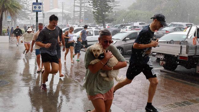
Cyclone Alfred’s “erratic” slow-down could trigger a five-day flooding disaster, as residents in 7000 northern NSW homes were ordered to flee with just hours’ notice on Thursday night and more than four million Queenslanders braced for its projected wrath.
The category 2 storm’s delayed arrival has turned two days of forecast rain into five, prompting NSW Premier Chris Minns to order emergency evacuations in parts of Fingal Head, Kyogle, Coraki and Lismore, just three years after 4000 of the town’s properties were ruined by devastating flooding.
Anthony Albanese’s widely tipped plan to call an election on Sunday or Monday for April 12 has been shaken by the looming cyclone, with prospects increasing that the government will be forced to deliver a March budget ahead of a May poll.
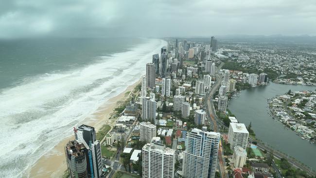
On the latest tracking data, released at 6am (AEDT) Friday, Cyclone Alfred was forecast to weaken into a category-1 system as it reached Moreton Island late on Friday or early Saturday.
The system was expected to remain a category-1 cyclone as it hits the main coastline near Caboolture, about 50km north of Brisbane after dawn.
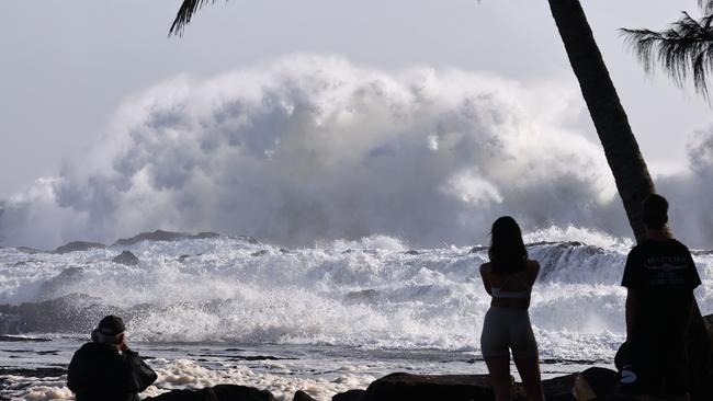
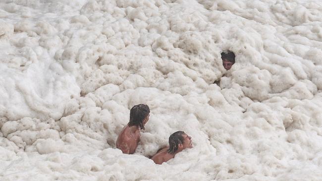
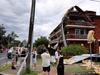
Heavy rain, huge surf, and strong winds were already smashing Moreton Bay on Brisbane’s coast, the southern Gold Coast and northern NSW on Thursday afternoon, felling trees, cutting power to more than 20,000 homes, and ripping sand off beaches.
NSW SES state duty commander Nicole Hogan warned Northern Rivers residents needed to leave before the heavy rain and fallen trees blocked escape roads and their homes could no longer withstand the rising floodwaters. “If you remain in the area, you may become trapped without power, water, and other essential services,” Assistant Commissioner Hogan said.
Weather experts are warning of “life-threatening” flash flooding even before Cyclone Alfred makes landfall, with the outer-reaches of the system predicted to inflict up to 400mm of daily rain.
The wild weather forced Qantas, Jetstar and Virgin to cancel all flights at the Brisbane airport, as airlines moved to shift planes out of Alfred’s way. Services won’t be rescheduled in the city until after the storm hits.
Gold Coast and Lismore airports have closed, and total flight cancellations in the region are in excess of 500, creating a logistical nightmare for airlines to get passengers where they need to go.
The Prime Minister on Thursday refused to rule out an April 12 election – which would need to be called by 6pm (AEDT) on Monday – with the decision on the poll date likely to be impacted by how much destruction the cyclone causes.
Mr Albanese, who is basing himself in Canberra to help co-ordinate the federal government’s response to the cyclone, said: “We have a budget that we’re prepared for. We have been focused on good governance and I must say that yesterday’s national accounts figures were very positive, with that 0.6 per cent growth in the December quarter,” the Prime Minister told Sky News.

At Lota on Brisbane’s southern bayside, 35-year-old office administrator Lara Keel was concerned the cyclone would intensify.
Ms Keel’s low-set home overlooking the mangroves was lapped by sea water at high tide and would be vulnerable to a storm surge.
“It’s definitely taking its … time, building up the anticipation,” she said of Alfred.
“I’m worried that it has stayed out there. I’m not a scientist but I’ve been told that it was going to create more rain.”
The cyclone’s track continued to defy prediction, doubling back early on Thursday before resuming a leisurely advance westward at barely 10km/h. The estimated time of impact has been pushed out from Thursday to Friday and now the weekend.
“What we’ve seen overnight, in terms of the erratic movement of the system, reiterates the fact this is an evolving situation,” said Matthew Collopy, a senior forecaster from the Bureau of Meteorology.
But there was always a possibility the cyclone could slow further, delaying its landfall. Mr Crisafulli warned the 4.5 million people in the firing line against complacency. “It’s the little decisions and little actions that you take today that can make a world of difference,” he said.
In Lismore, NSW Premier Chris Minns said: “The window for destruction in our community – heavy rains, winds, powerful surf – is longer than we would have otherwise.”
Conditions in Brisbane remained eerily still on Thursday, with flags barely fluttering in the steamy conditions. Scattered showers heralded the impending deluge.
The CBD was a ghost town, with most offices and many shops closed. Supermarket shelves were picked clean of bread, milk and bottled water; chemists sold out of first-aid products.
Newsagent Ann Lau, of Manly Harbour News, said customer reactions to the cyclone ranged from complacent to panicked.
Ms Lau arrived in Queensland only a few months ago from Melbourne. Her shop is situated metres from the harbour and she opted to stay open on Thursday while local supermarkets and other retail outlets closed their doors.
“Everyone’s waiting. We want it to come earlier and get it over and done with,” she said.
“I’ve never experienced a cyclone and I really don’t know what to expect. It all depends on how big the storm is.”
The message from Martin Jucker, of the University of NSW’s climate change research centre, was: don’t be fooled.
The cyclone was definitely coming.
“There’s no way Brisbane is going to get out of this, it’s going to be impacted. The forecasters are not getting it wrong,” said Dr Jucker, an expert in atmospheric dynamics.
“All the track predictions show it’s going to go over Brisbane, there’s going to be very strong winds, loads of rain, everything that’s been predicted.“
Dr Jucker explained that it was worth remembering that plots of the cyclone’s path simply showed where the centre was, and the effects would be felt much more widely, particularly south of the eye.
Atmospheric science expert Liz Ritchie-Tyo, of Monash University, agreed that “everyone just needs to hang tight”.
“Cyclones move about because of a few different factors but one of the biggest factors that pushes them in a particular direction is the large-scale steering flow from the atmosphere and for Alfred, it is being strongly steered by the winds from that very strong high pressure system that’s developed in the Tasman Sea,” Professor Ritchie-Tyo said.
“The winds to the north of that high are pushing it toward the west, which is why it’s moving towards the coast, and that’s not going to go away.”
Mr Collopy said the cyclone was packing sustained winds of 95km/h near the eye, gusting to 150km/h.
It would dump up to 800mm of rain on coastal areas between the Sunshine Coast and northern NSW, inducing life-threatening flooding.
If it crossed the coast on a king tide, a “significant” storm surge could add 1.5m to the high water at Redland Bay, south of Brisbane, and on the Gold Coast.
On the waterfront at Lota, friends Kye Larson and Thomas Jackson, both 21, had done all they could to prepare at home and were heading out to set a line of crab pots.
Additional reporting: Rhiannon Down, Elodie Jakes, Robyn Ironside
More Coverage


Add your comment to this story

Ley battles against the opposition leader curse
Of the seven politicians before Sussan Ley to take on the leadership of a party defeated at a recent election, only one – Anthony Albanese – has gone on to become prime minister.

PM backs away from joining France in recognising Palestine as state
Anthony Albanese suggested there first needed to be a ‘structure’ for a Palestinian state, saying he wouldn’t support any country with Hamas at the heart of it, while also slamming the ‘completely indefensible’ civilian death toll in Gaza.
To join the conversation, please log in. Don't have an account? Register
Join the conversation, you are commenting as Logout