
Victoria’s most shocking floods over the past few decades
Floods are devastating, traumatic and all too often deadly. Sadly, they are nothing new and have been wreaking havoc on our state for centuries.
The floods ravaging parts of northern and central Victoria are going to leave a clean-up that will take weeks. Families will be torn apart with the loss of loved ones, businesses will be literally washed away and homes will need to be rebuilt.
They are not the first floods to leave communities in ruins and they won’t be the last. Here we take a look at the floods that have left a trail of destruction through our state.
Yarra River Floods - 1934
The Yarra River in Victoria suffered mass flash flooding in 1934.
A powerful storm lashed Victoria in late November, buffeting the state with high winds and pounding rain, and leaving 36 people dead in the space of two days, according to the Australian Institute for Disaster Resilience.
Torrential rain began to fall in Central Victoria with 140mm falling in Melbourne within 48 hours. In South Gippsland, more than 350mm fell.

The beaches all around Port Phillip lost bathing boxes and jetties, and the wreckage of many vessels dashed in the storm littered the shore.
At Chelsea, rescuers — many of them volunteers — used boats to pluck more than 1500 women and children as 700 houses went under.
Hundreds were forced to flee houses in Abbotsford, Brighton and Gardenvale.
The overall damages from these floods was more than $250,000.
The Great Flood - 1956
The "Great Flood" of 1956 has been described as “the greatest catastrophe in the state’s history”, according to historian Ken Wells who was 21 when it hit.
The floods affected areas across Queensland, New South Wales and Victoria.
The disaster displaced thousands of people, wiped out crops, crippled local industries and left a damage bill in millions of dollars.
The flood occurred due to higher than average rainfalls in western Queensland and heavy rains in the preceding three months in the Murray-Darling Basin.
The flood was the culmination of a La Nina that began in 1954, bringing heavy rainfalls in Queensland, Victoria and NSW through until the first half of 1956, filling not only the Murray, but the Darling too.
The Murray would peak at 10.2m in Renmark and a staggering 12.3m at Morgan.
Some areas reportedly were flooded up to 100km from the normal flow of the river.
“Every few years there’d be smaller floods but never like the 1956 one,” resident Vonnie Fletcher said in 2016.
Shepparton, Murchison, Seymour Floods - 1974
In May 1974, flooding took over the towns of Shepparton, Murchison and Seymour.
Almost 200 homes and businesses were affected with over-floor flooding, while another 279 became isolated.

The Goulburn region suffered major flooding impact and nearly 200 buildings were damaged from floodwaters.
The floodwaters rose to 7.64m.
Both Sunday Creek and the Goulburn River flooded after heavy rain around the Seymour district.

Floods North-Eastern Victoria - 1993
Flash flooding occurred in October 1993 in North-Eastern Victoria, with heavy rainfall falling over a 24 hour period causing severe damage, according to the Australian Institute for Disaster Resilience.

Rainfall recorded during this period was 200mm, with 165mm recorded in Benalla.
Districts affected by the flood include Benalla, Euroa, Violet Town, Myrtleford.
The floodwater took a few days to reach Shepparton and Nathalia, due to the topography and the slow movement of the water.
The floodwaters covered 40,000 sq km, remaining for weeks and the recovery period for the areas took about 18 months.
8000 people were affected, with 1500 evacuated from their homes, and 3000 houses (and manu more businesses) damaged.
Other resources such as telephone services, power, sewage and water infrastructure, crops and livestock were all affected.
The costs to rebuild the affected areas such as local buildings, roads and recreation reserves was estimated between $3m and $5m, with businesses losing $10m and agricultural losses approximately at $30m.
The Insurance Council of Australia estimated the 1993 floods damage at $12m.
The Gippsland Floods - 2007
In late June of 2007, the Gippsland region was flooded after receiving record rainfall and causing widespread damage across the area.
These Gippsland floods were worse than those in the area 17 years and 19 years ago, according to the Victorian Emergency Services Commissioner Bruce Esplin.
One person was killed, four people were rescued by a boat, and more than 1000 emergency service workers were sent out to save people, shops and homes.

The Insurance Council of Australia estimated the 2007 damage at $15m.
“A lot of the locals have said they have never seen it like this. It's definitely been a wake-up,” Mr Michael McOrist said at the time.
Victorian Floods - 2010
Victoria suffered another flooding crisis across the state in 2010.
The floods were followed by heavy rain in early September and caused damage and destruction to approximately 250 homes, with hundreds of evacuations and millions of dollars damage.

Weather warnings were issued for Victoria in September and rain began to fall throughout the week.
Victoria had been in severe drought since the late 1990s, and had been progressively receiving excessive rainfall since the late 2000s.
By mid-2010, Victoria received some of its highest rainfall recorded in a long time.
No deaths were recorded throughout the 2010 Victorian Floods.
Victorian Floods - 2011
In 2011, floods pummeled Victoria throughout the months of January, August and September.
Many areas were already affected by the floods the year before, but the 2011 floods did far more damage to the state.
Thousands of evacuations were called for by the State Emergency Service, more than 17,000 people lost electricity supply and 6016 sheep died.

The Victorian Employers Chamber of Commerce and Victorian Farmers Union estimated damages were over millions of dollars.
Two deaths were recorded from these floods, one involving a boy who went missing in a flooded billabong off the Goulburn River and a man who died after falling off the roof of his Glen Waverley home.

Victorian Floods - 2012
Severe weather warnings for flash flooding were issued for the majority of Victoria in 2012.
The State Emergency Service responded to 650 calls for emergency assistance across Victoria, according to the Australian Institute for Disaster Resilience.
There was flash flooding and minor building damage across the state after there were rainfalls between 50mm and 100mm.

In towns such as Seymour, there was 120mm of rain causing flash flooding and road closures to the area.
Businesses in the main street of Chiltern were flooded after 94mm of rainfall and Broken Weir near Benalla recorded the highest rainfall with 167mm.
Castlemaine received 50mm of rain within an hour and a half, with 11 homes and six shops flooded as a result.
The floods also continued over into the next month. No deaths were recorded.
Gippsland Floods - 2021
Victoria suffered from a flash flooding disaster in 2021, particularly affecting the Latrobe Valley region where two people were killed and thousands of Traralgon locals were left without power.
Evacuation orders were issued in the Traralgon Creek area and more than 64,000 households were without power.
A relief centre opened at the Traralgon Basketball Stadium on Garibaldi St Traralgon in order for people to stay safe.

Rainfall of 5mm to 15mm was received for the Traralgon Creek catchment during the flooding incident, and renewed rises occurred in the upper catchment of the creek.
A Victoria State Emergency Service spokesperson said there were more than 8100 requests for assistance.
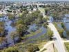
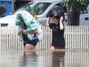
Victorian Floods - 2022
Sirens blared across Victorian towns in October 2022 as residents were ordered to evacuate their homes due to flashing flooding occurring across the state.
Two people have so far been killed, and thousands more homes destroyed.
Heavy rains caused rivers to flood and despite sandbagging efforts, water had begun to seep into homes, businesses and filling up roads.
The floods have affected towns across the state, including Echuca, Shepparton, Rochester, Maribyrnong, Benalla, Wedderburn, Seymour, Murchison and Carisbook.

The riverside towns hit by Victoria’s worst flooding in decades face a potential second wave of devastation from a downpour that will lash the state for the rest of this week.
Greater Shepparton mayor Shane Sali said up to 4000 homes were set to be impacted by the floods, with those living southwest of the city centre and in low-lying areas near the Goulburn River were most at risk.
Across the state, at least 1800 Victorians were left without power as substations were suspended due to safety concerns.
The government also announced up to $15m to help families with housing, health and wellbeing, and financial and legal counselling.
“This is going to be with us for an extended period.” Premier Daniel Andrews said.

Stay safe during these events by never entering or driving through floodwater. Call 132 500 for emergency assistance from VICSES.
Stay informed, monitor weather warnings and forecasts at the Bureau of Meteorology website, and warnings through the VicEmergency app, website and hotline (1800 226 226).

Meet your 2026 Ballarat and Daylesford school captains
