
NSW floods: Sydney suburbs subject to evacuation warnings and orders
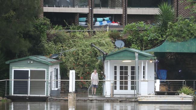
Aerial photos have shown the shocking extent to which a southwest Sydney town has been inundated with floodwaters, as the SES issues new evacuation orders for other towns across the region.
Local
Don't miss out on the headlines from Local. Followed categories will be added to My News.
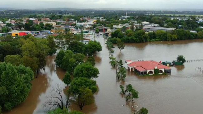
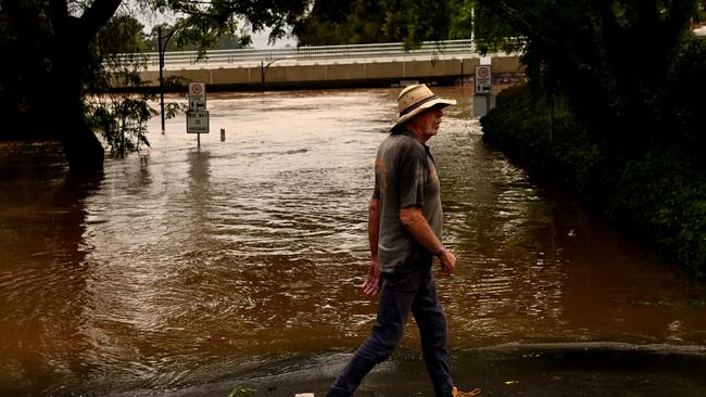
Shocking aerial photos show a southwest Sydney town underwater as floods completely inundate their region.
The drone images show Camden in Sydney’s southwest flooded as the entire greater Sydney region braces for an impending east coast low this morning.
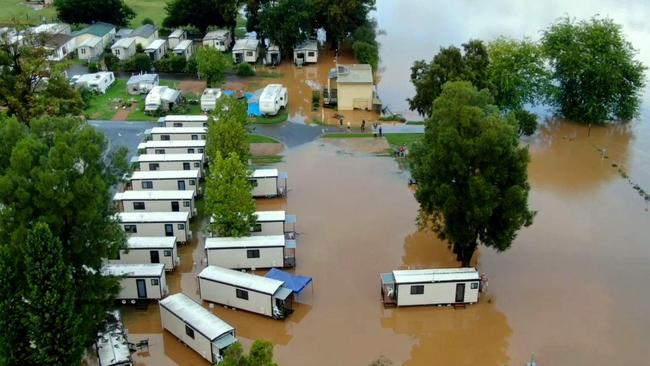
An evacuation order remains in place for parts of Camden at Sheathers Ln, Kirkham Ln, Menangle Rd near Racecourse Rd may be isolated, Poplar Caravan Park, Cawder Rd between Barsden St and Murray St and Peter Ave between Onslow Ave and Belgenny Ave.
“Once floodwater reaches 8.5 metres at the Camden Weir, the area will be isolated,” the order read.
“If you remain in the area you may be trapped without power, water and other essential services and it may be too dangerous to rescue you.”
Stonequarry Creek Bridge at Picton was assessed by council engineers on Thursday morning and has now reopened.

However, an evacuation warning remains in place for the Picton CBD and residents are urged to be prepared to leave if needed.
To the north, a new evacuation order has been issued for all properties along Bents Basin Rd at Wallacia.
Residents have been directed by the SES to leave the area by 11.30am with people who remain running the risk of being trapped.
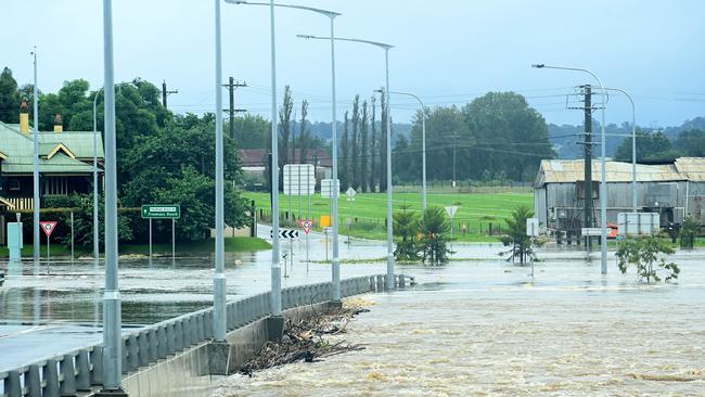
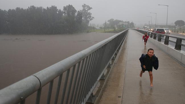
More than half a million people are now subject to flood evacuation orders, with NSW Premier imploring residents to leave when they are asked before it is too late.
At a press conference this morning, Premier Dominic Perrottet expressed his sympathy for families traumatised by fleeing their homes in the past 24 hours as rain continued to pelt down.
“We are with you side-by-side through this difficult and challenging time,” the premier said.
“We have currently half a million people across our state who are subject to either one of those warnings or one of those orders.”

The premier did not mince his words in urging people to leave before it was too late, with an east coast low expected to batter greater Sydney in the coming hours.

“If you are subject to one of those evacuation warnings, please get ready,” Premier Perrottet said.
“If you are subject to one of those evacuation orders, please get out – those instructions are not there for the sake of it, they are there to keep you and your family safe.”
Emergency services minister Steph Cooke echoed the premier’s sentiments, saying she was particularly worried about communities in southwest Sydney, greater Sydney, the Central Coast and the Hunter.
“I know you’re tired, it has been a long night, many of you have had to evacuate from your homes over this time,” Ms Cooke said.
“It has been a sleepless night for many people – we know that you are weary, but we need
you to stay with us, and we need you to keep listening out to the warnings, to the information that our emergency services organisations are putting out.”
Ms Cooke said there are currently 76 evacuation orders in place covering 200,000 people, and 18 evacuation warnings nearly 300,000 people who must be prepared to leave imminently.
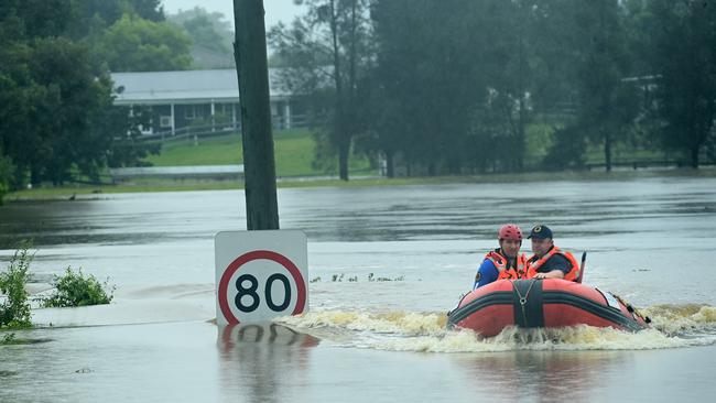
More than 100 volunteer surf life savers have put themselves on standby to relieve others who have been assisting in the NSW floods across the state as the weather situation continues to develop
On Thursday volunteers who had been deployed to the Shoalhaven area to assist emergency services were being deployed to the worsening situation in Sydney’s west.
Four IRB crews of 10 people were heading back towards Sydney to help emergency services in any way needed, including assisting getting the eldery and sick the help to safety and medical attention.
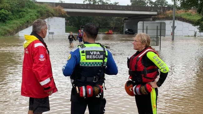
Surf Life Saving NSW said 20 IRBs and around 80 volunteers are currently working in various flood zones, including the Hawkesbury, Liverpool and George’s River.
Surf life savers from Central Coast clubs like Umina and North Entrance deployed to the Shoalhaven are the ones heading to western Sydney.
“Crews from down south are on their way back to western Sydney to relieve crews who have been out since yesterday,’’ a Surf Life Saving NSW spokesperson said.
“IRBs are rescuing people, helping with evacuations and helping emergency services in any way they are needed.’’
WESTERN SYDNEY:
A flood rescue operation to reach six children and four alpacas trapped by rising flood waters is taking place in western Sydney.
SES crews are undertaking the rescue at a property at Shane Park Rd, Shanes Park.
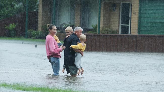
It comes as hundreds of western Sydney families were evacuated due to flooding as the water levels of Hawkesbury and Nepean rivers continue to rise.
It comes as hundreds of western Sydney families have been evacuated due to flooding as the Hawkesbury and Nepean rivers continue to cause concern.
Properties in parts of Riverstone, Cattai, Windsor, Yarramundi, Londonderry, Vineyard, North Richmond, Mulgrave, Shanes Park and South Maroota have been ordered to evacuate.
On high alert are residents in parts of Penrith, Jamisontown, Mulgoa, Pitt Town and Lower Portland with flood evacuation warnings in place. This means residents should be preparing to evacuate if conditions worsen.
Melissa McIntosh, MP for Lindsay, has urged locals to “look out for each other”, as areas of Londonderry and Agnes Banks receive evacuation orders.
In a Facebook post this morning, Ms McIntosh said, “When we have the best community spirit in the country, we can get through anything together.”
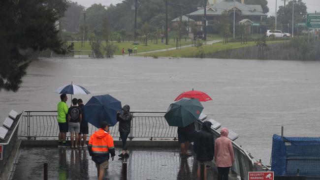
Situated in front of Tench Reserve, a park that has been completely flooded by water from the Nepean River, Ms McIntosh noted that while the water levels had dropped slightly, it is vital locals get their evacuation plans in order.
“Make sure you have your evacuation plans in place and are activating those now. We know there will be a number of potential evacuations going to be happening, depending on what’s happening with the floods across our community and also here along the Nepean River.”
SOUTHWEST SYDNEY: “LEAVE NOW”
Multiple suburbs in the Liverpool area are being told to evacuate their homes immediately as the Georges River swells following heavy rainfall overnight.
Residents in Moorebank, Chipping Norton, Warwick Farm, and Holsworthy have all been given notice to leave.

The SES said low-lying suburbs near the river are at real risk and anyone who cannot stay with friends or family or in alternate accommodation can join the evacuation centre at the Cabra-Vale Diggers Club at 1 Bartley St Canley Vale.
The biggest concern is the rise of the river again in the afternoon as the rain continues throughout the day, including predicted thunderstorms and flash flooding.
The SES advises to take pets, essential items, insurance documents, warm clothes, medicines and valuables with you, and leave everything else behind.

CENTRAL COAST: MORE THAN 1000 DOORKNOCKS
NSW SES Wyong Unit Commander Matt Le Clerq said local SES crews, with support from Surf Life Saving clubs, the Rural Fire Service and Volunteer Rescue Association, had knocked on more than 1000 homes to check on residents, advise of the evacuation orders and help with their preparations.
“By this afternoon, we had door knocked all of the houses from historical data in low lying areas,” Mr Le Clerq told the Express.
“Around 20-30 people have self evacuated (to The Entrance Diggers) which isn’t a significant number but we know that a lot of people have gone to their families and friends.”
Mr Le Clerq said the Lake is currently sitting just over one metre.
“We are just past the minor flood level,” he said. “I know the BOM has advised it could reach 1.6m but we’re not sure it will get there. Currently the east coast low is tracking north of us but that’s not to say it’s not going to come back.”
Mr Le Clerq praised the community for their help in terms of sandbagging. He said between the Gosford and Wyong SES units, more than 600 tonnes of sand had been bagged.
“That’s around 20,000 bags,” he said. “The community response has been amazing and showed that the community is more aware of the impacts of floods having been through them in 2021 and 2020. They have been preparing earlier.”

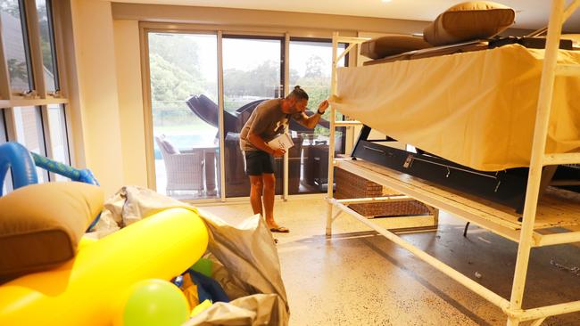
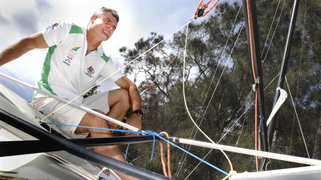
Multiple Olympic medallist Darren Bundock and his family were on Thursday preparing to evacuate their lakeside house at Berkeley Vale close to a year to the day it also flooded.
Budock received a text message to alert them there was an evacuation order for the area.
He and his partner and son were moving as much furniture and boxes upstairs as they could.
“They are saying it could rise 15cm to 1.6m,” said the Sydney and Beijing Olympic sailing silver medallist who is now an Australian sailing coach.
“Last year in March it got to 1.4m.
“This is now the third year in a row we have had flooding.’’
More than 100 volunteer surf life savers have put themselves on standby to relieve others who have been assisting in the NSW floods across the state as the weather situation continues to develop
On Thursday volunteers who had been deployed to the Shoalhaven area to assist emergency services were being deployed to the worsening situation in Sydney’s west.
Four IRB crews of 10 people were heading back towards Sydney to help emergency services in any way needed, including assisting getting the eldery and sick the help to safety and medical attention.
Surf Life Saving NSW said 20 IRB’s and around 80 volunteers are currently working in various flood zones, including the Hawkesbury, Liverpool and George’s River.
HUNTER: HEAVY RAIN STARTING TO IMPACT REGION
Wind squalls and heavy rain began lashing parts of Newcastle and Port Stephens about 10am as the deep low heads south-west.
A king tide, which peaked at Newcastle about 10am, has also caused some issues along the coast from Seal Rocks to south of Lake Macquarie.
Thursday’s rain event has stretched inland to Cessnock and the lower Barrington Tops.
There is a minor flooding warning for the Wollombi Brook and Lower Hunter River as well as parts of Lake Macquarie.
INNER SYDNEY: ALERT FOR INJURED WILDLIFE
A wet and injured baby brushtail possum has been rescued from a front porch at Mascot with WIRES expecting more waterlogged wildlife to seek shelter in homes.
WIRES spokesman John Grant said the juvenile possum, nicknamed Bolt, was expected to make full recovery and be released back into the wild soon.
“He’s since been dried off, warmed up and eating well in the expert hands of WIRES carer Kirsten who is treating an infected wound on his back,” Mr Grant said.
“He will be returned home as soon as he gets the all clear from the vet.”

Mr Grant said even parts of Sydney which were not experiencing flooding but still receiving heavy rainfall could see an increase in wildlife around the home as their usual tree hollow hiding spots were filled with water.
Don’t touch the animal or bird as they will often depart on their own after taking a rest but if you think the critter is injured, call WIRES for advice.
“Just like us, our native animals also seek shelter in continuous rain events and can suffer stress and shock when their regular habitat is inundated,” Mr Grant said.

“They will often choose a dry spot on verandahs, porches, garages, under eaves and in garden sheds. It is best to just leave them undisturbed and they will depart of their own accord when the weather clears.
“Along with marsupials, birds are also badly affected by the rains as they can become waterlogged and unable to fly. Young sea turtles and marine birds are often swept off course and found exhausted on beaches or upstream on the banks of tidal waterways that flow into the ocean.

“Native animals are also more likely to be crossing roads at night as they search for shelter and food so please be careful when driving especially near parkland.”
If you see a native animal in distress please call WIRES on 1300 094 737 or visit www.wires.org.au
Residents in Sydney’s eastern suburbs have been warned to avoid the coastal walk between Bondi and Bronte, which Waverley Council closed about 1pm today.
The sections closed are Notts Avenue, Tamarama, Bondi Beach and Marks Park, a spokesperson said, adding they will re-open it when it is safe.
Photos of the coastal walk showed an aggressive surf overflowing onto the footpath.
Waverley Council’s Manager of Lifeguard Services, Matt du Plessis, said surf and swell conditions remained hazardous for coastal activities including swimming, surfing and rock fishing.
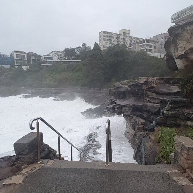
“I implore people to observe these warnings and always follow instructions from our Lifeguards,” Mr du Plessis said.
“As a general precaution, swimming at ocean beaches should be avoided for up to one day after heavy rainfall or for as long as stormwater is present.
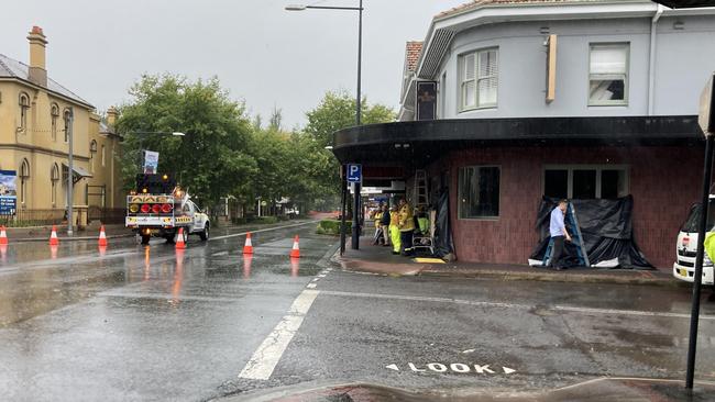
More rain hit the inner west last night and across the morning as the SES closed roads in Marrickville due to localised flooding and the Cooks River exceeding minor flood levels around Tempe.
The SES put out a message last night that the Bureau of Meteorology had issued an ‘initial minor flood warning for the Cooks River’ for Thursday morning.
At Tempe Bridge, the Cooks River was likely to exceed minor flood level (1.3m) and peak at 1.5m on high tide.

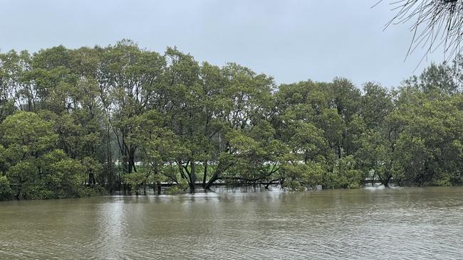
The trunks of shoreline trees hugging the river were submerged today and patches of the surrounding areas under water, but although the water level was high, the river wasn’t experiencing the flooding seen across other spots across the state, most notably the Hawkes River.
In Marrickville, flood-prone Carrington Rd was closed by SES staff this morning due to localised flooding on the intersection with Myrtle St and Richardsons Cres.
Inner West Council and SES staff continue to work tirelessly to shore up flood protection across the area and respond to localised flooding.
THE HILLS EVACUATES
Residents evacuating from the floods can relocate to Castle Hill RSL, which is now operating as an evacuation centre.
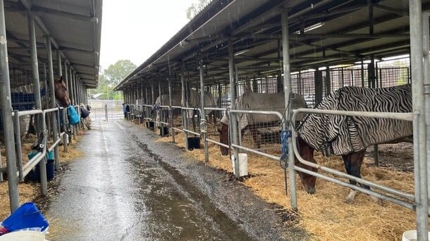
Due to the flood risk, Castle Hill Showground was opened to evacuated horses, livestock and domestic animals on Tuesday.
This morning, a Hills Shire Council spokeswoman confirmed Castle Hill Showground still has space for evacuated horses.
“We are housing 44 horses right now and currently have capacity for an additional 25 horses,” she stated.

The Hills Shire Council has closed several roads in response to the rain pelting down on this region.
These roads include: Blue Gum Rd in Annangrove, McClymonts Rd in Maraylya, Cattai Ridge Rd at Maraylya and Glenorie, 990-1027 and 2255-2275 River Rd in Leets Vale, Terry Rd at the intersection of Hedgewood Dr in Box Hill, and 313-337 Pitt Town Rd in Maraylya.
Boundary Rd between Old Pitt Town Rd and Maguires Rd in Gables has been reopened.
In a Facebook post, Mayor Peter Gangemi encouraged residents in flood prone Hills suburbs to be prepared.
“I encourage residents, especially those located in our northern regions … to begin actioning their flood plans, including moving machinery to higher ground and relocating livestock,” Mayor Gangemi wrote.
SOUTH COAST AND ILLAWARRA
The Illawarra and South Coast are bracing for record-breaking storms that have left large swathes of the state underwater, only a year after wild weather wrecked local homes and businesses.
A weather system currently travelling down the coast was forecast by BOM to reach parts of the Illawarra and South Coast regions on Tuesday night, before becoming more severe on Wednesday.
Parts of the Illawarra have continued to cop heavy downpours with Albion Park being hit with more than 100mm of rain to 9am on Wednesday.
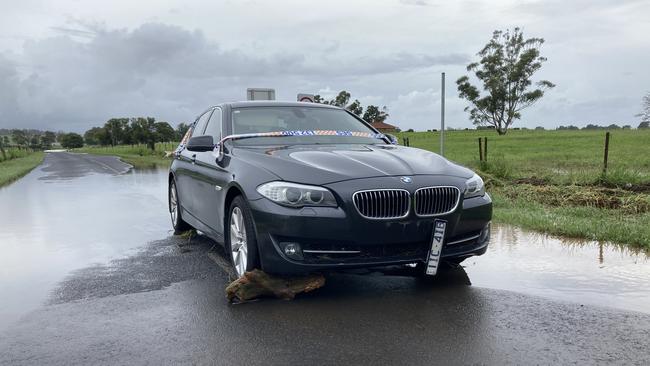
The wild weather has made for dangerous conditions on the roads with a number of routes closed as of 6pm Wednesday.
Trains between Waterfall and Bomaderry have also been halted due to water over the tracks. Buses are operating between Waterfall and Thirroul, and Wollongong and Kiama.
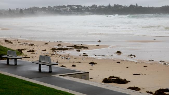
On the south coast, severe weather conditions continued for a second day on Thursday, as residents across the south coast wait to find out if devastating flood events felt elsewhere in the state will be repeated.
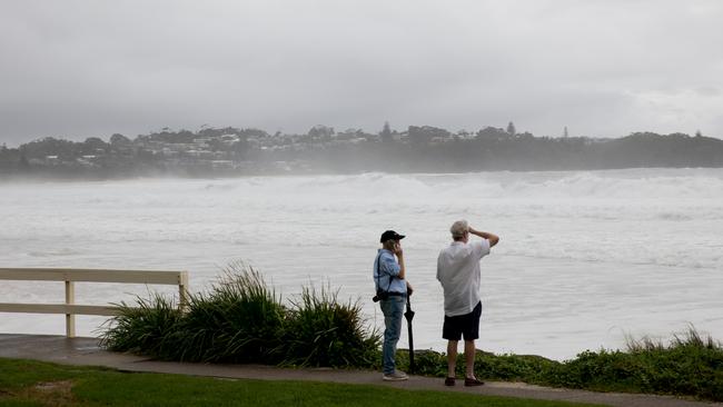
In the popular beach town of Mollymook, roads, paths, and beaches were mostly abandoned
The usually popular restaurants and businesses nearby to Mollymook beach were either shut completely, or mostly empty.
Still, the mid-tide waves that were regularly smashing against the grass hill at the very end of the beach weren’t enough to deter everyone.
Onlookers snapped photos and videos of the rough surf, while one family braved the dangerous beach.
Full list of road closures here.
PORT MACQUARIE AND THE MID-NORTH COAST
The mid-north coast has mostly escaped unscathed as horrific weather conditions pummelled the coast to the north and greater Sydney to the south.
Minor flooding is possible at Settlement Point on Friday with the high tide, though river levels are easing along the Hasting River.
Levels at Kindee Bridge, Wauchope and Settlement Point are all below the minor flood levels, but renewed rises to minor flood levels could occur at Settlement Point.
Rising levels are also anticipated along the Manning River at Wingham, Taree and Croki Wharf during Thursday.
Minor flooding is possible at Croki Wharf from Thursday morning, Wingham from Thursday afternoon and at Taree from Friday.
The Manning River at Wingham peaked at 6.06m around 6am on March 2, and by Thursday was at 3.97m and falling.
The Manning River at Wingham may exceed the minor flood level of 4.9m on Thursday afternoon.
The Manning River at Taree peaked at 1.8m around midday Wednesday and on Thursday was at 1.29m and steady.
A second peak is likely at Taree, where the river may reach the minor flood level of 1.8m on Friday morning.
The Manning River at Croki Wharf peaked at 1.42m around 10:00am on Wednesday, just below the minor flood level.
The river level is currently at 0.59 metres and falling.
The Manning River at Croki Wharf may reach the minor flood level of 1.5m late Thursday morning with the high tide.
Very heavy surf has also led to localised damage and coastal erosion likely along the coast of Forster and to the south before it eases on Thursday morning, with east-facing beaches most at risk.
There is also heavy rain and damaging winds forecast for Gosford, Newcastle, Dungog and Maitland, with the SES reporting some heavy localised storms around Seal Rocks but no widespread danger to the community.
SCHOOL CLOSURES
After days of chaotic weather conditions which saw major flooding in northern NSW and flash flooding across parts of Sydney, more than 230 schools across the state are non-operational on Thursday.
The flood crisis in Lismore and Ballina took the lives of four people with thousands of families now picking up the pieces from the devastating once-in-a-lifetime event.
In Sydney, flash flooding has led to closed roads with dangerous weather conditions leading to many schools deciding to lock up the classrooms for the day.
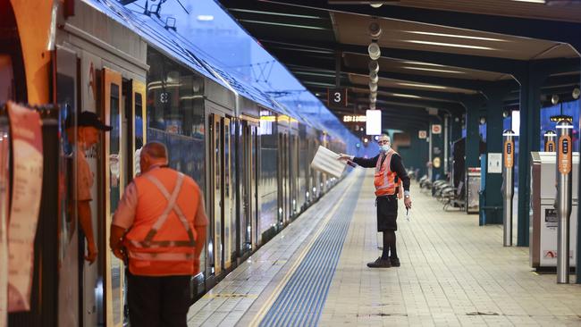
PUBLIC TRANSPORT DISRUPTED BY WEATHER
The train network, already besieged by last week’s shutdown, is also feeling the weather.
The majority of disruption and line closures are happening to the city’s south, with extreme weather conditions and flooding wrecking havoc across the network.
There is currently no service between Cronulla and Sutherland in both directions – with only a limited bus service operating between the two stations – due to the severe weather conditions.
Looking further south, the Southern Highlands Line is partially closed, with no trains running between Campbelltown and Moss Vale due to flooding on the tracks.
There is a limited bus service but NSW TrainsLink are encouraging passengers to delay their travel plans if possible.
T1 Western Line trains are not currently running between Schofields and Richmond – also due to flooding on the tracks – with a limited bus service operating in the meantime.
The T8 line and the Blue Mountains Line are both experiencing delays due to operational issues.
Transport for NSW is urging passengers to delay non-essential travel or use other methods of transport instead of affected lines as heavy rains continue to lash Sydney and regional NSW.
RESIDENTS ORDERED TO EVACUATE
Moorebank: western side of Epsom Rd, between Westbury Stt and Childs Rd.
Chipping Norton: southern side of Newbridge Rd, between Davey Robinson Dr and Milperra Bridge, northern side of Newbridge Rd between Rickard Rd and Riverside Rd, eastern side of Henry Lawson Drive, between Milperra Rd and Auld Ave, Epsom Rd between Westbury St and Governor Macquarie Dr, Riverside Rd between Newbridge Rd and Alfred Rd.
Warwick Farm: Racecourse
Holsworthy: Heathcote Rd, between Harris Creek and Deadmans Creek.
Parts of Picnic Point
Parts of Riverstone
Parts of Cattai
Parts of Windsor
Parts of Yarramundi North
Central Part of Yarramundi
Londonderry
Eastern parts of Vineyard
Parts of East Hills
Sandy Point
Parts of Pleasure Point
Parts of Mulgrave
Parts of North Richmond
Parts of Shanes Park
Parts of South Maroota
Berkeley Vale
Chittaway Bay
Chittaway Point
Long Jetty
Tacoma
Tacoma South
The Entrance North
South Tacoma Rd
McDonagh St
Pollock Ave
Wolseley Ave
Panonia Rd
Wyong Aged Care Facility
Low lying areas around the Wyong Racecourse and the Kooindah Waters Golf Course
Low lying areas along Allison Rd, Old Maitland Rd, Yarramalong, Collies Ln, McPherson Rd, Gavenlock Rd, Mike Jennings Rd and River Rd
Gavenlock Rd area Pacific Highway
(Southern end Anzac Rd – northern end McPherson Rd to the north)

EVACUATION CENTRES AVAILABLE
Blacktown: Blacktown Leisure Centre, Stanhope Pkwy &, Sentry Dr, Stanhope Gardens
Canley Vale: Cabra-Vale Diggers, 1 Bartley St, Canley Vale
Menai: Club Central Menai, 44-60 Alison Cres Menai
Kurrajong: Marroo Christian Center, 182 Mill Rd, Kurrajong
Castle Hill: Castle Hill RSL, 77 Castle St, Castle Hill
Richmond: Richmond Club, 6 E Market St, Richmond
Penrith: Penrith RSL, 8 Tindale St, Penrith
The Entrance: Diggers at The Entrance, 315 The Entrance Rd, The Entrance
EVACUATION WARNINGSFOR RESIDENTS TO PREPARE TO LEAVE
Parts of Woronora
Parts of Mulgoa
Parts of Wallacia
Parts of Jamisontown
Parts of Penrith
Parts of Cumberland Reach
Parts of Lower Portland
Parts of Pitt Town
EARLIER EVACUATION ORDERS IN PLACE
Parts of Oakville: 11pm, March 2
Parts of Freemans Reach: 11pm, March 2
Parts of Ebenezer: 11pm, March 2
Parts of Bligh Park: 11pm, March 2
Parts of Agnes Banks: 11pm, March 2
Pitt Town Bottoms: 11pm, March 2
Parts of Pitt Town: 11pm, March 2
Parts of Sackville North: 11pm, March 2
Parts of Pitt Town (around Percy’s Place Caravan Park): 11pm, March 2
South Windsor Sewage Treatment Plant: 11pm, March 2
Cornwallis and eastern part of Richmond Lowlands: 11pm, March 2
Parts of Gronos Point: 11pm, March 2
Western part of Richmond Lowlands: 11pm, March 2
Parts of Angus: 11pm, March 2
Further parts of Ebenezer: 11pm, March 2
Northern part of Windsor: 11pm, March 2
Parts of Chipping Norton: 3am, March 3
Parts of Milperra: 3am, March 3
Parts of Lansvale: 3am, March 3
Parts of Moorebank: 3am, March 3
Parts of Warwick Farm: 3am, March 3
Parts of Camden: 3am, March 3
More Coverage


Pilot dies after plane crashes into central west paddock
A local man, 48, has died after his plane crashed into a paddock off a rural road west of Dubbo.
Read more

Studious night owls rejoice over Sydney library opening 24/7
Studious night owls and bookworms rejoice: A Sydney council is now opening two of its public libraries 24 hours a day.
Read more