
Bureau of Meteorology: Lockyer Valley deluge sees major flood warning issued
As the Lockyer Valley continues to be lashed by rain and prepares for a cleanup of mammoth proportions, community spirit has shone through with ‘people stepping up everywhere’. SEE THE PHOTOS, VIDEOS
Toowoomba
Don't miss out on the headlines from Toowoomba. Followed categories will be added to My News.
The Lockyer Valley has already been hammered and the region is bracing itself for heavier falls, but the spirit of the region remains strong.
While the weather system that has dumped more than 450mm on the region since Thursday 9am is slowly moving south Lockyer Valley Regional Council mayor Tanya Milligan remains cautious.
With forecasts at times predicting anywhere between 100-200mm still to come, Cr Milligan alongside LVRC staff and emergency services personnel is hard at work.
“It’s fast, furious and frantic here the last few days,” Cr Milligan said.
“We’re constantly receiving forecast updates with some predicting up to 200mm of rain still to come.
“We don’t want to be alarmist but you do have to err on the side of caution in these situations – basing your decisions off the information you have.
“Our number one priority in all of this is the preservation of life – we don’t want anyone to lose a loved one.”

The council has received numerous reports of damage across the region, but Cr Milligan said it was impossible to put a cost on the destruction the rain and flooding has caused.
“It’s almost impossible to put a cost on the damage at this point. It is going to be a massive clean up though,” she said.
“We have more than 140 roads effected in some way. Some of those roads have bridges which will require engineer inspections.
“There is debris everywhere and all manner of other damage we will have to assess and deal with.
“And then there is the human cost of it all as well.
“Our staff have been working 24/7 the past few days.
“Like everyone they’re tired and stressed and we need to make sure we look after them as well.”
The silver lining among all the rain, damage and stress is the people according to Cr Milligan.
“People are stepping up everywhere,” she said.
“During these times you see ordinary people doing extraordinary things.
Volunteers respond to hundreds of calls for help
Emergency services have responded to more than 600 calls for help across the south west and south east regions, including one incident that saw a person winched by a helicopter after their car was trapped in flood waters in the Lockyer Valley.
A Queensland Fire and Emergency Services spokeswoman said in the 24 hours to 3pm today, State Emergency Services volunteers received 158 requests for assistance in the south west region, including Toowoomba, while 456 calls for help were received in the south east region, which includes the Lockyer Valley.
The majority of calls were for water inundation at homes and leaking roofs.
Emergency services on Saturday were called to help a person trapped in their car in flood waters at Atkinson Dam.
Two QFES crews attended about 3pm to find a person sitting on the roof of their car surrounded by flood water.
After setting up a motorised craft and exploring the best way to access the stranded motorist, the QFES spokeswoman said a helicopter was called and the person was winched to safety about 4.20pm.
Earlier today the QFES issued an Emergency Alert for the Lockyer Valley Regional Council. Council advises heavy rainfall and flash flooding is occurring in the region over the next several hours. Residents are urged to remain at home and stay off the roads until storms have passed. If it is unsafe, residents are advised to move to higher ground.
Widespread destruction across region
Residents of the Lockyer Valley will be in for a massive clean-up task as receding flood waters reveal the extent of the damage done by this week’s massive deluge.
Gatton resident Jamie Kowaltzke said he was surprised by how much damage had been done to local roads and bridges.
“The flood waters have done heaps from overnight, but there’s still a lot of water about,” he said.
“I jumped in the car and went for a drive this morning around 5am and came across a disaster zone.”
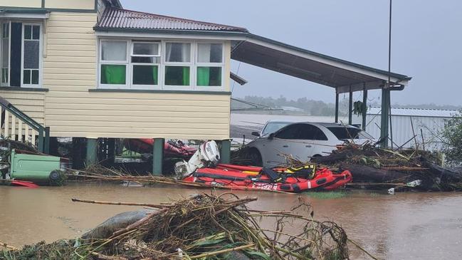
Mr Kowaltzke said flash flooding had caused significant damage to Gatton-Helidon Road, and that a number of cars had been washed away by the swift flood water that gushed through the region overnight.
“I did not expect the rain we had to cause this much damage,” he said.
“Normally when the weather forecasters say we’re going to get a heap of rain it doesn’t eventuate but it hasn’t stopped raining here that’s for sure.”

While inspecting the damage Mr Kowaltzke said he came across a cow stuck on a bridge, wedged between a bale of hay and a guard rail.
“I gave it a bit of a fright and it managed to get out, but then it wanted to fight me,” he said.
“I was just trying to help, so once it got out I wasn’t going to stay to fight.”
Mr Kowaltzke was a Gatton resident during the deadly 2011 floods, and said while this year’s rain event saw similar peaks the surge and power of 2011 wasn’t matched.
“It’s very hard to compare, I think 2011 came much more suddenly, no-one expecting it,” he said
“I think 2011 just hit very fast whereas this flood rose and while it did come up quickly Grantham didn’t get the sudden water through it like in 2011. It was like a tsunami then.
“Hopefully the worst of it is done, everyone will pitch in where possible to help the clean-up.”
Weather experts warn flood levels to worsen Saturday night
The Bureau of Meteorology’s latest flood warning for the Lockyer Valley has forecast flood levels to rise overnight into Sunday, with inundation levels potentially reaching peaks seen in 2013.
In the 24 hours to 9am Saturday, widespread rainfall totals of 150-300mm were observed with more 700mm recorded at Mt Glorious.
Toowoomba Airport has recorded 117mm in the past 24 hours, with 261mm recorded at Flagstone Creek, 334mm at Tenthill, 244mm at Helidon, 240mm at Withcott, 266mm at Forrest Hill, 301mm at Gatton, 203mm at Woodlands Road and 288mm at Upper Sandy Creek.
Since 9am Saturday rainfall has eased significantly, however additional areas of heavy rainfall are forecast for late Saturday and into Sunday which may lead to further rapid or renewed rises throughout the catchment.
A severe weather warning for damaging winds and heavy rainfall remains current for Southeast Coast and parts of the Wide Bay and Burnett and Darling Downs and Granite Belt Forecast Districts.
Rapid river level rises have occurred along the Lockyer Creek in response to very heavy rainfall rates in the headwaters, with several locations recording major flood levels on Friday, and are now falling with levels along Laidley Creek also easing. Further rapid rises are possible with forecast rainfall.
The Lockyer Creek at Gatton is expected to be below the moderate flood level of 10m and easing (no manual observations available). Renewed river level rises are likely during Saturday and the creek level may exceed the moderate flood level of 10m on Saturday evening.
Laidley Creek at the Showground Weir Alert is now below minor flood levels and the creek level at Laidley is expected to also be easing. Water levels in Narda Lagoon are steady about the level of the Narda Lagoon Bridge. Renewed rises are expected with forecast rainfall during Saturday and the Laidley Creek at Laidley may exceed the moderate flood level of 6m Saturday evening.
EARLIER:
A weather expert has explained what has made this deluge different to the 2011 floods, but has still had the enormous force to turn the Lockyer Valley into an inland sea and left people trapped on their properties and caused widespread destruction.
The Lockyer Valley has copped a barrage of heavy rain in the past 24 hours, but as the region faces major flooding an expert at the Bureau of Meteorology pointed to one key difference between this weather event and the horrific 2011 floods.
At 5.45pm on Friday February 25 the Queensland Fire and Emergency Services issued
an Emergency Alert for residents in the Lockyer Valley Regional Council area, warning of flash flooding with roads and bridges impacted.
“Areas of Lockyer Creek within the Somerset Regional Council area are at risk over the next several hours,” the warning stated.
“If you were impacted by flooding in 2011 or 2013, or are in a low lying area near the Lockyer Creek, you should move to higher ground and seek shelter. Warn you neighbours and head to higher ground now.”
Since 9am today, Gatton has copped 200mm, Sandy Creek Road 203mm, Flagstone Creek 180mm, Helidon 167mm, Atkinson Dam 162mm and Wivenhoe Dam 190mm.

BOM senior meteorologist Felim Hanniffy said the heavy rainfall was on top of the 100-130mm the areas copped overnight.
“It’s safe to say that some of these areas in the Lockyer Valley and Grantham regions have seen in excess of 300mm in the last 24 hours, and most of that has fallen after midnight,” he said.
“These are really extreme totals in a short duration of time, and it’s the speed in which the rain hit which has caused the rivers to rise quite dramatically.”
Mr Hanniffy said the difference between this rain event and the devastating 2011 floods was how quickly the large rainfall totals accumulated.
“In the lead up to the 2011 floods it was very wet right the way through January, whereas this year we have had periods of very wet weather but also a bit of a reprieve that’s allowed regions to dry out,” he said.
“There was very wet weather in November and December last year, but then a bit of a gap before the next onslaught so at least this year river levels and catchments weren’t as saturated as what we saw in 2011.”
In Toowoomba today was also the wettest day since 2013 with 146mm in the last 24 hours.
CURRENT LOCKYER VALLEY FLOOD WARNINGS:
Rapid river level rises have occurred along Lockyer Creek in response to very heavy rainfall rates in the headwaters with several locations recording major flood levels including Helidon and Sandy Creek Road. Major flooding is occurring along the Laidley Creek, and further rapid rises are likely with continued heavy rainfall.
The BOM reports that there are no current observations for Gatton manual gauge, however, based on levels at nearby gauges, the river level is expected to be above the minor flood level of 7m and rising. Rapid rises are expected at the Lockyer Creek at Gatton and river levels are expected to exceed the moderate flood level of 10m Friday afternoon. The river level may exceed the major flood level of 15m later Friday afternoon.
There are no current observations for the Laidley manual gauge, but based on data from Showground Weir, the BOM believes creek levels are currently around the level of the Campbells Bridge (Laidley) with major flooding experienced during Friday afternoon. Water levels in Narda Lagoon are also rising and are now 0.25m above the level of the Narda Lagoon Bridge. The Laidley Creek at Laidley is likely to remain around the Campbells Bridge crossing (8.5m) during Friday afternoon.
There are no current reliable data for the Lockyer Creek at Glenore Grove, however river levels are likely to be below the minor flood level and rising. The Lockyer Creek at Glenore Grove is likely to exceed the minor flood level of 8m later Friday afternoon. The river level may reach the moderate flood level of 11m Friday evening.
More Coverage

Originally published as Bureau of Meteorology: Lockyer Valley deluge sees major flood warning issued

Watch: Toowoomba school to debut ‘savage’ new production
A top Toowoomba school is set to debut a “savage” production based on one of the most infamous young adult texts of the 20th century. Watch our preview here:

‘Absolute joke’: Mayor fires up as true cost of $700m budget revealed
Toowoomba mayor Geoff McDonald has fired up at the upper levels of government while defending enormous increases to rates, levies and charges. How much it will cost your family here: