
‘Up to 100mm’: Queenslanders in for drenching as much of state placed on flood watch
Brisbane has recorded its wettest spring in 11 years and other parts of the state have been hammered as authorities warn the risk of flooding is growing.
QLD weather news
Don't miss out on the headlines from QLD weather news. Followed categories will be added to My News.
Meteorologists have warned dangerous flash flooding could be on the cards as even more heavy rain is on the way for Queensland.
The risk of flooding across southern and eastern Queensland has increased this afternoon with the Early Warning Network has increased its flood threat level to amber.
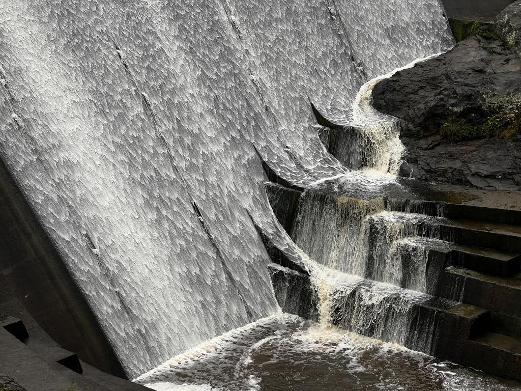
A lingering trough over the state will continue to bring further showers and thunderstorms today and tomorrow where catchments have already been saturated by rainfall.
Widespread minor to moderate flooding is likely across the flood watch area over the next few days, with isolated major flooding possible in areas affected by thunderstorms.
The Bureau of Meteorology says Taroom, west of Maryborough, could experience major flooding overnight on Wednesday, with moder flooding possible at Theodore and Baralaba.
Flood warnings are current for many catchments across southern and central Queensland with renewed river and creek level rises expected in association with heavy rainfall.
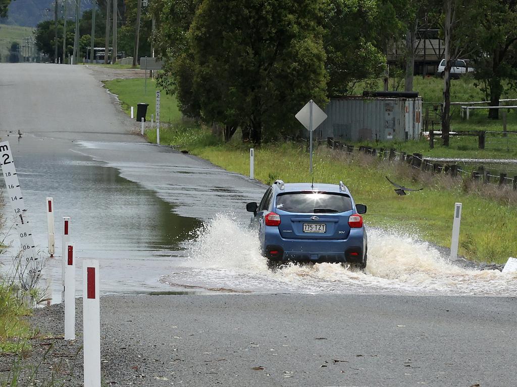
Meanwhile, falls of up to 30mm an hour have drenched parts of central Queensland on Tuesday morning, while a truck driver had a lucky escape after his vehicle became trapped in flood water outside Goondiwindi.
Rain records for the month have already been broken, with Roma’s almost 200mm marking the wettest November since records began 150 years ago.
Brisbane had its wettest spring in 11 years with 427mm doubling its long-term average.
Sky News Weather Chief Meteorologist Tom Saunders said more significant rain was on the way.
“There’s a thick band of heavy cloud which stretches from central Queensland to South East Queensland and that’s delivering heavy rain which will continue throughout the day,” he said.
“For central Queensland, it will remain heavy right through the afternoon and for the southeast, there’s every chance some areas will get heavier through this afternoon and this evening and also early tomorrow morning.
“There’s a risk of dangerous flash flooding as a result.”
Catchments across much of Queensland are already saturated and further rain poses the risk of river flooding.
“All of our models are indicating there is potential for well over 100mm of rain in a 24 hour period and the bureau is warning up to 80mm falling in a six hour period,” Mr Saunders said.
“All together in a 48 hour period it is possible that some places will have up to 200mm.”
Flash flooding across Queensland has contributed to more than 200 road closures as heavy falls continue to lash large parts of the state
The RACQ reminded motorists of the key message, “if it’s flooded, forget it”.
Road closures have impacted the state as far west as Birdsville, as far north as Atherton, and right down to the border at Coolangatta.
Roads affected by flood water stretch from the southeast corner, through Central Queensland and the Far North.
Flooded areas affected by road closures include Corfield, Kowguran, Wondalli, Goondiwindi, Dalby, St George, Birdsville, Cunnamulla, Beaconsfield, Kogan, Rosewood, Isisford, and Longreach.
There are also 27 roads Queensland temporarily closed because of flash flooding in surrounding regions.
Mr Saunders said about 60 per cent of Queensland was still in drought and while flooding wouldn’t answer the problem, many farmers would be “ecstatic”.
One of those is beef farmer Arlie Becker from Dulacca where some properties have recorded 85mm today, and more than 300mm for the month.
“As a whole it has been very welcomed but there may be some that didn’t get their harvest completed,” Ms Becker said.
“We have beef cattle so it’s very welcomed for us.”
Ms Becker said Bogandilla Ck which runs through her Western Downs farm was full.
Rain is expected to ease across the western parts of Queensand on Wednesday but will continue through the southeast.
“The rain will ease in South East Queensland later tomorrow so by the time we get to Thursday we’re not expecting any significant rain across the state,” Mr Saunders said.
According to the Bureau of Meteorology, a shift in wind direction spared Brisbane of heavy rain forecast over the past weekend but more wet weather was on its way.

Emergency services were called to the intersection of the Cunningham Highway and Kerimbilla Road about 3.25am Tuesday morning following reports a truck had left the highway and was trapped in fast-flowing floodwater.
A Queensland Fire and Emergency Services spokeswoman said a swift water rescue crew was called to the scene and rescued the truckie.
“The truck driver was in the cab so the crew made contact in their rescue boat and paddled over to the vehicle and then and brought him to dry ground,” the spokeswoman said.
Meanwhile, a man has been freed from floodwater in Glenview onlookers came to his rescue.
Emergency crews were called to Stevens Rd, Glenview, just before 9am on Tuesday, November 30 after reports a car had become trapped in floodwater in Glenview.
Other drivers were able to help push the car out of the floodwater and the man did not require medical attention.
Floodwaters had cut Stevens Rd near Connection Rd.
Calls for help were made to emergency services about 8.50am on Tuesday, November 30, requesting help for a person trapped in floodwaters.
Queensland Ambulance Service spokesman said the male truck driver was not trapped in the cab of the vehicle.
Paramedics assessed the man and he did not require transport to hospital.
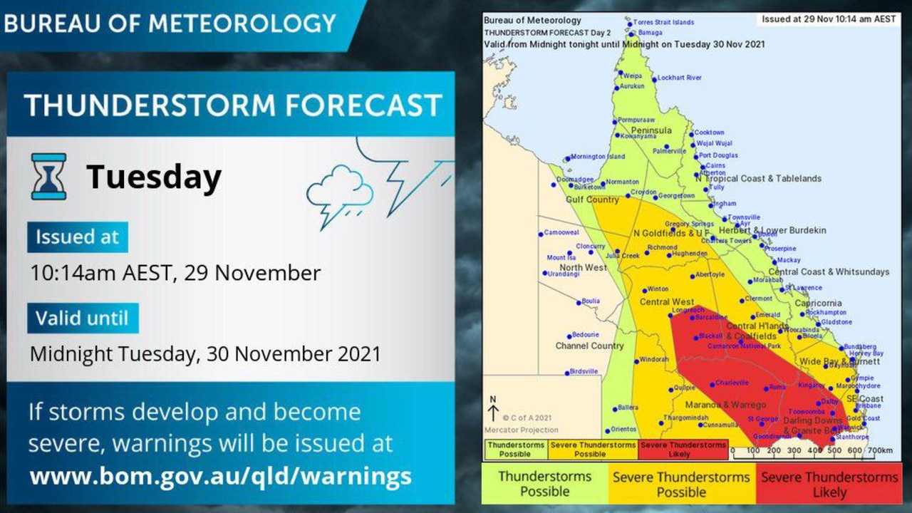
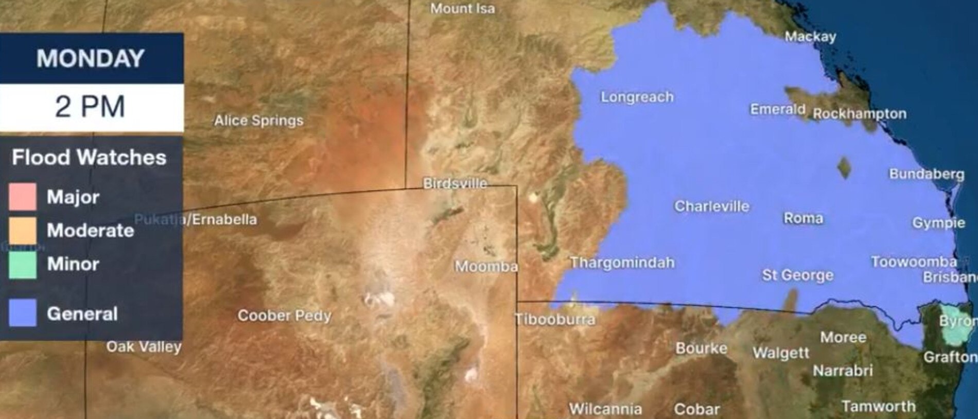
A Flood Watch and multiple Flood Warnings are current over southern and eastern Queensland.
Locations that may be affected include Warwick, Dalby, Roma, Stanthorpe, Goondiwindi and Tara.
A second warning for similar conditions was issued for people in parts of the Gulf Country, Northern Goldfields and Upper Flinders, North West and Central West forecast districts.
BOM meteorologist Jackson Browne said rich tropical moisture was lying in wait on Monday while an upper level trough over southern Australia moved east to aid the development of widespread rain.
“Rainfall broadens inland and consolidates early Tuesday as our upper trough looms over head,” Mr Browne said.
“Cumulative falls of 50mm to 100mm are likely out to Wednesday with lesser amounts further west.
“Severe thunderstorms are expected to develop, bringing the risk of heavy rainfall, large hail and damaging winds.”
Mr Browne said “hit and miss” storms would bring unwelcome rainfall to already sodden areas.
Paget, near Mackay, recorded 305mm in the 24 hours to Monday morning.
There’s a general flood watch for much of the state from Brisbane, to the state’s southwest and up to Mackay.
A major flood warning is current for the lower Macintyre River at Goondiwindi which was expected to peak near 9.7m overnight Monday and into Tuesday.
CATCHMENTS ON FLOOD WATCH
Belyando and Suttor Rivers to Burdekin Falls Dam
Dawson and Don Rivers
Comet and Nogoa Rivers
Connors, Isaac and Styx Rivers and Plane Creek
Calliope River
Boyne River
Baffle Creek
Kolan River
Burnett River
Burrum and Cherwell Rivers
Mary River
Noosa River
Sunshine Coast Rivers and Creeks
Pine and Caboolture Rivers
Upper Brisbane River
Lower Brisbane River(Tributaries of the lower Brisbane River only)
Logan and Albert Rivers
Gold Coast Rivers and Creeks
Condamine Rivers
Macintyre River
Weir River
Moonie River
Balonne River
Wallam and Mungallala Creeks
Warrego River (QLD)
Paroo River (QLD)
Bulloo River (QLD)
Barcoo River(Upper Barcoo)
Thomson River(Upper Thomson)
FULL LIST OF LONG-TERM ROAD CLOSURES
Kennedy Developmental Road
Corfield / Middleton / Warburton
Leichhardt Highway
Kowguran
Wyaga Road
Wondalli
Cedars Road
South Bingera / South Kolan
Memerambi Gordonbrook Road
Wilkesdale
Barwon Highway
Goondiwindi
Bollon Charleville Road
Boatman / Nebine
Dalby Cecil Plains Road
Saint Ruth
Dalby Kogan Road
MacAlister
Texas Yelarbon Road
Beebo
Toowoomba Cecil Plains Road
Norwin
Dawson Developmental Road
Tambo / Windeyer
Tallebudgera Creek Road
Tallebudgera Valley
Prairie Road
Prairie
Moore Park Road
Gooburrum / Welcome Creek
Texas Yelarbon Road
Glenarbon
Oakey Pittsworth Road
Motley
Dawson Highway
Rhydding / Roundstone
Diamantina Developmental Road
Adavale / Charleville
Jandowae Road
Dalby
Diamantina Developmental Road
Bedourie
Cordillo Access
Birdsville
Dalby Cooyar Road
Irvingdale
Degulla Road
Hobartville / Surbiton
Carnarvon Highway
St George
Warrego Highway
Jackson South
Hungerford Eulo Road
Hungerford Road
Hungerford
Dalby Cooyar Road
Dalby
Moonie Highway
Ducklo
Cramsie Muttaburra Road
Longreach
Hughenden Muttaburra Road
Hughenden / Tangorin
Hughenden Muttaburra Road
Hughenden / Tangorin
Jericho Texas Road
Garfield / Jericho
Gladstone Monto Road
Boyne Valley
Moonie Highway
Ducklo
Leichhardt Highway
Billa Billa
Moonie Highway
Nandi
Dalby Kogan Road
Kogan
Gore Highway
Goondiwindi
Bunya Highway
Dalby
Warwick Yangan Road
Swan Creek
Amosfield Road
Dalcouth
Ilfracombe Aramac Road
Ilfracombe
Dalby Kogan Road
Kogan
Gregory Highway
Wyuna
Leichhardt Highway
Goondiwindi
Leichhardt Highway
Grosmont
Clermont Alpha Road
Alpha / Surbiton
Rosewood Warrill View Road
Rosewood
Haigslea Amberley Road
Walloon
Leichhardt Highway
Banana
Dalby Kogan Road
Beelbee
Dirranbandi Hebel Road
Dirranbandi
Beaconsfield Road
Beaconsfield
Urandangi Road
Urandangi South Road
Dajarra / Waverley
Isisford Emmet Road
Isisford
Jandowae MacAlister Road
Jimbour West
Moray Carmichael Boundary Road
Belyando
Ducklo Gulera Road
Kumbarilla
Old Charleville Road
Cunnamulla
Kings Bridge Road
Sandy Ridges
More Coverage


Monster weather system brings storm, heavy rain to Qld
Brisbane and surrounding parts of the southeast have been hit by storms and heavy rainfall this afternoon as a 3000km-long monster low moves across the state.

Wild storms, polar blast as 3000km monster low barrels towards Qld
The system, which stretches 3000km from north to south and encompasses 30 per cent of Australia, is forecast to pack a punch when it hits Queensland.