
Emergency alert issued as FNQ cops 245mm monsoonal drenching
Far north Queenslanders are back on flood watch as the region cops a 245mm+ drenching, with a monsoon trough bringing heavy rain and thunderstorms to still recovering residents.
QLD weather news
Don't miss out on the headlines from QLD weather news. Followed categories will be added to My News.
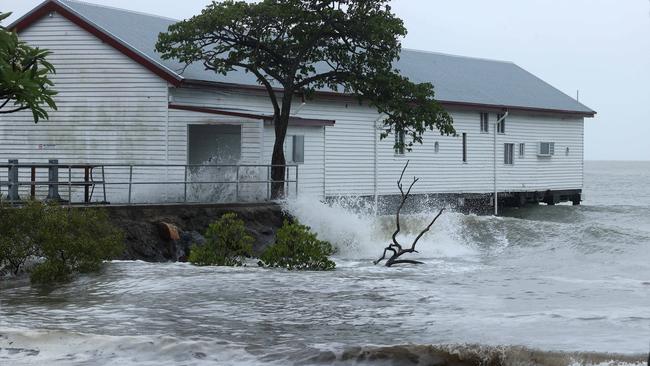
An emergency alert and flood watch has been issued as Far North Queensland was smashed by monsoonal rains in excess of 200mm overnight, with heavy rain and possible storms continuing into Friday.
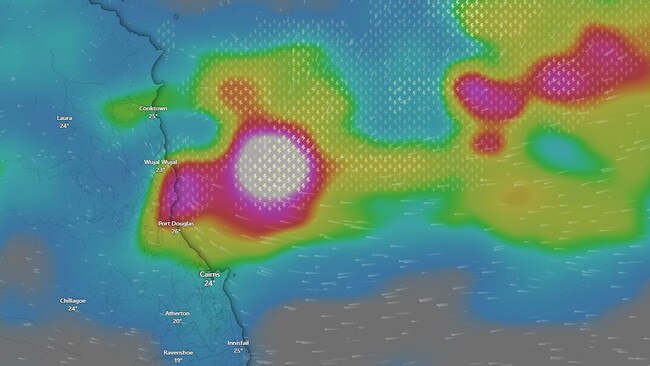
Parts of the far north have been put on flood watch as the slow-moving monsoon trough tracks over the Queensland coast with the Bureau of Meteorology issuing a severe weather warning for the northeast tropical coast including Port Douglas, Mossman and Wujal Wujal early Friday morning for heavy rainfall.
The warning was cancelled at 11am.
“The immediate threat of severe weather has passed,” The Bureau said.
“There is a slight chance of heavy rainfall developing about the North Tropical Coast again Friday night so further warnings will be issued if necessary.”
Queensland Fire and Emergency Services also issued an emergency alert for the areas of Port Douglas, Mossman and Newell Beach on Friday morning to conserve water.
“The Douglas Shire Council advises residents in these areas to conserve water by ceasing non-essential water use, as water infrastructure in the area has been affected by recent rainfall,” the alert stated.
QFES issued a second emergency alert on Friday at 10:53am for Alexandra Range and Noah Range.
“An emergency alert has been issued from the Douglas Shire Council.
“Council advises Cape Tribulation Road at Alexandra and Noah Range is closed due to dangerous conditions. The Daintree Ferry is also closed until further notice.”
Premier Steven Miles said Queensland was prepared, as the emergency alert was issued.
“This has always been our concern that weather events struck before the proper wet season had started and so we’ve been working to get those communities back and ready for when more bad weather strikes and now we have these forecasts that it will be coming,” he said.
“The work that we’ve done to get the roads reopened, to get the power back on, to get people back into their homes or crisis accommodation will have them well prepared.
“We’ve also made sure that we’ve rotated our first responders to manage their fatigue … to make sure that they’ve had some days off between the disasters if and when the next one strikes, and we know in Queensland the next disaster is always just around the corner and we have to make sure we’re ready.”
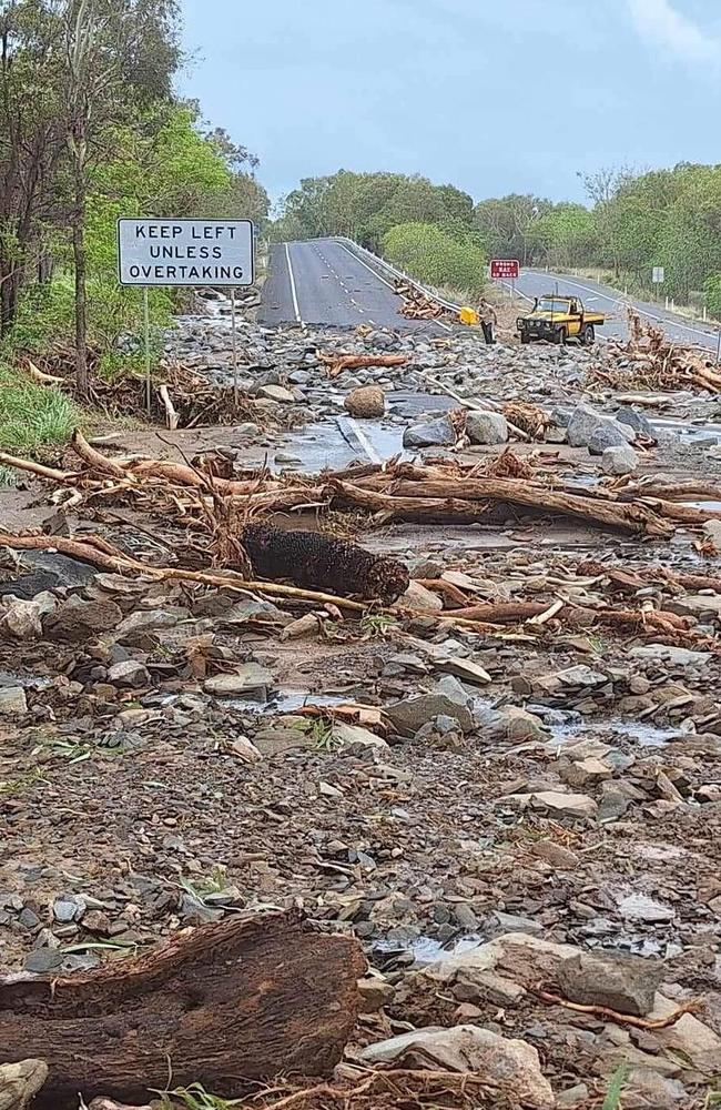
Residents in the far north have received little break from the rain as they continue to recover from the devastation wreaked by ex-tropical Cyclone Jasper.
South of Cairns overnight received falls up to 180mm, with Tully copping 172mm and Saltwater Creek near Innisfail recorded 117mm.
Areas around Port Douglas and the Daintree copped even heavier falls with Stewart Creek hitting a whopping 245mm, 216mm in Daintree Village, 176mm in Murray Flats and 182mm at Marco Street.
“We have warnings out for a couple of those rivers including the Tully, Mulgrave and Russell rivers as we anticipate we will see rain continuing in those areas with potential river rises,” Mr Hayes said.
“We will be seeing that heavy rainfall, but we don’t expect it to be as intense as Jasper … it will be relatively normal falls for monsoon activity.”
The Daintree Ferry has been forced to close operations once again after heavy rainfall caused dangerous conditions on the Daintree River.
“The Daintree River is rising quickly and debris is flowing down the river,” Tourism Port Douglas Daintree said in a Facebook post.
“Conditions are too unsafe to continue. Operations will re-open when it is safe to do so.”
The ferry service connects the northern Daintree Rainforest and Cape Tribulation with the rest of far-north Queensland and only just reopened after Cyclone Jasper in late December.
However residents can breathe a sigh of a relief that twin lows could form, with one low in the Northern Territory (03U) tracking over land, reducing the risk of a cyclone forming.
“We are analysing a low around the Northern Territory which has tracked over land, reducing the likelihood that it will intensify into a cyclone to 10 per cent,” The Bureau’s Daniel Hayes said.

While the 03U low is expected to continue over land in the Northern Territory over the weekend, as it slowly begins to move towards the southeast, the probability of it forming into cyclone slightly increases again.
The Bureau is still waiting to see if a low forms in The Gulf of Carpentaria, which could be as early as this afternoon.
“If it does form the expectation is that it will be slow moving as it tracks towards the coral sea, with the probability of it forming into a cyclone only a 15 per cent chance.
“For the most part we are seeing these tropical lows bringing showers and storms rather than cyclone development,” Mr Hayes added.
The heavy rain in the north tropical coast should begin to ease later on Friday afternoon, however it will be a brief reprieve as the monsoon trough is expected to hang around for quite some time.
“The monsoon trough continues to strengthen and we will see widespread rain and thunderstorms with heavy falls through the weekend and into next week.”
Towards the southeast, residents can expect some shower activity for the weekend, but an upper level feature will bring down the tropical moisture into next week.
“Storm activity will remain around the southwest and the Channel Country for the weekend, but may change into next week as the that tropical moisture brings down more showers,” Mr Hayes said.
More Coverage


Ice ice baby: Spectacular images of unseasonal frost as Qld freezes
Queensland’s overnight temperatures will increase to double digits in the coming days, following the coldest start to winter in 16 years, bringing frost and ice to many regions. SEE THE PHOTOS

City’s coldest June start in 16 years, feels like MINUS 9.8C out west
Southeast Queensland is shivering through its coldest morning in more than 15 years but feels-like temperatures have dropped to insane levels in the southern inland.