
Warwick, Granite Belt remain on flood watch with 45mm - 100mm rainfall on cards
‘Looking at close to a month’s worth of rain’: Experts say 80mm+ rain in only hours on the Granite Belt could be just the start of an intense weather system expected to batter Warwick and surrounds.
Warwick
Don't miss out on the headlines from Warwick. Followed categories will be added to My News.
Data from the Bureau of Meteorology indicates rain gauges in Stanthorpe and Applethorpe scored about 86mm each between 9pm on Wednesday through to 2am on Thursday.
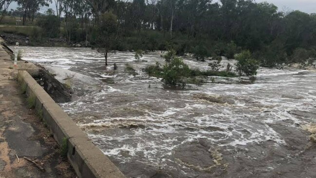
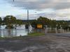
The huge rainfall totals have reportedly caused flash flooding from Quart Pot Creek and Accommodation Creek, cutting off more than a dozen roads across the region.
Stanthorpe resident Hannah Mann wrote on social media that she and her family received “nearly 100mm (Wednesday night)”, and fellow resident Morris Mann said the flooded roadways were already wreaking havoc.
“Yep it’s here, watching the cars doing the river run. We need a pedestrian crossing here just to cross the street, it’s madness,” they said.
Storm King Dam was at 100 per cent capacity prior to the deluge, with BOM data now putting it at a minor to moderate flood level.
Connolly Dam and Leslie Dam remain at 100 per cent and 60.9 per cent capacity respectively.
BOM meteorologist Felim Hanniffy said Southern Downs residents could receive another massive downpour of 60mm to 100mm on Thursday, with latest warnings suggesting storms could drive totals up to 150mm.
He said Stanthorpe and Granite Belt residents were at greater risk of flash and riverine flooding due to the huge overnight totals.
“It’ll be very much dictated by where the thunderstorms move, but if they move over you then for those areas you’re looking at close to a month’s worth of rain,” Mr Hanniffy said.
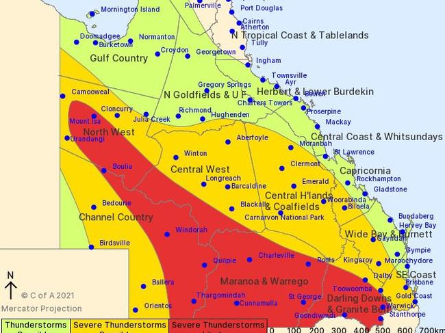
“This week so far has been very wet, and the ground has already absorbed what it can, so anything else from the falls is flowing into the catchment and you’re going to get a quick response from the river systems.
“The atmosphere remains very, very moist – we’re talking moisture levels you’d more see in January and February – and that’s why there’s so much moisture available for storms to deliver those high totals.”
More than a dozen roads across the Granite Belt remain closed to motorists, with Southern Downs Regional Council urging residents to avoid entering flood waters.
See the full list of road closures below:
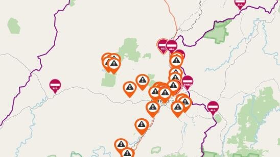
Granite Street, Stanthorpe
Railway Street, Stanthorpe
Lock Street, Stanthorpe
Folkestone Street, Stanthorpe
Britannia Street, Stanthorpe
Amosfield Road, Stanthorpe
West Road, Stanthorpe
Eukey Road, Stanthorpe
Mount Stirling Road, Glen Aplin
Glen Niven Road, Glen Niven
Amiens Road, Applethorpe
Border Road, Applethorpe
Aerodrome Road, Applethorpe
New England Highway at Lyra
Elks Lane, Broadwater
Amiens Road, Thulimbah
Dalcouth Road, Kyoomba
Sugarloaf Road, Kyoomba
Reid Road, Severnlea
Sundown Road at Accommodation Creek crossing, Ballandean
Bents Road, Ballandean
If you require emergency assistance, contact emergency services on triple-zero or the SES on 132 500.


Cattle killed in truck rollover near Qld border
A number of cattle have died after a truck rolled on a major highway near the Queensland border. Warning: Graphic images.

Junior league game cancelled after police arrest teenage boy
Queensland Rugby League have started disciplinary proceedings after the arrest of a teenage boy following an alleged altercation forced a junior rugby league game to be cancelled. Details here.