
Tin Can Bay region records 350mm falls with system to deliver significant rain to southeast Queensland
One Queensland community has recorded almost 350mm in less than 24 hours while Brisbane cops a drenching, triggering flash flooding and road closures. Commuters are facing major delays as the Brisbane CBD descends into chaos. FULL LIST OF RAINFALL TOTALS
QLD News
Don't miss out on the headlines from QLD News. Followed categories will be added to My News.
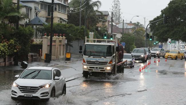
HEAVY rainfall is causing roads to flood across Brisbane and southeast Queensland, with extensive delays and numerous crashes this morning.
BOM forecaster Kimba Wong said the rain will continue to fall over the coming hours, days and into next week.
This morning, Brisbane was hit by “drenching rain” with over 100mm falling in several parts of the city including Lytton and Luggage Point, just east of the airport.
The Sunshine Coast had over 200mm of rain in Tin Can Bay and Coops Corner, while the Gold Coast recorded falls of up to 80mm across the city.
Lifeguards on North Stradbroke Island closed the area’s beaches, urging swimmers and surfers to stay out of the water due to dangerous conditions.
Flash flooding was reported in the Redlands with water blanektting the areas after this morning’s deluge.
SCROLL DOWN TO SEE HOW MUCH RAIN YOU’VE HAD
“We have had some showers and thunderstorms pushing into some drought-stricken areas as well,” Ms Wong said.
“Widespread throughout the Darling Downs we’ve had some rainfall totals of 10-20mm so some really useful rainfall there.”
More showers and storms are forecast over the next few days and over the weekend, but heavy rain like we saw today is not predicted to return until Monday.
“We do have a flood watch that is current for the east coastal catchments south of about Caboolture to the New South Wales border for the potential for flash flooding and river rises over the next couple of days,” Ms Wong said.
Traffic wasn't the only problem caused by this morning's flash flooding! Some cars were caught in a tricky spot on Didswith Street, East Brisbane. Please keep an eye on weather warnings and move vehicles to higher ground if necessary. #BneStorm pic.twitter.com/lgjsfksJRa
— RACQ (@RACQOfficial) February 6, 2020
Earlier today, flooding, crashes and heavy congestions were reported across some of Brisbane’s major thoroughfares.
Multiple crashes and heavy congestion was reported south of Brisbane with blocked lanes and heavy congestion on the Gateway Motorway northbound.
Paramedics were called to a two-vehicle crash that blocked northbound lanes of the Gateway Motorway at around 9.50am in Eight Mile Plains.
One patient was taken to hospital with leg injuries.
There are delays back to Stretton after a crash on the Gateway Motorway. Speed limits have been reduced and long delays are expected. Please pack your patience or plan an alternative route. #RACQTrafficAdvice #BneTraffic pic.twitter.com/X6vBfE5XuN
— RACQ (@RACQOfficial) February 6, 2020
A second crash occurred on the Pacific Motorway near Helensvale on the Gold Coast with small delays reported.
Paramedics were not required at this scene.
A red alert was earlier today issued due to flash flooding in South Brisbane on Vulture Street. The road has now reopened.
The Centenary Hwy outbound was also heavily congested due to flooding and a broken down vehicle at Jindalee.
The left lane was blocked after the Jindalee Bridge, with congestion extending north of the Moggill Road exit.
Stationary vehicle in #Indooroopilly heading south on the Western Fwy just after the Moggill Rd exit in the right lane. #bnetraffic pic.twitter.com/dy1570GKTp
— QLDTrafficMetro (@QLDTrafficMetro) February 6, 2020
The Department of Transport and Main Roads issued the alert saying, “due to water over the road on Vulture Street, East Brisbane, traffic has been diverted onto Grey Street.
“All approaches from the eastern suburbs experiencing long delays”
All Brisbane City Council buses are currently delayed up to an hour due to severe weather conditions and heavy traffic congestion.
Commuters are facing delays of up to 45 minutes with the city’s main roads heavily congested.
Meanwhile, a swift water rescue team is on the scene of a flooded creek stranding at Glenwood, north of Gympie.
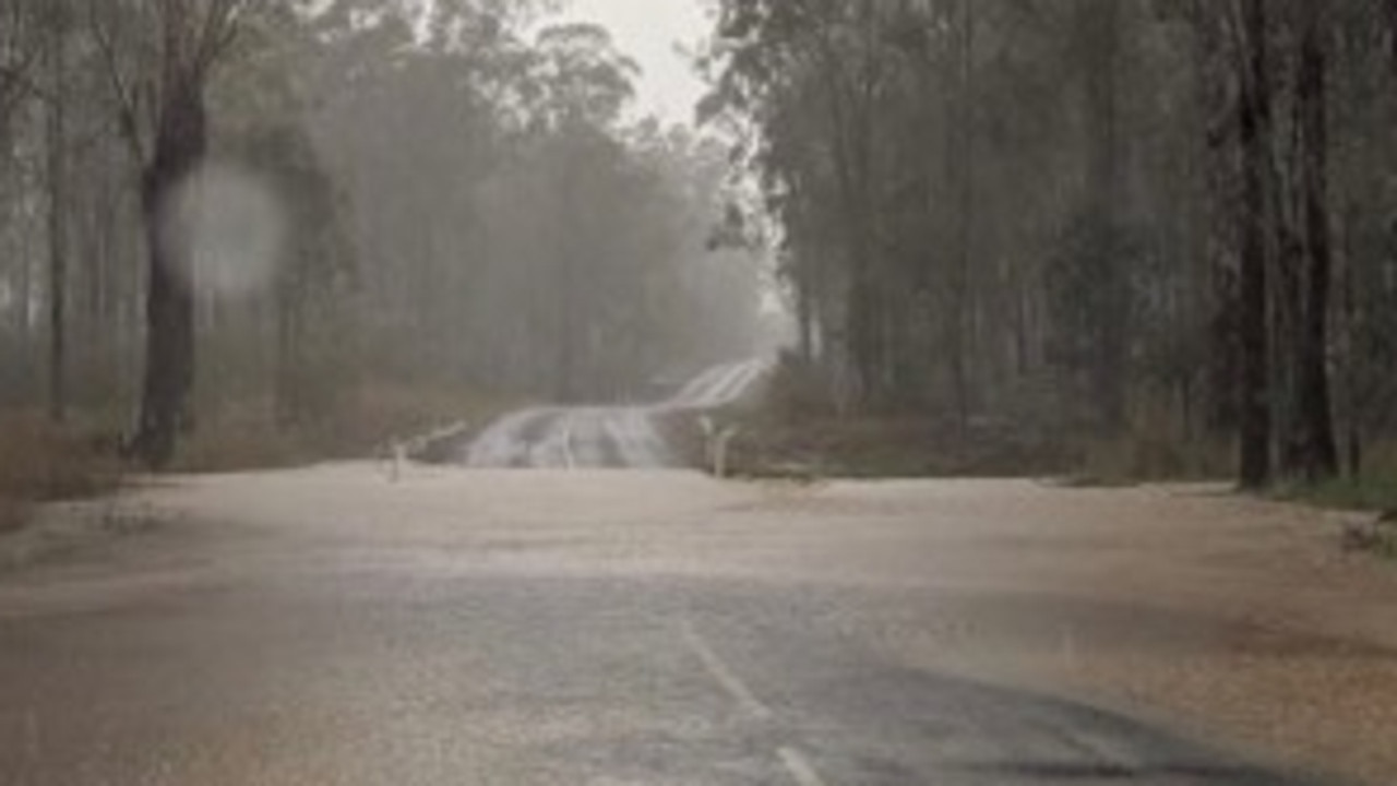
A call was made about 7.30am on Arborthree Road saying a silver sedan was wedged on the other side of a creek against a tree north of Noosa.
It is believed the car was washed off of the causeway in Glenwood into a creek and wedged into a tree on the other side.
The owner of the vehicle was at the scene but did not require rescuing and is safe.
Paramedics and Police also attended the scene but no one was injured and the swift water rescue has since been called off.
BOM warns of heavy rainfall that may lead to flash flooding
Queensland weather: Roads flood as drenching continues
Brisbane weather: City to receive over 100mm in next two days
Predictions of some parts of Queensland receiving 500mm of rain remain on track after totals of almost 350mm in less than 24 hours.
The Wide Bay region was hardest hit, with Mount Elliott recorded 342mm between 6pm Tuesday and 1am today.
Similar falls were recorded across Tin Can Bay, including Coops Corner (340mm), Tin Can Bay (303mm), Mt Bilewilam (286mm) and Bidwell, near Tiaro (255mm).
In Brisbane, 40mm has been recorded at Archerfield, 32mm at Cape Moreton and 28mm at Redland. This morning, Bracken Ridge has copped 21mm in less than hour.
The Sunshine Coast has copped a soaking, with almost 62mm at Maroochydore, 70mm at Tewantin and 30mm at Nambour.
Meanwhile, Wappa Dam, which provides water for the Sunshine Coast, is overflowing.
Wappa Dam is now spilling excess water. Details https://t.co/6b9lv0xsfA pic.twitter.com/MbzmKMfrOJ
— Seqwater (@Seqwater) February 6, 2020
Storm chasers tracking the extreme weather system remain confident of substantial rainfall across southeast Queensland from this morning until 4am tomorrow.
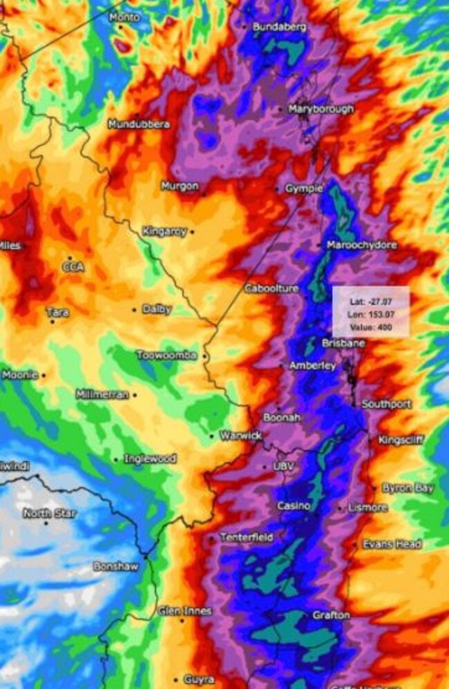
Higgins Storm Chasing last night posted on its Facebook page the latest rainfall forecast data from WeatherWatch.net.au which forecasts ongoing heavy rainfall from Bundaberg South to the Coffs Coast in northern New South Wales.
Heavy rainfall is being recorded across the southern Wide Bay and northern Sunshine Coast, with more expected early Thursday morning. Initial Flood Warnings have been issued for the Mary, Burrum and Cherwell Rivers. More information see https://t.co/FBmpsInT9o pic.twitter.com/IMZ305rYWS
— Bureau of Meteorology, Queensland (@BOM_Qld) February 5, 2020
“Either it knows something big is brewing or it’s just off it’s head,” Higgins stated in the post.
“Falls of more than 200mm have been observed across the Tin Can Bay Area since 9am and some of these areas may push in excess of 300mm by 9am with event totals in excess of 450mm possible.”
BOM forecaster Jonty Hall, is predicting big falls in Brisbane and the Gold Coast today.
“There’s a good chance of seeing falls of up to 90mm in Brisbane, we’ve got some heavy falls right now which may last for an hour two.
“It may ease later in the morning but pick back up in the afternoon and Southeast Queensland can expect another 12 or 18 hours of some heavier totals.”
“The potential of storms will increase a bit during the day which would create higher rainfall intensity.”
RAINFALL TOTALS
Brisbane
Brisbane City – 74mm –
Caboolture – 62mm –
Aspley – 70mm –
Geebung – 67mm –
Bowen Hills – 79mm –
Toombul – 65mm –
Toowong – 65mm –
Everton Hills – 62mm-
Lytton – 106mm –
Luggage Point – 104mm –
Carindale -65mm –
Bulimba – 98mm –
Albany Creek – 63mm –
Mt Gravatt – 47mm
Wynnum Bowls Club – 95mm –
Rochedale – 44mm
Gold Coast
South Stradbroke – 57mm
Miami -16mm
Beenleigh – 28mm
Gold Coast – 28mm
Coolangatta – 18mm
Queensland
Mount Elliott – 342mm
Bundaberg – 37mm
Hervey Bay – 90mm
Tin Can Bay – 230mm
Coops Corner – 259mm
Doonan Creek – 164mm
Eumundi – 139mm
Sunshine Coast Airport – 67mm
Maroochydore – 52mm

Jet-setting Premier racks up double hours in taxpayer-funded planes
Premier David Crisafulli has logged a whopping 46.3 hours of flight time between January and March — far outstripping former Labor Premier Steven Miles and Annastacia Palaszczuk.

Brisbane’s speed shame: Drivers caught 200km/h in 60 zones
Drivers have been caught at speeds of more than 200km/h in 60 zones across Brisbane, with nearly one in six drivers ignoring slow down signs across the city.