
Brisbane weather: City to receive over 100mm in next two days
Three people have been rescued from fast-moving flood water as a deluge sets in across the state. Forecasters say Brisbane and southeast Queensland is facing significant rainfall this week.
QLD weather news
Don't miss out on the headlines from QLD weather news. Followed categories will be added to My News.
THREE people have been rescued by Swift Water Rescue and a flood warning has been issued for much of southeast and southern Queensland as the region braces for a deluge from Thursday.
Flood waters in Roma stranded trio between an overflowing creek and a river.
Emergency services were called and Queensland Fire and Emergency Services Swift Water Rescue team moved them onto dry land.
The trio is being assessed by paramedics.
Meanwhile, minor flooding is forecast for coastal catchments from south of Caboolture to the NSW border, and southern inland catchments.
âš ï¸ #Flood Watch area updated to cover catchments between #Caboolture and NSW border. Heavy rainfall now expected further south on Thursday morning ðŸŒ§ï¸ Follow advice of local emergency services @QldFES. See Warnings for updates: https://t.co/g3inmKz9li #IfItsFloodedForgetIt pic.twitter.com/vO6uP4q7Av
— Bureau of Meteorology, Queensland (@BOM_Qld) February 5, 2020
Unsettled conditions will likely continue across southern Queensland into the weekend, with further showers and thunderstorms expected.
The warning comes as thunderstorms moved across the drought-declared Central West, Channel Country and Maranoa and Warrego districts.
Narran River has received 42mm since 9am, compared with 3mm last week.
Roma has received 34mm today, totalling 81mm of rain over the last three days. The drought declared town is only 4mm off meeting their monthly average for February.
The Bureau of Meteorology has revised its warning after a coastal trough that was forming off the Sunshine Coast that was predicted to bring up to 150mm of rain did not move as quickly as initially forecast.
Forecaster Alex Majchrowski said: “We’re not expecting as much rain as initially forecast — we did have a coastal trough that was forming off the Sunshine Coast and we were forecasting 100mm to 150mm.
“However that depended on the passage of an upper trough moving through the area, and the upper trough did not move as quickly as was forecast, and that trough did not deepen so we did not get the significant rainfall totals we were expecting.
“Throughout central Queensland there is potential for severe thunderstorms today, with heavy falls and damaging winds possible.”
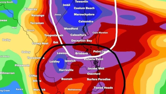
Brisbane is expected to see between 20mm to 40mm today, with up to 80mm possible tomorrow.
The Lockyer Valley is predicted to receive up to 30mm tomorrow.
It comes as the Bureau of Meteorology activates its flood watch alerts, with one covering an expansive area from Maryborough, south to Brisbane and to the New South Wales border.
The Bureau of Meteorology has activated flood watch for large parts of southeast Queensland.
“Persistent widespread showers, thunderstorms and rain areas are expected over southern inland catchments during Wednesday and Thursday, with locally heavy falls,” BOM warns.
“The weather will remain very unsettled towards the end of the week and into next week, with further significant rainfall possible over parts of the Flood Watch area.
Seqwater advises that its Flood Operations Centre is on ALERT due to possible heavy rainfall over the coming days. Seqwater will continue to monitor the situation and provide further updates. For more information https://t.co/6b9lv0fRo2 pic.twitter.com/vc2uYoqUv6
— Seqwater (@Seqwater) February 4, 2020
“The majority of catchments within the Flood Watch area have received rainfall over the last few weeks meaning rivers are more likely to respond to heavy rainfall.
“Riverine flooding is possible during Thursday over coastal catchments, whilst inland catchments are more likely to see riverine flooding later in the week.
“Localised flooding and minor disruption to transport routes is possible throughout the Flood Watch area.”
Significant rainfall ☔ totals last night between Noosa and Bundaberg with 141mm recorded at Mt. Elliot and 128mm at Coops Corner. Moderate rainfall expected to continue along the southeast coast, moving offshore and onto the Gold Coast tomorrow.
— Bureau of Meteorology, Queensland (@BOM_Qld) February 5, 2020
Forecast: https://t.co/84QfRx7d0U pic.twitter.com/qzhSTTpLSC
BOM forecaster Alex Majchrowski said areas of southeast Queensland could see up to 100mm in coming days.
“The Tweed, Noosa and Bundaberg could see quite a bit of rainfall today,” he said.
“At the moment in Noosa we’re predicting 40 to 80mm potentially and similar for Bundaberg as well.
“Tomorrow the focus shifts more offshore into the Gold Coast – so the Gold Coast will see some pretty decent falls tomorrow up to 100mm.
“And that starts to ease off on Friday but starts to pick up on the weekend but not as much as it has been.”
Mr Majchrowski said there is some potential for flash flooding.
“The focus shifts away from the north to the southeast coast itself and the west of the Darling Downs and parts of Maranoa Warrego districts,” he said.
“Around St George will get a fair bit over the next few days – they could get up to 50mm over the next few days.
“There’s some potential for some localised heavy flooding and flash flooding.”
Yesterday Mt Elliott and Coops Corner in the Wide Bay received 140mm and 128mm respectively.

Monster weather system brings storm, heavy rain to Qld
Brisbane and surrounding parts of the southeast have been hit by storms and heavy rainfall this afternoon as a 3000km-long monster low moves across the state.

Wild storms, polar blast as 3000km monster low barrels towards Qld
The system, which stretches 3000km from north to south and encompasses 30 per cent of Australia, is forecast to pack a punch when it hits Queensland.