
Queensland flood disaster timeline: Premier’s first warnings to thousands of homes flooded
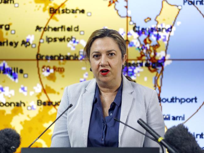
A timeline of South East Queensland’s flood disaster reveals how Premier Annastacia Palaszczuk and other officials were caught off guard by the sheer volume of rain and magnitude of flooding that caused havoc over three heartbreaking days.
QLD News
Don't miss out on the headlines from QLD News. Followed categories will be added to My News.
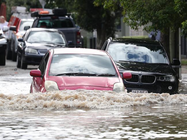
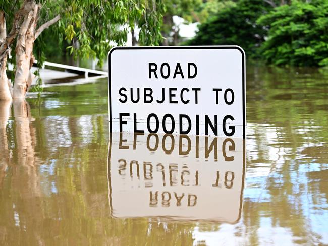
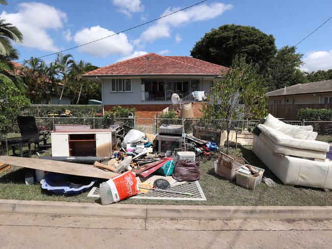
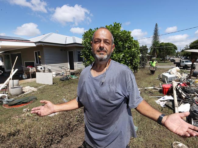
Thousands of homes flooded, 11 people died and lives were turned upside down during the major flood disaster that hit South East Queensland over three days this week.
This is a glimpse into how the disaster unfolded, from Premier Annastacia Palaszczuk’s first warning of anticipated heavy rain to the moments streets and homes started to flood.
TIMELINE OF FLOOD DISASTER
FEBRUARY 23
Premier Annastacia Palaszczuk tells parliament:
“Heavy rainfall is predicted to continue today and into Thursday. This has the potential to be a significant rainfall event for South East Queensland. Locally, intense rainfall is possible and since many catchments are now saturated, there is an increased risk of dangerous and life-threatening flash flooding over the coming days. … As the bureau has said, this can be a life-threatening weather event. I urge everyone in South East Queensland to exercise caution over the next 24 to 48 hours.”
FEBRUARY 24
Premier Annastacia Palaszczuk tells parliament:
“Thankfully, intense rainfall mostly remained off the South East coast overnight, but we have had a briefing this morning and the bureau does expect that rainfall to intensify and move into the South East later on today. A significant weather warning remains in place from: Maryborough to Coolangatta, and out west to Dalby and Stanthorpe. Intense rainfall is anticipated for many of these regions today. The heaviest rain, of course, is later today and early tomorrow. I am advised that moderate flood warnings are current for: the Mary River, the Stanley River and the upper Brisbane River.”
FEBRUARY 25
9am: Brisbane receives 64mm of rain in the 24 hours to 9am
11am: Health Minister Yvette D’Ath holds a press conference with Deputy Police Commissioner Steve Gollschewski and Deputy QFES Commissioner Mark Roche.
Mr Gollschewski says more intense rain is expected throughout the day and into tomorrow. He says local disaster management groups have been stood up, and that officials are “well prepared” for the weather event. He says: “We expect from the BOM briefing this morning that it will begin to ease into tomorrow. We’re still in a La Nina event. So we’re expecting elevated rainfall right through in the coming months. We expect this particular event to ease in the coming days.”
12pm: Premier Annastacia Palaszczuk speaks in Rockhampton to open a new art museum.
3.30pm: A press conference is held by the Bureau of Meteorology’s David Grant, QFES Commissioner Greg Leach, and Deputy Police Commissioner Steve Gollschewski.
Mr Grant says: “Areas of heavy rain are continuing across South East Queensland at the moment, and at this stage they’re expected to continue into the course of Saturday. … A number of flood warnings are now current across South East Queensland. … The number and severity of flood warnings is likely to increase during the course of today.”
Asked if flood prone areas such as Rocklea are likely to experience low-levels of inundation, Mr Grant says: “While heavy rain continues around the South East corner, yeah all low lying places around South East Queensland that are susceptible to flooding are highly likely to experience that over the next 12 to 24 hours. As I’ve said, many places have experienced heavy to locally intense rainfall, and around the South East corner – particularly around Brisbane, and westwards, we’re now experiencing some of the most intense falls that we may see during the course of this event.”
4.52pm: The Bureau of Meteorology posts a flood warning on Twitter for the Brisbane and Bremer Rivers. They warn of moderate flooding likely at Ipswich overnight, while minor flooding is likely at Brisbane City over the weekend.
FEBRUARY 26
9am: Brisbane receives 225.6mm of rain in the 24 hours to 9am
9am: Police Minister Mark Ryan holds a press conference with officials, including the Bureau of Meteorology’s David Grant.
Mr Grant says: “Areas of heavy rain are continuing across the South East and it’s likely this activity is now going to continue into Sunday with the system now moving slower than initially expected. … Numerous major flood warnings are now current across South East Queensland. And the number and the severity of these flood warnings is only going to increase over the course of this weekend and into early next week with further rainfall continued. … Minor flood warnings are expected at the Brisbane City gauge on the high tide over the course of the weekend. Of course it’s a bit early to tell with further rainfall about where the gauge may go to over the coming days, but we will definitely keep you updated on this as the event unfolds.”
1.45pm: Premier Annastacia Palaszczuk holds a press conference with officials, including the Bureau of Meteorology’s David Grant.
The Premier says officials had initially expected the rain event to ease about 4pm Saturday. “But we expect it to be here with us for at least the next 24 hours. So it does mean that we are monitoring very closely the river systems. We are monitoring Wivenhoe. … At this stage, we are not concerned because we are able to do the releases in a measured way. So please, I know this is of concern to many people who have experienced 2011. Please, there is no concern for alarm. … We can’t control nature unfortunately. Expectation was that this system would move quite quickly through. But it hasn’t. It’s decided to stay.”
Mr Grant says: “We’re seeing continued areas of heavy rain across the South East which are now likely to persist into the course of Sunday. As of this afternoon, at 2pm, we’re starting to see the heaviest rainfall probably now existing across Brisbane, extending into parts of Ipswich and parts of Redlands city council areas. … With many catchments now saturated, there is the potential for dangerous and life threatening flash flooding. … It must be emphasised that it is too early to call the flood peaks in some of our rivers, just due to the fact that it is still continuing to rain across much of our catchments around the area.”
Mr Grant said there was a major flood warning in place for parts of the Brisbane River.
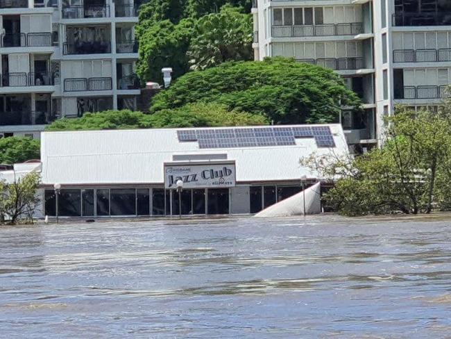
“Major flooding has now been recorded on the Bremer River at Ipswich, and minor flood peaks are also starting to occur at the Brisbane City, which did occur on the high tide today and will once again occur during the course of tomorrow. Again, with further rain, and tides being elevated and further waters coming in from our local creeks, we will see further rises on that Brisbane River. 2011 levels for both these catchments are still much higher, but again, rain is still falling across these catchments. Widespread moderate to major flooding is otherwise occurring across much of the remainder of the Brisbane River catchment.”
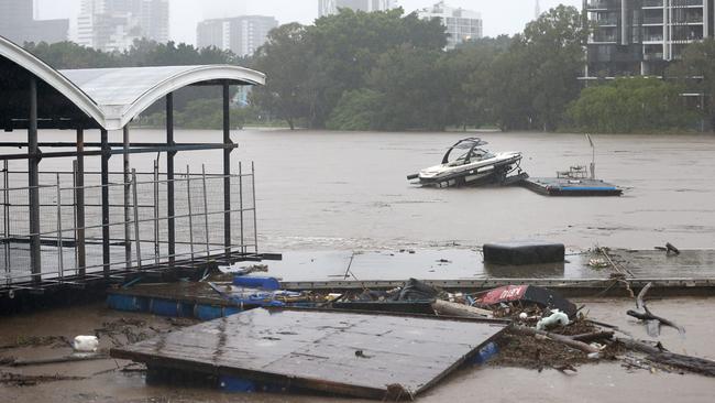
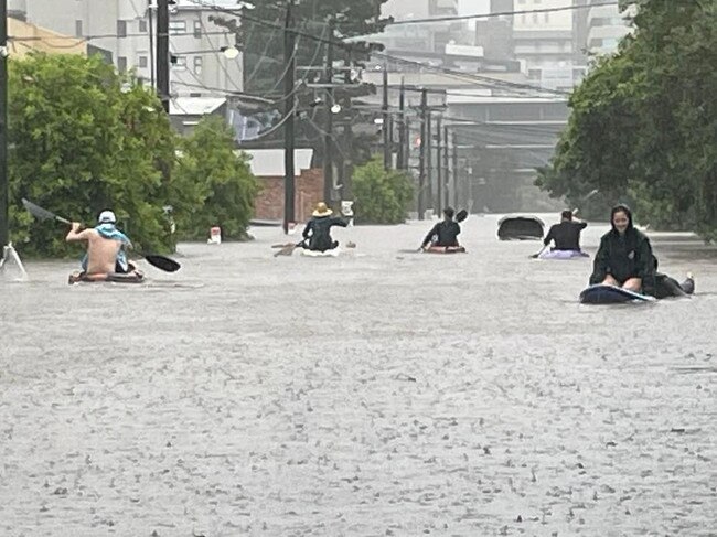
5.58pm: Brisbane Lord Mayor Adrian Schrinner says via Facebook that water could enter several thousand properties in suburbs including Brisbane City, Bulimba, Hamilton, Milton, New Farm, Newstead, Norman Park, Oxley, Rocklea, South Brisbane, St Lucia, Toowong, West End, and Yeronga.
FEBRUARY 27
9am: Brisbane receives 228.4mm of rain in the 24 hours to 9am
10am: Premier Annastacia Palaszczuk holds a press conference with officials, including the Bureau of Meteorology’s Laura Boekel and Brisbane Lord Mayor Adrian Schrinner.
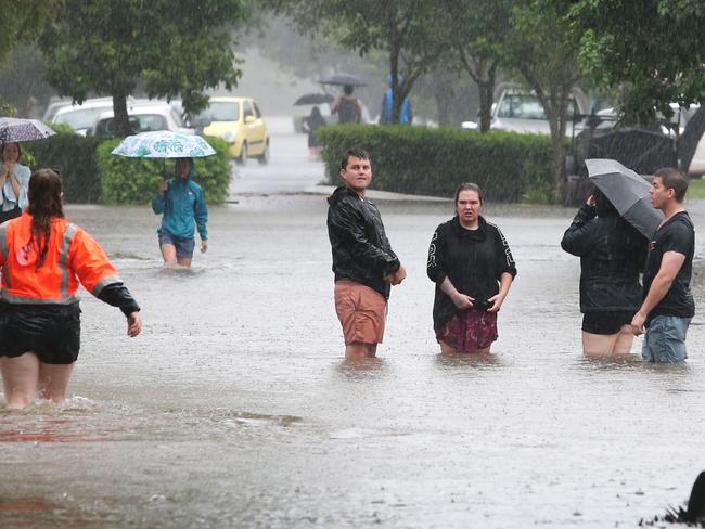
Ms Palaszczuk says: “In the Brisbane area and Ipswich, the areas that we are getting calls for assistance – so these are the people that need to be very careful about listening if there are any emergency alerts around Goodna, Rocklea, Oxley, Auchenflower, St Lucia, Yeronga, Beachmere, Caboolture, and Redcliffe. … The height that we are seeing now (in Brisbane) – I think we were predicting around 2.6m, 2.7m – it’s now at 3.1m. We expect that there may be 1,430 homes that will be impacted above the floorboards at this stage.”
Ms Boekel says: “We’re hoping to see some relief … earlier tomorrow. So the relief will come in the early hours of Monday morning but we can expect to see this rainfall event continue today and well into tonight as well. … We are continuing to update the Brisbane area. So at the moment, our warning has the moderate flood level. However, this is a very evolving situation and we really want people to stay on top of what those warnings are saying. We will be issuing updates today at 10am – we’ve issued one at 10am – 3pm and 9pm will be the next three issues for the Brisbane city. While we are expecting moderate flooding, as I said, it is an evolving situation and many things will contribute to the peaks that we see at the Brisbane River. That’s the observed rainfall, what rainfall we see today, and also what happens with the dams. So really enforcing that we want people to stay on top of those warnings and flood levels.”
Mr Schrinner says: “At the Brisbane gauge of the river monitoring levels, we’re seeing that there was a peak this morning of around 3.1m. In 2011, that peak at the same location was 4.46m. This has been defined as a moderate flood event, but it is still causing damage in many parts of Brisbane. … We have at least 24 hours more of danger. And that is something that people need to bear in mind. We had a high tide peak at 7am or 7.30am this morning. There will be another one around 7pm tonight. We will see another one at 8am tomorrow morning and then 8pm tomorrow night. So these are the critical times.”
3pm: Premier Annastacia Palaszczuk holds a press conference with officials, including the Bureau of Meteorology’s Laura Boekel.
Ms Palaszczuk says: “For the next 24 hours, we do expect the rain to be easing. But of course that doesn’t mean we’re out of the woods because we’re going to see these high levels for the next three days, especially around Bremer, the Brisbane River, and also down to the Logan, the Albert – and there could also be flash flooding as well. … Now what happens here is the local councils are responsible for issuing the emergency alerts. … No one expected this rain bomb to be sitting over the South East of our state for such a long period of time. Let me be very clear about this – this is like an unpredictable cyclone. It is the levels that we have never expected or could never have been forecast.”
Ms Boekel says: “So while we are seeing a contraction of this weather event further south and the focus still remains on Brisbane and Gold Coast, we have seen some isolated shower and storm activity about the Sunshine Coast. … So the forecast is still that we will continue to see this rainfall today and overnight, with some relief coming tomorrow as this systems contracts south.”
7pm: The Bureau of Meteorology issues a statement confirming it has upgraded its flood warning to major for the lower Brisbane River, around the CBD.
7.25pm: On Twitter, the Bureau of Meteorology confirms a major flood warning has been issued for Brisbane. BOM warns major levels are likely with the high tide on Monday morning and may reach 3.7m.
8.38pm: On Twitter, the Bureau of Meteorology confirms the Brisbane River in the city has just reached the major flood level on the high tide.
11.42pm: On Twitter, the Bureau of Meteorology says the Brisbane River in the city is now at 3.35m and falling. But they warn major levels are expected with the next high tide in the morning.
FEBRUARY 28
8.42am:Brisbane River in the city reaches its peak of 3.85m.
9am: Brisbane receives 222.8mm of rain in the 24 hours to 9am
10am: Premier Annastacia Palaszczuk holds a press conference with officials.
Ms Palaszczuk says: “Currently we have 1,544 people in evacuation centres across the South East. … In Brisbane, we’re estimating there could be up to 15,000 houses that are impacted. And as I said, we’re going to be monitoring very closely what happens during the rest of the day.”
MARCH 1
9am: Brisbane receives 5.6mm of rain in the 24 hours to 9am
10am: Another flood peak of 3.35m occurs on the Brisbane River.
10.35am: Premier Annastacia Palaszczuk holds a press conference with officials.
Ms Palaszczuk says: “The rain event that Brisbane had over that two to three day period in total is equivalent to 80 per cent of the rainfall that we would receive in one year. … And we have over 30 suburbs across the South East that received over 1000mm. … We believe that it (the river) has stabilised and is starting to fall, but we do expect the river to remain around that 3.5m mark, or a little bit lower, over the next few days as they continue now the staged releases from Wivenhoe.”
MARCH 2
9am: Brisbane receives 0.2mm of rain in the 24 hours to 9am
12.20pm: Premier Annastacia Palaszczuk holds a press conference in Gympie.
MARCH 3
9am: Brisbane receives 56mm of rain in the 24 hours to 9am
11am: Premier Annastacia Palaszczuk holds a press conference with officials.
Ms Palaszczuk says: “We’ve just been updated from the bureau and … there are severe conditions that are going to be experienced from the north of Brisbane in that northern Moreton Bay region, Sunshine Coast, Gympie, Wide Bay, all the way up to Bundaberg. This is of serious concern. So what we are asking people to do who live in this region, we are asking people to in the first instance, children are safe at school. But you should collect your children when it is safe to do so. We are warning people that this is a serious situation. It is extremely unstable weather conditions.
“The conditions are going to be unstable for the next 24 to 48 hours. So across the entire South East, I’m asking people tomorrow to think about not being on the roads and staying at home. The schools will open for children of essential workers. But under all the information that has been given to me this morning – to myself, the commissioner, the acting state disaster co-ordinator, and the Deputy Premier – this is the action that we wish to take. Everyone, please listen to the alerts. It’s a serious situation. These are unprecedented times.”
MARCH 4
9am: Brisbane receives 0.6mm of rain in the 24 hours to 9am
10am: Premier Annastacia Palaszczuk holds a press conference with officials.
Ms Palaszczuk says: “Can I say to all of the parents in the South East that I apologise for the inconvenience, but I think everybody would realise if you’re in my shoes and you were given the advice that was given to us yesterday, I think everyone would have taken exactly the same decision. But I do acknowledge there has been some inconvenience today for parents. But safety has to come first.”
March 5
9am: Brisbane receives 0mm of rain in the 24 hours to 9am.

Inside US Navy’s largest missile sub during Brisbane visit
USS Ohio's sailors are breathing fresh air in Brisbane after joining the Talisman Sabre military exercise, as a rare tour reveals life inside America's most heavily-armed submarine. PICTURES

Family determined to give dying child ‘end of life’ bucket list
A Queensland family has vowed to give their terminally ill boy as many adventures as possible and will do all they can to help him make it to his birthday in just a few weeks.