
Cyclone Kirrily safety guide: forecast, cyclone track map & road closures
Cyclone Kirrily has been upgraded to a Category 3 cyclone. Here is everything you need to know and the latest warnings and advice from the Bureau of Meteorology, including school closures.
Emergency Services
Don't miss out on the headlines from Emergency Services. Followed categories will be added to My News.
Cyclone Kirrily is set to cross the coast near Townsville tonight. We’ve listed everything you need to know to prepare for the cyclone and the latest warnings and advice from the Bureau of Meteorology.
Jump to:Cyclone forecast | Track map | Road closures | Places in danger | Evacuation orders | Safety routes | How to stay safe | Cyclone categories
CYCLONE FORECAST
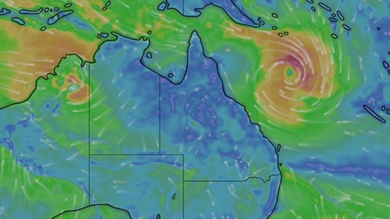
Issued at 4:56 pm EST on Thursday 25 January 2024
Intensity: Category 3, sustained winds near the centre of 120 kilometres per hour with wind gusts to 165 kilometres per hour.
Location: within 30 kilometres of 18.8 degrees South 147.4 degrees East, estimated to be 85 kilometres northeast of Townsville and 320 kilometres northwest of Mackay.
Movement: west southwest at 25 kilometres per hour.
Townsville residents ordered to stay indoors as Cyclone Kirrily impacts north Queensland
Qld weather: Tropical cyclone Kirrily weakens, 64,000 properties without power
400mm deluge, dangerous storm surge: TC Kirrily barrels towards Qld
Tropical Cyclone Kirrily expected to form overnight, make landfall Thursday night
Severe Tropical Cyclone Kirrily is expected to track west southwest towards the Queensland coast. Kirrily will cross the Queensland coast tonight, in the vicinity of Townsville, as a Category 3 system then weaken on Friday as it moves inland.From Friday, Kirrily is likely to track further inland as a tropical low, resulting in heavy to intense rain to parts of the northern interior and western Queensland.
CYCLONE TRACK MAP
Keep up to date with the cyclone’s movements here.
ROAD CLOSURES AND PREPARATIONS
As of 6.30pm Thursday.
Georgetown / Minnamoolka
Georgetown and 40 Mile Scrub
Heavy rain
Road closed to all traffic
All directions
Long delays expected
Do not drive in flood waters
Burke Developmental Road
Gamboola
Lynd River
Heavy rain
Road closed to all traffic
All directions
Long delays expected
Do not drive in flood waters
Burke Developmental Road
Wrotham
Walsh River (Trimble’s Crossing)
Water over road
Road closed to all traffic
Both directions
Long delays expected
Do not drive in flood waters
Burke Developmental Road
Rookwood
Fergusons Crossing
Water over road
Road closed to all traffic
Both directions
Long delays expected
Do not drive in flood waters
Peninsula Developmental Road (Archer River Bridge)
Coen
Archer River Bridge
Water over road
Road closed to all traffic
Both directions
Delays expected
Do not drive in flood waters
Peninsula Developmental Road (Laura River Bridge)
Laura
CLOSED - Laura River Bridge
Water over road
Road closed to all traffic
All directions
Long delays expected
Do not drive in flood waters
Gulf Developmental Road
Samwell Street
Blackbull / Croydon
ROAD OPEN WITH CAUTION - Croydon to Croydon Shire Council Boundary
Water over road
All lanes affected
Both directions
Do not drive in flood waters
Water over the road at floodways
Peninsula Developmental Road
Laura
CLOSED at Hann River Bridge
Water over road
Road closed to all traffic
Both directions
Do not drive in flood waters
Gregory Developmental Road
Einasleigh / Mount Surprise
Einalseigh to Gulf Developmental Rd.
Heavy rain
Road closed to all traffic
Both directions
Long delays expected
Do not drive in flood waters
Einasleigh River Flooded
Koolatah Oriners Road
Dixie / Maramie
Koolatah to Oriners
Heavy rain
Road closed to all traffic
All directions
Long delays expected
Do not drive in flood waters
First Street
North Street
Forsayth / Georgetown
ROAD OPEN WITH CAUTION - Georgetown to Forsayth
Water over road
All lanes affected
All directions
Diversions are in place
Water over road in multiple locations, gravel sections slippery
Hawkins Creek Road
Dalrymple Creek
Dalrymple Bridge
Heavy rain
Road closed to all traffic
Both directions Delays expected
Do not drive in flood waters
Newtons Crossing Road
Peacock Siding
Road Closed
Heavy rain
Road closed to all traffic
Long delays expected
Do not drive in flood waters
Sand and SES supplied bags are available at seven sites across Townsville:
Ross Dam car park, Upper Ross, behind the Parks compound
Lou Litster Park, behind Officeworks at Hermit Park
The carpark at the Local Disaster Coordination Centre Dalrymple Road Depot
Corner of Bruce Highway & Mt Low Parkway
Bluewater SES Depot
Rupertswood Rural Fire Shed (14 Progress Rd, Alice River)
Cungulla Community Centre
SCHOOL CLOSURES
State school closures:
* Abergowrie State School
5 Venables Road, Abergowrie, 4850
* Airville State School
920 Old Clare Road, Airville, 4807
* Aitkenvale State School
67-85 Wotton Street, Aitkenvale, 4814
* Annandale State School
Cnr Oleander Street & Yolanda Drive, Annandale, 4814
* Ayr State High School
Cnr Edwards & Wickham Streets, Ayr, 4807
* Ayr State School
141 Graham Street, Ayr, 4807
* Belgian Gardens State School
43 Potts Street, Belgian Gardens, 4810
* Bluewater State School
Buckby Street, Bluewater, 4818
* Bohlevale State School
Bohlevale School Road, Burdell, 4818
* Bowen State High School
1-9 Argyle Park Road, Bowen, 4805
* Bowen State School
29 Kennedy Street, Bowen, 4805
* Brandon State School
Drysdale Street, Brandon, 4808
* Burdekin School
159 Young Street, Ayr, 4807
* Bwgcolman Community School
Creek Road, Palm Island, 4816
* Cannonvale State School
56 Coral Esplanade, Cannonvale, 4802
* Clare State School
Larkin Street, Clare, 4807
* Cleveland Education and Training Centre
Old Common Road, Rowes Bay, 4810
* Collinsville State High School
Walker Street, Collinsville, 4804
* Collinsville State School
Devlin Street, Collinsville, 4804
* Cranbrook State School
Alice Street, Cranbrook, 4814
* Currajong State School
140 Palmerston Street, Gulliver, 4812
* East Ayr State School
43-73 Ross Street, Ayr, 4807
* Forrest Beach State School
40 Pandanus Street, Forrest Beach, 4850
* Garbutt State School
76 Chandler Street, Garbutt, 4814
* Giru State School
45-51 Luxton Street, Giru, 4809
* Gumlu State School
De Salis Street, Gumlu, 4805
* Halifax State School
17 Victoria Terrace, Halifax, 4850
* Hamilton Island State School
Hamilton Island, Whitsundays, 4803
* Hayman Island State School
Hayman Island, Whitsundays, 4802
* Heatley Secondary College
Cnr Hanlon Street & Fulham Road, Heatley, 4814
* Heatley State School
410 Fulham Road, Heatley, 4814
* Hermit Park State School
Cnr Surrey & Sussex Streets, Hyde Park, 4812
* Home Hill State High School
First Street, Home Hill, 4806
* Home Hill State School
113 Fourteenth Avenue, Home Hill, 4806
* Ingham State High School
12 Menzies Street, Ingham, 4850
* Ingham State School
28 McIlwraith Street, Ingham, 4850
* Jarvisfield State School
Rita Island Road, Jarvisfield, 4807
* Kalamia State School
Lilliesmere Road, Brandon, 4808
* Kelso State School
Yvette Street, Kelso, 4815
* Kirwan State High School
Hudson Street, Kirwan, 4817
* Kirwan State School
21 Burnda Street, Kirwan, 4817
* Macknade State School
79 Farrell Drive, Macknade, 4850
* Magnetic Island State School
10-16 Mandalay Avenue, Nelly Bay, 4819
* Maidavale State School
Maidavale Road, Airville, 4807
* Merinda State School
Bergl Street, Bowen, 4805
* Millaroo State School
Cunningham Street, Millaroo, 4807
* Mount Fox State School
2957 Mt Fox Road, Mount Fox, 4850
* Mundingburra State School
77 Ross River Road, Mundingburra, 4812
* Mutarnee State School
School Road, Mutarnee, 4816
* North Shore State School
9 Langford Street, Burdell, 4818
* Northern Beaches State High School
Meranti Street, Deeragun, 4818
* Oonoonba State School
Fairfield Waters Drive, Idalia, 4811
* Osborne State School
Kirknie Road, Osborne, 4806
* Paluma Environmental Education Centre
53 Mt Spec Road, Paluma, 4816
* Pimlico State High School
Fulham Road, Gulliver, 4812
* Proserpine State High School
4 Ruge Street, Proserpine, 4800
* Proserpine State School
33 Renwick Road, Proserpine, 4800
* Queens Beach State School
39 Tracey Street, Bowen, 4805
* Queensland Pathways State College - Townsville Campus
1B Core Street, Gulliver, 4812
* Railway Estate State School
39 Railway Avenue, Railway Estate, 4810
* Rasmussen State School
Allambie Lane, Rasmussen, 4815
* Rollingstone State School
Fred Williams Drive, Rollingstone, 4816
* Scottville State School
21 Eleventh Avenue, Scottville, 4804
* The Willows State School
Bilberry Street, Kirwan, 4817
* Thuringowa State High School
26 - 54 Vickers Road South, Condon, 4815
* Toobanna State School
Bruce Highway, Toobanna, 4850
* Townsville Central State School
4 Warburton Street, North Ward, 4810
* Townsville Community Learning Centre - A State Special School
78 Thompson Street, Mundingburra, 4812
* Townsville South State School
78 Tully Street, South Townsville, 4810
* Townsville State High School
36 Boundary Street, Railway Estate, 4810
* Townsville West State School
Wilson Street, West End, 4810
* Trebonne State School
71 Stone River Road, Trebonne, 4850
* Victoria Plantation State School
244 Forrest Beach Road, Victoria Plantation, 4850
* Vincent State School
280 Palmerston Street, Vincent, 4814
* Weir State School
592 Ross River Road, Thuringowa Central, 4817
* William Ross State High School
Mervyn Crossman Drive, Annandale, 4814
* Woodstock State School
Woodstock Avenue, Woodstock, 4816
* Wulguru State School
Edison Street, Wulguru, 4811
Independent school closures:
* Annandale Christian College (Annandale)
104-156 Yolanda Drive, Annandale, 4814
* Burdekin Christian College (Melbourne St - Ayr)
2-12 Melbourne Street, Ayr, 4807
* Calvary Christian College (Mount Louisa)
569 Bayswater Road, Mount Louisa, 4814
* Carinity Education - Shalom (Condon)
190 Hervey Range Road, Condon, 4815
* Eaton College (Mount Louisa)
593 - 615 Bayswater Road, Mount Louisa, 4814
* Enkindle Village School (Douglas)
James Cook Drive, Douglas, 4814
* Hinchinbrook Christian School (Ingham)
77 Halifax Road, Ingham, 4850
* Indie School, Logan (Thuringowa Central)
86 Thuringowa Drive, Thuringowa Central, 4817
* Kutta Mulla Gorinna Special Assistance School (Mackay)
133 Alfred Street, Mackay, 4740
* Mungalla Silver Lining School (Mutarnee)
Spiegelhauer Road, Mutarnee, 4816
* Riverside Adventist School (Aitkenvale)
59 Leopold Street, Aitkenvale, 4814
* Silver Lining School (Cluden)
16 Jurekey Street, Cluden, 4811
* Tec-NQ (Douglas)
54 Discovery Drive, Douglas, 4814
* The Cathedral School of St Anne and St James (Mundingburra)
154 Ross River Road, Mundingburra, 4812
* Townsville Christian College (Vincent)
210 Palmerston Street, Vincent, 4814
* Townsville Grammar School (Annandale)
1 Brazier Drive, Annandale, 4814
* Townsville Grammar School (Burdell)
Cnr Erskine Place & North Shore Boulevard, Burdell, 4818
* Townsville Grammar School (North Ward)
45 Paxton Street, North Ward, 4810
Catholic school closures:
* Burdekin Catholic High School (Ayr)
45 Gibson Street, Ayr, 4807
* Gilroy Santa Maria College (Ingham)
17 Chamberlain Street, Ingham, 4850
* Good Shepherd Catholic School (Rasmussen)
65 Allambie Lane, Rasmussen, 4815
* Holy Spirit Catholic School (Cranbrook)
Hatchett Street, Cranbrook, 4814
* Ignatius Park College (Cranbrook)
368-384 Ross River Road, Cranbrook, 4814
* Marian Catholic School (Currajong)
198 - 208 Hugh Street, Currajong, 4812
* Our Lady of Lourdes Catholic School (Ingham)
18 Abbott Street, Ingham, 4850
* Ryan Catholic College (Kirwan)
59 Canterbury Road, Kirwan, 4817
* Southern Cross Catholic College (Townsville)
Gartrell Drive, Annandale, 4814
* St Anthony’s Catholic College (Veales Rd - Deeragun)
Veales Road, Deeragun, 4818
* St Anthony’s Catholic College (Veales Rd and Joanne St - Deeragun)
Cnr Veales Road and Joanne Street, Deeragun, 4818
* St Augustine’s School (Mossman)
Grogan Street, Mossman, 4873
* St Benedict’s Catholic School (Shaw)
890 Dalrymple Road, Shaw, 4818
* St Catherine’s Catholic College The Whitsundays (Proserpine)
96-114 Renwick Road, Proserpine, 4800
* St Clare’s Catholic School (Burdell)
Burdell Drive, Burdell, 4818
* St Colman’s Catholic School (Home Hill)
Eleventh Avenue, Home Hill, 4806
* St Francis Catholic School (Ayr)
99 Edwards Street, Ayr, 4807
* St John Bosco Catholic School (Collinsville)
25 Blake Street, Collinsville, 4804
* St Joseph’s Catholic School, The Strand (North Ward)
Fryer Street, North Ward, 4810
* St Joseph’s School (Mundingburra)
65-75 Ross River Road, Mundingburra, 4812
* St Margaret Mary’s College (Hyde Park)
1-9 Crowle Street, Hyde Park, 4812
* St Mary’s Catholic School (Bowen)
39 Poole Street, Bowen, 4805
* St Michael’s Catholic School (Palm Island)
Banfield Highway, Palm Island, 4816
* St Patrick’s College Townsville (Townsville)
45 The Strand, Townsville, 4810
* St Peter’s Catholic School (Halifax)
15-17 Anderssen Street, Halifax, 4850
* St Teresa’s College (Abergowrie)
3819 Abergowrie Road, Abergowrie, 4850
* Townsville Flexible Learning Centre (Cunningham St - Ayr)
1-45 Cunningham Street, Ayr, 4807
* Townsville Flexible Learning Centre (West End, Townsville)
26 Ingham Road, West End, Townsville, 4810
For child care centres please check the ACECQA website.
For emergency assistance call the Queensland State Emergency Service (SES) onupda 132 500 (for assistance with storm damage, rising flood water, fallen trees on buildings or roof damage).

FULL LIST OF PLACES IN CYCLONE KIRRILY’S PATH
People between Ingham and Bowen, including Townsville and Ayr should complete preparations quickly and be prepared to shelter in a safe place.
- Boats and outside property should be secured using available daylight hours.
- For cyclone preparedness and safety advice, visit Queensland’s Disaster Management Services website (www.disaster.qld.gov.au)
- For emergency assistance call the Queensland State Emergency Service (SES) on 132 500 (for assistance with storm damage, rising flood water, fallen trees on buildings or roof damage).
- If you choose to take shelter away from your home, stay COVID-19 safe and pack a mask and hand sanitiser (if you have them).
People between Innisfail and Ingham and between Bowen and Sarina, including Bowen, Mackay, and the Whitsunday Islands, should immediately commence or continue preparations, especially securing boats and property using available daylight hours.
People in inland areas to Charters Towers should take precautions and listen to the next advice.
LOCATIONS UNDER THREAT, FACING WARNINGS AND EVACUATION ORDERS
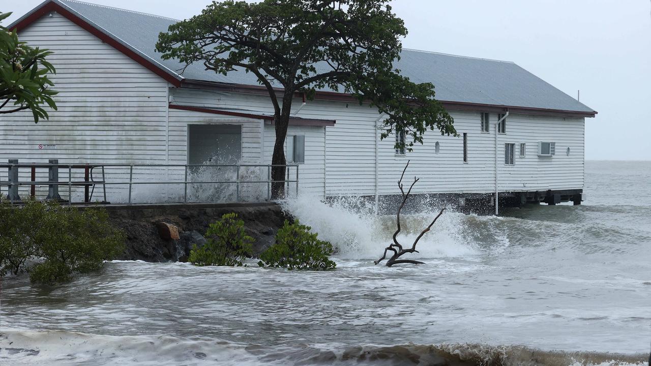
GALES with DAMAGING WIND GUSTS to 120 km/h are occurring over the Whitsunday Islands and are expected to extend to mainland communities between Ayr and Sarina later today.
GALES with DAMAGING WIND GUSTS to 120 km/h are expected to extend northward to coastal and island communities between Ayr and Ingham, including Townsville, later this afternoon and evening and may extend north between Ingham to Innisfail if the system takes a track further north.
DESTRUCTIVE WIND GUSTS to 155 km/h may develop about coastal and island communities between Ayr and Bowen, during this evening extending north to Ingham, including Townsville tonight.
VERY DESTRUCTIVE WIND GUSTS to 170 km/hr may occur near the centre as Kirrily crosses the coast.
GALES with DAMAGING WIND GUSTS to 90 km/h are expected to extend to inland areas including Charters Towers overnight tonight into Friday morning.
HEAVY RAINFALL which may lead to FLASH FLOODING is likely to develop about coastal areas and nearby inland between Tully and Bowen during this afternoon before spreading further inland this evening and Friday.
INTENSE RAINFALL which may lead to DANGEROUS AND LIFE THREATENING FLASH FLOODING is possible near the track of the system. A flood watch is also current for these areas.
During Friday, the system is expected to become a tropical low and HEAVY RAINFALL may develop across the northern interior and western Queensland into the weekend as the system tracks inland.
As the system approaches and crosses the coast, a STORM TIDE is expected between Townsville and Mackay. Large waves may produce minor flooding along the foreshore. People living in areas likely to be affected by this flooding should take measures to protect their property as much as possible and be prepared to help their neighbours.
EVACUATION CENTRES AND SAFETY ROUTES
Evacuation centres:
Heatley Secondary College, 321 Fulham Road, Heatley Queensland 4814
Wills Street Evacuation Centre, Townsville City, QLD 4818
Place of refuge:
143-201 Walker St, Townsville QLD 4810, Australia
Qld weather: La Nina predicted to make return in 2024
Flood camera locations:
Allambie Lane
Mount Low - Bridge Overview
HOW TO STAY SAFE DURING THE CYCLONE
To prepare for Cyclone Kirrily you should:
• Check your property for any loose material
• Fill vehicles fuel tanks
• Fill water containers as fresh drinking water may not be available after impact
• Ensure you have an emergency kit on hand
• Make sure household members are aware of where the strongest part of the home is
• Check on your neighbours to make sure they are prepared
• Keep a list of emergency phone numbers on display
• Withdraw a small amount of cash from the ATM as electronic banking may not be available after impact
• Park your vehicle under solid shelter
• Remain indoors unless asked to evacuate
• Pack any essential medications, baby formula, nappies or spare clothes
• Place all important documents and photographs in waterproof bags
• Ensure you have canned food and a can opener
• Make sure you have a portable radio and backup batteries
Category 5 cyclones: What the wind, rain and noise is really like
Keep pets safe during a cyclone by keeping them indoors with you. Make sure you have them in a carry cage, or they are on a leash. If you have birds they can be transported in a pillowcase in an emergency as long as the pillowcase has a low thread count.
Qld storms: Anthony Albanese promises more cash during Gold Coast visit
If you are asked to evacuate do not return to your home until it is safe to do so, or if you are sheltering in-place, stay indoors until you have been told it is safe to go outside. Don’t enter floodwaters and don’t use any electric appliances if they are wet.
Jump to:Cyclone forecast | Track map | Road closures | Places in danger | Evacuation orders | Safety routes | How to stay safe | Cyclone categories
WHAT ARE THE CYCLONE CATEGORIES?
Category: 1 – Tropical Cyclone
Strongest gust: Less than 125 km/h. Gales
Typical effects: Minimal house damage. Damage to some crops, trees and caravans. Boats may drag moorings.
Category: 2 – Tropical Cyclone
Strongest gust: 126-164 km/h. Destructive winds
Typical effects: Minor house damage. Significant damage to signs, trees and caravans. Heavy damage to some crops. Risk of power failure. Small boats may break moorings.
Category: 3 – Severe Tropical Cyclone
Strongest gust: 165-224 km/h. Very destructive winds
Typical effects: Some roof and structural damage. Some caravans destroyed. Power failure likely.
Category: 4 – Severe Tropical Cyclone
Strongest gust: 225-279 km/h. Very destructive winds
Typical effects: Significant roofing and structural damage. Many caravans destroyed and blown away. Dangerous airborne debris. Widespread power failures.
Category: 5 – Severe Tropical Cyclone
Strongest gust: More than 280 km/h. Extremely destructive winds

Woman killed, kids injured in horror railway crash
A woman has died and two children have been injured after their car crashed and came to a stop on a railway line on the Bruce Highway.

Neighbour shares worrying detail after 4yo’s devastating fall
A neighbour has revealed safety concerns in the weeks leading up to the serious fall of a four-year-old boy off a balcony on the Sunshine Coast.