
Qld weather: Tropical cyclone Kirrily weakens, 64,000 properties without power
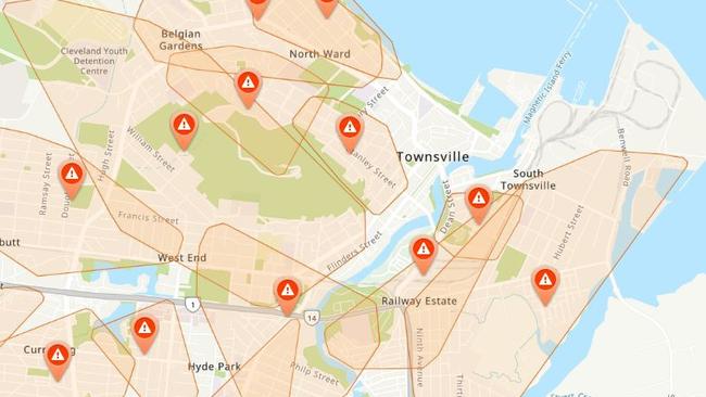
North Queenslanders could face week-long power outages, as more than 60,000 properties remain blacked out, and Townsville residents have been urged to conserve water after ex-tropical cyclone Kirrily crossed the coast.
QLD weather news
Don't miss out on the headlines from QLD weather news. Followed categories will be added to My News.
North Queensland residents affected by power outages in the wake of Tropical Cyclone Kirrily could be forced to wait up to seven days before power is restored to their homes.
More than 60,000 residents between south Ingham to Home Hill remain without power, the majority (55,000) in Townsville.
A warning has also been issued for residents in the Townsville area to conserve water, with power outages affecting water sites.
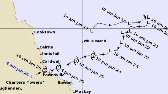
The cyclone, which has now weakened to a tropical low and is moving west, hit near Townsville about 10pm, bringing destructive winds and widespread power outages.
“The coastal crossing itself happened just to the north of Townsville. We did see some moderate falls across the region with the system moving through as well,” Bureau of Meteorology forecaster Miriam Bradley said.

“The top total being 176mm at Paluma, which is just to the north of Townsville, but the winds were certainly significant with this system.
“We saw 143 kilometres an hour at Flinders Reef which was our highest wind gust observed.
“On the mainland, the highest gusts were 107km/h at Alva Beach and around Townsville we saw gusts above 90km/h.”
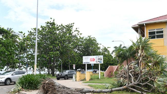
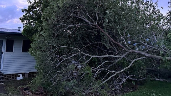
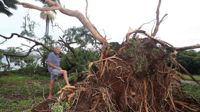
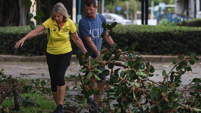
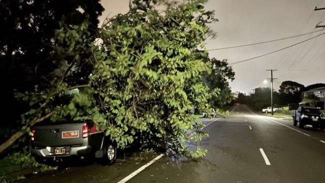
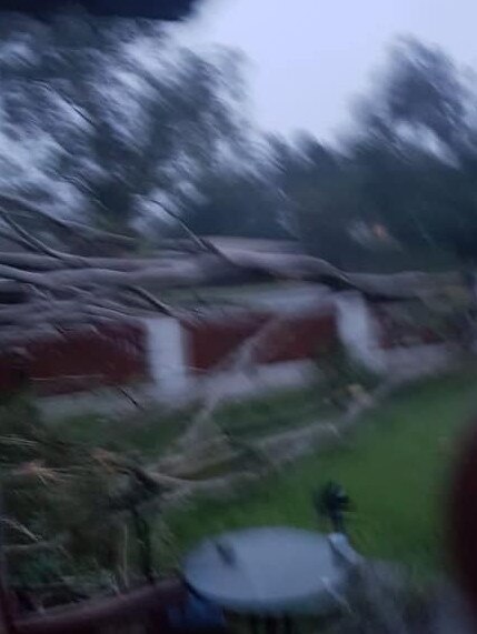
In Townsville and surrounding communities, power lines were downed and branches ripped from trees in gale force winds.
At a media conference in Brisbane this morning, Premier Steven Miles said it had been a tense night in north Queensland, but there was relief the storm had passed with no lives lost.
“There has been minimal property damage; the biggest impact at this stage is on the energy network,” he said.
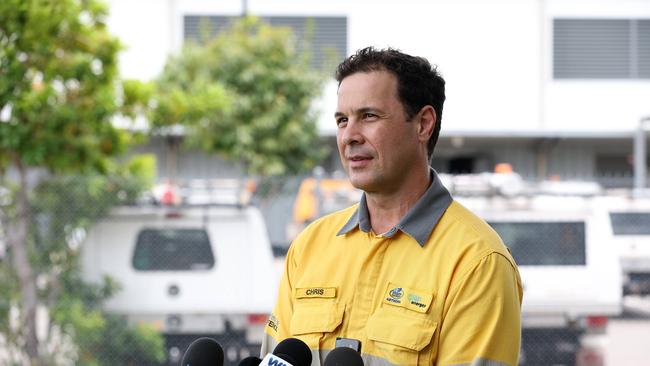
Chris Hooper, who will head the Ergon response teams, said crews were still assessing damage on Friday afternoon, with a detailed restoration plan likely available within 48 hours.
Mr Hooper said it was hard to estimate how many days residents could be waiting for power restoration until the plan was complete.
“But I’d say days, out to about seven days at this point in time,’ he said.
“There’s a lot of leafage, a lot of vegetation over powerlines.
“Once we have a better feel for how much damage is out there, we’ll have a better feel for the restoration plan.
“We will expect prolonged outages in some rural areas outside of the (Townsville) CBD.”
About 100 local Ergon staff were on the ground on Friday, with another 600 arriving from around the state on Saturday to assist with restoration.
Those who currently have power have been warned they may experience outages in coming days as crews identify further damage and conduct makesafes.
■ All your key power outage questions answered
Mr Hooper assured residents that crews were working quickly and reminded them to report all outages so they could be added to the restoration plan.
“It’s an interesting one because a lot of customers walk out outside of their house and they look around and there’s not a lot of damage that’s visible,” he said.
“Some of our feeders go for kilometres and span through many suburbs, so just because the damage is in their area doesn’t mean that we haven’t got damage to respond to.
“I just want to reassure that if there is damage to the network that our customers actually report that it helps us restore power quicker because we can actually get trucks to them.”
With minimal rainfall forecast and help on the way, Mr Hooper is confident supply will be returned “quite quickly”.
“Thankfully, it’s a little bit dissimilar to Jasper because we don’t have the flooding that comes behind it, which gives us our best position to respond” he said.
“Over 600 resources will be on the ground over the coming days so we’ll hopefully progressively restore the supply quite quickly.”
Energy Minister Mick de Brenni said there was a lot of damage on the local distribution network but the transmission network was in tact.
“Crews are out on the ground this morning and more help is on the way. Those crews that we pre deployed into places like Rockhampton are on the road right now,” he said.
Mr de Brenni said while there were 64,000 households without power at rthe time he addressed media in the morning, that number was likely to increase as crews assessed damage and found more vegetation on trees.
“This will be a bit of a marathon, not so much a sprint, they will be working hard around the clock as they have done in the previous events,” he said.
“Just to put it into context, following the Christmas Day storms, it took about two days for us to assess the damage enough to be able to release that restoration plan.”
QFES acting commissioner Stephen Smith said there were a limited number of calls overnight with 215 received in the 24 hours to 8am.
Minister for Fire and Disaster Recovery Nikki Boyd said it was one of the larger population bases they had seen in recent history for cyclones.
“In terms of the Reconstruction Authority, we’ve got counter disaster operations that I’ll be seeking funding applications for today for the local government areas of Hinchinbrook, Palm Island, Townsville and Burdekin,” she said.
“Those are funds that can assist the local governments in those areas with the disaster preparedness as well as any costs that they incur in the clean-up from this event and make it safe after the event.”
Minister for Emergency Management Murray Watt said from a federal perspective there were a number of resources available and still on standby.
“We’ve put ADF personnel and helicopters that are based in Townsville on standby as yet they have not been required to assist but they remain available to Queensland should they be required,” he said.
“The early indications seem to be that this event is going to be able to manage within the capacity of the state government. “
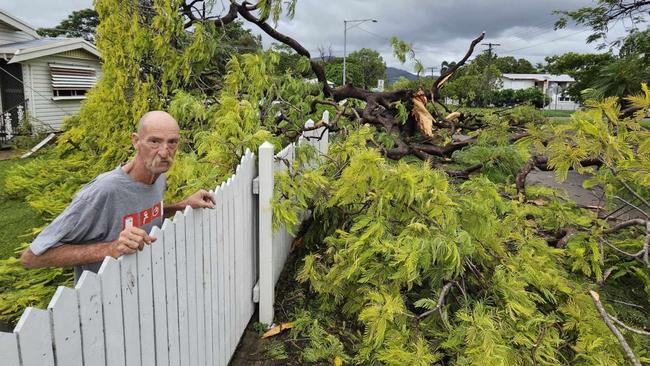
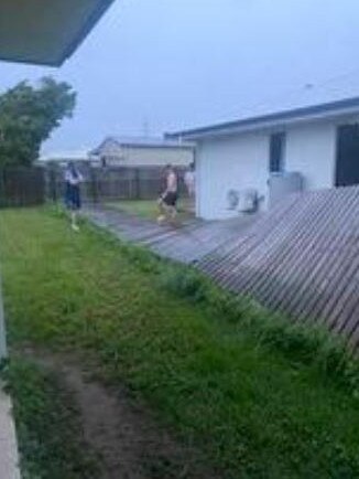
Clean-up efforts across the city are now in full swing, with trees down on cars and powerlines and near homes.
Clearing the roads of debris was the main priority early this morning, with one man seen using ratchet straps to tow a fallen tree off the road with his car.
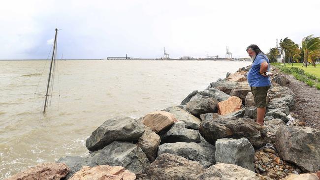
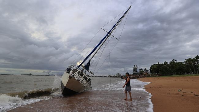
At least three boats have washed ashore in Townsville after breaking free from the Breakwater Marina overnight, with reports one has sunk.
A 30ft yacht was found tightly wedged on the sandbank at Pallarenda, mast tilted towards the ground.
Owner Pete Bright said he was lucky to find the huge boat washed up on sand instead of rocks, incredibly undamaged.
“Nah she’s solid,” he said. “It was lucky it would have come off when the winds were southerly. I’d prefer it here than over on the rocks.”
Mr Bright will now camp out to protect the boat from looters as he waits for high tide to drag the huge vessel off the sand.
“Boat’s fine, just a matter of no one pilfering it now,” he said.
“I’ll try to get it back in the water but it’s not going to happen for a couple of days.
“Maybe if I’m really lucky tomorrow night, really lucky.”
Tourists at the Tasman Holiday Park in Rowes Bay were kept awake all night by the sound of trees uprooting and snapping in half.
Five minutes away in West End, Dave Nougent pulled out his chainsaw to start stripping a huge fallen tree which landed right at the doorstep of his daughter’s newly renovated home.
Down by the marina, boat owners arrived to check their vessels.
Douglas Bremner said he was contacted by police around 6.30am with the message that his 25ft vessel had smashed into a rockfall around midnight.
“They wanted to see if I was on-board,” he said. “A few of those boats out there had people stay on board overnight.
“I didn’t think it would be this bad, I thought it would go around the cape and we’d be protected but as soon as it went over Palm Island, its wide open here, came straight at us.
“There were gales after midnight.”
The concern now is for communities further west, with potential monsoon conditions in coming days.
A severe weather warning remains in place for much of north Queensland as the system tracks west of Townsville, with intense rainfall and flash flooding still possible.
The system is now tracking inland, with heavy to locally intense rainfall and damaging winds expected across the northern interior and western Queensland into the weekend.
At 4am, the low was located approximately 170km southwest of Townsville, moving west southwest at 24km an hour. The Bureau says it will continue travelling southwest across the state before tracking into the Northern Territory.
“The expectation for the rest of today is that this system will move southwest across the northern interior of Queensland,” Ms Bradbury said.
“It may generate areas of heavy rainfall and flash flooding and possible damaging winds as well.
“As a result, we do still have a severe weather warning current, which covers large parts of coastal adjacent areas from between Tully and Townsville and then pushing inland across those northern inland parts.
“We anticipate river rises over the coming hours and possibly days as rainfall from this system moves through those waterways and may trigger some riverine flooding.
“I should also mention, we still have most parts of northern and inland Queensland covered by flood watches. So the impacts and the risks still continue. Even now the system has been downgraded to a tropical low.”
Bureau records show 102mm fell in Mt Garnett in six hours overnight, 105mm at Crooks Dam, and 101mm was recorded in three hours at Michael Creek.
Ergon Energy on Thursday said it would use the recent Cyclone Jasper as a guide to determine how many households could lose power over the coming days, with Townsville’s area manager Katrina Lennon revealing they had 50,000 customer experience blackouts in the previous weather event.
“We have had a rest since Jasper which gives us confirmation that we’re ready to respond, we know what we’re doing and we have a lot of veterans in the game,” she said.
“If we look at the impact of Cyclone Jasper, we had up to 50,000 customers go out.”
Ms Lennon said residents could lose power for a minimum of three to four days, with those living in low-lying areas to expect potential power outages of up to a week.

“We have crews stationed throughout the North Queensland coast in Mackay, Rockhampton, Cairns, north of the impact zone,” she said.
Ms Lennon said Ergon had 600 additional crew members on the move.
“We have our plans in place, we have crews ready to respond when it is safe to do so,” he said.
Disaster Recovery Minister Nikki Boyd warned residents in croc country to take extra precautions.

She said there were “two events” Queenslanders needed to be prepared for – the gale force winds and the resulting flooding.
“My message is if it’s flooded, forget it – it is not safe to cross flood waters, particularly not in croc country,” she said.
“I can assure the public that the state government disaster co-ordination system is ready to support you.
“We continue to work closely with our disaster-management groups and the community, knowing that if we support each other we can get through this event.”

Join the conversation

Ice ice baby: Spectacular images of unseasonal frost as Qld freezes
Queensland’s overnight temperatures will increase to double digits in the coming days, following the coldest start to winter in 16 years, bringing frost and ice to many regions. SEE THE PHOTOS
Read more

City’s coldest June start in 16 years, feels like MINUS 9.8C out west
Southeast Queensland is shivering through its coldest morning in more than 15 years but feels-like temperatures have dropped to insane levels in the southern inland.
Read more