Australia weather: Melbourne set to see hottest day for almost a year as multiple capitals sizzle
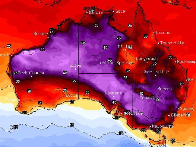
The coming days will see temperatures almost top out at 40C in multiple capital cities but one will see its toastiest day for almost a year.
Victoria has essentially sat out the worst of summer – indeed it hasn’t seen a really hot day for months.
While Australia has sizzled, the southern states have been uncommonly mild.
But not for much longer.
A short, sharp blast of heat over Melbourne could see Sunday’s temperature top out at as much as 38C.
It comes as much of the east, including Sydney could see temperatures jolt into the mid-thirties as the week progresses. And Perth could be within grasping distance of 40C.
But further north in Queensland, the deluge and flooding caused by Cyclone Kirrily will still be felt over the coming days with major flood warnings and heavy rain remaining in Townsville.
An area of high pressure is pushing from the west towards south east Australia over the coming days and that’s dragging down hot air from the interior.
High pressure often brings clear skies and settled conditions and during summer this can lead to scorching weather.

Wednesday in Melbourne will be a mild 21C rising to 25C on Thursday and then dip down to 22C on Friday. But then the mercury really cranks up to the low thirties on Saturday and the high thirties on Sunday.
Yet despite Melbourne’s Sunday 38C high this is not regarded as a heatwave as it won’t last. Right behind the area of high pressure is a cold front which will within hours bring those highs down.
It will struggle to reach a top of just 22C on Monday.
If the mercury does get to 38C on Sunday it’ll be a full 12 degrees above average for February which usually sees mean maximum temperatures of around 26C in Melbourne.
Melbourne hasn’t recorded a day over 35C so far this summer, let alone 38C. Indeed the last time the temperatures in the city passed 35C was last March. There was a 40.5C high on February 17 last year.
You have to go back to 1984 to find a year where there were no 35C plus days during January in the CBD.
Inland it could get even warmer with 39C in Bendigo on Sunday, 40C in Wodonga and Shepparton and 43C in Mildura.

Heatwaves in NSW, ACT
Adelaide, in common with the rest of the south and east, will also see summer warmth this weekend. A 26C maximum on Wednesday will climb to 33C on Saturday and 35C on Sunday before heading down to 23C at the start of next week.
Much of New South Wales and the ACT will be engulfed in a heatwave from Thursday into next week with those high temperatures lingering, unlike in Victoria.
A severe heatwave is set to hit Canberra and Sydney on the weekend.
The capital is looking at a six day run of temperatures in the thirties. After a 26C high on Wednesday, it is forecast to reach 31C on Thursday, 36C on Sunday and 33C on a showery Monday.
Sydney will also bake – but for fewer days. Expect mid to high twenties to round out the week, with some showers on Wednesday. The weekend will begin with 28C on a cloudy Saturday reaching 34C on a sunny Sunday and 36C on Monday before dropping back into the twenties for Tuesday.
Elsewhere in NSW it will be scorching. Newcastle is looking at a 38C Sunday, Dubbo is in for days in the high thirties and then 41C on Sunday as will Wagga Wagga. On the same day Singleton could reach 42C and Tamworth is in for 40C on both weekend days.
The best places of relief will be the north coast where the weekend will be in the low thirties with the same for the south coast.

Fears of major floods in Queensland
Brisbane will be warm but won’t reach the highs of NSW or Victoria. Temperatures will bob around the 30C-32C for the next week.
The torrential rain in Queensland is set to ease but the flood threat remains. There is a major flood warning for the Condamine River in south east Queensland which has seen up to 150mm along its route.
Moderate flooding at Dalby and major flooding near Ranges Bridge is possible.
There is also a major flood warning for the Moonie River at Flinton, west of Toowoomba.
Rain remains in Townsville where up to 35mm could fall on Thursday and Friday and then 15mm on Saturday and Sunday.
Almost 40C in Perth
Some showers in Darwin with highs of around 33C during the weekend.
That high pressure is already present in Western Australia so it will see the highest temperatures for the remainder of this week but less so on the weekend as the system is in the country’s east.
Perth will sweat with 39C on Wednesday and Thursday falling slightly on Friday and then a more pronounced drop to 30C on Saturday and 27C on Sunday.
Tasmania will stay relatively mild with mid-twenties maximums for Wednesday and Thursday and even sliding into the high teens on Friday. The warmest day will be Saturday with a high of 26C.
Originally published as Australia weather: Melbourne set to see hottest day for almost a year as multiple capitals sizzle


