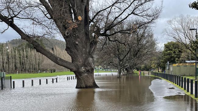
Another busy night for Tas SES with the north taking most of the brunt of damaging winds
Tasmania Police confirm a group of 13 people requested rescue after a walk up the mountain went wrong on Monday afternoon. But they weren’t the only ones caught in the extreme conditions.
Tasmania
Don't miss out on the headlines from Tasmania. Followed categories will be added to My News.
Wild weather continues to strike across Tasmania on Monday, September 2. Here’s The Mercury’s rolling coverage with the latest.
September 3: Police are once again appealing for bushwalkers to be prepared for extreme conditions and the unpredictable after a major rescue mission on Monday night.
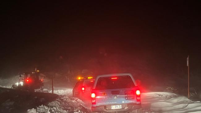
Emergency services were alerted to a group of 13 people calling for help at kunanyi/Mt Wellington about 4.15pm.
Officers say the walkers had been walking in the mountain before the weather closed in.
The group underwent a day bushwalk with mobile phones but minimal food and water and no equipment to spend the night in case of emergency, police said.
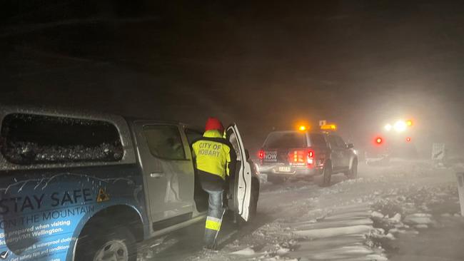
Authorities arranged for City of Hobart personnel to assist the walkers to safety.
Police confirmed a further five walkers were located during the rescue mission and walked back down the mountain at the 1100m level.
“They too were similarly unprepared for such a journey,” police said.
Inspector Darren Latham said that it was incredibly frustrating that police were forced to repeat the same warnings – especially during a severe weather event.
“The Bureau of Meteorology, the SES and Tasmania Police have been issuing warnings to the community regarding the severe weather event since last week. This included several bushwalker weather alerts,” he said.
“Bushwalkers should always prepare for the worst. Our emergency service personnel often put their own lives at risk during rescues, so it is frustrating when the situation could have been avoided.”
The essential safety tips are to be prepared with appropriate equipment, research your trip, inform others, carry communication devices and be mindful of mobile phones.
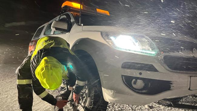
7pm: A joint rescue operation is attempting to reach a group of stranded walkers, the Hobart City Council chief says.
CEO Michael Stretton confirmed council workers were working alongside Tasmania Police in the mission with the group believed to be in a hard to reach section of the mountain.
“We are unaware of the specific circumstances of the group of walkers at the moment and will provide more details when possible,” Mr Stretton said.
“The focus of our crews is to see these people safely rescued.”
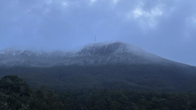
Conditions on kunanyi/Mt Wellington were extreme on Monday evening with subzero temperatures and gusts of up to 109km/h.
The temperature at 6.30pm was -3C with a wind chill factor making it feel like -22.6C.
He urged the community to take extra care in these dangerous conditions and to carefully consider a visit to the mountain before heading up.
“We can’t guarantee that we’ll always be able to rescue stranded walkers so visiting the mountain in these extreme weather conditions comes with high risks,” he said.
Pinnacle Rd to the summit of kunanyi/Mt Wellington has been closed most of the week because of high winds, rain and snowfalls.
2.30pm: Tasmania leading insurer has experienced a surge in claims due to the extreme weather event.
RACT chief Mark Mugnaioni said the RACT had taken 600 calls on Monday morning from Tasmanian who have experienced property damage.
The insurer is urging all policyholders who are affected to call 13 27 22 or go online to lodge a claim.
“The sooner members lodge their claims, the sooner we can go about assessing and trying to fix the damage caused by the storms,” Mr Mugnaioni said.
Qualified tradespeople were already on the group performing urgent works where immediate measures were needed to secure property, he said.
“As soon as it is safe to do so, we will have more staff on the ground and more resources in the affected areas to help assess the damage to properties.”
He said the number to lodge claims was more than 370, and was expected to rise.
“It is still unclear exactly how many homes and properties have been damaged, and we urge anyone affected to call us as soon as possible,” he said.
“RACT would like to thank emergency services, community organisations and utilities for their efforts to keep communities safe and connected during this time.”
Derwent River threatens more communities
12.45pm: The impact zone of flooding from the Derwent River is expected to hit more areas with an alert issued for low lying areas for New Norfolk and surrounds.
Sorell Creek is also expected to be impacted.
The flood watch and act urges people to monitor conditions and prepare to leave with flooding likely in the next 12 hours.
Hospitals’ emergency care still open
Midday: The Tasmanian Government is continuing to closely monitor the current severe weather situation and its impact on health services across the State.
Minister for Health, Mental Health and Wellbeing, Guy Barnett, said Tasmanians in the North and North-West requiring emergency care should continue to present to hospital Emergency Departments in the region.

“I can confirm that following some temporary disruption overnight that required a move to generator power, mains power has now been restored at the North West Regional Hospital,” Minister Barnett said.
“A Code Yellow response was called at the hospital this morning in response to the disruption and has now been stood down.
“The hospital is prioritising the continued delivery of essential services, with some non-essential services postponed as required, including outpatient appointments and elective surgery. The hospital will contact any patients impacted, and we thank them for their understanding.
“Mains power has also been restored at Deloraine District Hospital, with work ongoing to restore mains power at Beaconsfield District Hospital, which has been operating on generator power after being impacted by power outages.
“My thanks goes out to each and every healthcare worker who are working during this time of emergency to ensure their fellow Tasmanians are getting the care that they need.”
Road closures
As of 1,35pm:
- Allison Road North Motton
- Ansons Bay road – Ansons River causeway – closed due to flooding
- Bashan Road, Victoria Valley – for around 5km from Victoria Valley Road
- Bishopsbourne Road, Bishopsbourne – Road Closed
- Boland Street Launceston – from Tamar Street to Lawrence Street – due to flooding until further notice.
- Bracknell Lane, Bracknell – Between Liffey Road and Bracknell – Road Closed
- Bridgenorth Rd from Long Plains Rd to Southbridge North Road
- Bridle Track Road, Kimberley – from Beulah Road to Kimberley Road.
- Craigburn Road, Hillwood – from Batman Highway to Post Office Road
- Deviot Road between Motor Road and the Batman Highway – Trees & Power Lines Down – Alternate Route via the West Tamar Highway to the Batman Highway.
- Dove Lake Road, Cradle Mountain
- Dunorlan Road, Dunorlan – Power Lines and Trees Down
- Edinborough Rd Abbotsham, closed adjacent to No 100, can be accessed from either end – no through traffic.
- Elphinstone Road Cressy – approx 3 kms west of Cressy township – until further notice due to powerlines down.
- Esplanade from the end of Macquarie Street, George Town – Tree removal
- Fishers Tier Road, Deddington – flooding over bridge.
- Glenfern Road, Glenfern – from Mount Lloyd to Glenora Road – Closed due to Flooding
- Glengala Road, Cranbrook
- Glenora Road – From Sharland Ave, New Norfolk to Uxbridge Road, Bushy Park – Closed due to flooding
- Gordon River Road – Maydena to Strathgordon due to a tree on the road near the Russell Fall turn-off. Other trees likely to fall.
- Gordon River Road – Closed at Bushy Park between Derwent River bridge and Glenora road – flooding
- Grange Road, Swansea
- Heemskirk Road – Reece Dam to Granville Harbour
- Highland Lakes Road – closed at the two junctions with Haulage Road – detour onto Haulage Road.
- Hillwood Jetty Road, Hillwood – Tree on road
- Hart Street Launceston – between Hoblers Bridge Road and Birch Ave
- Industry Road, Pipers River – between Bridport Road and Troopers Track Road
- Isandula Rd – Gawler River to Wilsonia Road
- Kimberley Road at the Railton end is closed until further notice – due to a fallen tree.
- Kindred Road Sprent – 3kms from intersection with Castra Road
- Lake Dobson Road, Mt Field – Road Closed
- Lambert Street Ravenswood closed between Prossers Forest Road and Faraday Street – until further notice due to flooding.
- Lyell Highway, both directions from Queenstown to Derwent Bridge – trees over road – road blocked. Remains closed until further notice. Work will continue into Monday 2 Sep 24. – REOPENING ETA 3 September
- Lyell Highway, Nive River Bridge Wayatinah – flooding over bridge.
- Lyell Highway, Lawitta – Water on the road
- Low Head Road at the Low Head Tourist Park, due to the removal of a storm damaged tree, restricted access for local traffic may be provided as removal works allow.
- Macquarie Heads Road, between the Caretakers Cottage and the beach access – Road Closed due to road collapse and erosion.
- Mersey Main Road closed – from Railton Road intersection to Tarleton Road intersection – due to flooding.
- Montana Road, Montana – Road Closed
- Mooreville Road Shorewell Park – between West Mooreville Road and Malonga Drive is closed until further notice – due to fallen trees and power lines.
- Murchison Highway, Hellyer Gorge – Road locked by Trees – REOPENING ETA 4PM (2/9)
- Nant Lane, Bothwell – Between Highland Lakes Road and Denistoun Road – Water across the road
- Native Plains Road, between the intersection of Merseylea Road and Railton – Water over the road
- Old Coach Road, Cranbrook
- Old Vermont Road closed between Vermont Road to Henry Street – until further notice due to flooding.
- Opossum Road Launceston – closed from Hobart Road to Norwood Ave – until further notice due to fallen trees – until further notice – clearing operation will be commenced on Monday 2 Sep 24.
- Pitts Lane, Bishopsbourne – between the Liffey River and Liffey Road – Road Closed
- Pelverata Road, Pelverata between Vincents Road and Umfrevilles Road.
- Pieman Road, Tullah – from the Murchison Highway through to Reece Dam and Henty Road Granville Harbour through to Reece Dam. – closed due to trees and power lines across the road.
- Punchbowl Road Punchbowl – closed from Punchbowl Reserve to Amy Road Punchbowl until further notice due to fallen trees.
- Pinnacle Road, kunanyi/Mount Wellington is closed at Bracken Lane.
- Quamby Brook Road, Quamby Brook – Road Closed
- Mersey Main Road, Railton – Between Railton Road and Henslows Road – High fas flowing water
- Roseburn Road, Rosevale – Road Closed
- Roses Tier Road, Blessington near the Fire Station – Removing Power Lines & Trees – Alternate Route via New Tier Road
- Sheffield Road – Between Nook Road and Melrose Road – Fallen tree across powerlines – REOPENING ETA 12PM (2/9)
- Sky Farm Road Claremont – closed due to poor conditions – the council have advised that the established alternate route has also deteriorated and is suitable for light 4WD vehicles only
- South Road Penguin – closed in the vicinity of 100
- South Riana Rd – Winduss Rd to Gunns Plains Road
- South Street, Carrick – Road Closed
- Sunnyside Road, Railton between Gambles Road and Hardwicks Road – closed due to power lines across the road
- Victoria Valley Road, Ouse – Road Closed near Watsons Marsh
- Waddamana Road, between Shannon River at the Hermitage end to Waddamana Village – Water on the road
- Waratah Road, Luina – blocked due to several fallen trees. – REOPENING ETA 3PM (2/9)
- Wayatinah Road near the Nive River and Liapootah Power station – rapidly rising water levels are encroaching the roadway making it very hazardous for motorists. It is anticipated that it will be impassable in the next 30 mins or less.
- West Kentish Road is closed until further notice – due to power lines down. SES are on site.
- Westwood Road, Westwood – Road Closed
- Winkleigh Road Exeter – between Crawfords Road and the West Tamar Highway – due to trees down and power lines.
- Zeehan Highway, Zeehan – Road Closed due to Trees – OPEN TEMPORARILY – Will be closing again later this afternoon (2/9)
Hazardous roads:
- Anthony Beach Road, Smithton between Smithton and Stanley – tree blocking road
- Bass Highway – 10km west of Elizabeth Town – large potholes in road
- Belvior Road Cradle Mountain – 4×4 only
- Bishopsbourne Road Bishopsbourne and Carrick – water and debris on the roadway in those areas – caution recommended.
- Cradle Mountain tourist road – 4×4 only
- Causeway 1 – Seven Mile Beach to Midway Pt – sea water and rock debris on the road.
- Highland Lakes Road between Poatina junction to Miena – snow reported, 4WD only
- Irishtown Road, Smithton 1km from Bass Highway intersection – tree blocking the road
- Lyell Highway, 5 kms west of New Norfolk – water over the road.
- Macquarie Road Cressy – North of Baringfield Road – large body of water on the road covering both sides of the road.
- Oaks Road between Bracknell and Carrick – use caution due to trees, power lines, and water on the road- until further notice.
- Highland Lakes Road: 20mm Snow patches from Pine Lake to Breona. 4×4 or 2wd with chains. Road closed at Haulage Hill, detour in place.
- Tasman Highway, Springfield (Sideling) – trees across the road.
- Waterhouse Road, Waterhouse – power lines down and across the road
- Yanns Road, Rocky Cape – power lines down and across the road
More mobile sites cut off
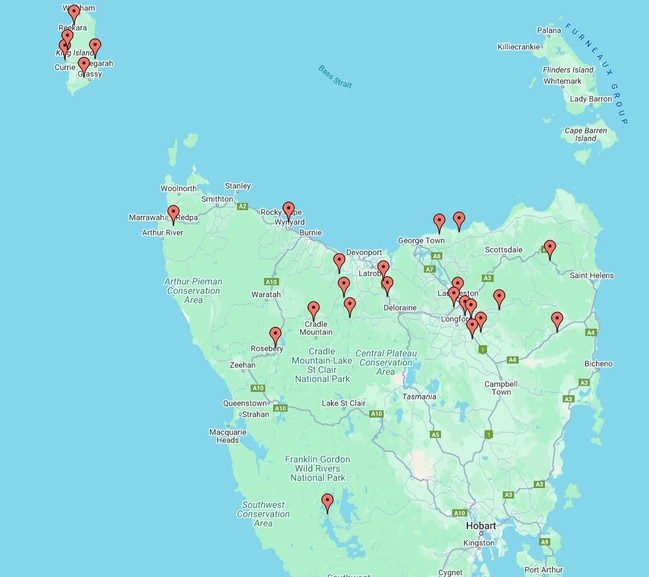
8.45am: Telstra boss says 26 mobile sites were off air due to a loss of mains power.
“We had got it down to nine late yesterday but that number has unfortunately climbed again overnight as more sites lost power due to the weather,” Telstra regional engagement manager Marc Brown said.
“Almost all of the impacted sites are in northern Tasmania.”
On Sunday morning 38 sites had been cut off.
“Severe storms in Victoria overnight also has impacted one of our transmission towers that connect King Island, impacting the majority of the mobile towers on the island,” he said.
“Restoring mobile connectivity to all impacted areas as quickly as we can remains our highest priority.”
2000 properties remain without landline services.
“Our technicians and contractors will be back on the road again with temporary generators, restoring services when it is safe to do so and we can access the impacted sites,” Mr Brown said.
School closures
8am: Severe weather has closed down Glenora District, Wilmot Primary and Forest Primary for Monday, September 2.
Some other northern schools such as Exeter Primary will remain open for students despite having no power.
Danger not over yet despite easing conditions: SES
Tasmania SES executive director Mick Lowe said damaging winds and rainfall persisted overnight with the north of the state continuing to take the brunt.
In the 12 hours to 5.10, SES were called-out a total of 347 times with 57 in the South, 207 in the North and 83 in the North-West.
Peak wind gusts reached 157km at King Island Airport and 130km at Launceston Airport.
There remains concern for low lying communities in the Upper Derwent Valley with those in Meadowbank to Macquarie Plains and Styx River, Bushy Park to Macquarie Plains and surrounds urged to evacuate now under an emergency warning.
“Properties in the region of the Derwent River, Meadowbank to Macquarie Plains and Styx River, Bushy Park to Macquarie Plains and surrounds face a significant risk of flooding and it is likely roads and properties will become inundated by floodwaters and become inaccessible,” Mr Lowe said.
“People in this are asked to use all the information available to ensure which warning is relevant to them and when planning what action they will take.”
“Two evacuation centres remain open – one at the Derwent Valley Sport and Recreation Centre on Derwent Terrace in New Norfolk, and another at the Memorial Hall in Circle Street.
“If you haven’t already left the area – consider going to stay with family or friends. Make the decision as early as possible as parts of the Lyell Highway and Glenora and Boyer Roads may become flooded.
“This weather situation is prolonged and evolving, and we are continuously monitoring it. It’s crucial for people to make informed decisions and prioritise their safety.”
Despite easing weather conditions over the next 24 hours, he warned the risk of damage and flooding hadn’t passed.
“With damaging winds and rainfall, we’re seeing trees down across the state and I urge people to be alert, especially when driving on the roads,” Mr Lowe said.
“It is imperative that the community remains informed and up-to-date with TasAlert to make good decisions and stay safe.”

