
Tasmania weather: Flood warnings, snow and rain forecast this weekend
A cold front and slow moving trough is bringing heavy rain, with multiple flood warnings current across the state. There’s more to come — including some snow. FULL FORECAST >>

Hobart & South
Don't miss out on the headlines from Hobart & South. Followed categories will be added to My News.
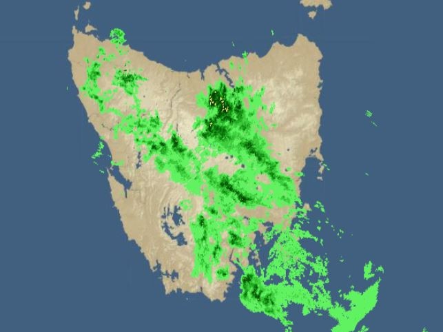
A cold front and slow moving trough is bringing heavy rain, with multiple flood warnings current across the state.
The Bureau of Meteorology says a low pressure system will form to the east of Tasmania Saturday afternoon and will remain there throughout Sunday and until Monday morning.
The low is expected to move away to the east late on Monday allowing a ridge of high pressure to cross the state on Tuesday.
LATEST NEWS:
- Search for missing man continues in worsening weather
- Where you can still buy a family home for under $500k
- Man who killed pensioner with ‘extraordinary cruelty’ freed
A warning to sheep graziers is current for the Midlands, East Coast, Upper Derwent Valley and South East forecast districts — and the City of Hobart has advised Pinnacle Road will be closed at 9pm at the Springs due to predicted snow.
“Sheep graziers are warned that rain and showers, cold temperatures and southerly winds are expected during Saturday and Sunday,” the bureau states.
“Areas likely to be affected include the South East forecast district and parts of the Midlands, East Coast and Upper Derwent Valley forecast districts. There is a risk of losses of lambs and sheep exposed to these conditions.”

An initial flood watch is in place for the North, North East, North West, Huon, Derwent and South East with minor flooding likely from Saturday afternoon.
Isolated moderate flooding is possible at some locations in the northeast with the trough slowly moving into western Tasmania today as a cold front approaches the west.
The front and trough will then cross Tasmania Saturday morning. During Sunday a low is expected to deepen to the east of the state.
The Bureau says catchments are wet and will be responsive to the forecast rainfall, with four-day rainfall totals from Friday to Monday of 30-60mm forecast for the central north, northeast and southeast with higher totals of 100mm possible in the east and south coastal areas.
âš ï¸MINOR #Flood Warning issued for #SouthEsk River. Widespread 15–25 mm rain forecast, higher totals possible. Minor flooding likely at #Fingal and #LewisHill Saturday afternoon. See https://t.co/V9LYfDAYDq for details and updates; follow advice from @SESTasmania. #TasFloodspic.twitter.com/bXnRLm1ap4
— Bureau of Meteorology, Tasmania (@BOM_Tas) October 22, 2021
River rises are expected with the forecast rain and areas of minor flooding are likely to develop from Saturday afternoon. Moderate flooding is possible at some locations in the northeast catchments.
Catchments likely to be affected include:
- North Esk River
- South Esk River
- Meander River
- Macquarie River
- East Coastal Rivers (north of Bicheno)
- Ringarooma River
- North Coastal Rivers
- Tamar (Launceston)
- Mersey River
- Huon River
- Channel Coastal Rivers (South East Cape to Gordon)
- Derwent River
- Jordan River
- Coal River
- East Coastal Rivers (south of Bicheno)
- South East

Check out our picks of the best bites of the dark delights
If you haven’t been yet, there’s still time to catch Winter Feast – Tassie’s tastiest food ritual returns this Thursday. Here are a few delectable treats I highly recommend, writes Alix Davis

‘Immense grief’: Donations flow to support devastated Kang family
The community is rallying around the family of a young Brisbane woman who tragically died alongside her partner while holidaying in Tasmania.