
Bureau of Meteorology issues severe weather warning for damaging surf on North-West, West and South coasts
Passengers on the Spirits of Tasmania can expect a bumpy ride this weekend, with swells of up to 11m predicted for much of the state’s coast.
Lifestyle
Don't miss out on the headlines from Lifestyle. Followed categories will be added to My News.
- Coldest day of the year as snow, single-digit minimums forecast
- Record broken in short-lived heatwave
AN icy blast is set to turn Tassie into a winter wonderland this weekend.
With a vigorous cold front set to cross Tasmania on Saturday morning, the Bureau of Meteorology says snow is set to fall as low as 600m in the south and west.
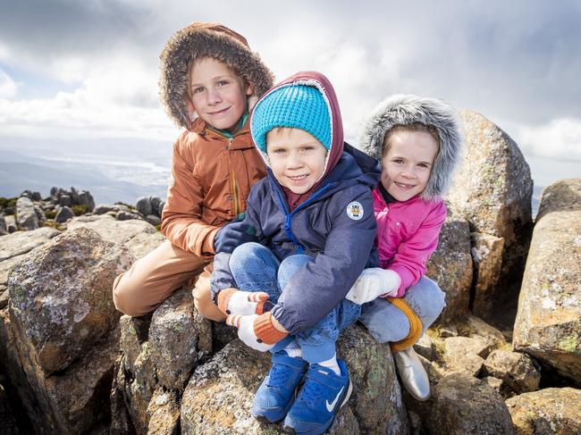
Jim Fjeldsoe and his family travelled to Tassie from Brisbane, and are looking forward to some snowy weather.
“We’ve been on Bruny Island and the kids were swimming on the weekend,” he said.
“Now we’ve been rugged up on Mt Wellington.”
He said it was the first time they had visited Tasmania with their kids – Patrick, 9, Evie, 6, and Finn, 4 – and they were having a ball.
“We’re rugged up with plenty of layers,” he said.
The family initially planned to travel here in September, but their plans were put on hold due to Queensland’s COVID-19 outbreak.
“We were really happy when the government opened to us again,” he said.
“It was a bit touch and go last week, but we’re stoked to be here.”
For anyone in the south hoping to have a snow day, duty meteorologist Anna Forrest said people could head to anywhere over the 700m mark.
“But because the ground is still quite warm, it may not settle. It will definitely be falling, but it may not stick around for long,” she said.
To top off the snowy weather, the Bureau of Meteorology has issued a severe weather warning for damaging surf for people in King Island and parts of the Western, South East and North West Coast Forecast Districts.
Swells of up to 11m are predicted for the West and South coasts on Sunday morning.
There is some exceptionally large swell and seas on the way for #Tasmania#Tas this weekend. Pictured is the total wave height for 10am Sunday on Meteye. Keep up with latest warnings, forecasts and Meteye at: https://t.co/zopf5oZwhy? and https://t.co/ZkXK9KAbzfpic.twitter.com/8LkQTjUiEH
— Bureau of Meteorology, Tasmania (@BOM_Tas) April 9, 2021
The state has jumped from the warmest April day on record to snow in less than a week, but Ms Forrest said it wasn’t that unusual for this time of year.
“This is the winter side of autumn, and last week was the warmer side,” she said.
“Things will warm up again next week, but nothing as warm as last week.”
Hobart will reach a rainy 15C on Saturday and 13C on Sunday.
Tassie heritage home stars in top TV renovation series
They came to Tassie from Sydney and fell in love with our island state – now Susan Angel and Rod McFarland are showcasing their impressive but difficult home renovation on a popular TV series
New lifeline for kids of veterans and first responders
Thousands of children from military and first responder families will now have access to critical help — dubbed the “Yellow Pages for mental health” — as they deal with the impact of service-related trauma.