
RUNNING FOR COVER: Campground scatters as storm cell hits
The Bureau of Meteorology has just upgraded the threat level posed by a very dangerous storm cell currently battering the hinterland.

Sunshine Coast
Don't miss out on the headlines from Sunshine Coast. Followed categories will be added to My News.
UPDATE 5.15PM:
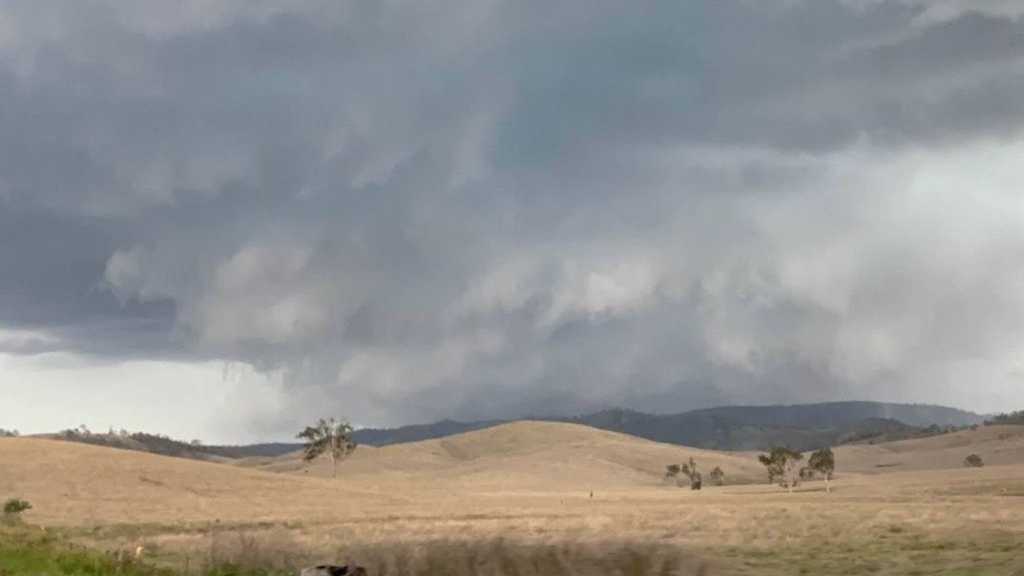
BLUFF Creek Campground manager Vicki Johnson said they were waiting anxiously to see what else Mother Nature had in store this afternoon, as hail had started to pepper their Kenilworth camping area.
She said hail about the size of a five-cent piece was hitting them at the moment.
"The wind's pretty hectic," Ms Johnson said.
She tipped the wind to be at least 50km/h at the moment.
"Everyone was running for cover and putting cars away," she said.
"Who knows what's next."
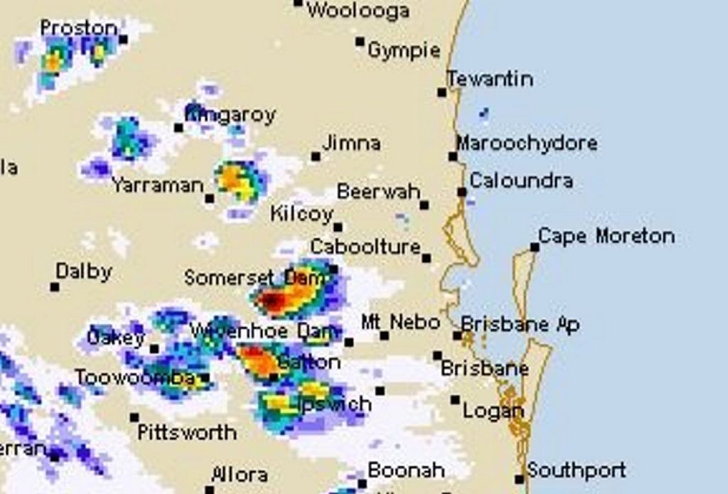
The Bureau of Meteorology has identified another "very dangerous storm" cell west of Maroochydore which is making its way north.
That cell was expected to impact areas of Noosa and Gympie in the next 10-20 minutes.
A broader thunderstorm warning was issued just before 5pm, advising Maroochydore, Gympie, Kingaroy and Caboolture would all be potentially affected by the intense weather systems.
UPDATE 4.35PM:
A POWERFUL storm cell impacting the Sunshine Coast hinterland has been upgraded to a 'Very Dangerous Storm' with "giant hail" of 5cm diameter or more and destructive wins of 125km/h or more possible.
Kilcoy, Maleny and Conondale were the Coast towns hit so far and the storm was expected to hit Yandina just before 5pm and Caboolture just after 5pm.
Rainfall of up to 75mm in about an hour was also possible, forecasters advised earlier today.
UPDATE 4PM:
A SEVERE Thunderstorm Warning has been issued for the Sunshine Coast this afternoon.
The Bureau of Meteorology issued the warning for damaging winds and large hailstones about 10 minutes ago.
The storm cells are currently hitting Esk and are moving northeast and forecasters have predicted the powerful systems will hit the Sunshine Coast hinterland towns of Maleny and Montville by 4.50pm.
UPDATE 3.20PM:
STORM cells are making their way towards the Sunshine Coast, edging across Ipswich, Gatton, Wivenhoe and Somerset Dams as they bear down on the region.
A particularly powerful cell is currently impacting Somerset Dam and is headed towards Caboolture, before it makes it way further across the Sunshine Coast.
EARLIER:
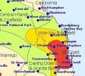
THE Bureau of Meteorology has warned giant hail and winds above 125km/h are possible as powerful storm cells build momentum this afternoon.
Hail above 5cm in diameter, classified as "giant", and "destructive" winds were possible in isolated storm cells, as part of a broader system which is developing on the Darling Downs at the moment and is set to make its way across the Sunshine Coast.
Bureau meteorologist Andrew Bufalino said there had been "quite an explosive development" in thunderstorm activity out to the eastern Darling Downs this afternoon which had sparked the warnings.
"There's a fair bit of thunderstorm activity developing on the eastern side of the Darling Downs," he said.
Those storm cells were moving northeast towards the Sunshine Coast as they made their way eventually out to sea.
Mr Bufalino expected the storms to starts impacting the Sunshine Coast from late this afternoon and into the evening.
The Coast was advised to brace for damaging winds (90km/h up to 125km/h) and large hail (2cm or greater in diameter).
Heavy rainfall was also tipped, with widespread falls of up to 40mm expected but some areas could receive up to 75mm within an hour or so.
That scale of rainfall may trigger flash flooding in some parts.
The Bureau earlier tweeted that "isolated, very dangerous storms" with "giant hail" and "destructive winds" were possible across southeast Queensland.
Severe #QldStorms with large hail, damaging winds & heavy rain are likely across #SEQLD today. Isolated very dangerous storms with giant hail (≥ 5cm) and destructive winds (>125km/h) are possible. Stay up to date with warnings via: https://t.co/cc91xbTW7L #GoldCoast #Brisbane pic.twitter.com/xNQ0kjvIeA
— Bureau of Meteorology, Queensland (@BOM_Qld) November 17, 2018
Originally published as RUNNING FOR COVER: Campground scatters as storm cell hits
Sunshine Coast sale and auction results, week ending June 14
Sunshine Coast recorded 34 property sales over a million dollars last week, the latest auction and sales results reveal.

Boy suffers serious injuries in shocking balcony fall
A young child has been rushed to hospital with potentially life-threatening injuries after he fell off a balcony at a Sunshine Coast home.

‘Still alive’: Haunting last message as mystery shrouds son’s Bali death
The grieving parents of a 23-year-old Noosa FIFO worker have spoken about their agonising fortnight as they wait for his body to be returned from Bali and questions remain over the lead-up to his death.

Cash boost call: Qld container rebates ‘should be doubled’
Queensland’s Container Refund Scheme returns should be doubled to 20c in a bid to keep up with inflation and encourage more residents to take part, a parliamentary committee has heard.

‘Honour, integrity and decency’: Tributes flow for political, dairy industry force
Community and agricultural leaders have paid tribute to Gympie region farmer and devoted family man and industry advocate Shane Paulger after his death at the age of just 67.

Maroons fan runs the gauntlet while on meth, no licence
A diehard Queensland rugby league fan has been found driving on drugs after returning a zero blood alcohol reading after police saw him drive into a tourist park.