Fire turns to ice as storms batter eastern states
Insurers are inundated with 15,000 claims after hailstones wreak havoc in eastern states.
Australia’s fatal summer of fire has become one of icy demolition, as severe weather battered Canberra and swept through Sydney leaving a trail of destruction.
Bureau of Meteorology forecaster Gabrielle Woodhouse said fire-affected areas in NSW could experience quick run-off, flash flooding and roadways covered by ash and debris after Monday’s storms.
The @BOM_NSW are tracking a number of large and dangerous storm cells across NSW. These storms are likely to produce damaging, locally destructive winds, large and possibly giant hailstones and heavy rainfall.
— NSW RFS (@NSWRFS) January 20, 2020
For assistance in storms, contact the @NSWSES on 132 500. #nswrfs pic.twitter.com/pGpTqaT02C
“Due to the fire and drought conditions, quite a lot of the vegetation is weakened and this means that trees and trees’ branches are going to be much more likely to come down due to wind gust or a bit of heavy hail,” Ms Woodhouse said.
Properties in western Sydney, Macarthur, the Southern Highlands and the Illawarra were hit hard by severe thunderstorms and many homes lost power after 7.30pm as emergency crews worked into the evening to repair damage from the storm.
About 3000 homes were without power on Tuesday morning after hail, strong winds and lightning interrupted power to 14,000 properties in the Sutherland Shire and northern beaches on Monday night.
Crews are working to safely restore power to about 14,000 homes & businesses after severe storms brought strong winds, lightning & hail across the Sutherland Shire & northern beaches.
— Ausgrid (@Ausgrid) January 20, 2020
This video shows the storm as it hit Kirrawee. Stay at least 8metres away from fallen wires. https://t.co/2i2os2EOfd
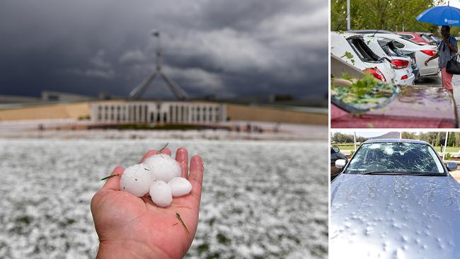
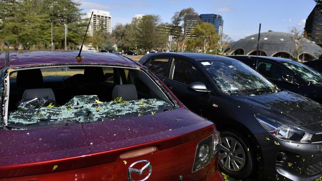
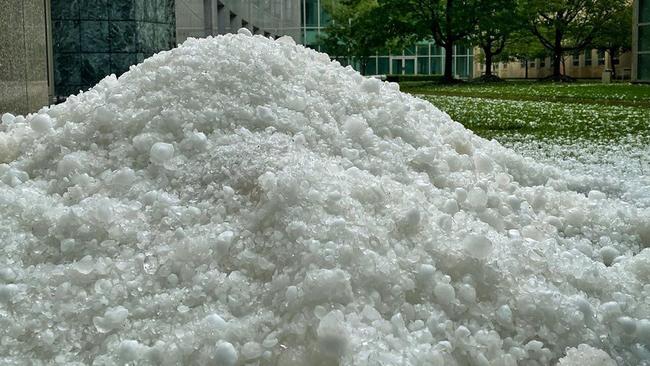
In Canberra, hailstones the size of golf balls bombarded the city, turning day to night as it pummelled Parliament House and other national institutions, before carving a trail of destruction up the coast to NSW.
Hundreds of windscreens were smashed at Old Parliament House, the Australian National University and other parts of the city.
The Insurance Council of Australia recorded 15,000 claims by people from Canberra, Queenbeyan and parts of southern Sydney. The total also includes claims made by people from Melbourne who were lashed with hail on Sunday afternoon.
Insurance Council Australia head of communications Campbell Fuller said that insurers were generally coping well. “It will be a challenge at certain times. You will find that when you have hundreds of people calling one call centre there may be some slight delays but in most cases those insurers will be able to get to those customers quickly,” Mr Fuller told 2GB.
“Insurers do anticipate disaster season and it’s an unfortunate part of Australian life that roughly from October through to March or April insurers anticipate a large number of claims,” he said. Mr Fuller said that if people have comprehensive car insurance and a high level of building insurance they would be covered against hail damage.
Monday afternoon’s 15-minute storm prompted more than 1750 calls for help to the ACT Emergency Services Agency.
Emergency services worked through the night to respond to roof and window damage, fallen trees and electrical hazards.
The worst-affected areas were Belconnen in Canberra’s north, the city centre and the inner south.
ACT Ambulance Service attended to two people with minor injuries from the storm. Branches were stripped from trees during the destructive blast, with a wind gust of 117km/h recorded at Canberra Airport.
More than 1000 homes lost power, but most had been restored during the afternoon.
Canberra tour guide Tim the Yowie Man tweeted a picture of the National Sound and Film Archive’s roof being punctured “like bullets”.
Hail at the National Film and Sound Archive HQ in Acton, Canberra 'punctured the roof like bullets'. @canberratimes pic.twitter.com/qIq1zqeIzq
— Tim the Yowie Man (@TimYowie) January 20, 2020
It remained open to visitors on Monday despite the damage.
“No staff or visitors have been injured, and the NFSA collection is safe from damage,” a spokesman told AAP. The thunderstorms also hit Newcastle and Wollongong on Monday.
Bureau of Meteorology senior forecaster Phillip Landvogt said conditions will settle in Melbourne and Sydney today, but a cold front developing over the Great Australian Bight could see storms develop in South Australia and Melbourne on Thursday.
“There is the chance of a storm late on Thursday in Sydney and Canberra with that approaching cold front, however we aren’t expecting them to be as intense or produce the large hail that was observed in Canberra yesterday,” Mr Landvogt said.
Warm and gusty north-westerly winds will cause severe to extreme fire danger ratings in parts of South Australia and Victoria on Wednesday before the cold front moves through the area.
Showers and possible thunderstorms in Melbourne are expected late on Wednesday and into Thursday.
The maximum temperature in Melbourne will drop from 32C on Wednesday to 21C on Thursday. Sydney will reach a top of 37C on Thursday.
A possible storm and shower is expected when the cold front reaches Sydney on Friday dropping the maximum temperature to 28C.
A monsoon is developing in the tropics where the heaviest rainfall is expected over the next few days. Widespread rain and thunderstorms across northern Queensland, northern half of the Northern Territory and the Kimberley in WA.
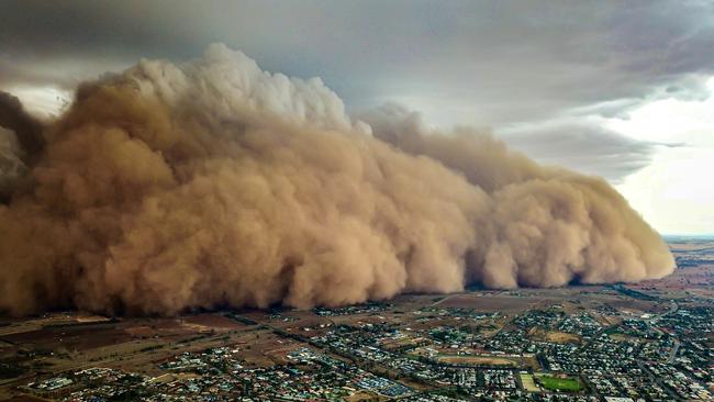
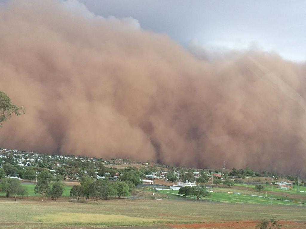
In Victoria, fire-ravaged townships were issued with urgent flood warnings, NSW’s drought-starved centre and northwest were plagued by billowing dust storms, and on Queensland’s Gold Coast residents were told to brace for further flash floods.
In the NSW Blue Mountains, a 16-year-old boy and a 24-year-old man were struck by lightning near the Three Sisters lookout in Katoomba and rushed to hospital with burns.
Behind all the chaos, the ever-present threat of returning bushfires loomed large as the deadly season of devastation continues.
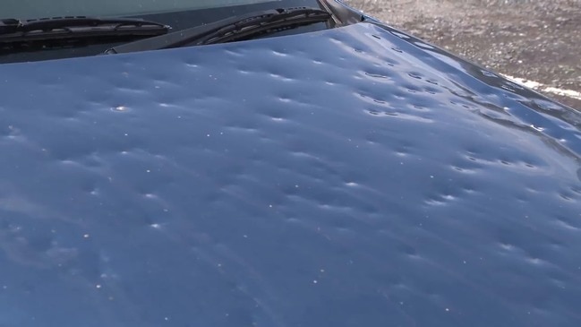
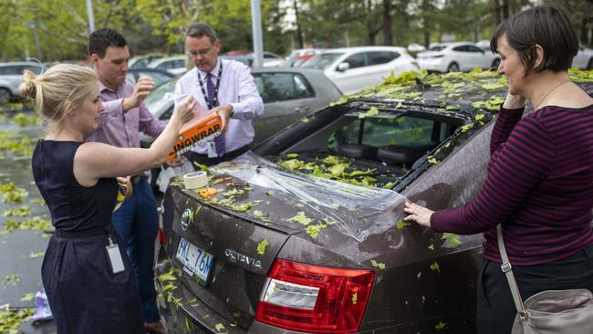
Canberra was hardest hit by Monday’s freak hailstorm, with locals stuck on insurance hotlines while others helped each other with their vehicles.
By 6pm, the ACT Emergency Services Agency had received more than 1750 calls for assistance from the severe storm activity and emergency services personnel worked through the night to respond to roof and window damage, fallen trees and electrical hazards.
Eleanor Goodwin, a 40-year-old librarian, rushed out of Canberra’s Treasury building to find her family car smashed and confused drivers trying to patch up what was left of their vehicles.
Hail destroying the trees at Parliament House.. poor gardeners pic.twitter.com/bHEES1yhHy
— Tamsin Rose (@tamsinroses) January 20, 2020
“People were using Glad Wrap and sticky tape to cobble mirrors and things back together,” Ms Goodwin said. “Someone very kindly lent me some. It’s a six-year-old car — the back window is completely smashed, both mirrors are off, the front window is badly cracked, and every panel has a huge dent.
“I phoned the insurance people but there is now an automated message saying people hit by the storm should lodge online. I’ve put in a claim, but it may end up a total write-off. I have lived in Canberra all my life and I have never seen anything like it.”
Parliament House was at the centre of the storm and the lawns were snowy white with ice despite it being the middle of January.
ACT Chief Minister Andrew Barr was among those personally affected by the hailstorm. “My car copped a golf ball-sized hailstone and thousands of others fared even worse,” Mr Barr tweeted.
“It will take a while to clear all this up and there may be more storms tonight.”
Insurance groups on Tuesday were unable to say how many claims they had received or how much money they might have to pay out, but the bill could hit the millions. Almost 3000 insurance claims were filed for a hailstorm in Melbourne last week but the Insurance Council said many more were expected from Canberra’s storm on Monday.
Abrar Shabren, from the Bureau of Meteorology, said the areas that saw the most hail were east of Wagga Wagga, around the ACT and in southwestern Sydney.
“We saw hailstones about 4.5cm in diameter — about the size of a golf ball — fall in the southwest areas of Sydney like Campbelltown,” he said. “We have also had multiple reports of hailstones the size of tennis balls but we have been unable to confirm them.”
Mr Shabren said the BOM had issued two severe thunderstorm warnings encompassing NSW’s east coast from Wollongong, south of Sydney, to Lismore, in the state’s northeast.
The storms that brought the barrage of hail also delivered yet another day of welcome rain to fire-affected areas on the south coast with Bendethera near Moruya recording 41.2mm between 9am and 5pm on Monday.
“Areas around Bega and Shoalhaven also got a decent amount of rain, about 20mm and Nowra got even more than that with Bumbulla seeing 32mm,” Mr Shabren said. “However the northern areas of the state saw more isolated rainfall, reaching about 20mm in areas north of Lismore and near Glen Innes.”
left: Parliament House, Canberra, January 5
— Josh Butler (@JoshButler) January 20, 2020
right: :Parliament House, Canberra, January 20
(pics: AAP) pic.twitter.com/i7LWfrkHOv
Both NSW SES and the BOM anticipate that conditions will ease tomorrow as storm systems move out to sea, although a return to wet and windy weather is forecast for the end of the week.
NSW Rural Fire Service inspector Ben Shepherd warned that the rain had not brought the bushfire crisis to an end.
More Coverage
Add your comment to this story

Defiant Bandt denies Gaza hurt Greens vote
Adam Bandt has denied his hardline Gaza stance cost him votes and, despite lower-house losses, vowed to use the Greens’ Senate power to shape the ‘most progressive parliament’.

‘Hiding powdered mushrooms in everything’: Erin’s message
Erin Patterson was 'excited' to show her online friends a photo of a food dehydrator she purchased, and told them her husband was 'controlling' and put the church above their family.
To join the conversation, please log in. Don't have an account? Register
Join the conversation, you are commenting as Logout