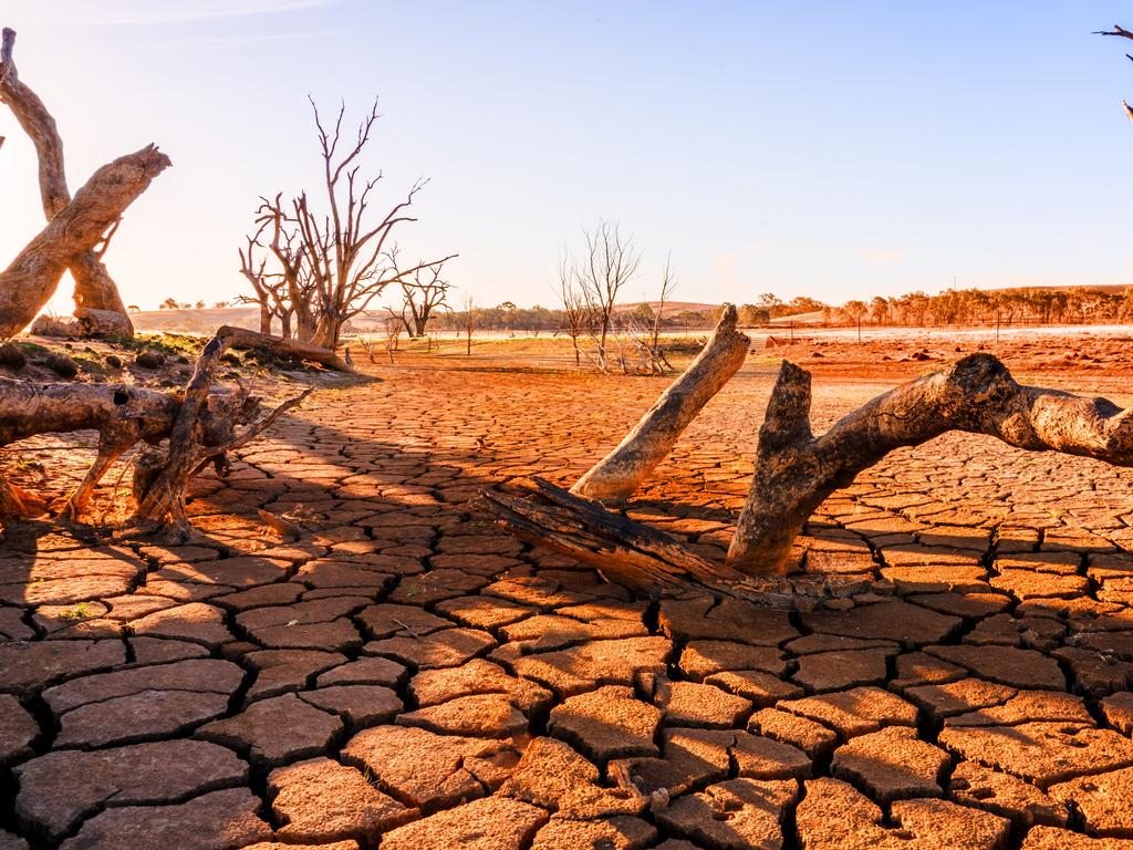
Wet and wild ride as drought shows signs of breaking, dust storms roll in
Storms whip up dust in NSW while Victoria is battered by hail with more forecast today.
Large parts of eastern Australia could be transformed from drought-stricken to flooded, due to a new round of wild weather forecast for Monday that have already whipped up massive dust storms in regional NSW.
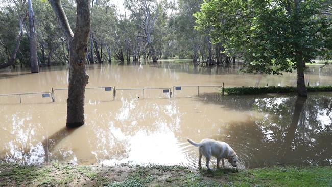
Rainfall in recent days has caused some rivers in NSW to flow for the first time in months or years, while in Queensland solid rain has significantly lifted water volumes in one major dam.
Overnight in Victoria southern and eastern suburbs of Melbourne were battered by golf ball sized hail and wild weather.
The State Emergency Service received about 1,500 calls in the last 24 hours for help as the “supercell” hammered parts of Melbourne.
Hail stones in Melbourne whilst other areas of Victoria are still burning #melbourneweather #hail #AustraliaBurns https://t.co/APUelibWUo
— Lizabella Bella 🾠(@LizabellaBella) January 19, 2020
The SES responded to calls of flooding, trees down and drains blocked from the hail.
Serious hail storm in Melbourne. Worlds weirdest city for weather. pic.twitter.com/n4O8UK3ApB
— judy murray (@JudyMurray) January 19, 2020
One cricket field in Warrandyte looked as if it was covered in snow and there were reports a supermarket had to be evacuated after the roof collapsed due to hail.
Severe weather warnings remain for the east and central parts of the state with the possibility that almost half a month worth of rain could fall in those parts of the state.
Landslides could form in the bushfire affected east.
Although smoke haze has eased, more storms are forecast this afternoon on the first day of the Australian Open.
An eerie scene st Highfield Park straight after massive hail in Melbourne East #melbournehail pic.twitter.com/iN70EWU7ih
— Peter Macaulay (@pjmacaulay) January 19, 2020
The Bureau of Meteorology had issued severe thunderstorm warnings for Victoria’s Gippsland region and the northeastern suburbs of Melbourne, along with flood warnings.
“We’re expecting widespread shower and thunderstorm activity developing on Monday,” said BOM extreme weather forecaster Sarah Scully. “There is the potential to have up to 50-100mm with any of those severe thunderstorms.”
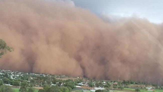
Damaging winds caused by thunderstorms across central NSW have already caused large dust storms plunging some towns into darkness during the day.
Videos posted to social media showed dust storms descending on Dubbo and nearby towns on Sunday night that were so thick they blocked out the sun.
Nyngan‘s Grace Behsman took this video of a huge dust storm rolling in as they approached town. Watch til end - scary moment when the storm overtakes and everything goes black. The dust storm has swept the west & is encroaching Dubbo. Remember: not everyone’s celebrating rain 😔 pic.twitter.com/5VMLrFbrrT
— Lucy Thackray (@LucyThack) January 19, 2020
A gust of 94 km/h was recorded at Parkes about 6.30pm on Sunday while a gust of 107 km/h was recorded at Dubbo about 7.45pm, the BOM said.
Bureau meteorologist Rose Barr said Sunday’s rain was concentrated across central and northern parts of the state and east of the ranges. Many towns on the Mid North Coast and the northern rivers region received between 100 and 180 millimetres from 9am to 10.30pm on Sunday.
Another day, another dust storm!
— Craig McDonald (@CraigMc52834124) January 19, 2020
Near Narromine yesterday. pic.twitter.com/Cu9nz0p1Oz
In the southern part of the state, high winds saw storms race overhead quickly, resulting in lower measured falls. Downpours over the past few days have provided relief for parts of drought- stricken NSW and helped firefighters slow the spread of bushfires and build containment lines ahead of increased fire danger mid-week.
Video showing the massive dust storm rolling into Dubbo tonight. Video Credit: 7NEWS viewer Roshan Rayamajhi. https://t.co/OF81oZFF1j #dubbo #duststorm #7NEWS. pic.twitter.com/4AiGR7XibF
— 7NEWS Sydney (@7NewsSydney) January 19, 2020
Ms Barr said the Bureau was predicting active thunderstorms for Monday, particularly across southeastern and central-eastern parts of the state, as well as parts of the southwest slopes,” Ms Barr said.
But again they are likely to move quickly with some “extremely strong wind gusts”.
There could also be large hailstones.
Winds will shift and come more from the north and west mid-week, bringing drier and warmer air on Wednesday and Thursday.
“That means on both of those days we may end up seeing fire dangers increasing again and causing more problems for our fire agencies,” Ms Barr said.
But moisture will thankfully return on Friday and the weekend.
While the rain may help subdue some bushfires, Ms Scully warned the increased rain on fire sites could cause trees to fall.
“With the fires going through, it has burnt out all that vegetation and the surface runoff is far greater to pick up things like ash, rocks and trees branches which can be a real hazard,” she said.
Across the weekend, a coastal trough swept humid conditions across eastern NSW and southeast Queensland.
“This has resulted in widespread showers and storms with some torrential downpours, particularly across the north coast of NSW and also the Gold Coast area,” Ms Scully said.
“These were one-in-100-year rainfall events. Some of these areas had 250-330mm of rainfall.”
Hinze Dam in the Gold Coast hinterland increased in volume by 3.5 per cent to 85.4 per cent, with rainfall across its catchment area averaging a massive 246mm.
The state government-owned SunWater said it was continuing to monitor runoff activity.
“Depending on the location, it can take a few days or more for catchment runoff to reach water storages,” a spokesman said.
“Considering the recent dry conditions, initial rainfall may be absorbed within the catchments. However, this initial rain also means further rain has a better chance of becoming catchment runoff, so any additional rain in the coming days and weeks would be very beneficial.”
A spokeswoman for NSW Water Minister Melinda Pavey said that on the mid-north coast and far north coast “we see the full extreme variability of Australian weather conditions, with communities recently battling drought conditions now coping with a deluge of rain”.
“The flood risk in some areas is unfortunately an additional hardship, but the return of flows to rivers such as the Macleay, Hastings and Bellinger is in stark contrast to the declining river heights that have put water security in jeopardy in these regions.”
Water NSW said last week’s rainfall was a respite for drought-affected areas, but fell short of boosting dam storages.
“All regions, including the Sydney catchment, received low rain volumes that only generated short-lived flows in some river valleys, notably the Macquarie and Gwydir,” a spokesman said.
Ms Pavey’s department also said it had received reports of fish kills in the Macquarie Valley in the central west, where officers were considering opening up weirs on some tributaries.
Victorian Water Minister Lisa Neville said her state had not benefited hugely from rainfall. “We continue to experience below average rainfall and dry conditions in Victoria,” Ms Neville said.
“Recent storms have provided a little relief for some areas, but have not had any impact on the water storages or fire activity.”
With Ean Higgins


AUKUS port purchases alarm: fears of Chinese Communist Party links
Companies controlled by the family of a Shanghai businessman with connections to the Chinese Communist Party’s foreign influence arm have purchased two commercial properties located within port precincts earmarked for AUKUS submarine bases.

Labor urged to act on anti-Semitism
The Coalition has added pressure on the Albanese government to act on its anti-Semitism envoy’s report about combating rising anti-Jewish hate, demanding an explanation why it would wait for ‘unrelated’ reports before acting.