
Heavy rains, flash flooding predicted for Top End, more warm, dry weather for Central Australia
Temperatures are forecast to dip slightly for the Top End, and stormy weather is on its way. Find out more in this weather update.
Northern Territory
Don't miss out on the headlines from Northern Territory. Followed categories will be added to My News.
Heavy rain and possible flash flooding is on the way for the Top End as increased storm activity is set to sweep across the Northern Territory starting on Friday, the Bureau of Meteorology predicts.
Temperatures were set to drop a couple of degrees in the NT after residents experienced heatwaves over recent weeks, meteorologist Angus Hines said.
“Elsewhere across the central and southern desert areas, no such rain is coming,” he said.
“It’s another hot, dry day there [on Friday] with temperatures of around 40C.”
Darwin temperatures are set to peak on Friday at 35C and will sit in the mid to low 30s throughout the following week with high chances of rain and storms.
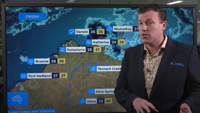
In the Red Centre the mercury will peak at 43C on Monday, but it is not forecast to drop below 40C for most of the following week.
A medium to high chance of showers and thunderstorms will hit the Top End on Saturday, with a slight to medium chance in the Gregory and Carpentaria Districts, and in the northern and eastern Barkly District.
Elsewhere it will be mostly sunny and hot with light to moderate northwest to northeast winds.
Forecasts look the same for Sunday with areas of cloud developing in the Lasseter District during the afternoon.
Click here for more information on heat stress and how to manage symptoms.
Monitor heat health warnings on the NT Health Facebook page.


Measles alert: Locations sick tourist visited during Territory trip
NT Health has issued a measles alert, along with a string of locations visited by a sick tourist during a visit to the Northern Territory. FREE READ.

‘Five locations’: How decades-old reports could crack Falconio case
The confidential reports, commissioned by the British government and given to NT Police, identified ‘five locations’ where Falconio could be, the expert says.