
Cyclone could dump half a metre of rain on parts of Top End
A TROPICAL cyclone likely to form off the Northern Territory coast this week could dump up to half a metre (500mm) of rain on parts of the Top End
Northern Territory
Don't miss out on the headlines from Northern Territory. Followed categories will be added to My News.
- CHANCE of cyclone forming this week to increase to 20-50 per cent
- CYCLONE Blake tracking the north WA coast
- REVEALED: how cyclones form and are named
- CYCLONE history: the biggest systems to last the NT
THE tropical low, which is expected to intensify early Thursday morning into a cyclone, is forecast to dump up to 200mm of rain across the Top End.
Some isolated areas could see up to 500mm of rain over the next three days as a result of the weather system.
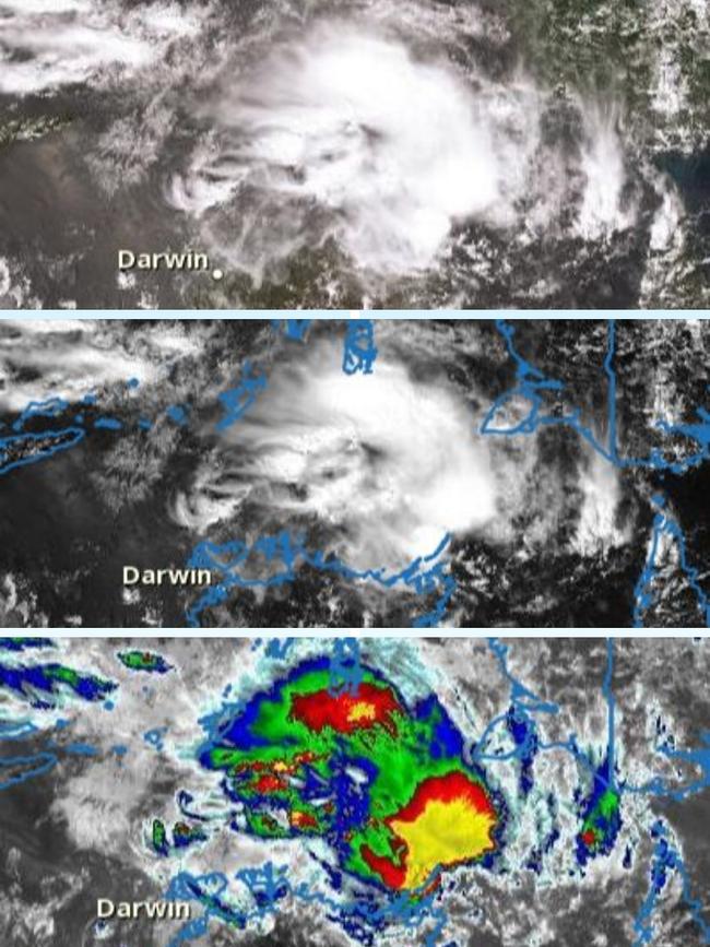
If the system intensifies as expected it will be called Cyclone Claudia.
It has the potential to reach a Category 2 system.
It is the first cyclone of the wet season for the region.
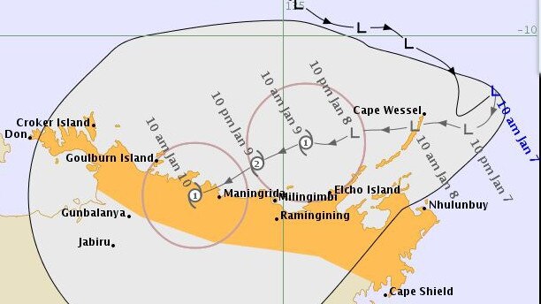
The Bureau of Meteorology’s Jude Scott said the system would likely cross between Maningrida and Goulburn Island.
“The weather impacts from this system will be dangerous,” Ms Scott said.
“We’re expecting to have gale-force winds in the region of 90km/h and that could be sustained over a great deal of hours, early Friday morning and throughout the day.”
The system is expected to weaken to a low once it makes landfall.
Ms Scott said the low would continue to bring heavy rain and lashing winds once it had made landfall.
A Tropical #Cyclone Watch has been issued for northeast #TopEnd from Cape Don to Cape Shield, including #Nhulunbuy. Rainfall and winds increasing along the coast from Wednesday. Find the latest at https://t.co/WfpZI3l8wShttps://t.co/cP24MRhfc6
— Bureau of Meteorology, Northern Territory (@BOM_NT) January 7, 2020
As of Tuesday evening, the cyclone was sitting about 200km north of Gove and moving west.
Ms Scott said because the low had developed over the Arafura Sea as opposed to water to the east or west of the NT, it was small and could change direction quickly.
An Incident Management Team was established on Tuesday.
The team will operate 24 hours a day.
Local controllers are holding meetings in communities expected to be affected by the system.
NT Police Assistant Commissioner Michael Hebb said the safety of residents within the direct firing line of the system was the focus.
Work is under way to inform those living in remote outstations of the weather conditions.
He urged people to be prepared and have a cyclone kit with supplies that could feed a family for up to 72 hours.
The system is predicted to bring abnormally high tides.
Mr Hebb urged people not to enter flooded waterways.
LIMITED TIME offer: NT News subscription – 50 per cent off* for the first 12 weeks
“It’s incredibly important that we remind member of the community not to try and cross over flooded roadways. If it’s flooded forget it. It’s just too much of a risk,” he said.
As of Tuesday night emergency services had not opened any cyclone shelters.

Crocs, economy on agenda as Territory government heads to Timor-Leste
The Northern Territory government will lead a delegation to Timor-Leste on Tuesday, aimed at strengthening economic relations, growing cultural ties – and sharing croc knowledge.

‘Intentional’: Off-duty correctional officer assaulted while walking dog
An off-duty corrections officer has spoken out at the emotional toll of the job after being slashed in a ‘targeted attack’ while out for a walk with his dog.