
Cyclone history: The biggest systems to lash the Northern Territory
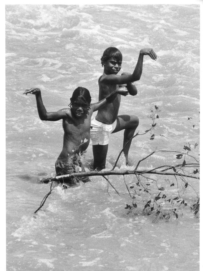
IT is 46 years since the Territory's most devastating cyclone – Cyclone Tracy – laid waste to the city of Darwin. We take a look back at a dozen of the Top End’s worst cyclones, from the NT’s first recorded cyclone – an unnamed monster in 1839 – to 2018’s Marcus, regarded as the worst since Tracy
Northern Territory
Don't miss out on the headlines from Northern Territory. Followed categories will be added to My News.
The NT’s first recorded cyclone – said to have an intensity comparable with Tracy – hit on November 25, 1839, wiping out the fledgling Port Essington settlement. We look at the Top End’s worst cyclones from the unnamed 1839 monster to 2018’s Marcus, rate the worst since Tracy.
HOW do cyclones form and get their name?
UNNAMED CYCLONE
CATEGORY: Unknown
WHEN: November 25, 1839
WIND SPEED: Unknown
RAINFALL: Unknown
IMPACT:
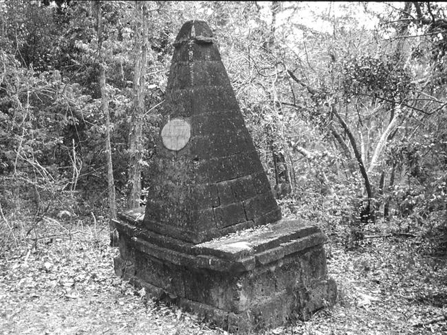
Not much is recorded about the NT’s first recorded cyclone except that it was severe. It hit the British military outpost of Port Essington on the Cobourg Peninsula on November 25, demolishing the settlement and leaving 12 recorded deaths.
There was a 3.2 metre storm surge and the HMS Pelorus was run aground.

It was said to have a intensity comparable with Tracy.
The cyclone hit only a year after the outpost was established.
But Essington was rebuilt, reportedly with the help of a brickmaker who was shipwrecked during the storm.
UNNAMED CYCLONE
CATEGORY: Unknown
WHEN:January 6-7, 1897
WIND SPEED 200km/h
RAINFALL: Unknown
IMPACT:
Possibly one of the most destructive cyclones ever in Australia, it was known as the ‘Great Hurricane’, and it killed 28 people.
The cyclone hit the tiny settlement of Darwin – then known as Palmerston – at 3.30am on January 7, and depending on the accounts, destroyed all or many buildings.
There was 296mm of rain recorded at Charles Point on the opposite side of the Cox Peninsula from Darwin overnight, and the pearling fleet of luggers in the harbour was said to be decimated, with 32 boats lost.
The winds hit more than 200km/h, and the barometric pressure reached about 950 hPa which was similar to Tracy.
It ripped off roofs and uprooted trees and telegraph poles and a news story a few days later described rain “descending in sheets like the bursting of a waterspout; the torrent lashed into fury by fierce gusts of wind that smite with the irresistible impact of a Titanic hammer”.
It was estimated to have cost £150,000 in 1897 values.
UNNAMED CYCLONE
CATEGORY: Unknown
WHEN: March 3-11, 1919
WIND SPEED: 200km/h
RAINFALL: 440mm in 40 near Wyndam in WA
IMPACT:
This cyclone formed near Wyndham in Western Australia with 440mm of rain falling in 40 hours.
It hit west of Charles Point – opposite Darwin – on the Cox Peninsula, on March 5.
While there was damage in Darwin, the real damage was done on Bathurst Island Mission which was destroyed by the winds and a five metre storm surge.
Thousands of trees were uprooted at Cape Don on the Cobourg Peninsula as the cyclone swung eastwards along the north coast and weakened, only to re-intensify several days later in the Gulf of Carpentaria.
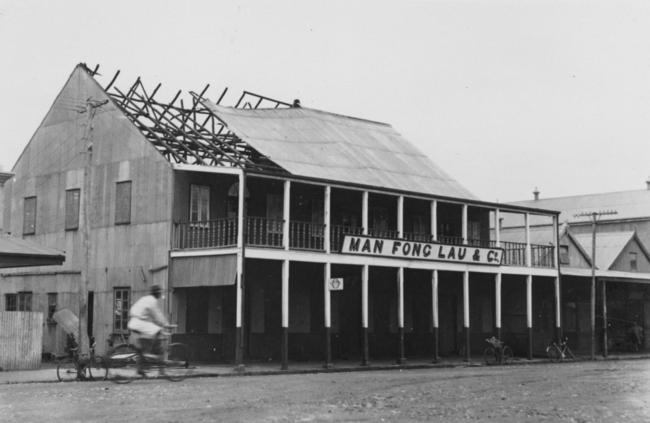
UNNAMED CYCLONE
CATEGORY: Equivalent of 3
WHEN: March 11, 1937
WIND SPEED: 160km/h
RAINFALL: 75mm
IMPACT:
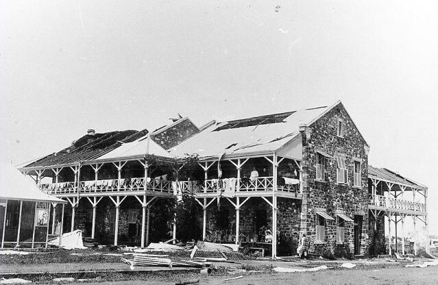
Leaving a trail of destruction in its wake, a cyclone of great intensity struck the town on Wednesday night and raged throughout the hours of darkness,” The Northern Standard newspaper wrote about the cyclone.
“When dawn broke on Thursday a scene that is hard to find words to describe was disclosed.
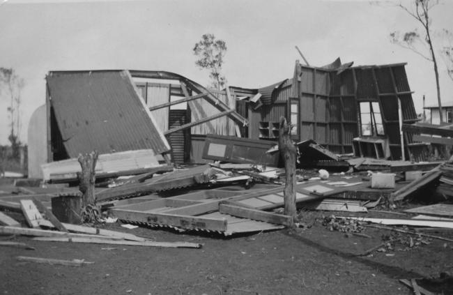
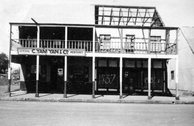
“Houses were blown down, buildings were unroofed and damaged, trees blown over and those left standing were denuded of foliage and were for the most part broken wreckage.
“No matter in what direction one looked the damage was all too apparent.’’
Like Tracy, the 1937 cyclone was preceded by several days of heavy rain and wind.
And like Tracy, the cyclone rounded Bathurst Island and headed in a south-westerly direction, straight for Darwin.
When the cyclone arrived on March 11, Darwin’s population was about 3000.
Also just like Tracy scientific observations were rudimentary and we’ll never know just how strong it really was but it seems it was not as intense as either the 1897 cyclone or Tracy.
The highest recorded speed gust was 160km/h, well below velocities measured during Tracy. Today we might call it a Category 3 cyclone.
However, some old timers who were here in 1937 say it was just as bad as Tracy.
Harry Macrides, for instance.
“Sure, there was only one person killed in 1937, and the damage was much less, but had Darwin been as big then as it was in 1974 I am sure that the loss of life and destruction would have been worse,’’ Mr Macrides said.
Once the winds died down, a review of the damage showed that while the older parts of the town and many older buildings had suffered badly, new buildings had not.
Trouble was, there were not many new buildings in Darwin in 1937.
The Commonwealth Government pledged only 2000 pounds to support Darwin relief and rebuilding even though there was an estimated 95,000 pounds damage.
But it also commissioned architect W. T. Haslam to draw up a damage report and he created the first set of building standards to take account of the likelihood of cyclones in Darwin.
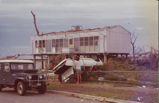
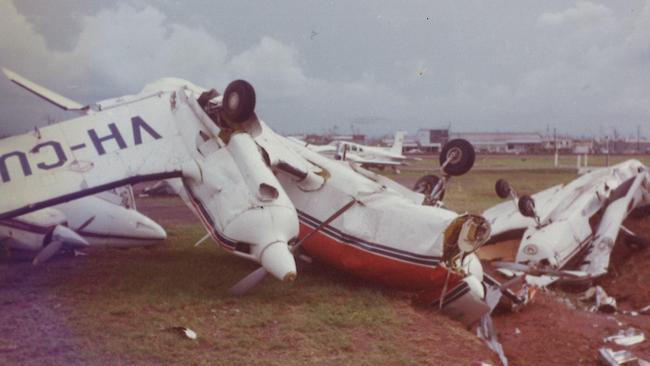
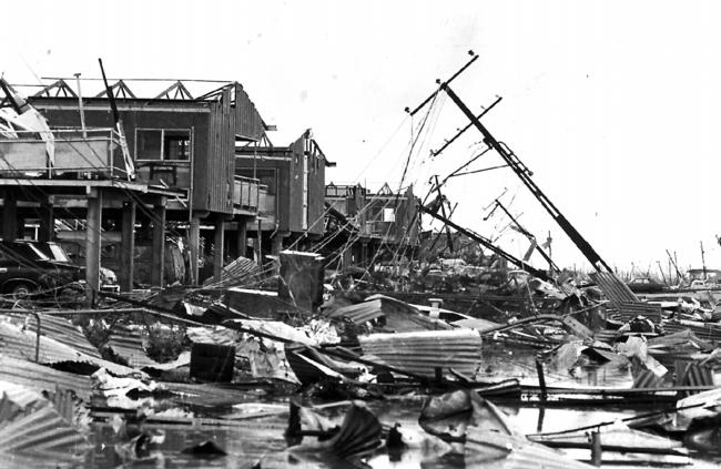
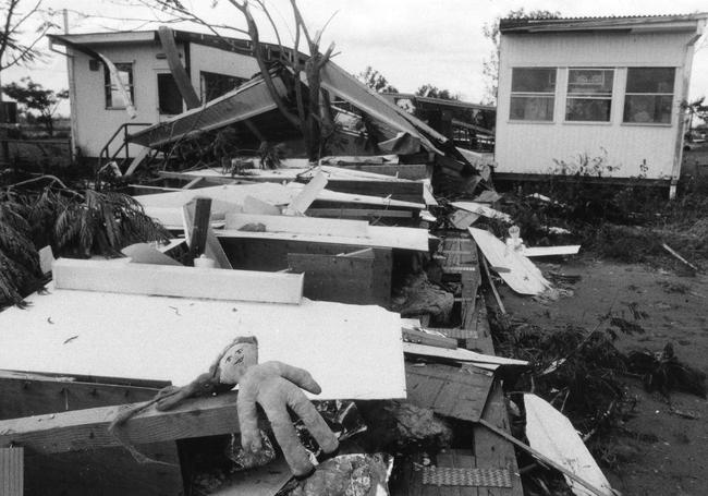
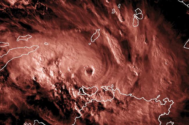
CYCLONE TRACY
CATEGORY: 4
WHEN: December, 1974
WIND SPEED: Up to 217km/h at Darwin airport
RAINFALL: 250mm in Darwin in 12 hours
IMPACT:
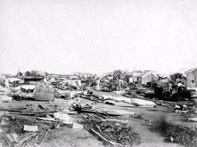
Think Darwin, think Cyclone Tracy.
Tracy was arguably the most significant tropical cyclone in Australia’s history, killing 66 people, and the destruction of most of Darwin and profoundly affecting the Australian perspective to the tropical cyclone threat.
RELATED
THE night Cyclone Tracy changed Darwin forever
THE man who saw Cyclone Tracy coming
DOCUMENT leak reveals Cyclone Tracy’s impact reached US
LISTEN to the sound of Cyclone Tracy here
By world standards, Tracy was a small but intense tropical cyclone at landfall, the radius of gale force winds being only about 50km.
While the official recorded wind speed was 217/km/h the measuring equipment broke during the storm so the real ferocity will never been known.
Tracy was first detected as a depression in the Arafura Sea on December 20, 1974.
She moved slowly southwest and intensified, passing close to Bathurst Island on the 23rd and 24th.
Then it turned sharply to the east southeast, and headed straight at Darwin, striking the city late on Christmas Eve and continued to devastate it into Christmas Day.
CYCLONE KATHY
CATEGORY: 5
WHEN: March 18 - 22, 1984
WIND SPEED: 232km/h at Centre Island
RAINFALL:325mm at Tennant Creek
IMPACT:
Severe Tropical Cyclone Kathy was a very intense cyclone in the Gulf of Carpentaria.
It formed initially from a tropical low southeast of Papua New Guinea and tracked to the west, reaching tropical cyclone intensity on March 18 prior to crossing Cape York near the mouth of the Pascoe River the following day.
Cyclone Kathy devastated the Sir Edward Pellew Group of islands, with a storm surge of 4.2m on Vanderlin Island, off the coast of Borroloola and several small camps were demolished.
A fishing fleet experienced hurricane winds and phenomenal seas for about eight hours as the tropical cyclone passed over them.

Three trawlers were forced aground above the high water mark and one sank with the loss of one crewperson.
Kathy crossed the mainland coast just north of Borroloola Township on March 22, where there was moderate to severe damage.
Large numbers of dugongs and green turtles were carried inland due to the flat open nature of the coast at landfall.
CYCLONE THELMA
CATEGORY : 5
WHEN: December 1998
WIND SPEED: 227km/h at the Tiwi Islands
RAINFALL: 425mm at Howard Springs
IMPACT:
Tropical Cyclone Thelma was the most intense tropical cyclone to traverse the Northern Australian Region in the last 35 years and was the first Category 5 system (on the Australian scale) observed in the Timor Sea.
The main impact on the Tiwi Islands was the disruption to communications and power supplies.
Vegetation in exposed areas suffered extensive damage, and a 3-4m rise in water level reported in Milikapiti (Snake Bay) caused minor coastal erosion.
In the Darwin area, minor damage occurred to houses and power supplies which were disabled by fallen trees.
CYCLONE VANCE
CATEGORY: 5
WHEN: March 17-22, 1999
WIND SPEED: Up to 267km/h at Learmouth
IMPACT:
Tropical Cyclone Vance was one of the strongest tropical cyclones to affect mainland Australia.
After developing off Darwin on March 17-18, 1999, Vance gradually intensified as it tracked west-south-west then to the south before crossing the coast near Exmouth on March 22 as a Category 5 system.

Vance caused severe structural damage to about 10 per cent of buildings in the town, though many more had other forms of damage due to the intrusion of rainwater.
CYCLONE INGRID
CATEGORY : 5
WHEN: March 2005
WIND SPEED: Up to 207km/h at McCluer Island west of Croker Island
RAINFALL: 438mm at Truscott
IMPACT:
Tropical Cyclone Ingrid caused significant impact on the Australian coast in March, 2005. It was unusual in that it is the only severe tropical cyclone in recorded history to hit the coastline of three different states or territories.
It crossed the Queensland east coast south of Lockhart River in Queensland at category four and moved across the Gulf into the NT.
The cyclone hit the small islands north of the Arnhem Land coast as a category five tropical cyclone but weakened slightly to category four as it crossed Croker Island and the Cobourg Peninsula,
It was at category three intensity as it traversed the Tiwi Islands north of Darwin and finally re-intensified to category four, before making a final landfall on the West Australian Kimberley coast at that intensity.
CYCLONE MONICA
CATEGORY: 5
WHEN: April 16 – 24, 2006
WIND SPEED: Up to 350km/h
RAINFALL: 340mm at Majestic Orchids, near Darwin River Dam
IMPACT:
Potentially Australia’s worst storm, Cyclone Monica spared Darwin after tearing into the Arnhem Land coast on April 24, in 2006.
Many communities, including Maningrida, Oenpelli and Jabiru, were destroyed or severely damaged.
The system weakened quickly once it hit land west of Maningrida.
The weather bureau said it was much like Cyclone Tracy, which devastated Darwin in December 1974.
Despite the impact of the cyclone, there had been no reports of serious injury or death in the Territory.
It was analysed as a tropical low in the far northern Coral Sea on April 16, 2006.
The low moved towards the southwest under the influence of a weakening ridge to the south.
There it reached tropical cyclone intensity on April 17 and began a more westward track toward Cape York Peninsula.
The system intensified to hurricane-force strength before making landfall 40km south of Lockhart River on the afternoon of April 19.
The system weakened over land, before entering the Gulf of Carpentaria as a weak tropical cyclone early the following day.
CYCLONE LAURENCE
CATEGORY: 5
WHEN: December, 2009
WIND SPEED: 211km/h at Mandorah
RAINFALL: 402mm at Napier Downs
IMPACT:
Despite not yet reaching tropical cyclone strength as the system passed very close to Darwin on December 12, it produced gales, heavy rainfall and some minor tree damage.
Laurence crossed the Kimberley coast in a remote location.
There was some structural damage reported from Kuri Bay with many trees down.
Windows were blown in at an office at Cockatoo Island and a storeroom was damaged at Koolan Island.
The low intensified over open waters west of Darwin into a tropical cyclone and was named Laurence on December 13, eventually crossing the Pilbara coast between Wallal and Mandora, east of Port Hedland.
Considerable damage was reported from properties in the area and an estimated 1500 cattle perished.
Heavy rain in eastern parts of the De Grey River catchment caused minor flooding and road closures.
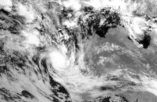
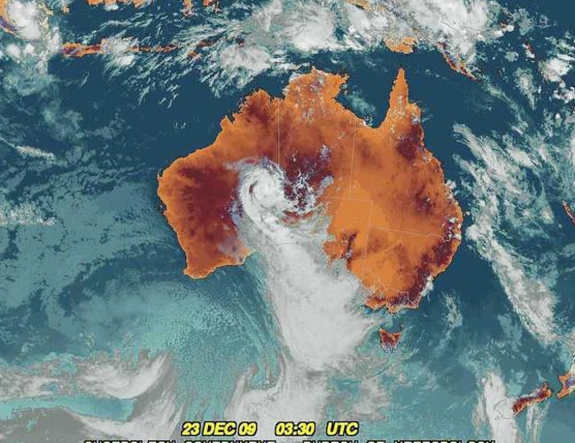
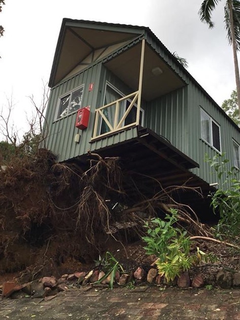
CYCLONE MARCUS
CATEGORY: 5
WHEN: March 16 - 24 2018
WIND SPEED: Up to 285km/h in WA
RAINFALL:
IMPACT:
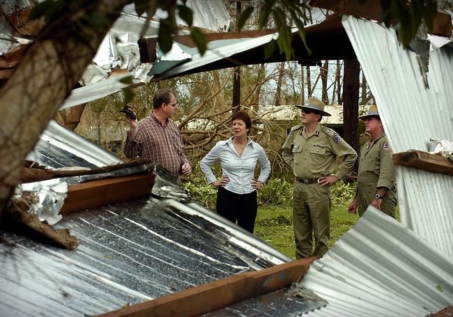
As Darwin residents slowly made their way out of the safety of their homes in the afternoon of Saturday March 17, 2018, the true extent of the worst cyclone since Tracy was fully appreciated.
There was an estimated $97 million in damage.
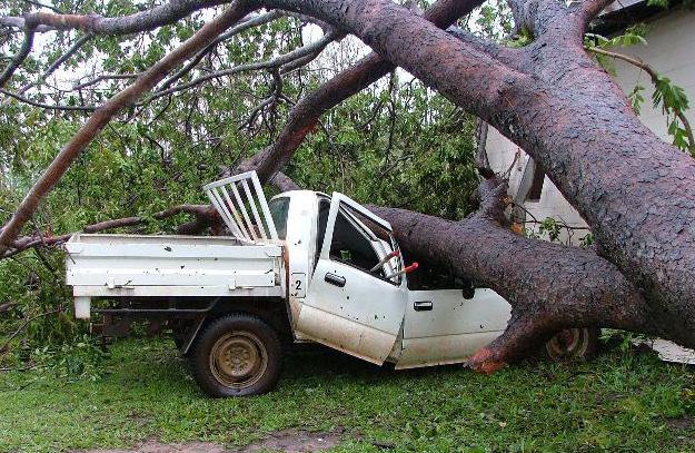
Cars were flattened beneath trees, roads were blocked and trampolines were missing, having been lifted and taken by the roaring winds of Cyclone Marcus.
It rates as the fifth most intense Australian cyclone by the Bureau of Meteorology with a minimum pressure of 905 hPa.
There were 27,000 homes that lost power and affected and the Insurance Council of Australia declared Darwin a ‘catastrophe’.

Marcus formed as a tropical low on March 15 in the Arafura Sea and moved southeast north of the Tiwi Islands before becoming a category one by March 16. It reached category two, hours before it crossed the NT coast the next day and passed through Darwin about midday before being downgraded to a category one about 4pm gale strength winds of 62km/h an hour were recorded for six hours with gusts up to 130km/h.
It later hit category five about 950km northwest off the coast of Port Headland.

NT team secures strong result at Emerging Socceroos Champs
The NT secured its best finish at the Emerging Socceroos Championships last week with several players stepping up in the premier national talent development program. Check out how they performed.

How to get tickets for AFLW Dreamtime clash in Darwin
Tickets are now live for the highly anticipated AFLW Dreamtime in Darwin encounter between the Essendon Bombers and Richmond Tigers. Find out how to get your tickets.