
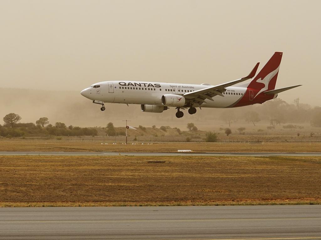
Canberra Airport reopens after fires forced shut down
Canberra Airport has been reopened hours after raging bushfires forced it to close today, but only limited flights will be operating.

Canberra Airport has reopened hours after dangerous bushfires forced it to close for much of the day.
The Kallaroo Road and Redwood Forest fires in the northern suburb of Piallago merged to create the Beard fire, spanning 424 hectares on Thursday afternoon.
The fire is burning within containment lines and has been downgraded from an emergency warning to watch and act level.
Canberra’s airport has reopened with Qantas operating a limited service, but Virgin and Singapore Airlines have cancelled flights for the rest of the day.
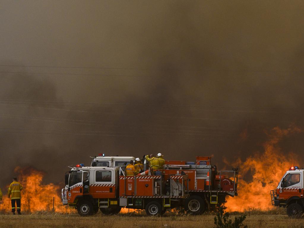
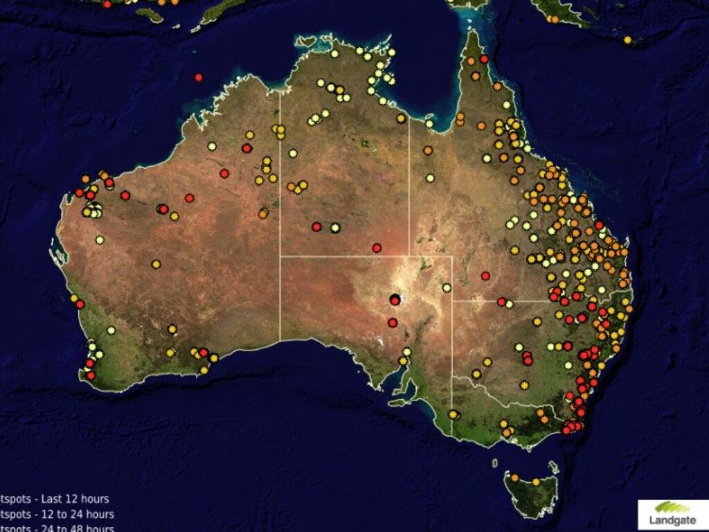
Multiple fires burning in Australia’s southeast have flared up today, with rising temperatures causing dangerous fire conditions across the country.
Canberra Airport was forced to close as the fire danger ramps up in the capital.
“Arrivals and departures are affected due to aviation firefighting operations,” the airport said in a tweet.
Customers were been told to check with their airline for up to date flight details.
A number of fires burning in NSW and the ACT have were upgraded to emergency warning level.
The emergency blaze south of Canberra Airport is approaching Beard, Oaks Estate and West Queanbeyan.
People in these areas have been told it’s “now too late to leave” and to seek shelter immediately.
“The fire may pose a threat to all lives directly in its path. People in these suburbs are in danger and need to seek immediate shelter as the fire approaches,” the ACT Emergency Services Agency said.
“Driving now is extremely dangerous and potentially deadly. People in streets north of Uriarra Road should LEAVE NOW towards David Campese Oval if safe to do so.”
EMERGENCY WARNING - BEARD, OAKS ESTATE AND WEST QUEANBEYAN pic.twitter.com/LES0ipFCuq
— ACT ESA (@ACT_ESA) January 23, 2020
Water bombers closing in on this fast moving grass fire near Canberra airport. Emergency warning in place for Beard, Oaks Estate and West Queanbeyan. Residents told to seek shelter, it’s now to late to leave. @SkyNewsAust pic.twitter.com/nkE5Wtgt0R
— Eliza Edwards (@ElizaEdNews) January 23, 2020
The fire is out of control, and firefighters are on the scene trying to contain the blaze.
A second fire near the airport that started on Thursday morning is at “watch and act”.
That bushfire is burning off Kallaroo Road in the suburb of Pialligo, close to a separate blaze that started on Wednesday.
Nearby residents were told to get their bushfire plans ready as authorities warned conditions could get worse.
According to reports a number of people have lost power and multiple traffic lights are out as a result.
The fires have also resulted in multiple road closures across the ACT, with a full list of affected areas listed below.
AS OF 1.44PM – BUSHFIRE ROAD CLOSURES
— ACTPol_Traffic (@ACTPol_Traffic) January 23, 2020
• SCHERGER - PIALLIGO AVE
• YASS RD - PIALLIGO AVE
• PIALLIGO - FAIRBAIRN AVE
• MAJURA - NORSE RD - COPPER CRES (EXIT NO ENTRY)
• COPPERS CROSS – NICKEL ST
• CANBERRA AVE - KENDALL AVE
• CANBERRA AVE - TOM PRICE
1/3
AS OF 1.45PM – BUSHFIRE ROAD CLOSURES
— ACTPol_Traffic (@ACTPol_Traffic) January 23, 2020
• CANBERRA AVE - NOMAD DR
• TOM PRICE ST - CANBERRA AVE
• RAILWAY ST
• FAIRBAIRN - OLD MAJURA RD
• BELTANA PIALLIGO
• NORSE RD - COPPER CRES AND CANBERRA AVE
• URIARRA RD - KENDALL AVE
• BELTANA RD - PIALLIGO AVE
• BEARD
2/3
AS OF 1.45PM – BUSHFIRE ROAD CLOSURES
— ACTPol_Traffic (@ACTPol_Traffic) January 23, 2020
• BRINDABELLA - PIALLIGO AVE
• BRINDABELLA - MOLONGOLO
• URIARRA RD - KENDALL AVE
• HINDMARSH DR - CANBERRA AVE
• TOM PRICE ST - CANBERRA AVE
3/3
An out-of-control blaze is also burning at Big Jack Mountain Rd, Rocky Hall in the Bega Valley area. It’s spreading quickly due to strong north-westerly winds.
Homes in the area of Mount Darragh, Rocky Hall and Stoves Road may come under threat as the fire spreads.
People in these areas have been warned to “leave now before it is too late” towards Pambula.
Another emergency blaze is burning near Adaminaby, a small town near the Snowy Mountains.
The Rural Fire Service have warned fire activity is increasing, and strong north-westerly winds are pushing the fire quickly towards Adaminaby.
Residents have been warned the fire may reach the area by this afternoon.
Areas including Shannons Flat, Ashvale, Anglers Reach, Old Adaminaby and Bobeyan Road may come under threat.
Anyone in these areas have been told to seek shelter as the fire front approaches.
A third fire has been upgraded to emergency level in the Southern Tablelands in the Clyde Mountain area.
The fire is more than 84,000 hectares in size and is burning on the southern side of the Kings Highway, in the Deua River Valley.
Fire activity is increasing in the Merricumbene area, and the blaze has grown from the Currowan fire on the southern flank.
People in the area have been warned to seek shelter as the fire front approaches.
Another fire has been upgraded to emergency level, which is burning over a large area between the Began and Moruya regions.
The Badja Forest Road fire is more than 240,000 hectares in size and is burning out of control.
This fire has joined with the Good Good blaze in and west and Werri Berri fire in the southwest.
People in Dignams Creek have been told to leave now towards Narooma if the path is clear and people in the Wallaga Lake have been told to monitor conditions.
Scorching temperatures and strong winds are affecting much of southeast Australia today.
Fire dangers are just starting to peak - and we're in for a long afternoon and night across many areas of NSW. It's already hit the high 30s in some areas. At midday there's 70+ fires burning, with two at Emergency Warning level. Stay up to date this afternoon. #nswrfs #nswfires pic.twitter.com/ssYwLY5MDl
— NSW RFS (@NSWRFS) January 23, 2020
Temperatures are expected to reach the low 40s in some areas of NSW, including in Sydney’s southwest, the Hunter Region, Illawarra region and some parts of the mid-north coast.
Firefighters had a short reprieve after rain fell across multiple firegrounds, but RFS Commissioner Shane Fitzsimmons said firefighters were on “heightened levels of alert” once more.
“There’s every potential for flare-ups and new ignitions to come out of some of these fire grounds, remembering we’ve got thousands of kilometres of fire perimeter,” he said.
“A lot of it has been extinguished, a lot of it is under control – but there are still pockets that are burning and smouldering and we don’t know how many additional roots, tree stumps or branches are likely to flare up under those conditions.”
A total fire ban is in place for seven regions across NSW, including the Far South Coast, Southern Ranges, Illawarra, Greater Sydney, Central Ranges, Greater Hunter and North Western.
Join the conversation

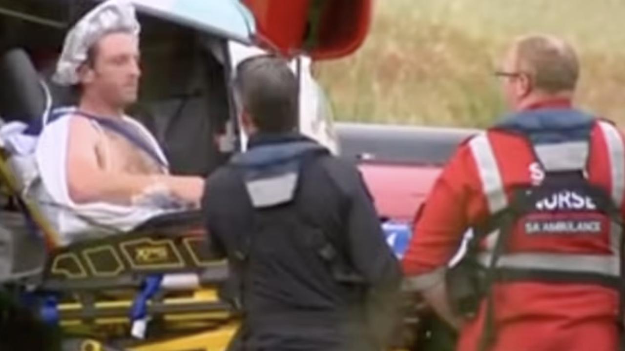
Qantas pilot named as crash victim
A Qantas pilot has been named as one of three victims who died in a horror mid-air crash in Sydney on Saturday.
Read more
Five injured in gas explosion at campground
Five people have been injured in a gas explosion at a campground in South Australia, with two of them in a serious condition.
Read more

Seaplane ditches into ocean at holiday hotspot
An investigation is underway after a seaplane carrying five people ditched into the ocean at a popular tourist hotspot.
Read more