
Sydney floods: 40 suburbs under evacuation orders, weather latest, road and public transport updates
The rain event smashing NSW is so large it has been described as “hard to fathom”. One statistic puts the scale in terms that are mind-blowing.


The rain event smashing NSW is so large it has been described as “hard to fathom”. But one statistic puts the scale in terms that are easier to understand, albeit mind-blowing.
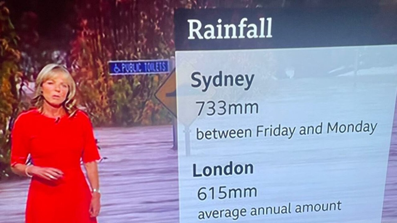
The BBC’s weather team put together a simple graphic that aired to audiences on Monday.
It showed that between Friday last week and Monday Sydney had been smashed by 733mm of rain.
In contrast, London — perceived as a rainy city — records just 615mm annually.
The graphic was shared by Nine News Europe Correspondent Brett McLeod who wrote: “BBC weather putting Sydney’s downpour into context. More rain there in 4 days than London gets in a year.”
BBC weather putting Sydney’s downpour into context.
— Brett Mcleod (@Brett_McLeod) July 4, 2022
More rain there in 4 days than London gets in a year. pic.twitter.com/FDkBCYGlK7
It comes as the East Coast Low which has caused all the weather drama in NSW is finally moving away, taking much of the rain with it.
But in exceedingly unwelcome news, forecasters have said another low is brewing and that could bring yet more heavy rain on the weekend to exactly the same areas that are already flooded.
A month’s worth of rain could drench NSW in the coming week. But that’s actually less than what fell over the last few days, showing just want a mammoth rain event Sydney and the surrounding areas have been through.
Stream more news on the environment with Flash. 25+ news channels in 1 place. New to Flash? Try 1 month free. Offer ends 31 October, 2022 >
The current system may be moving away but it’s leaving a trail of destruction in its wake and further flooding fears.
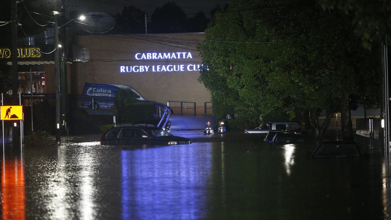
There are around 70 evacuation orders in place for about 40 suburbs in and near Sydney and nine evacuation centres have been set up for the at least 30,000 people who cannot remain in their homes. Meanwhile, scores of roads and railway lines have been flooded.
There’s a full list of the suburbs affected and the transport hold ups at the bottom of this article.
‘Hard to fathom’ a rain event so large
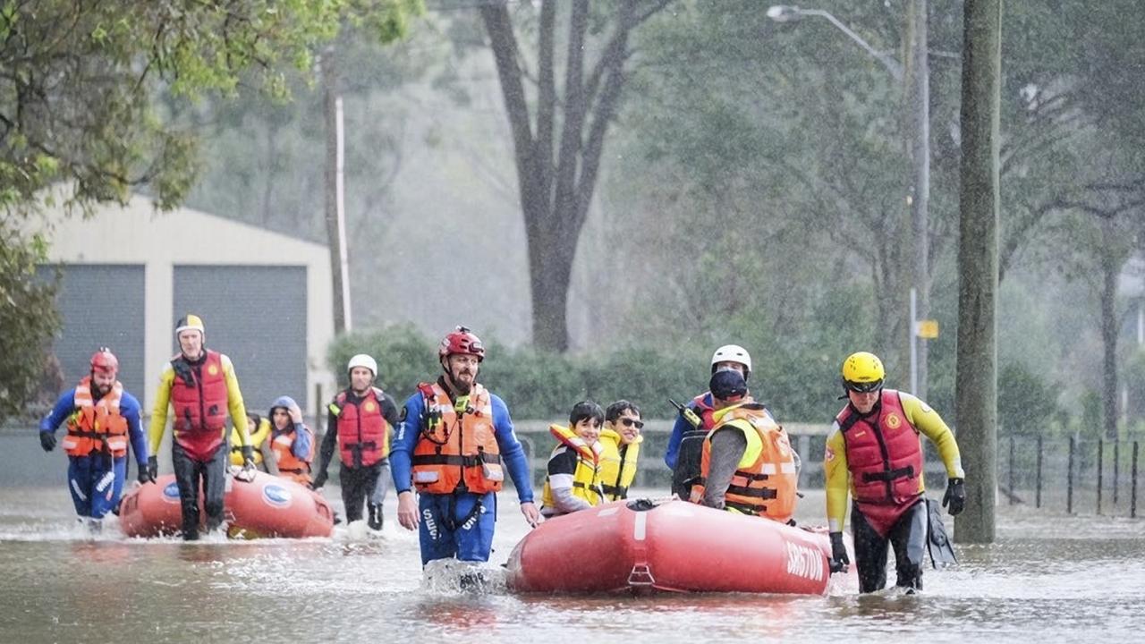
The State Emergency Service (SES) has received more than 1500 requests for help and performed nearly 120 rescues. The Australian Defence Force has made available 100 troops to help in rescue efforts and provided two helicopters to help in the search for stranded people.
One person died when their kayak overturned in the Parramatta River while a pregnant women was among those rescued.
Talking to Channel 9’s Todayprogram on Monday, Weatherzone meteorologist Ben Domensino said Sydney was getting the equivalent rainfall of all the water in Sydney Harbour each day during the current weather event.
“It is hard to fathom that we are seeing a rain event of this magnitude hitting this part of Australia once again.
“We have had several of them already this year but this one in particular has been exceptional heavy for areas near and south of Sydney.”
Over just three days, parts of the Illawarra region have seen more rain than Melbourne or Hobart seen in an entire year.
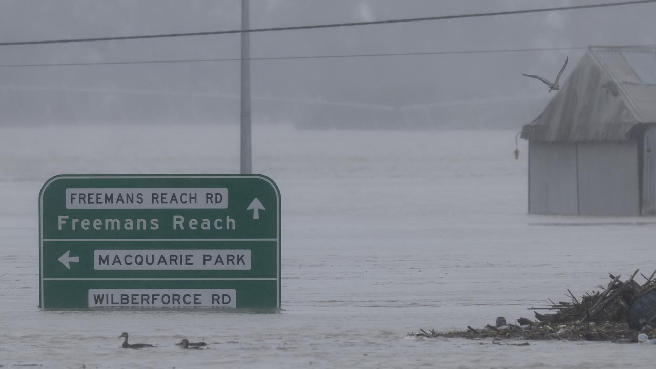
The Hawkesbury suburbs of Richmond, Windsor, Sackville and Wisemans Ferry have been impacted hardest and will likely see extensive flooding in the coming 24 hours. Water levels have also been rising near Liverpool in the city’s south west.
Overnight, residents in parts of Chipping Norton, Londonderry, Wilberforce, Woronora, Cattai, Richards, Georges Hall, Moorebank, Mulgrave, McGraths Hill, Vineyard, Lansvale, Pitt Town and Wisemans Ferry were told to leave their homes by the SES.
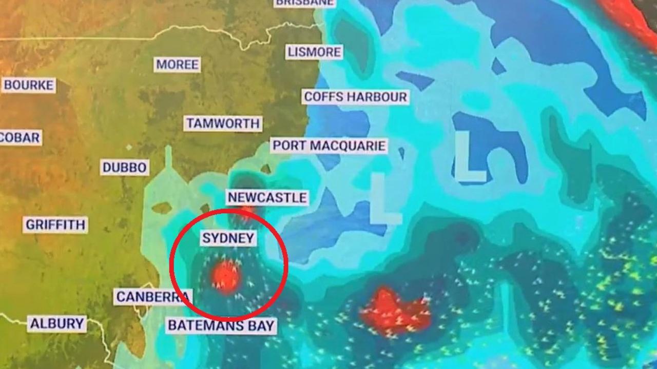
Fresh low coming for Sydney
Holsworthy Barracks, in Sydney’s south, recorded 128mm of rain from 9am Monday, bringing its three day total to 466mm. Lucas Heights, in the Sutherland Shire, is now sitting at more than half a metre of rain in 72 hours.
“Before this rain arrived, we had catchments that were still fairly wet and close to capacity. So it hasn’t taken a lot of rain for the rivers to respond and go back into a major flood, “said Sky News Weather senior meteorologist Tom Saunders.
Showers will remain for Sydney over the coming days, but the totals will be far lower compared to the weekend. The city could see 15-20mm on Tuesday, less than 5mm on Wednesday and up to 15mm on Thursday.
With the system moving north, it’s these areas that could see heavier falls. Newcastle, for instance, could record 35-50mm on Tuesday before rainfall levels weaken. Although there will be showers all week. Port Macquarie could see up to 25mm on Tuesday and then 25-45mm on Wednesday.
But weather trouble is brewing once again.
“It looks like we’ll get another couple of Tasman low pressure systems forming up through the weekend,” said Mr Saunders.
“One could form closer to the coast and perhaps even bring a burst of heavy rain again, most likely for the southern and central NSW coast.”
But Sky’s Mr Saunders cautioned that the potential lows were still a long way off and their energy and location could change and so the forecast could change.
The current Bureau of Meteorology outlook suggest showers on Saturday increasing for Sunday.
Current flood evacuation orders
The SES has now issued more than 70 evacuation warnings and orders across the Sydney basin, as of 6am Tuesday.
People have been ordered to evacuate the following areas. Note that the time of evacuation can vary so check with the SES.
– Mulgrave
– McGrath Hill
– Parts of Chipping Norton
– Warwick Farm Racecourse
– Parts of Richards
– Low lying parts of Bonnet Bay
– Parts of Wilberforce
– Parts of Cattai
– Parts of Sackville North
– Parts of Wisemans Ferry
– Parts of Richards
– Parts of Londonderry
– Parts of Riverstone
– Parts of Pitt Town (southern end) and Pitt Town Bottoms
– Parts of Agnes Banks
– South Maroota (west)
– Parts of Penrith – Peach Tree Creek South
– Central Part of Yarramundi
– Parts of Emu Heights (north)
– Parts of Emu Plains (north east)
– Sackville (north and north east, Tizanna Rd, Madeline Pl)
– Parts of Sackville North (Mud Hill Rd, Pages Wharf Rd)
– Lower Portland (west, east and north, eastern side of Hawkesbury River)
– Parts of Leets Vale
– Cumberland Reach
– Parts of Oakville (Saunders Rd)
– Windsor (close to river)
– Parts of Ebenezer (Tizanna Rd, Hendrens Rd, Ebenezers Wharf Rd, Coromandel Road, Port Erringhi Road)
– Low-lying part of Freemans Reach
– North Richmond (parts of Terrace Road)
– Cornwallis and eastern part of Richmond Lowlands
– Western part of Richmond Lowlands
– North of Bligh Park
– Gronos Point
– Parts of Pleasure Point
– Bents Basin area
– Parts of Wallacia
– Parts of Camden (Ellisa la, Christopher Ave, Edward St, Sheathers Lane, Chellaston and Cawdor, Cut Hill and Cobbity)
– Low lying parts of Woronora
– Parts of Georges Hall
– Parts of Lansvale
– Parts of Moorebank.
Flood evacuation centres
The SES has established several evacuation centres across flood affected parts of Sydney.
These are at:
– Canley Vale – Cabra-Vale Diggers Club, 1 Bartley Street
– Narellan – Family & Community Centre, Queen Street
– Gymea – Gymea Tradies Club, Kingsway
– Richmond – Richmond Club, Market Street
– North Richmond – North Richmond Community Centre, William Street
– Castle Hill – RSL, 77 Castle Street
– Castle Hill – Castle Hill Showground, Showground Road
– Gosford – RSL Club, 26 Central Coast Highway
– Liverpool – Whitlam Aquatic Centre, 90 Memorial Ave.
A full and updated list of evacuation warnings, evacuation orders and evacuation centres can be found at the SES NSW website.
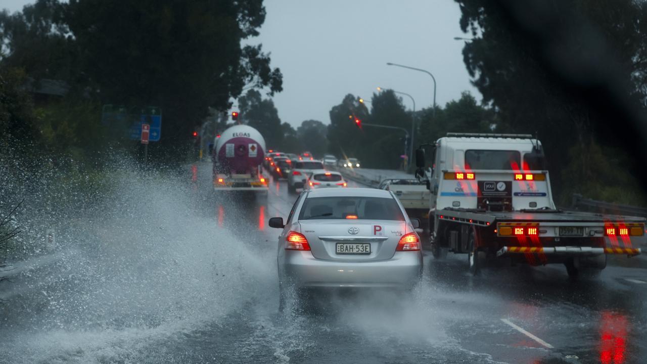
Roads, trains and other transport affected by the weather
Road closures around Sydney, Wollongong and Newcastle (as of 6am Tuesday)
– Milperra to Lansdowne – Henry Lawson Drive is closed between Milperra Road and the Hume Highway
– Milperra to Moorebank – Milperra Road/Newbridge Road is closed between Marigold Street and Governor Macquarie Drive
– Holsworthy to Voyager Point – Heathcote Road is closed between Macarthur Drive and The Ave
– Heathcote to Lucas Heights – Heathcote Road is closed between the Princes Highway and New Illawarra Road
– Liverpool/Warwick Farm – there are intermittent closures at the Hume Highway and Cumberland Highway/Orange Grove Road, due to flooding at the intersection.
– Cartwright – Hoxton Park Road is closed between Banks Road and Ash Road
– Cartwright – Joadja Road is closed between Hoxton Park Road and Jedda Road
– Bossley Park to Wetherill Park – Cowpasture Road is closed between Restwell Road and The Horsley Drive
– Erskine Park: Lenore Drive is closed between Erskine Park Road and Old Wallgrove Road
– Oxford Falls – Oxford Falls Road is closed between the Wakehurst Parkway and Aroona Road
– Windsor – Windsor Bridge is closed between Wilberforce Road and George Street. Sections of Wilberforce and Pitt Town roads are also closed
– North Richmond – Richmond Bridge is closed in both directions
Yarramundi – Yarramundi Bridge is closed in both directions
– Wallacia to Glenmore Park – Mulgoa Road is closed in both directions between Park Road/Silverdale Road and Glenmore Parkway
– Barrengarry – Moss Vale Road is closed in both directions between Bunkers Hill Road and Myra Vale Road due to landslips.
– Albion Park – the Illawarra Highway is closed between – Tongarra Road and the M1 Princes Motorway
– In the Royal National Park, Audley Weir is closed in both directions
– Whittingham – Golden Highway closed in both directions between New England Highway and Putty Road.
Train, ferry and bus changes around Sydney, Wollongong and Newcastle (as of 6am Tuesday)
– T1 Western Line – buses are replacing trains between Schofields and Richmond due to flooding on the tracks
– Blue Mountains Line – buses may replace some trains between Penrith and Springwood
– Southern Highlands Line – buses may replace some trains between Campbelltown and Moss Vale
– South Coast Line – limited buses are replacing trains between Waterfall and Thirroul
– Hunter Line – trains are not running between Newcastle Interchange, Scone and Dungog in both directions due to flooding on the tracks at Sandgate
– Many bus services are affected by flooding across Sydney and may divert at short notice or terminate early. Currently several buses near St Marys have also been diverted and are missing stops due to flooding.
Check the Transport for NSW website for latest information
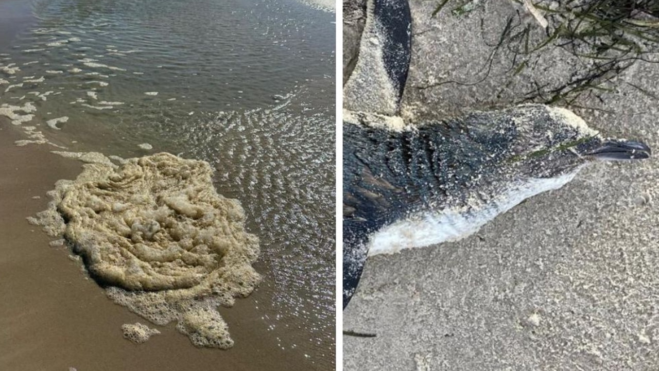
Horror discoveries at popular beaches
Experts have warned residents to stay away from the water at popular beaches after scores of dead marine life washed up on the shore.
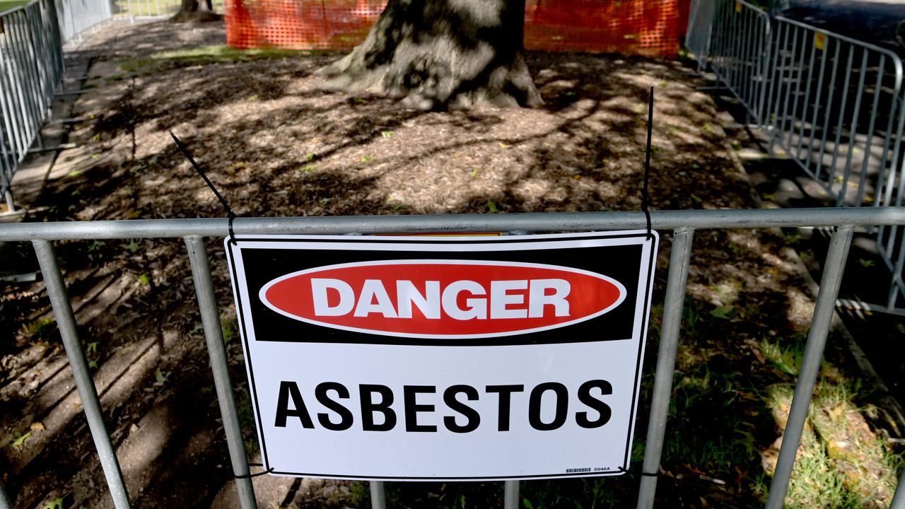
Concerns after asbestos found in park
Warning signs and metal fences have been put up around a park in one major city’s most recent asbestos-related incident.
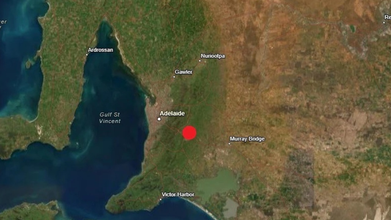
Twin quakes rock two Aussie cities
Hundreds of residents reported feeling the ground move as two separate earthquakes struck Victoria and South Australia just hours apart overnight.