
Sydney weather: 30k told to leave homes as suburbs under evacuation orders, weather latest, road and transport updates
More than 30,000 people have been told to evacuate their homes as Sydney’s flood emergency continues to endanger Sydney suburbs.
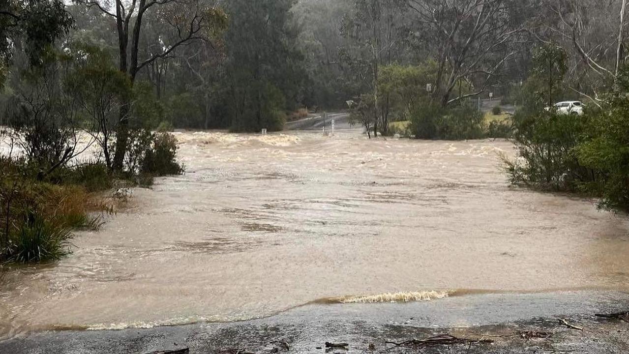
Tens of thousands of people across Sydney face a night from hell as evacuations force them to flee their homes.
More than 30,000 people have been told to evacuate their homes as Sydney’s flood emergency continues.
Emergency Management Minister Murray Watt declared a state of natural disaster for 23 NSW local government areas about 11pm overnight — meaning impacted residents may be eligible for payments.
“We have seen some of these impacted communities being hit by floods for a third and fourth time in 18 months, which is extremely distressing to the residents of these communities,” Senator Watt said.
The Hawkesbury suburbs of Richmond, Windsor, Sackville and Wisemans Ferry have been impacted hardest and will likely see extensive flooding in the coming 24 hours.
Late on Monday night, parts of Chipping Norton and Lower Portland were ordered to leave their homes by 11.45pm and 2am respectively.
Rapid river level rises were detected upstream of Liverpool, prompting the Bureau of Meteorology to issue a flood warning for Liverpool and Milperra.
The NSW SES immediately ordered residents in low-lying parts of Woronora and Bonnet Bay to evacuate.
Those in the following parts of Woronora are being ordered to evacuate as soon as they can are Harrison Ave, McKinley Ave, Washington Drive, Wilson Place.

Those in the following parts of Bonnet Bay are being ordered to evacuate by 8pm: Johnson Close, Arthur Place and properties on Lower Washington Drive backing on to Johnson Close.
The Bureau says major flooding is possible at Liverpool and Milperra during Monday evening.
People living near Warwick Farm Racecourse, as well as parts of Chipping Norton, Georges Hall, Moorebank and Lansvale were all told to leave by 9pm.
All those living on Governor Macquarie Drive between Barry Road & Newbridge Road, bordering west of Riverside Road in Chipping Norton, were told to leave by 11.45pm.
The same message was sent to people living on Governor Macquarie Drive bounded by Georges River on the west and north and by Ernest Street on the east including South Park and Chipping Norton Public School.
Some people on West Portland Road in Lower Portland were also told to evacuate.
Earlier on Monday, evacuation orders were issued for parts of Cattai, Sackville North, Londonderry and Richards.
NSW SES updated their flood evacuation notice to include Wisemans Ferry at 4pm on Monday afternoon. A full list of the affected suburbs can be accessed below.
Authorities have pleaded with residents to cancel holidays and avoid floodwaters, as parts of NSW and the Illawarra continue to be inundated with rescue requests.
In a press conference on Monday morning, NSW Premier Dominic Perrottet said that a massive 71 evacuation orders and 64 evacuation warnings were in place, with 83 flood rescues and 1593 requests for assistance lodged since 9pm Sunday.
While flood waters have peaked, or are close to peaking in Menangle, and North Richmond, the situation is expected to worsen for the Windsor and the Lower Portland areas. Major flooding has been predicted to hit on Monday afternoon, before it moves downstream to Sackville and Wisemans Ferry.
Mr Perrottet also issued a stern warning for affected residents to abide by instructions and in particular, to strictly avoid driving into flood waters.
“If there is an evacuation warning in place, please get ready to evacuate. If there is an evacuation order in place, please leave immediately,” he said.
“These instructions, warnings, orders, they are not in place for the sake of it.”
Despite three days of devastating rain, Minister for Emergency Services and Resilience and Minister for Flood Recovery Steph Cook warned the state was “not quite out of the woods yet”.
She said a Commonwealth announcement for wider recovery measures would be announced on Tuesday, however the process would be kickstarted where it was possible to do so.
The Australian Defence Force has received requests for additional support under the Commonwealth disaster recovery plan.
“We have SES communities at the Georges River area, looking at the impact of this latest flooding on people’s homes, their businesses and the local infrastructure, working closely with councils, of course, to make sure that is all captured,” said Ms Cook.
“That will form the basis of our discussions with the Federal Government in relation to rolling up support for communities as we look to get people back on their feet.”
Army called in to evacuate stranded families
Heavy military vehicles and personnel were rolled out onto Sydney streets on Monday to assist with damaging flooding.
Over 100 Australian Defence Force (ADF) personnel have been tasked with assisting evacuations and conducting welfare door knocks.
Two ADF helicopters were also deployed for the purpose of night searches as water levels continued to threaten communities.

Prime Minister Anthony Albanese urged those affected to stay safe after returning from war-torn Ukraine on Monday afternoon (AEST).
Mr Albanese visited Ukraine over the weekend where he met President Volodymyr Zelensky.
The Prime Minister confirmed he had been briefed on the situation by NSW Premier Dominic Perrottet and Emergency Management Minister Murray Watt.
“Have crossed into Poland from Ukraine and left radio silence,” Mr Albanese tweeted.
“It’s a constantly changing situation. Check @NSWSES and @BOM_NSW for the latest advice and stay safe.”
Pregnant mum plucked from danger
A family of five were plucked from danger on Monday evening after their car was nearly submerged in floodwaters.
A pregnant mum was among those saved by specialist Fire and Rescue NSW officers at the corner of The River Road and Prince Street in Revesby Heights just before 5.30pm.
The crew guided one woman from a car to safety and then discovered the family in another vehicle, stranded in the middle of the road.

A father, his pregnant wife, and three children, all believed aged under six, were unable to escape the vehicle, due to floodwaters lapping at the doors.
The fire crew, trained in swift-water rescues, waded out to the vehicle and fitted life jackets to the family.
The firefighters safely carried the children in their arms as they guided the parents through the floodwaters to waiting relatives nearby.
No-one was hurt in the incident.
Conditions ‘too rough’ to winch stranded crew
Concerns have also been made for a bulk carrier vessel in Portland Bay which departed Wollongong on Monday morning.
Carrying 21 crew members, the ship had lost power near the Royal National Park, with fears it risked crashing into a cliff face a mere 1km away.
#WATCH // @Lifesaverhelo is responding to a stranded container ship off the Royal National Park. Conditions are currently too rough to attempt to winch the crew from the ship.
— Surf Life Saving NSW (@slsnsw) July 4, 2022
The ship has no power and is currently 1nm offshore. IRBS from #thirroulslsc and a jetski are on standby pic.twitter.com/O5s5TViek5
Bulk carrier Portland Bay looks out of control very close to running aground near Sydney’s Royal National Park. pic.twitter.com/LKB9Zaho78
— Ronaldo (@RoryRonaldo) July 3, 2022
Mr Perrottet said the vessel was in a “very precarious position,” however the ship was currently double anchored, with a rescue plan in place. Two tug boats have been sent to direct the ship away from the cliff face.
In an update from Surf Life Saving NSW, it said the conditions were too rough for Westpac Rescue Helicopters, who were unable to winch the crew from the stranded ship.
Weather for Monday in affected areas of NSW
The Bureau of Meteorology has issued a number of severe weather warnings in the wake of the East Coast Low.
The weather system touched land late on Sunday and is forecast to linger for another day, before steadily moving north.
The low has weakened, but the trough is still directing humid air onshore, causing moderate to at times heavy rainfall. Drier air will push gradually northwards up the NSW coast through the afternoon, clearing most of the rain out of the Illawarra, Blue Mountains and Sydney regions by late this evening.
The BOM said although rain rates have generally eased, heavy falls are still possible today in the Illawarra region, the Blue Mountains, Sydney, central coast and parts of the Hunter. Six-hourly rainfall totals between 60 to 100mm are possible and that could lead to flooding.
The low is causing very heavy surf which may lead to localised damage and coastal erosion.
Significant wave heights of over five meters are likely, with peak periods around 11 seconds.

Flood evacuation orders
The State Emergency Service (SES) has now issued more than 50 evacuation warnings and orders across the Sydney basin, as of 11.30pm Monday.
People have been ordered to evacuate the following areas. Note that the time of evacuation can vary so check with the SES.
– Mulgrave
– McGrath Hill
– Parts of Chipping Norton
– Warwick Farm Racecourse
– Parts of Richards
– Low lying pats of Bonnet Bay
– Parts of Wilberforce
– Parts of Cattai
– Parts of Sackville North
– Parts of Wisemans Ferry
– Parts of Richards
– Parts of Londonderry
– Parts of Riverstone
– Parts of Pitt Town (southern end) and Pitt Town Bottoms
– Parts of Agnes Banks
– South Maroota (west)
– Parts of Cattai (Riverside Caravan Park)
– Parts of Lower Portland (north east)
– Parts of Penrith – Peach Tree Creek South
– Central Part of Yarramundi
– Parts of Emu Heights (north)
– Parts of Emu Plains (north east)
– Sackville (north and north east, Tizanna Rd, Madeline Pl)
– Parts of Sackville North (Mud Hill Rd, Pages Wharf Rd)
– Lower Portland (west, east and north, eastern side of Hawkesbury River)
– Parts of Leets Vale
– Cumberland Reach
– Parts of Oakville (Saunders Rd)
– Windsor (close to river)
– Parts of Ebenezer (Tizanna Rd, Hendrens Rd, Ebenezers Wharf Rd, Coromandel Road, Port Erringhi Road)
– Low-lying part of Freemans Reach
– North Richmond (parts of Terrace Road)
– Cornwallis and eastern part of Richmond Lowlands
– Western part of Richmond Lowlands
– North of Bligh Park
– Gronos Point
– Parts of Pleasure Point
– Bents Basin area
– Parts of Wallacia
– Parts of Camden (Ellisa la, Christopher Ave, Edward St, Sheathers Lane, Chellaston and Cawdor, Cut Hill and Cobbity)
– Low lying parts of Woronora
– Parts of Georges Hall
– Parts of Lansvale
– Parts of Moorebank
– Parts of Warwick Farm
– Parts of Lower Portland

Flood evacuation centres
The SES has established several evacuation centres across flood affected parts of Sydney.
These are:
– Canley Vale – Cabra-Vale Diggers Club, 1 Bartley Street
– Narellan – Family & Community Centre, Queen Street
– Gymea – Gymea Tradies Club, Kingsway
– Richmond – Richmond Club, Market Street
– North Richmond – North Richmond Community Centre, William Street
– Castle Hill – RSL, 77 Castle Street
– Castle Hill – Castle Hill Showground, Showground Road
– Gosford – RSL Club, 26 Central Coast Highway
– Liverpool – Whitlam Aquatic Centre, 90 Memorial Ave
A full and updated list of evacuation warnings, evacuation orders and evacuation centres can be found at the SES NSW website.

Roads, trains and other transport affected by the weather
Road closures around Sydney, Wollongong and Newcastle (as of 7am Monday)
– Milperra to Lansdowne – Henry Lawson Drive is closed between Milperra Road and the Hume Highway.
– Milperra to Moorebank – Milperra Road/Newbridge Road is closed between Marigold Street and Governor Macquarie Drive.
– Holsworthy to Voyager Point – Heathcote Road is closed between Macarthur Drive and The Ave
– Heathcote to Lucas Heights – Heathcote Road is closed between the Princes Highway and New Illawarra Road.
– Liverpool/Warwick Farm – there are intermittent closures at the Hume Highway and Cumberland Highway/Orange Grove Road, due to flooding at the intersection.
– Cartwright – Hoxton Park Road is closed between Banks Road and Ash Road.
– Cartwright – Joadja Road is closed between Hoxton Park Road and Jedda Road.
– Bossley Park to Wetherill Park – Cowpasture Road is closed between Restwell Road and The Horsley Drive.
– Erskine Park: Lenore Drive is closed between Erskine Park Road and Old Wallgrove Road
– Oxford Falls – Oxford Falls Road is closed between the Wakehurst Parkway and Aroona Road
– Windsor – Windsor Bridge is closed between Wilberforce Road and George Street. Sections of Wilberforce and Pitt Town roads are also closed.
– North Richmond – Richmond Bridge is closed in both directions.
Yarramundi – Yarramundi Bridge is closed in both directions.
– Wallacia to Glenmore Park – Mulgoa Road is closed in both directions between Park Road/Silverdale Road and Glenmore Parkway.
– Barrengarry – Moss Vale Road is closed in both directions between Bunkers Hill Road and Myra Vale Road due to landslips. Albion Park – the Illawarra Highway is closed between – Tongarra Road and the M1 Princes Motorway.
– In the Royal National Park, Audley Weir is closed in both directions.
– Whittingham – Golden Highway closed in both directions between New England Highway and Putty Road.
UPDATE: Golden Hwy (Mitchell Line of Rd) remains closed between the New England Hwy and Putty Rd due to flooding. Travel via Singleton instead. pic.twitter.com/hltgYaS6f9
— Live Traffic NSW (@LiveTrafficNSW) July 4, 2022
Train, ferry and bus changes around Sydney, Wollongong and Newcastle (as of 11.30pm Monday)
– T1 Western Line – buses are replacing trains between Schofields and Richmond due to flooding on the tracks.
– Blue Mountains Line – buses may replace some trains between Penrith and Springwood
– Southern Highlands Line – Buses may replace some trains between Campbelltown and Moss Vale
South Coast Line – limited buses are replacing trains between Waterfall and Thirroul
– Hunter Line – trains are not running between Newcastle Interchange, Scone and Dungog in both directions due to flooding on the tracks at Sandgate.
– Many bus services are affected by flooding across Sydney and may divert at short notice or terminate early. Currently several buses near St Marys have also been diverted and are missing stops due to flooding.
Check the Transport for NSW website for latest information
Man dies in NSW floods
A fierce East Coast Low weather system is battering a huge stretch of the New South Wales coast.
But it’s saved the majority of its weather wrath for Sydney and the Illawarra.
Forecasters have said the horrendous conditions will continue on Monday, with up to 100mm of rain due to fall in Sydney, 150mm possible in Wollongong and up to 200mm in isolated pockets elsewhere.
Those totals can be added to the huge amount of rain that’s fallen over the last few days.
One man has died and flash and riverine flooding has occurred in and beyond Sydney.
“The next 24 hours will decide how high the floods peak along the Hawkesbury River such as around Richmond, where the water levels have already risen substantially,” said Sky News Weather meteorologist Rob Sharp.
“And they could go a lot further than that, depending on how much falls with this system.”
Here we’ve complied a list of all the suburbs affected by evacuation orders, the location of evacuation centres and the roads and public transport affected by the weather.
Full list of suburbs with evacuation notices:
Full list of suburbs with evacuation notices
Wiseman’s Ferry, Wiseman’s Ferry West, Parts of Richards, Parts of Wilberforce, Parts of Cattai, Parts of Sackville, Parts of Londonderry, Parts of Ebenezer, Parts of Riverstone, Parts of Pitt Town, Agnes Banks Lowlands North, South Maroota West, Parts of Lower Portland, Northern part of Yarramundi, Parts of Penrith, Central Part of Yarramundi, Wallacia Caravan Park, Parts of Emu Heights North, Parts of Emu Plains North East, Parts of Lower Portland North, Parts of Leets, Cumberland, Lower Portland on eastern side of Hawkesbury River, Windsor, Clarendon, Leonay, McGraths Hil, Emu Plains, Penrith, Mulgrave, Lake Illawarra, Regentville and Moorebank.

‘Total madness’: Net-zero review slammed
The Nationals' push to abandon net-zero targets has been slammed as Australia grapples with its role as a major fossil fuel exporter.
Read more

Snow predicted in surprising state
Residents of a state renowned for its beautiful beaches and tropical climate have been warned to prepare for potential snow this weekend.
Read more

200 species dead in ‘unprecedented’ disaster
Scientists have offered a grim outlook for Aussies hoping for an immediate solution to an ‘unprecedented’ disaster leaving the water at Aussie beaches toxic.
Read more