
Records broken as wild weather hits and East Coast Low brews
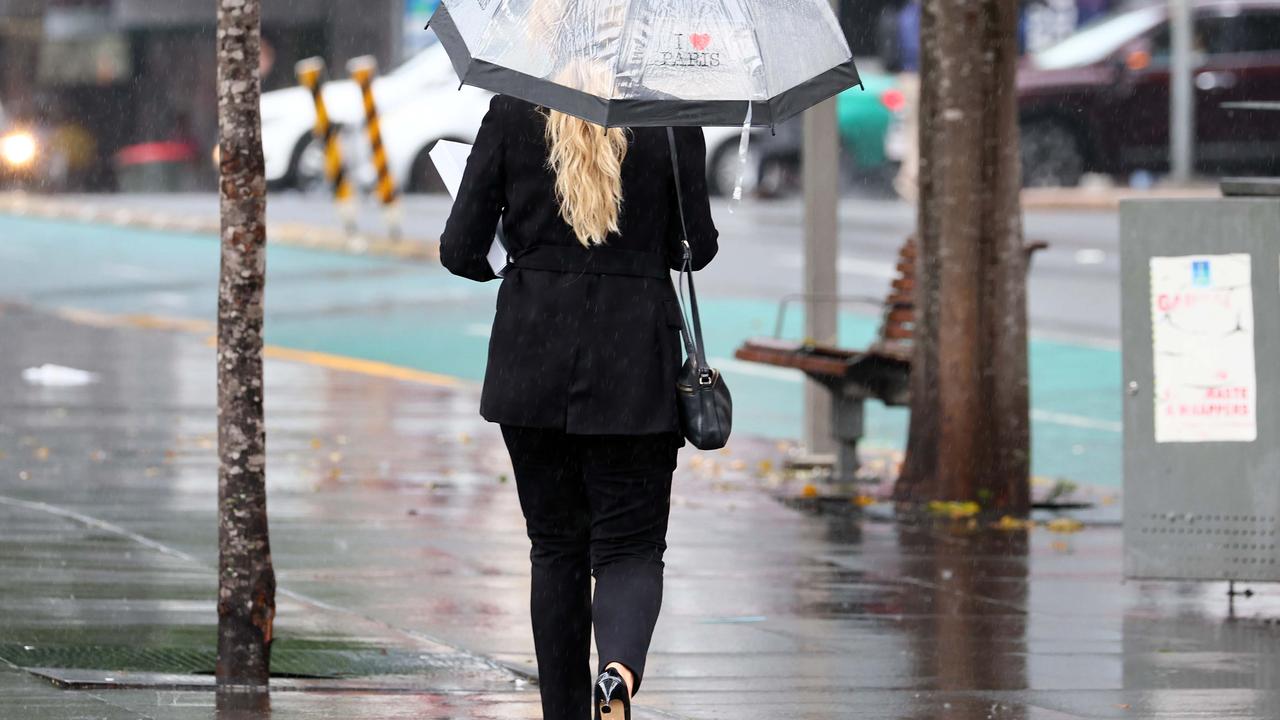
Some places have seen more than 200mm of rain but forecasters have warned things will only get more intense as an East Coast Low nears.


Residents in a number of suburbs in and around Sydney have been told to leave their homes as monster rain leads to rising floodwaters.
In Camden, in Sydney’s worth west, 105mm of rain has fallen since 9am on Saturday; in Lucas Heights, in the city’s south, 175mm has come down.
Overnight, the State Emergency Service has issued evacuation orders and warnings for parts of the local government areas of Liverpool and Camden with evacuation centres set up in Narellan and Canley Vale.
Around midnight and evacuation order was pout in place for low lying areas of Woronora in the Sutherland Shire with a warning that once floodwaters reach 1.7 metres at the Woronora Bridge, the suburb will be cut off.
‼ EVACUATION ORDER Low lying parts of Woronora ‼
— NSW SES (@NSWSES) July 2, 2022
NSW SES is directing residents and businesses within low lying parts of Woronora to evacuate now.
Go to https://t.co/BCnxAe6tsR for the complete evacuation order with exact locations affected and nearest evacuation centre. pic.twitter.com/GhJSyA1e79
Evacuation orders and warnings have been issued tonight for parts of Liverpool and Camden. Please check https://t.co/FZooFaAris for the latest.
— NSW SES (@NSWSES) July 2, 2022
Evacuation centres will be updated on our website: https://t.co/ccl8K6IQh7
Forecasters had warned that the immense amount of rain bucketing down on Sydney and the Illawarra, due to a forming East Coast Low, was “essentially guaranteed” to lead to flooding particularly in the Hawkesbury-Nepean catchment in the city’s west.
As at 12.30am on Sunday morning, the Bureau of Meteorology had issued a moderate to major flood warning for the Nepean, Hawkesbury and Colo rivers. Major flooding was possible at North Richmond on Sunday evening.
Stream more weather news live & on demand with Flash. 25+ news channels in 1 place. New to Flash? Try 1 month free. Offer ends 31 October, 2022 >

Senator Murray Watt, the federal Minister Emergency Management, said his government had approved a NSW government request for two Defence Force helicopters and a hundred troops to assist with operations, should they be needed.
“Thanks to the NSW government for their early request – co-operation and proactive action ensures we are prepared,” said Mr Watt.
He added that “major flooding” was possible on Sunday.
In a warning issued at about 6pm on Saturday evening, the Bureau of Meteorology echoed that sentiment, highlighting the risk of flooding at Menangle and North Richmond.
Meanwhile the SES said it would be issuing emergency alert SMS messages to communities along the Hawkesbury-Nepean catchments “in preparation for potential evacuations overnight and over the coming days as rain intensifies across Sydney and the Illawarra”.
Century-long record tumbles
Some NSW regions have already seen a month’s worth of rainfall in less than one day.
The Illawarra copped torrential rain on Friday and Saturday morning.
In the 24 hours to 9am Saturday, Foxground recorded 215mm, Albion Park 171mm and Kiama 163mm.
According to Sky News Weather, for Albion Park it is the heaviest July rain since 1904.
“Kiama has already seen over 160mm of rain and the local creeks and rivers started to rise along with that threat of flash flooding,” Sky News Weather channel senior meteorologist Tom Saunders said.
On Sunday and Monday, the heaviest rain is likely to fall in the Illawarra, Sydney and up into the Hunter Region.
Mr Saunders said there were “lots of centres” to the low and one of them could end up sitting right near the NSW Central Coast during Sunday night and Monday morning.
“If that were to occur, we’re not only looking at the heavy rain but damaging winds … we could see gusts up to 100km an hour and with the very wet ground that could mean trees uprooted, so we’re looking at a bit of damage from the system,” he explained.
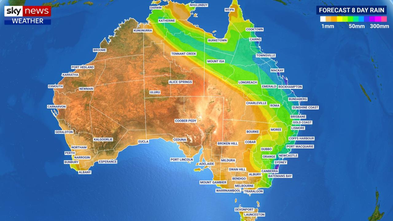
It’s not just New South Wales in danger – Queensland, too, is looking distinctly soggy over the coming days.
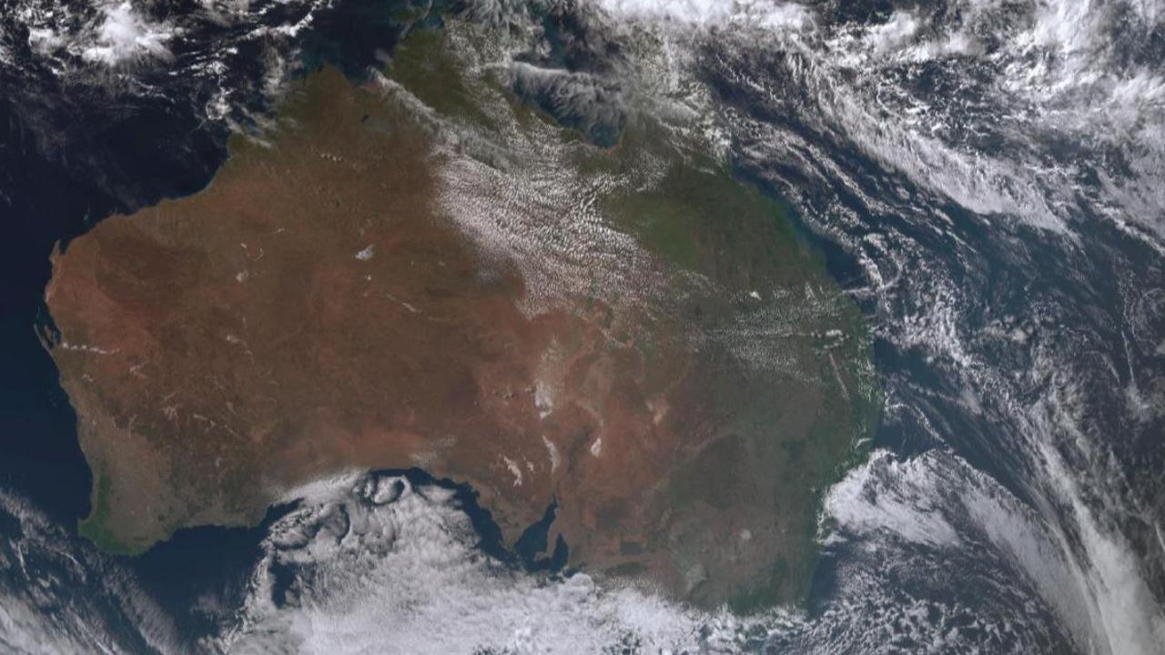
East Coast Low
An upper level trough is the cause of the weather drama, pushing cool air up from southern Australia.
That trough will interact with tropical moisture further north to produce these windy and wet intense weather systems.
“A trough is developing just off the NSW coast,” Mr Saunders said on Friday.
“We expect that trough will deepen over the weekend to a fully-fledged East Coast Low.
“These systems are notoriously difficult to forecast exactly when and where they’ll strike but at this stage, it looks like it’s that central part of the NSW coast with rain also impacting northern parts of the country,” he said.
Flash flooding ‘essentially guaranteed’
East Coast Lows have many of the characteristics of cyclones but aren’t classified as such, as they are in subtropical waters. But they can still bring immense amounts of rain, gales and coastal erosion.
“Flash flooding and river flooding is essentially guaranteed.,” Mr Saunders said of the impacts of this weekend’s weather.
“Damaging winds and power outages are possible particularly towards the back end of the weekend into early next week.”
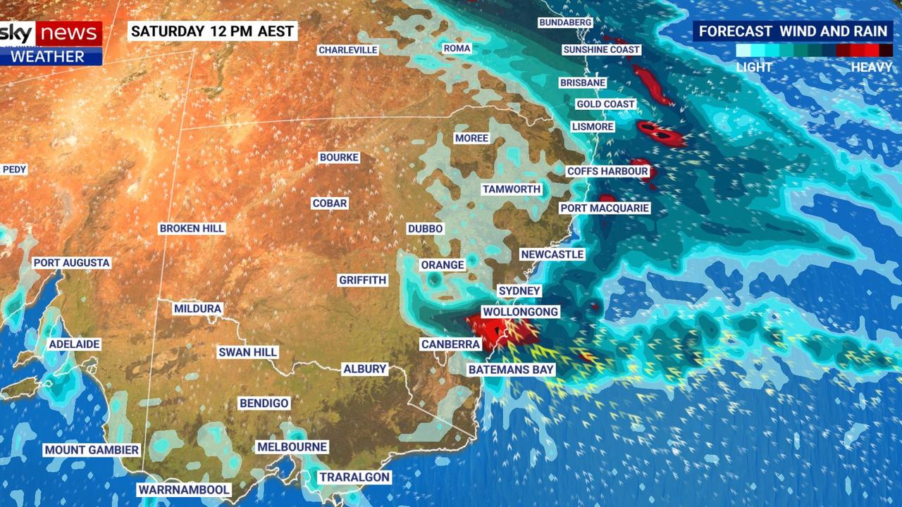
So how much rain could come down? Well it depends on the meteorological model but 200-300mm is a possibility with a chance of up to 400mm in isolated areas and around Sydney, Wollongong and across the Blue Mountains. And that’s really not great.
“That’s covering the Hawkesbury Nepean catchment and that catchment is still quite wet and that would certainly be enough rain for major flooding,” he said.
If that happens, parts of Sydney’s western and northern fringes could be inundated.
The Bureau of Meteorology has issued a severe weather warning for heavy rainfall starting on Saturday, from around Ulladulla to Sydney.
NSW SES Commissioner Carlene York said because dams and rivers were already full, there was “significant” concern about what is to come for communities across the state.
“This significant rain event could have some major effects across communities from Port Stephens down to Batemans Bay so we’re preparing and getting community messaging out to let them know they’re in some of these areas of risk and to be ready.”
The Bureau is forecasting 60-90mm falling on Saturday in Sydney, 100-150mm on Sunday and up to another 80mm on Monday. Maximus should be around 17C.
It could be even heavier in Wollongong and the Blue Mountains with 150-200mm possible on Sunday alone.
Newcastle is looking at 35-50mm on Sunday and 50-80mm on Monday. Further north, there could be some showers over the weekend for places like Port Macquarie and Grafton but the totals will be far lower. Inland areas and southern NSW could also see rain but again it will be far less heavy than the Sydney basin.
Canberra is forecast to see between 10-25mm of rain between Saturday and Monday.
Queensland to be drenched
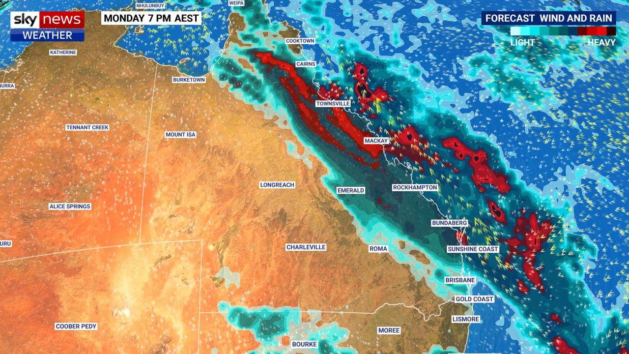
Widespread rain continues across Queensland. It will ease off on Saturday but should start bubbling up again on Sunday with the heaviest falls seen early in the week.
Across northern parts of the coast, rain totals of 100mm are on the cards.
Townsville will see some showers as the weekend progresses, but Monday is when it will chuck it down, with 40-60mm forecast, and more for Tuesday.
More Coverage

In Brisbane, Saturday is looking like the soggiest day, with up to 25mm of rain then lessening on Sunday. But Tuesday could again see downpours. The other capitals will have a very different weekend with Melbourne, Adelaide and Hobart all remaining dry and partly cloudy with almost uniform mid teen highs.
Darwin will see some blue skies with maximums of 29C. But it’s Perth that will be gloriously sunny. But it will be relatively mild with temperatures only just nudging 20C.
– with Ben Graham and Chantelle Francis

World stunned by development in Antarctica
It’s been shrinking for decades but latest scientific findings show a shock development in Antarctica - and it’s sparked fierce debate online.
Read more
East coast to cop more showers
With winter just weeks away Aussies are still basking in warm and sunny conditions, unless you are on the east coast.
Read more
Wild weather to smash the east coast
BOM has issued warnings for heavy winds, despite mostly “settled” weather across most of the nation.
Read more