Dangerous double rain systems zero in on Queensland’s north and east
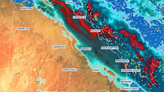
Queensland is bracing for days of “unseasonably” wet weather as a double whammy of treacherous rain systems are set to smash much of the state, bringing dangerous downpours and a possible East Coast Low.

QLD weather news
Don't miss out on the headlines from QLD weather news. Followed categories will be added to My News.
Queensland is bracing for an “unseasonably” wet weekend as the first of two rain bands shifts it’s way over the southeast with the potential to dump up to 50mm in some areas on Saturday.
High rainfall totals are expected to hit the northern tropical coast today, with central and southern coastal areas set to cop a drenching on Friday and Saturday.
The Bureau of Meteorology’s Brooke Pagel said two rain bands would sweep the state between Friday and Monday, creating heavy localised falls and “significant wind chill,” which could impact livestock.
“We’ll see just one to four millimetres in South East Queensland today, and that’s up to the Wide Bay Burnett area, and then between ten and 15mm tomorrow with some areas possibly getting up to 25mm,” Ms Pagel said.
“It really ramps up on Saturday, that will be out main day where we see areas get between 25 and 50mm, that’s the Sunshine Coast, Brisbane, Gold Coast, Moreton Bay, Wide Bay, while more inland areas like Toowoomba and down to the Darling Downs border will see between 15 and 35mm.”
The first rainband has been generated by an upper trough in Central Australia and is expected to more over Queensland over the next two days and ease off by Sunday, with scattered showers expected throughout the state.
A second rainband is then expected to develop over the south east on Monday however, Ms Pagel says it's too early to tell how impacting it would be, with roughly 10-20mm estimated to fall across the southeast region.
“It’s hard to tell at the moment because it’s potential is hard to call this far out,” she said.
“We’re expecting rain regardless, but the location and how much depends on the low and coastal trough.”

Ms Pagel said the current forecast is unseasonably wetter than usual for “most of Queensland” with higher than average rainfall totals and
“well below” average maximum temperatures expected during the rest of Winter due to the negative Indian Ocean Dipole combined with the neutral La Nina event.
But the Bureau is confident the two rain bands will be “short lived,” in Queensland creating less flood risk than the previous rain events.
“Surprisingly, south east Queensland has dried out a little bit,” Ms Pagel said.
“Because its (rain event) is only 1-2 days, were not expecting too much saturation.”
The Bureau will list any potential hazardous surf warnings on Friday.


